KokomoWX
-
Posts
1,561 -
Joined
-
Last visited
About KokomoWX

- Birthday July 28
Recent Profile Visitors
3,813 profile views


-
The Weather Channel dropped a new two part video on YouTube.
-
All-time March record set in Indy at 88 today.
-

1/24-1/25 Major Winter Storm - S. IL, IN, and OH
KokomoWX replied to A-L-E-K's topic in Lakes/Ohio Valley
Euro still moving north...
-
A memorable event for those of us who have been around a while. Netflix has a moving coming out in March. https://youtu.be/2o0eLtapwr0?si=xDqFJvkSLfVcOGwb
-
No way I get 3" IMBY (OKK). The hour by hour NWS for has 3/4" of rain at 34-36 degrees. What an absolute waste.
-
Kokomo received 3.5 inches. Looks like this will stay for a while with the forecasted deep freeze.
-
I hope your health is better. I was surprised to find Kokomo upgraded from the advisory to a warning. The snow totals remain anemic and dry air is still kicking butt. Maybe we can cash in next time.
-
Fall/Winter '24 Banter and Complaints Go Here
KokomoWX replied to IWXwx's topic in Lakes/Ohio Valley
A complete miss would be more welcome than riding the northern edge all week. Models kept hope alive with 6+/10+ amounts but also showing a near miss south. In the end, I'm in the 1-3"/2-4" area with a 25 mile shift either way having major impacts on the IMBY total. At least I'd not worried about warm air aloft causing disappointment for me. -
One of my favorites.
-
Fall/Winter '24 Banter and Complaints Go Here
KokomoWX replied to IWXwx's topic in Lakes/Ohio Valley
These cold rain systems are really heartbreaking. I'm already seeing at the next solution being a miss south. -
Fall/Winter '24 Banter and Complaints Go Here
KokomoWX replied to IWXwx's topic in Lakes/Ohio Valley
Here is proof that it did snow in December once upon a time. indy_snow_2004_final.pdf -
It also continued over performing in north central Indiana. About 2-3 inches here too. Melting will happen tomorrow reaching mid 50s on Monday.
-
Fall/Winter '24 Banter and Complaints Go Here
KokomoWX replied to IWXwx's topic in Lakes/Ohio Valley
How about "ho ho NO!" -
Fall/Winter '24 Banter and Complaints Go Here
KokomoWX replied to IWXwx's topic in Lakes/Ohio Valley
The 70s were golden years of my youth and great snows. It is too bad we have become snowless tundra these days. -
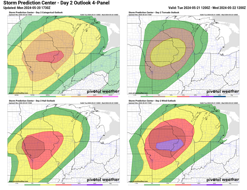
ACUS02 KWNS 201759 SWODY2 SPC AC 201758 Day 2 Convective Outlook NWS Storm Prediction Center Norman OK 1258 PM CDT Mon May 20 2024 Valid 211200Z - 221200Z ...THERE IS A MODERATE RISK OF SEVERE THUNDERSTORMS ACROSS SOUTHERN IOWA...NORTHWEST ILLINOIS AND FAR NORTHEAST MISSOURI... ...SUMMARY... Severe storms are expected Tuesday across the Midwest, especially including portions of Iowa and Missouri into Wisconsin and western/northern Illinois. Tornadoes (a few strong), damaging wind gusts, and large hail are expected. ...Lower/Middle Missouri Valley to the Upper Great Lakes... A notably strong belt of cyclonically curved westerlies (70+ kt 500 mb) will extend from the south-central Great Plains to the Upper Midwest and Upper Great Lakes on Tuesday, with a lead/convectively augmented shortwave trough likely to spread from the central High Plains toward the Lake Superior vicinity late Tuesday night. An elongated surface low over eastern Nebraska Tuesday morning will deepen and lift northeast to northern Wisconsin/Upper Michigan by evening, with a surface warm front lifting northward ahead of the surface low, although its effective position will likely be influenced by the early day precipitation. Meanwhile, a trailing cold front will surge east across Iowa/eastern Kansas/northern Missouri from mid-afternoon into the evening. Remnant clusters of storms will likely be ongoing Tuesday morning across central/eastern Nebraska, with the possibility of additional storms farther east across southern Iowa/northern Missouri in association with a warm-advection regime. Some key uncertainties persist about the influences of this early day convection, but trends will be for quick air mass recovery given a progressive/highly dynamic pattern. Very steep mid-level lapse rates will overspread the increasingly moist warm sector, supporting aggressive diurnal destabilization especially on the southern fringe of lingering convection/cloud cover. Significantly strengthening mid-level winds and a diurnally persistent strong low-level jet will support initial supercells capable of large hail and a few tornadoes, including strong (EF2+) tornado potential. But a mixed/transitional mode is expected overall, as upscale growth occurs given the degree of forcing for ascent, with likely evolution into a well-organized/fast-moving QLCS capable of increasingly widespread/intense damaging winds and a continued QLCS-related tornado risk. This scenario currently appears to be most probable across southern/eastern Iowa into northwest Illinois and nearby far northern Missouri. The severe risk will persist into the Upper Great Lakes region and middle Mississippi Valley overnight. ...Southern Plains... Convective coverage will likely decrease with southward extent as large-scale ascent focuses northward toward the Great Lakes. Nevertheless isolated storms are possible into northeast Oklahoma/northwest Arkansas by late afternoon/evening, and more conditionally with southwest extent near a dryline from central Oklahoma into central Texas. Large hail and severe gusts will be possible with this activity. ...Northeast States... A weak upper shortwave trough will move across southern Quebec and northern New England. This will result in a band of enhanced westerly deep-layer flow from northern New York into Maine. A seasonally moist airmass will be in place with surface dewpoints into the low 60s F, with strong heating and steepening low-level lapse rates. MLCAPE to around 1000 J/kg and effective shear magnitudes around 35 kt will support organized cells. Elongated hodographs and favorable vertical shear suggest marginally severe hail will be possible along with locally damaging wind gusts. ..Guyer.. 05/20/2024