

wxsniss
-
Posts
5,800 -
Joined
-
Last visited
About wxsniss

Recent Profile Visitors
6,871 profile views


.thumb.jpg.aec747d13df1d95d5fed34574f74d4fd.jpg)


-
Fireworks 9pm at Glen Cove / Morgan Memorial park, LI… thoughts? NAMs HRRR are close developing storms into LI sound by 9-10pm
-
Now warned!
-
-
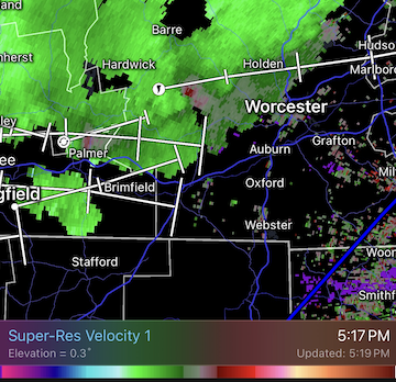
Decent velocity curl west of Worcester 5:15pm...
-
Very loud deep boom, 2:11pm heard in Natick MA Apparently heard across eastern MA and RI
-
Impressive little system, let’s get a critter like this in January MWN earlier this week and now:
-
As usual, model extremes were wrong... not a shutout like AI-GFS had for days, not a 3-day washout like EC / ens had a few days ago... converging towards a 1.5 of 3 days dry: completely dry Saturday (probably copy of today cloudy highs to 60s) worst day Sunday Monday looks dry 2nd half... Only reason I'm scrutinizing is a family event on Charles Saturday evening so thankful it looks dry
-
High stakes weekend... EPS/GEFS and EC are wettest models, but if anything maybe ticking drier AI-GFS/EC and GFS driest... 12z AI-GFS still a shutout until late Monday, but ticking less suppressed
-
Hope so. AI-GFS complete shutout vs. Euro is wet most of Sat night-Monday Box had been riding NBM, 50%+ chance showers all weekend...
-
Surprised by that number. Was about 3 min torrential and occasional pulses of horizontal windswept white curtains of rain, cars slowed down with hazards on, minor transient street flooding… decent but nothing photo-worthy. Didn’t see any tree damage.
-
Let's see if we warn inside 128 Hearing some rumbles near Fenway
-
Have an event on the Charles River near Boston Saturday evening... AI-GFS/ECs for a few days now have led the way keeping the ~1035 high in place east of us and suppressing precipitation southwest of SNE... hope it's correct!
-
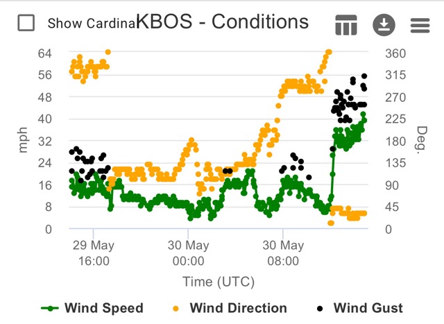
KBOS 170554Z 19029G54KT 62mph
-
At least for inside 128, not feeling a surprise >3" snow: DPs: Still an 850 tongue on 0z NAM 6z: Station: KBOS Latitude: 42.37 Longitude: -71.02 Elevation: 37.29 Press Height Temp Dewpt Dir Spd SFC 1023.6 37 0.5 0.1 51 13 M 1000.0 224 -0.8 -1.1 57 26 S 950.0 633 -1.7 -2.0 86 32 S 900.0 1065 -0.2 -0.5 87 22 M 850.0 1523 0.3 0.0 112 13 S 800.0 2009 -0.1 -0.4 147 9 S 750.0 2526 -0.4 -0.7 201 16 M 700.0 3077 -1.9 -2.3 229 25 9z: Press Height Temp Dewpt Dir Spd M 1000.0 214 -0.7 -9999.0 53 24 S 950.0 624 -0.4 -0.7 91 28 S 900.0 1057 -0.1 -0.4 96 23 M 850.0 1515 0.2 -0.1 123 13 S 800.0 2001 -0.5 -0.7 158 9 S 750.0 2517 -0.7 -1.0 239 16 M 700.0 3067 -2.2 -2.5 261 25
-
6z Friday on NAM: Station: KBOS Latitude: 42.37 Longitude: -71.02 Elevation: 37.36 Press Height Temp Dewpt Dir Spd SFC 1024.1 37 0.1 -0.4 51 13 M 1000.0 227 -1.0 -1.4 57 27 S 950.0 636 -2.9 -3.4 83 33 S 900.0 1066 -1.2 -1.6 96 25 M 850.0 1523 -0.0 -0.3 119 20 S 800.0 2008 -0.7 -1.0 139 20 S 750.0 2524 -1.1 -1.4 181 16 M 700.0 3073 -2.6 -3.1 219 22 S 650.0 3658 -5.1 -5.9 234 28 S 600.0 4284 -8.2 -9.2 243 35 S 550.0 4955 -11.7 -13.1 248 45 M 500.0 5679 -16.0 -17.8 251 54
