All Activity
- Past hour
-
Yes, when we have great winter patterns in place the snowstorms can often overperferform relative to longer range model forecasts. But since February 2022 most of the snowstorms have been in the long range only to disappear once the models catch onto how strong the Pacific Jet is under 120 hrs. So in effect these models aren’t well suited for such a fast Pacific Flow regime. Our only two colder and snowier months in the 2020s have been February 2021 and January 2022.
-
So it looks like June will be wet just like May was but with much higher humidity, so more like a tropical climate for us? I'm going to have to spray outside for mosquitoes and other bad bugs.
-
yeah this weather absolutely sucks, on came the a/c even before 7 am lol 100 degrees sunny and dew point of 58 with humidity of 25% is so much more comfortable than this.
-
what you're describing sounds a lot like 2004-05 that was the famous Messenger (RIP) winter when everything trended favorably for coastal snowstorms.
-
interestingly, in winters like 1993-94. 1995-96 and 2004-05 the models underdid snowfall.
-
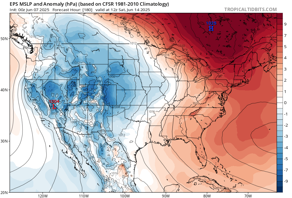
The deep red is the higher pressure than normal. This leads to easterly flow here once the back door drops south. The EPS is forecasting a stalled out front to be somewhere south of us mid-June. Once waves of low pressure start to ride east it will eventually lead to the rains coming back north into our area mid-June. But maybe we can sneak in a dry weekend for a change.
-
paradoxically, CC may cause ocean effect snow to increase for the Cape and Islands?
-
67 and humid feeling, overcast from wildfire smoke aloft.
-
Chris whats that giant High in eastern Canada doing in the first map, all that deep red up, what are the temperatures under that?
-
Looks like it could be pretty nice next Saturday at the moment...hoping that holds for backyard grad party.
-
Eastern areas should be ok for awhile today
-
It’s NNE warm season baby. Haven’t even entertained being up there yet.
-
No showers here at all just foggy and 100% humidity and yucky 70 degrees. I don't know why some people go by the temperatures, 100 degrees with a 58 dew point and 25% humidity is MUCH more comfortable than this mess I turned on the air conditioner as soon as I woke up. No a/c needed with 100 degrees and 58 dew point and 25% humidity, this weather is so much worse!
-
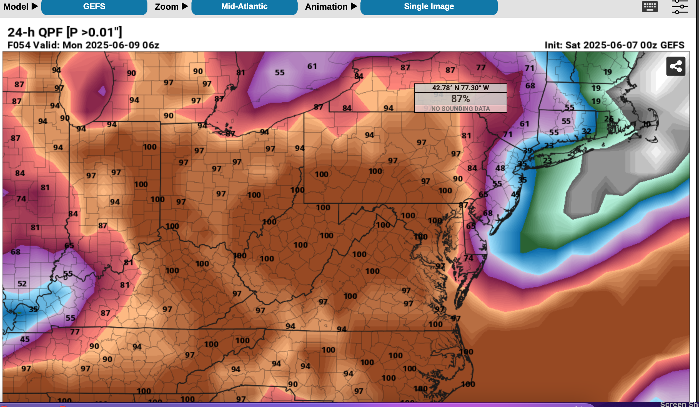
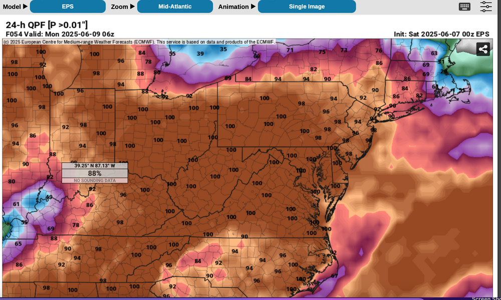
Looks wet at times, daily through Tue... added the Prob of >0.01 from wet 00z/7 EPS and drier GEFS. I wouldn't promise anyone a dry Sunday afternoon-night... just by natural, albeit weakening northeastward ejection of the lead short wave, I would think rain would impact. our area later Sunday. When to mow if you didnt yesterday... for me up here, window of opportunity 4P today to 2P Sunday. Attached probs. Next chance of 90 interior seems next Thu-Fri though ensembles dont play it up. Very rapid warming again after the trough aloft our area Tue-Wed lifts northward, similar to this past Wed-Fri. Will add first week CF6 for Newark tomorrow morning.

-

2025 Lawns & Gardens Thread. Making Lawns Great Again
jbenedet replied to Damage In Tolland's topic in New England
https://rohrerseeds.com/products/st-gabriel-holy-moley-mole-repellent-10-lb?srsltid=AfmBOoqHunpQHPlH-DlrQqHVxYH_03x1GrCW_Nrmma3Bi4KuyIcXya_c Neighbor put this down last year with pretty good success. -
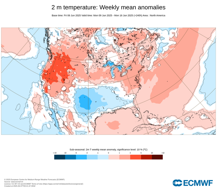
We are starting out with fog here today with showers across the area. Then we dry out tomorrow morning before more rain later in the day into the evening. So our first major 95° heat and first 90° east of NYC will have to wait. Longer range it looks like a back door pattern for next weekend with strong Canadian high pressure. Maybe the high will be strong enough to keep the stalled front and rains closer to DC and south. Would be nice to get a dry weekend with comfortable June temperatures. The strongest heat is forecast to stay to our West through mid-June.

-
My pointing out a particular repeating pattern over time with our storm tracks leading to less snow is more about pattern recognition on my part. I use it in real time to point out that the models have been too snowy beyond 5 days. This has lead to the famous modeled snowstorm always being a week a way. Which is due to the models underestimating the influence of the Pacific Jet longer range. Adding extra warmth to the system in multiple locations causes shifts in the storm tracks. So we need to acknowledge this as a forecast aid.
-
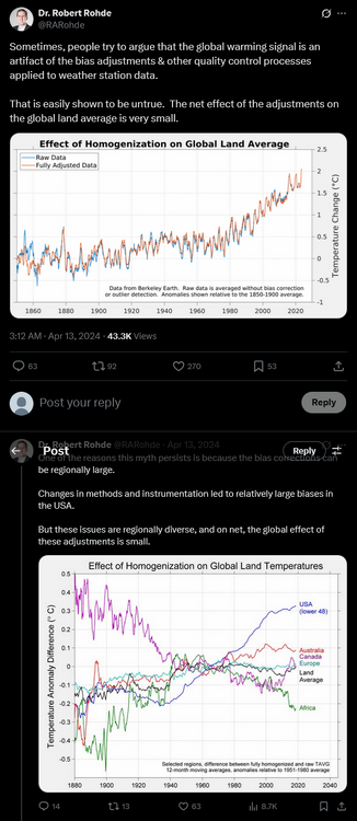
A reminder that adjustments to temperatures in the US, 6% of the world, don't matter. https://x.com/RARohde/status/1779044943501152416
-
Shewchuk is telling us something we already know: raw COOP data in the US is biased. We've known this for decades. Deniers have been making the same complaint for decades; but they haven't provided a single document in a scientific forum to back up their claims. As we have found out in Chester County, NOAA's adjustments are completely justified. Stations moved, sensors/shelters ran warm, etc. Every time we checked, the raw data at nearby stations verified the adjustment. At this point you might as well complain that the sky is blue or the world is round.
-
Morning Don,
Noticed no MO projection for June? Too uncertain?
Probably no skill determining which summer month might be warmest departure?
Checking in,
Walt
-

Chester County PA - Analytical Battle of Actual vs. Altered Climate Data
chubbs replied to ChescoWx's topic in Climate Change
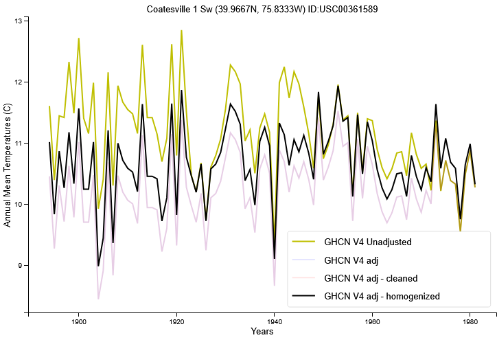
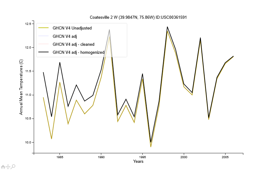
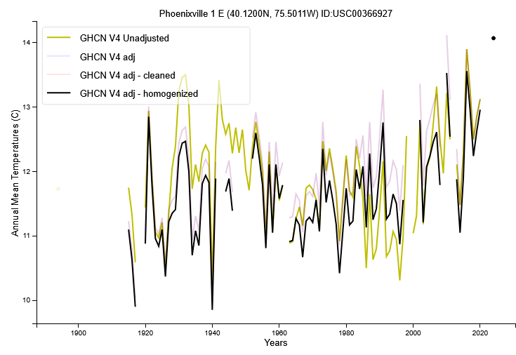
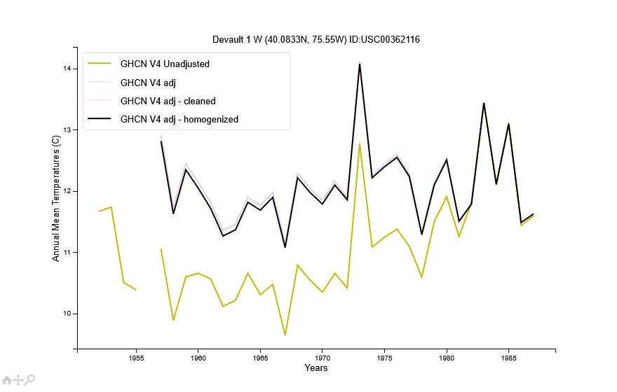
You are spouting conspiracy theory mumbo jumbo. The adjustments all come from the raw data. The two big moves are by far the biggest adjustments in Chester County. Completely justified as we have seen. Let's go through the adjustments in detail. The West Chester move in 1970 triggers large adjustments before the move. 70+ years of large warm adjustments that are completely justified in the raw data. The other west Chester adjustments are relatively minor. Not that when the West Chester adjustment is less than 2F in the pre-move period it is a cooling adjustment relative to the warm town baseline. Coatesville1sw is similar to Coatesville with the 1946-47 moves being the main adjustment. Again completely justified. Coatesville 2W gets a small cooling adjustment. Phoenixville gets a warm adjustment in the 1930-1950s period. Again completely justified. Other than that the adjustments are minor. Like Coatesville 2W, Devault gets a warming adjustment. The bottom-line is that the major Chesco Coop adjustments are completely justified. The other Chesco adjustments don't impact the long-term climate trend as they are: smaller, shorter duration, and go both ways. You have complained for over a year about a scientific method you don't understand. During that time you haven't provided any evidence to back up your claims. On the contrary, the County adjustments that we have looked at are all completely justified by the raw data. Coatesville and West did have major cooling moves. Phoenixville did run warm in the 1930-50s. Your complaint boils down to the fact that you don't like the answer. What about this adjustment, What about that adjustment. That doesn't move the needle. You need to look at the raw data that triggered the adjustment. Telling us that there adjustments that you don't like doesn't move the needle. Science isn't going to change because you don't like the answer.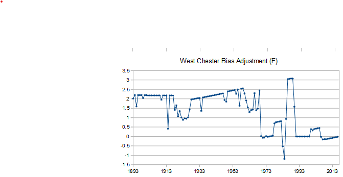
- Today
-
Is it too much to ask to string some steiny days together ? This doesn't look to be the week. Key Messages: * Scattered showers and cooler temperatures Monday and Tuesday * Clearing Wednesday into Thursday with highs reaching the low to mid 80s. And then of course for the weekend: "Unsettled conditions return heading into the weekend, bringing more chances for showers."
-
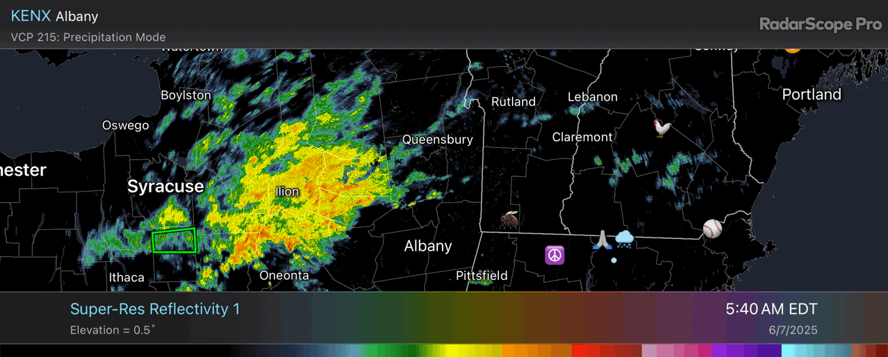
Yep. The HRRR depicts that pretty well.