All Activity
- Past hour
-

October Comes Early: Late September Multi-Hazard Hybrid Storm
WinterWolf replied to WxWatcher007's topic in New England
Hailstoned hailstoned groan and boned…. -

October Comes Early: Late September Multi-Hazard Hybrid Storm
vortex95 replied to WxWatcher007's topic in New England
40-48 hr the 00z HRRR shows it taking on more ST characteristics w/ a more focused core wind field. RRFS does this but it take more than 24 hr after this time, and the low just meanders around to the S of us for the entire 84 hr period! Lots of time to do odds stuff! @WxWatcher007 I know will be closely tracking the exact sfc low position relative to the SSTs!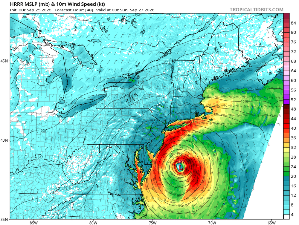
-
Get them here! https://www.ncei.noaa.gov/gibbs/
-
2026 Atlantic Hurricane Season
vortex95 replied to Stormchaserchuck1's topic in Tropical Headquarters
00z HRRR shows the E Coast low taking on more ST characterists 40-48 hr as a inner core contracted wind field develops. RRFS it take over 24 hr longer to do this.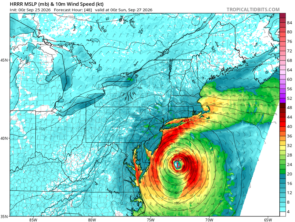
-

October Comes Early: Late September Multi-Hazard Hybrid Storm
DirtySnowDen replied to WxWatcher007's topic in New England
I’m thinking a soft, yet strong landfall on LI, doing its dance and meandering around BIS as it kaboots in its feeble state Monday. -
I got to give you props for pulling up this old satellite image!
-

October Comes Early: Late September Multi-Hazard Hybrid Storm
Hailstoned replied to WxWatcher007's topic in New England
trumpy, trumpy temper tantrum... -
October Comes Early: Late September Multi-Hazard Hybrid Storm
DirtySnowDen replied to WxWatcher007's topic in New England
Yes. -
October Comes Early: Late September Multi-Hazard Hybrid Storm
vortex95 replied to WxWatcher007's topic in New England
On Wed, five sites in ME/Quebec set all-time record high pressures for Sep. @CoastalWx take note. It's an exceptional pattern! Frenchville Montreal Quebec City Val D’Or Chibougamau-Chapais. -
October Comes Early: Late September Multi-Hazard Hybrid Storm
WinterWolf replied to WxWatcher007's topic in New England
You’re talking about the High? -
October Comes Early: Late September Multi-Hazard Hybrid Storm
DirtySnowDen replied to WxWatcher007's topic in New England
Last post for the night; it’s looking worse and worse for us. All depends on if it does a 50/50 split or a 40/60. -
 online medicine shopping [url=http://geninduspharma.com/#]buy medicines online[/url] online chemists
 -
Berlin mesonet site had a peak gust of 36 mph earlier today. Will be interesting to see how this storm plays out this weekend. Hope it's a sign of a decent winter incoming.
-

October Comes Early: Late September Multi-Hazard Hybrid Storm
Spaizzo replied to WxWatcher007's topic in New England
Next to the butt cheeks se of obx? . -

October Comes Early: Late September Multi-Hazard Hybrid Storm
Diggiebot replied to WxWatcher007's topic in New England
Winter storms we wait for the ticks east on game day -
Just a nit from the 25/03z discussion for Nolo: Nolo is expected to pass near or just south of the Big Island of Hawaii on Saturday as a major hurricane. It's closet approach is about 125 mi S of the srn tip of the Big Island. Is that really "near or just S" for such a distance, esp. for an avg size TC? The wording makes it sounds closer than it really will be. That's a big deal when it comes to winds in a TC, esp. a strong one.
-
.thumb.gif.f92b16c631a1d15d405ed77b33f0710d.gif)
October Comes Early: Late September Multi-Hazard Hybrid Storm
Torch Tiger replied to WxWatcher007's topic in New England
Love the RGEM track, basically Sandy -lite -
October Comes Early: Late September Multi-Hazard Hybrid Storm
Torch Tiger replied to WxWatcher007's topic in New England
0z NAM touches 979mb around 80-100mi south of LI -
North OC here. It’s quite windy In OC for it lol
-

Strong Nor'Easter/Hybrid Storm Late September 2026
wthrmn654 replied to Rjay's topic in New York City Metro
Rgem just goes due west under long island and dies in New Jersey. -
Strong Nor'Easter/Hybrid Storm Late September 2026
wthrmn654 replied to Rjay's topic in New York City Metro
Icon looks a bit west. Good looks like it's going be fun at work the next few days. Back to laundry and sleep, maybe -

Strong Nor'Easter/Hybrid Storm Late September 2026
TriPol replied to Rjay's topic in New York City Metro
Both the GFS and EURO have shown this. It'll be fascinating to watch in real time. Like a strong hurricane hurricane wobbles, this storm will do the same. -

E PA/NJ/DE Autumn 2026 Obs/Discussion
PhiEaglesfan712 replied to PhiEaglesfan712's topic in Philadelphia Region
I have a flight at PHL on Saturday night to Italy. I hope the storm holds off until at least then. If it doesn't, I might be stuck there for a while. -
Strong Nor'Easter/Hybrid Storm Late September 2026
wthrmn654 replied to Rjay's topic in New York City Metro
The rgem run reminds me a lot like those tops you would spin as kids, random and wonky patterns... it's just doing loop de loops up the east coast. -
Strong Nor'Easter/Hybrid Storm Late September 2026
wthrmn654 replied to Rjay's topic in New York City Metro
The one Mesomodel in testing came way west with precip area wide now. I think we have a concesus finally with minor details to iron out