All Activity
- Past hour
-

2025-2026 ENSO
40/70 Benchmark replied to 40/70 Benchmark's topic in Weather Forecasting and Discussion
I highly doubt a PNA that biased towards negtive, but we'll see. -

September 2025 OBS-Discussion centered NYC subforum
wdrag replied to wdrag's topic in New York City Metro
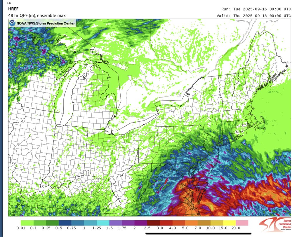
12z/16 RDPS - RGEM starts out much better than the NAM suite-RAP. So for me planning I80 north... some sort of cross between 12 HRRR/RGEM. Even SPC HREF from 00z/16 cycle sees too far s this morning and the max missed the 1" at Cape May as seen on the NJ CLIMAT web site. -
2025-2026 ENSO
40/70 Benchmark replied to 40/70 Benchmark's topic in Weather Forecasting and Discussion
Okay....if that is the case, it would seem a warmer version of 2013-2014 adjusted for CC is a perfectly a viable option. -
Toeing the wedge but the phase diagrams seem to agree

-

2025-2026 ENSO
PhiEaglesfan712 replied to 40/70 Benchmark's topic in Weather Forecasting and Discussion
If we go la nina, I still like 1949-50 as the best analog. I'll even adjust it for climate: Sorry in advance if we get a torch January and a low snow winter.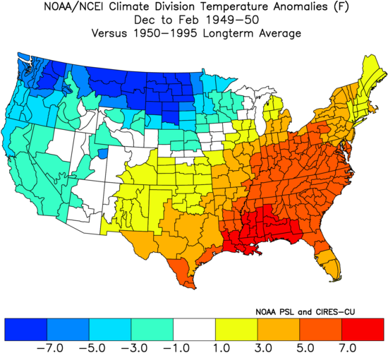
-
There are none. That’s why I don’t like using them
-
2025-2026 ENSO
40/70 Benchmark replied to 40/70 Benchmark's topic in Weather Forecasting and Discussion
Don, can you do me a favor and let me know how many analogs you have that are a 100% match? Thanks. -
2025-2026 ENSO
40/70 Benchmark replied to 40/70 Benchmark's topic in Weather Forecasting and Discussion
Which is all the QBO difference means. -
I have no doubt that the SPV will be weaker this winter than 13-14 was. That was the most positive AO and NAO in history
-
2025-2026 ENSO
40/70 Benchmark replied to 40/70 Benchmark's topic in Weather Forecasting and Discussion
Probably a weaker PV this year then....winter cancel. Honestly though, you have this habit of dispelling analogs due to random differences. -
Perhaps you should start.
-
https://www.outerbanks.org/plan-your-trip/webcams/ OBX webcams. Surfs up!
-
That winter was also raging positive QBO
-

2025-2026 ENSO
donsutherland1 replied to 40/70 Benchmark's topic in Weather Forecasting and Discussion
It seems that 2013-14 is a popular analog on social media right now. That the North Pacific SSTs are not similar to those of 2013-14 doesn't phase those speculating. Right now, if the anomalies stay as is, one would be dealing with a weaker Aleutian Low, which teleconnects to milder conditions in the East. Should dual areas of excessive warmth persist, there could be some variability, but again not the kind of consistent cold seen during winter 2013-14. We'll see how things evolve in coming months. -

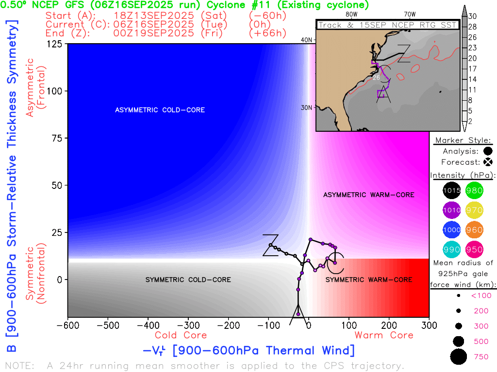
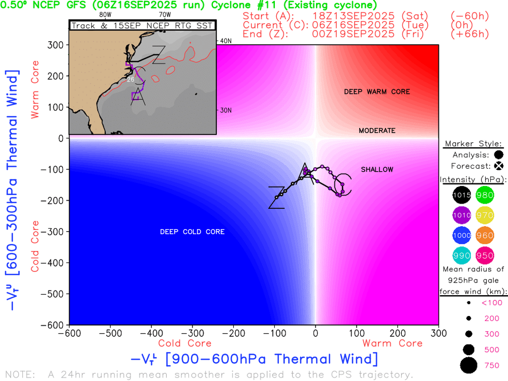
2025 Atlantic Hurricane Season
NorthHillsWx replied to BarryStantonGBP's topic in Tropical Headquarters
Great analysis. I said this on the Southeast board, but folks rushing to name this haven’t seen a proper nor Easter in awhile! It’s a textbook nor Easter and if you look at Water Vapor loop you can see it’s part of a larger ULL centered over the western Carolina’s. Also agree, if this was south of hatteras and over warmer water for longer, you could see it “pinch off” and wrap up into a hybrid system but this is fully frontal at the moment and a very powerful nor Easter. Jennettes pier has now gusted to 65 mph and has recorded gusts over 45 kts for the third straight day. Very impressive system but not tropical -
Yeah its like half brown/ green even on the same branches. that makes more sense.
-

2025 Atlantic Hurricane Season
WxWatcher007 replied to BarryStantonGBP's topic in Tropical Headquarters
Totally agree with Andy. The only real shot of continental US impacts at this point would come from homebrew off the coast/Gulf or from the Caribbean. -
Keep learning
-
2025 Atlantic Hurricane Season
NorthHillsWx replied to BarryStantonGBP's topic in Tropical Headquarters
https://x.com/andyhazelton/status/1967948009901109559?s=46&t=NyKvXvI1o-sJQb-68mmo4g -
Pretty good radar depiction right now of the coastal low.
-
Rain and wind in Calvert right now. Got pretty wet driving my motorcycle to the gym and then work.
-
I do not think this is subtropical. It is fully attached to a front and I see no evidence of a warm core, just warm air on eastern side south of a warm front. Also if you watch water vapor loop it is within a broader upper level system centered over WNC. These nor Easter’s can be quite strong and prolonged, as evidenced by winds gusting above 50 on the OBX for the third straight day. The folks jumping on naming this haven’t seen a proper nor Easter in a while! These are fun systems to watch
-
2025 Atlantic Hurricane Season
WxWatcher007 replied to BarryStantonGBP's topic in Tropical Headquarters
It’s over increasingly marginal SSTs and doesn’t have a lot of time before it’s either onshore or tucked into the coast. If that boundary weren’t so clear I’d say it has a solid chance of subtropical development, but I just think this one isn’t going to get there. I don’t think the NHC would pull the trigger on that. Not this year at least with them missing/slow to designate two TCs this season. If this were off of Wilmington, I think it’d be a different story given SSTs. It’s firing good convection, but you really want to see it over the center. On radar though the presentation is actually pretty nice with some spiral banding evident. Worth a casual eye in case my analysis is wrong lol. -

September 2025 OBS-Discussion centered NYC subforum
bluewave replied to wdrag's topic in New York City Metro
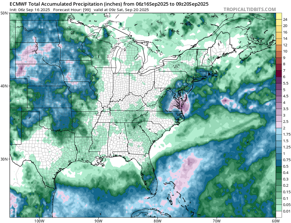
You know it’s a dry pattern when the main interest is how close the .50 line gets to NYC.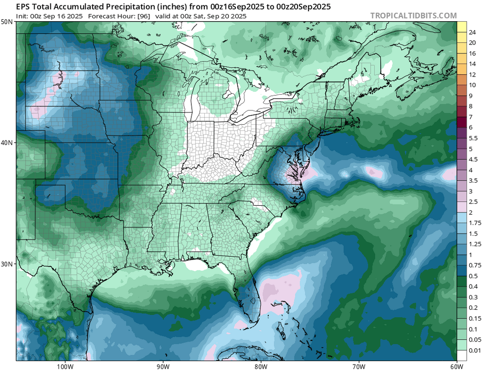
-
Another dry day over here in W. Central MD. Have noticed an early corn harvest this year. The field behind my house is done, has been for about a couple of weeks. On our walk this past weekend you could see where you would have no problem crossing parts of the Potomac on foot to certain islands. Very shallow in many places. I know weather gets into patterns seems we have been stuck in one for about 3 years now over here. Many days where I have watched hopeful rain coming in only to see it hit the dry dome. Have had a bit more storms break through this year than past. But looking at my weather station have not had any rain since 9 days ago. Rain for me gives a feeling of refresh. And I need a refresh. Going to make some apple crisp now.