All Activity
- Past hour
-

"Don’t do it" 2026 Blizzard obs, updates and pictures.
ineedsnow replied to Ginx snewx's topic in New England
just had a hell of a gust when I was outside.. loud crack then boom.. something big fell -
Area Forecast Discussion National Weather Service New York NY 341 AM EST Mon Feb 23 2026 .WHAT HAS CHANGED... There have been no changes to headlines and only some adjustments to snowfall, mainly over western portions of the Lower Hudson Valley. && .KEY MESSAGES... 1) Blizzard conditions will continue through the morning hours, gradually winding down in the afternoon. 2) Additional minor coastal flooding possible with the Monday afternoon high tide cycle. There is a low probability of major coastal/shoreline impacts along the south shore of western Long Island, Twin Forks of LI, and north shore of Long Island. 3) A passing warm front will bring some light snow and rain on Wednesday. A stronger low passing close by will bring additional wintry precip Thursday into Thursday night. && .DISCUSSION... .KEY MESSAGE 1... A major winter storm will continue to impact the area early this morning with multiple bands of heavy snow expected to pivot NW off the ocean and across the area. The next 6 hours are expected to feature some of the heaviest snowfall with hourly rates of 2 to 3 inches likely. What is a bigger challenge is exactly how far west these bands get and how long they stay over a particular location. Outside of these bands, there is subsidence and lighter snowfall. Much of the area has seen anywhere from 7 to 14 inches, but there were lower amounts across northern and western portions of the Lower Hudson Valley. We can expect another 6 to 12 inches, much of which will come the next 6 to 9 hours. The back edge across western Orange County looks like it will be on the low end, perhaps another 4 inches. Hires guidance pointing to this area to be along the back edge in the subsidence of the storm. In addition, don`t be surprised to see a brief flash of lightning in the heavy bands. There have been reports from the public as well from lightning detection. As the storm pulls away late this morning into the afternoon, bands on the backside will dissipate, but it could take some time. Hires guidance locking on to an area from eastern portions of the Lower Hudson Valley and SW CT southward in the NYC/NJ metro. These bands in past historic storms can often be areas of exceptionally high rates, but can be a challenge to forecast. Any lingering snow bands should dissipate by early evening. The wind forecast has changed little with peak winds being this morning into early this afternoon. Gusts of 40 to 60 mph can be expected through the morning hours, with the upper end across far eastern LI and SE CT. Winds will then gradually ramp down through the afternoon into the evening. The good news is the airmass is not exceptionally cold with highs around freezing for most locations. Wind chills values will be in the teens to around 20.
-
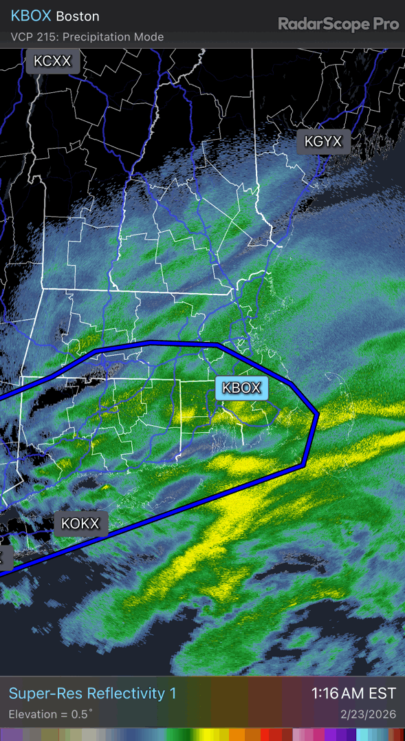
dang that band is nice. I think I must be in a narrow band that is coming through northern westchester right now, which has been impressive. I was going to go to bed, but I have to stay up now to see if we get into that band coming across LI. Looks like there is thunder in there as well.
-

"Don’t do it" 2026 Blizzard obs, updates and pictures.
Baroclinic Zone replied to Ginx snewx's topic in New England
Noted a pair of distinct bands already formed. One from eastern Long Island to the south coast of MA/RI that appears to be associated with deep frontogenesis in the 925-700 mb layer. Thinking this band stays just southeast of the I-95 corridor between Boston and Providence through mid morning, before pivoting farther west into the late morning and afternoon. The second band looked to be driven by a frontogentical band in the 850-700 mb layer, so not quite as intense but enough to lead to localized enhancement of snowfall. This second band shifts east through this afternoon as the offshore low pressure moves away from our region. -
The bronx has multiple reports of between 14 to 17 inches down. Its coming down so hard rn.. you can hear it. 20 inches is right around the corner,also temp has dropped to 28f.
-
"Don’t do it" 2026 Blizzard obs, updates and pictures.
Baroclinic Zone replied to Ginx snewx's topic in New England
-

"Don’t do it" 2026 Blizzard obs, updates and pictures.
Ginx snewx replied to Ginx snewx's topic in New England
Wow its zero vis.thumb.png.32eb0841d7e163f585debbed67125da9.png)
-
BUCKLE UP!

-

"Don’t do it" 2026 Blizzard obs, updates and pictures.
weatherwiz replied to Ginx snewx's topic in New England
LET'S GO!! -

"Don’t do it" 2026 Blizzard obs, updates and pictures.
dendrite replied to Ginx snewx's topic in New England
There’s the demon
-
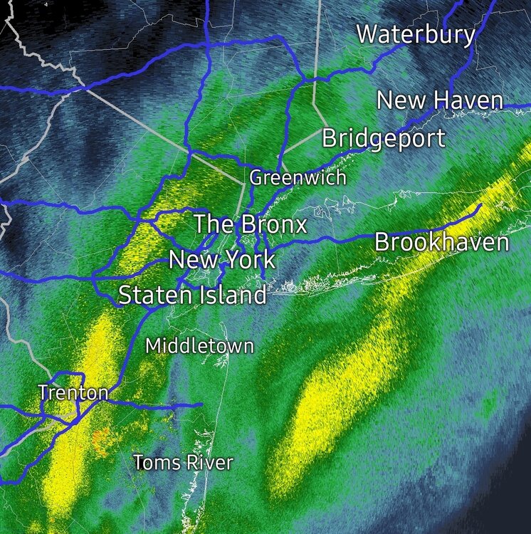
These bands are gonna merge I think… the metro and Long Island gonna get destroyed
-
"Don’t do it" 2026 Blizzard obs, updates and pictures.
Baroclinic Zone replied to Ginx snewx's topic in New England
This band is gonna rock.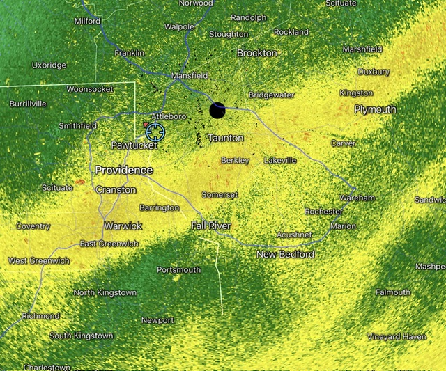
-
FULL ON BLIZZARD in Copiague under that band that will bury the island. Holy cow.
-

"Don’t do it" 2026 Blizzard obs, updates and pictures.
Bryan63 replied to Ginx snewx's topic in New England
We are getting rocked!! Even between gusts it's difficult to make out much across the street. -

"Don’t do it" 2026 Blizzard obs, updates and pictures.
FXWX replied to Ginx snewx's topic in New England
54 mph gust here just now -
just went outside on my covered porch. Though we face west-east. I am a snow man after 10 minutes being outside with the wind driven snow coming from the north blowing under the porch roof. It is dumping. It is a blizzard in terms of visibility. Forget a 1/4 mile. I could sometimes barely see 100 ft.
-
.thumb.jpg.6a4895b2a43f87359e4e7d04a6fa0d14.jpg)
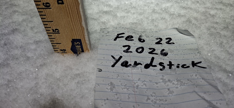
Central PA Winter 25/26 Discussion and Obs
Yardstickgozinya replied to MAG5035's topic in Upstate New York/Pennsylvania
Down to just a few danderites. 1.25" on my second measurement, for a total of 5.25"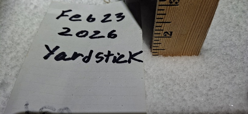
-
"Don’t do it" 2026 Blizzard obs, updates and pictures.
weatherwiz replied to Ginx snewx's topic in New England
102K w/o power in NJ -
Not gonna lie, this one stings. Knowing what is just 50 miles to our west. Also the rug pull that was the last 24 hours of modeling for western spots. We may have 4" or 5". Can't even tell if it's still snowing by looking at the street lights. Roads are just wet lol. Stoked for those of you getting raked. Ill live vicariously through you guys. That band over Philly has got to be amazing. Enjoy! Sent from my SM-S938U using Tapatalk
-

"Don’t do it" 2026 Blizzard obs, updates and pictures.
Roger Smith replied to Ginx snewx's topic in New England
Nantucket 54SE buoy reports ENE 43 kt g 54 kt, 38F, 983 mbs and 18' wave heights ... the deepening (!) low will track just south of that location in about six or seven hours. That would suggest the 50-60 mph winds will be pushed up over southeast MA around that time, and could increase to 60-80 mph. There are going to be some brutal conditions in eastern MA, RI and se CT between now and about noon, If you don't already have this bookmarked, here you go ... NDBC - Station 44008 Recent Data -
Thanks! I guess we'll see how it goes. I have to back in off of Koffel Road which is dicey when it's dry and the sun shines. Not sure what it'll be like today.
-
"Don’t do it" 2026 Blizzard obs, updates and pictures.
ineedsnow replied to Ginx snewx's topic in New England
Recon out.. maybe we can get a actual pressure reading on this thing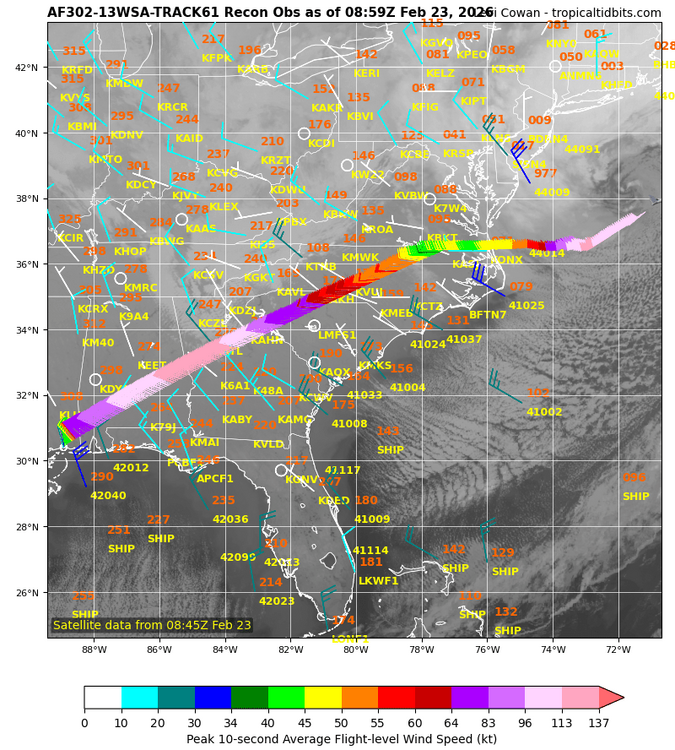
-

"Don’t do it" 2026 Blizzard obs, updates and pictures.
BIsound replied to Ginx snewx's topic in New England
RI south coast. Power out at 3:30am. Shoveled around generator. RI Energy text says 1600 impacted in my area -

"Don’t do it" 2026 Blizzard obs, updates and pictures.
The 4 Seasons replied to Ginx snewx's topic in New England
yeah we've been torch-erd here watching New London and Middlesex get smoked with 18-30" storms over and over the past 10 years.

-
"Don’t do it" 2026 Blizzard obs, updates and pictures.
Thunderblizzard replied to Ginx snewx's topic in New England
Getting hard with everything blowing and drifting now... going with 9.5" as of 4:00 AM. Blizzard conditions.


.png.89fb7c6cba58f961ddbadb00b9b3ac9c.png)