All Activity
- Past hour
-

“Cory’s in NYC! Let’s HECS!” Feb. 22-24 Disco
metagraphica replied to TheSnowman's topic in New England
32/30. Light snow/drizzle for the past couple of hours. Some kind of weird low level precip.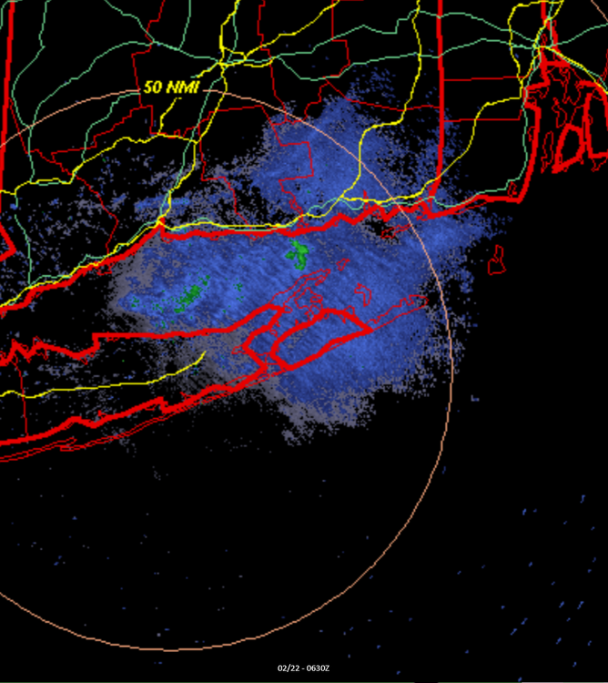
-
much lower in certain areas especially the ocean county coast VS. the NAM
-

“Cory’s in NYC! Let’s HECS!” Feb. 22-24 Disco
WxWatcher007 replied to TheSnowman's topic in New England
Not that it matters at this point but here is the EPS. 12z 00z -
12/30/00 was sure as hell no change to sleet and that must've been 4" per hour when it was the once I heard thundersnow. Was literally blinding heavy snow. The rain line wasn't too far east in Suffolk County, Long Beach lucked out for once that day.
-

“Cory’s in NYC! Let’s HECS!” Feb. 22-24 Disco
WeatherGeek2025 replied to TheSnowman's topic in New England
stupid ai can't translate numbers sorry about that. -
“Cory’s in NYC! Let’s HECS!” Feb. 22-24 Disco
WxWatcher007 replied to TheSnowman's topic in New England
When I saw the names on the other one I lost it -
RWR from KCTP
-
Is that stuff in central pa hitting the ground?
-
Dry slot, boundary layer warms to mixed precip, storm track much further east of benchmark.
-

Feb 22nd/23rd "There's no way..." Obs Thread
stormtracker replied to Maestrobjwa's topic in Mid Atlantic
See you on the flip side. Good luck -
They usually end up further NW than forecast
-

“Cory’s in NYC! Let’s HECS!” Feb. 22-24 Disco
40/70 Benchmark replied to TheSnowman's topic in New England
I like it for here....15-16" is a good guess, but too light in ORH county and S NH. -
“Cory’s in NYC! Let’s HECS!” Feb. 22-24 Disco
WeatherGeek2025 replied to TheSnowman's topic in New England
i have the original one but people complained it was too bright
-

“Cory’s in NYC! Let’s HECS!” Feb. 22-24 Disco
bristolri_wx replied to TheSnowman's topic in New England
.thumb.png.f8891ebc5930139c87a5a0daf6c48413.png)
-
“Cory’s in NYC! Let’s HECS!” Feb. 22-24 Disco
40/70 Benchmark replied to TheSnowman's topic in New England
Too bad he wouldn't check out Telerican Weather and spend some time on that site. -

Feb 22nd/23rd "There's no way..." Obs Thread
ravensrule replied to Maestrobjwa's topic in Mid Atlantic
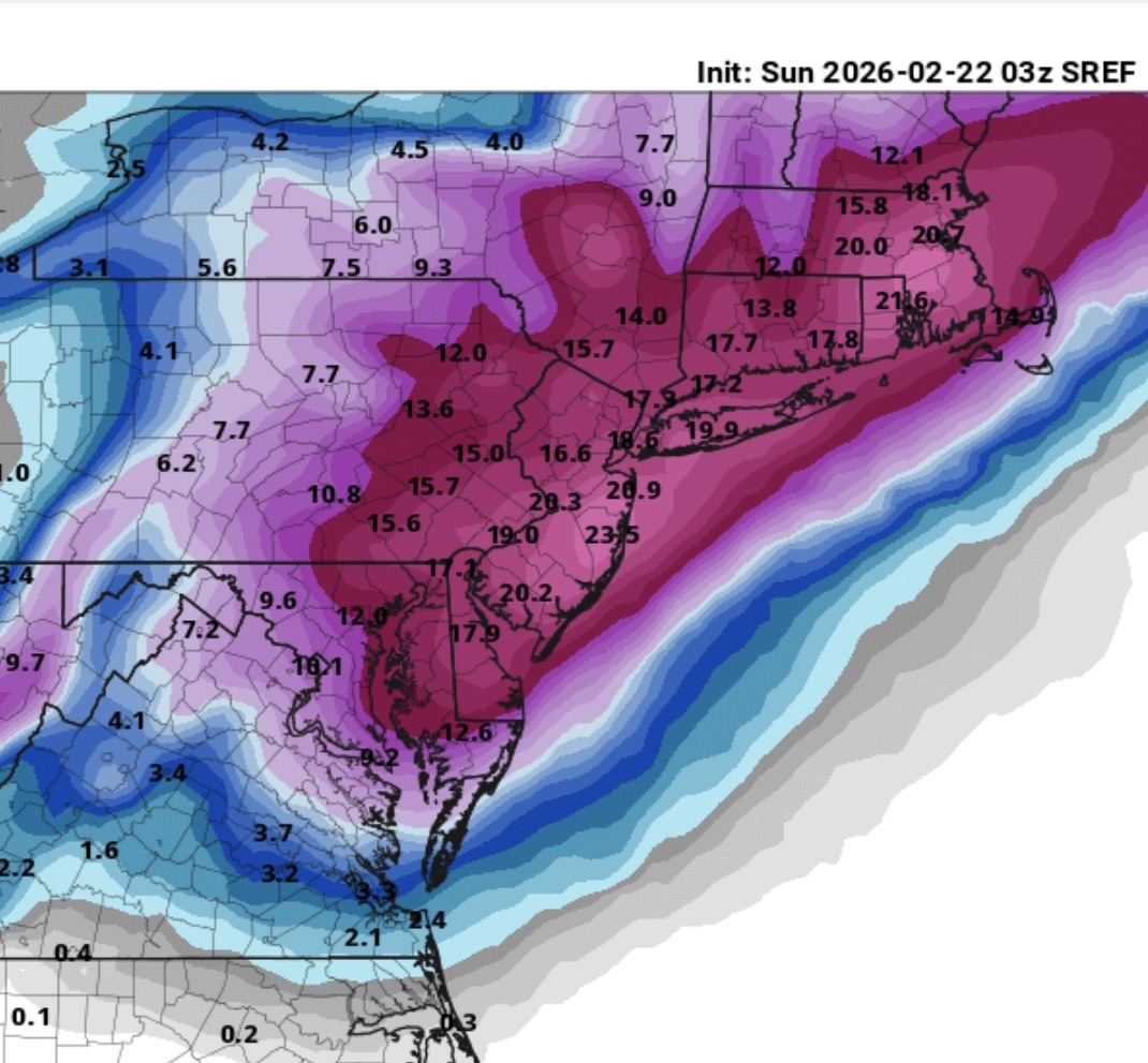
The Sref not as good as the last one.
-
Sref is very consistent

-
Snowfall rates can jackpot with thunder snow. Though I have seen it go either way. Either heavy snow, or a change to sleet!
-
Feb 22nd/23rd "There's no way..." Obs Thread
ravensrule replied to Maestrobjwa's topic in Mid Atlantic
1,000%, terrible job. We miss you Randy, please come back. -

Feb 22nd/23rd "There's no way..." Obs Thread
Silver Meteor replied to Maestrobjwa's topic in Mid Atlantic
The Low is forming now on the Carolina Coast: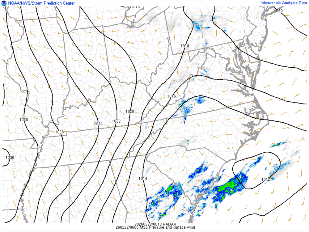
-
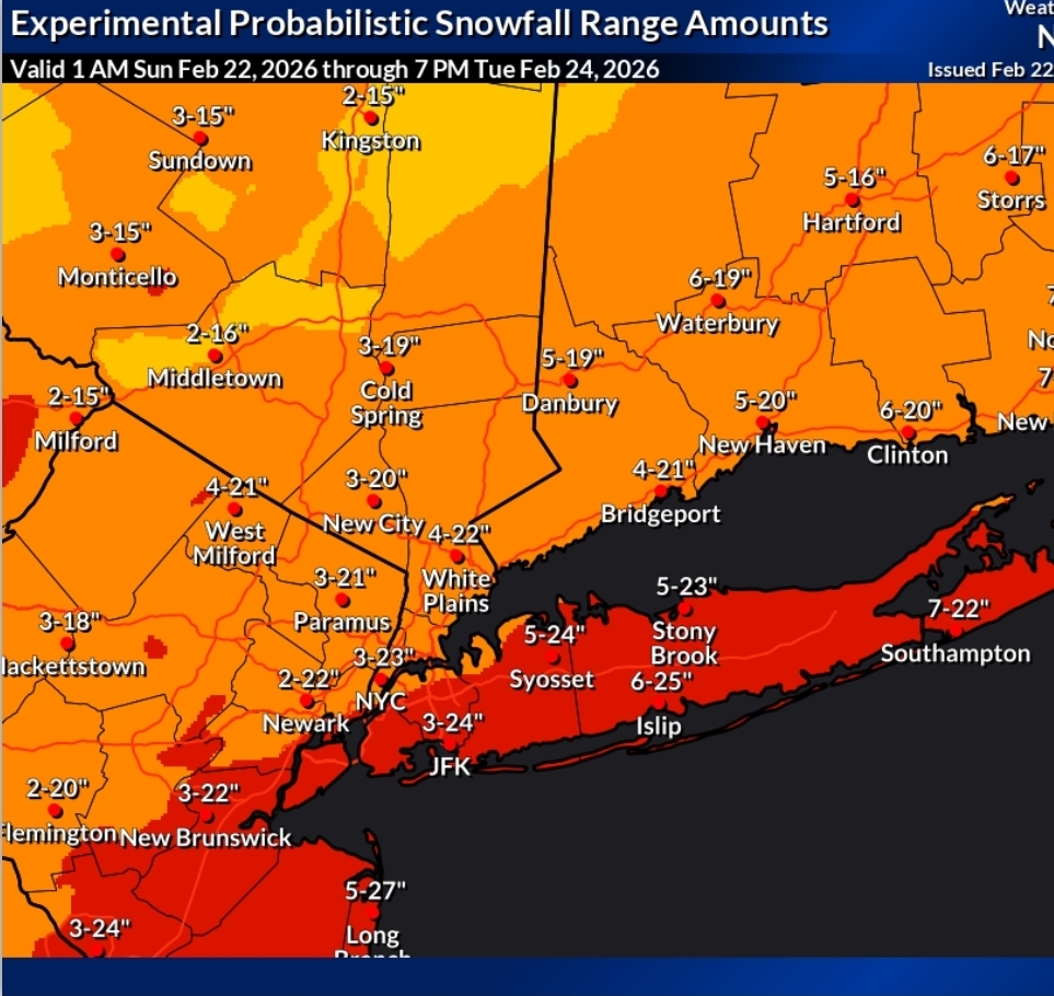
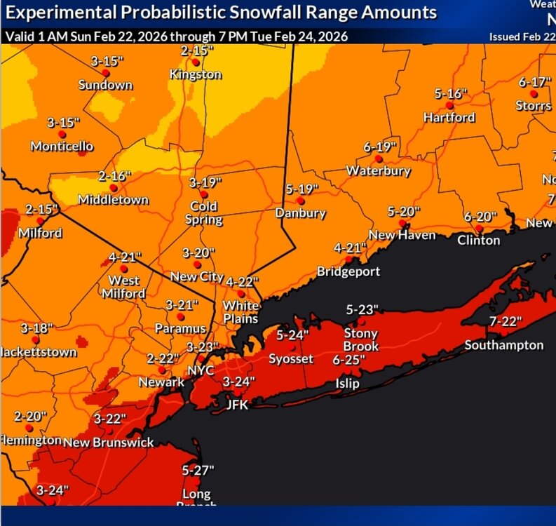
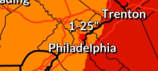
Upton hedging with 3-23" lol Mt. Holly has a crazier 1-25" for Philadelphia
-
You really should check out Darfford this time of year.
-
Feb 22nd/23rd "There's no way..." Obs Thread
stormtracker replied to Maestrobjwa's topic in Mid Atlantic
You’re fired. -
My question now is what is everyone's opinion on what could go wrong with this storm causing much lower snowfall amounts then modeled in certain areas ? One area I think that is overdone is the NAMS 42 inches on the Ocean County coast .
-
That low does NOT want to move wow


.png.d177b9af340b8c608cec3da2a61c015e.png)