All Activity
- Past hour
-
It would fix your acorn problem.
-
And no power for two weeks. If/when we do get hit it will be funny to listen to people bitching about power being out for 24hrs never mind a week+!
-
Glad we here
-

Eastern Tropical Atlantic Wave - 0/40
GaWx replied to BarryStantonGBP's topic in Tropical Headquarters
0Z UK had it again and it’s stronger (TS) though it’s further N:NEW TROPICAL CYCLONE FORECAST TO DEVELOP AFTER 132 HOURSFORECAST POSITION AT T+132 : 22.0N 54.6WLEAD CENTRAL MAXIMUM WINDVERIFYING TIME TIME POSITION PRESSURE (MB) SPEED (KNOTS)-------------- ---- -------- ------------- -------------1200UTC 14.08.2025 132 22.0N 54.6W 1010 300000UTC 15.08.2025 144 23.3N 57.2W 1009 301200UTC 15.08.2025 156 25.5N 59.1W 1007 410000UTC 16.08.2025 168 26.8N 61.6W 1006 44 -
Looks like gfs
-
Not that far. I'd like to see that one. Everyone getting their panties and a bunch and then wide right.
-
Euro AI far and away OTS
-
Still too far east for most of us
-
I know the low is over the cape, but I’ll take 8-10” of rain and 70mph winds.
-
After this, I got several more rounds of rain through the evening of 7/8 adding to that gotten yesterday afternoon adding up to a total of ~1.3”. After emptying that, I then through the early morning hours (7/9) received heavy showers coming off the ocean with the heaviest 5-5:30AM. I estimate 2” from the late night through now (7:40AM) with light rain still falling. All of this is on top of the 6” I got Aug 1-6! So, I’m at ~9.3” Aug 1 through 7:40AM of Aug 9!My water table is ridiculously high. Fortunately though due to the rains being spread out enough, I’ve yet to have any garage flooding this month despite heavy puddling of rain sitting just outside the garage. However, more heavy rains are possible over the next few days.Not one but two flash flood warnings were up for the county since late afternoon yesterday (8/8)!#1:BULLETIN - EAS ACTIVATION REQUESTED FLASH FLOOD WARNING NATIONAL WEATHER SERVICE CHARLESTON SC 353 PM EDT FRI AUG 8 2025 THE NATIONAL WEATHER SERVICE IN CHARLESTON HAS ISSUED A * FLASH FLOOD WARNING FOR... CHATHAM COUNTY IN SOUTHEASTERN GEORGIA... * UNTIL 700 PM EDT. * AT 353 PM EDT, DOPPLER RADAR INDICATED THUNDERSTORMS PRODUCING HEAVY RAIN ACROSS THE WARNED AREA. BETWEEN 1.5 AND 2.5 INCHES OF RAIN HAVE FALLEN. ADDITIONAL RAINFALL AMOUNTS OF 1 TO 2 INCHES ARE POSSIBLE IN THE WARNED AREA. FLASH FLOODING IS ONGOING OR EXPECTED TO BEGIN SHORTLY. HAZARD...FLASH FLOODING CAUSED BY THUNDERSTORMS. SOURCE...RADAR INDICATED. IMPACT...FLASH FLOODING OF SMALL CREEKS AND STREAMS, URBAN AREAS, HIGHWAYS, STREETS AND UNDERPASSES AS WELL AS OTHER POOR DRAINAGE AND LOW-LYING AREAS. * SOME LOCATIONS THAT WILL EXPERIENCE FLASH FLOODING INCLUDE... POOLER, DOWNTOWN SAVANNAH, HUTCHINSON ISLAND, HUNTER ARMY AIRFIELD, MIDTOWN SAVANNAH, WINDSOR FOREST, SAVANNAH INTERNATIONAL AIRPORT, GARDEN CITY, PORT WENTWORTH AND THUNDERBOLT. CITY OF SAVANNAH EMERGENCY MANAGEMENT REPORTS THAT NUMEROUS ROADS IN THE SAVANNAH AREA ARE BEGINNING TO FLOOD. ADDITIONAL RAINFALL OVER THE NEXT HOUR WILL CONTINUE TO WORSEN ONGOING FLOODING.—————————-#2:BULLETIN - EAS ACTIVATION REQUESTED FLASH FLOOD WARNING NATIONAL WEATHER SERVICE CHARLESTON SC 520 AM EDT SAT AUG 9 2025 THE NATIONAL WEATHER SERVICE IN CHARLESTON HAS ISSUED A * FLASH FLOOD WARNING FOR... CHATHAM COUNTY IN SOUTHEASTERN GEORGIA... * UNTIL 715 AM EDT. * AT 520 AM EDT, DOPPLER RADAR INDICATED A BAND HEAVY RAIN EXTENDING FROM DOWNTOWN SAVANNAH TO THE SAVANNAH RIVER ENTRANCE AND EXTENDING OFFSHORE. THIS BAND WILL CONTINUE TO PUSH WEST ACROSS PORTIONS OF THE SAVANNAH METRO AREA. UP TO A INCH OF RAIN HAS ALREADY FALLEN IN SOME AREAS THIS MORNING. AN ADDITIONAL 1 TO 2 INCHES OF RAIN COULD FALL THROUGH 7 AM, RESULTING IN AREAS OF URBAN FLOODING AND FLASH FLOODING. FLOODED ROADWAYS ARE LIKELY WHICH MAY RESULT IN CLOSURES. HAZARD...FLASH FLOODING CAUSED BY HEAVY RAIN. SOURCE...RADAR INDICATED. IMPACT...FLASH FLOODING OF SMALL CREEKS AND STREAMS, URBAN AREAS, HIGHWAYS, STREETS AND UNDERPASSES AS WELL AS OTHER POOR DRAINAGE AND LOW-LYING AREAS. * SOME LOCATIONS THAT WILL EXPERIENCE FLASH FLOODING INCLUDE... POOLER, TYBEE ISLAND, MIDTOWN SAVANNAH, DOWNTOWN SAVANNAH, HUTCHINSON ISLAND, HUNTER ARMY AIRFIELD, WILMINGTON ISLAND, WINDSOR FOREST, FORT PULASKI NATIONAL MONUMENT AND GARDEN CITY.
-

Central PA Summer 2025
Mount Joy Snowman replied to Voyager's topic in Upstate New York/Pennsylvania
Low of 59. Another gorgeous day on tap. -
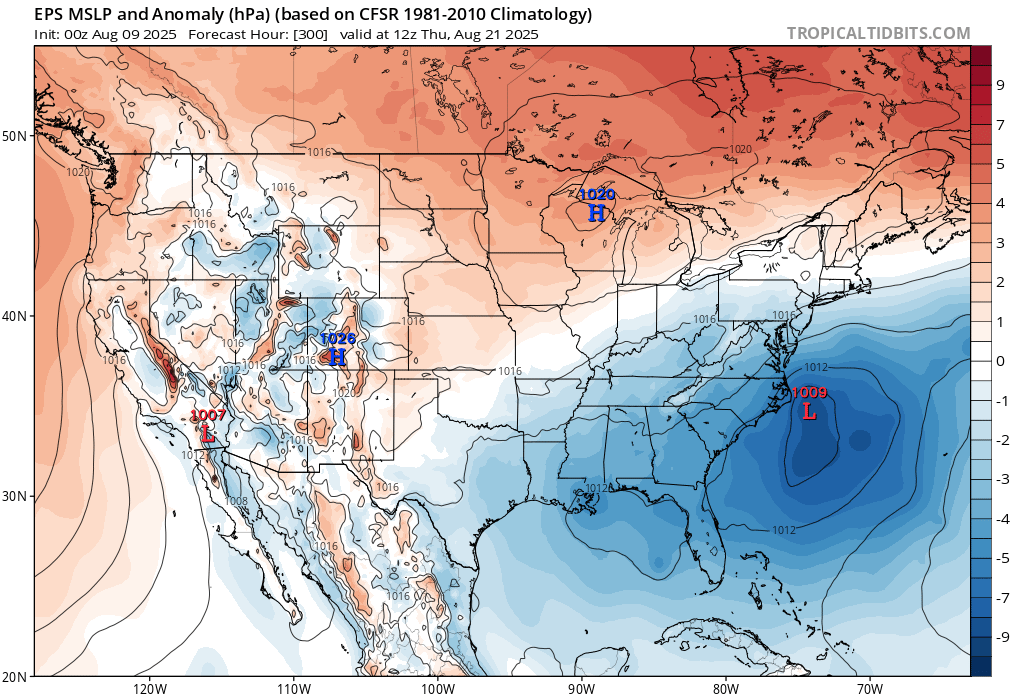
EPS be like…
-
That will leave a mark

-

Eastern Tropical Atlantic Wave - 0/40
Scott747 replied to BarryStantonGBP's topic in Tropical Headquarters
Stop with the goofy ass titles. -
I shudder at how bad the hype would be:
-

Eastern Tropical Atlantic Wave - 0/40
BarryStantonGBP replied to BarryStantonGBP's topic in Tropical Headquarters
OI LAD -
extratropical storm dexter
BarryStantonGBP replied to BarryStantonGBP's topic in Tropical Headquarters
OI DEXTER LAD THANKS FOR THE HEATWAVE LIL FELLA NOW I CAN FINALLY CRACK OPEN A STELLA https://news.sky.com/story/tropical-storm-dexter-to-bring-potential-heatwave-next-week-13408278 TA DEX

-
Big damage on euro
-
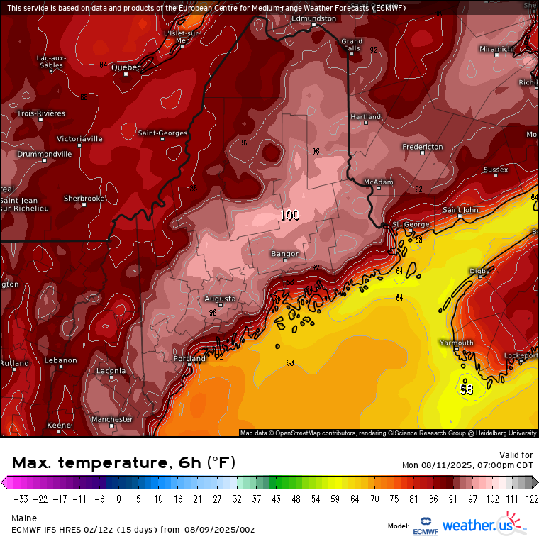
 Especially when the models have 100° record heat potential into Maine this week. That is telling you how strong the WAR is. Mid-August heatwaves along the East Coast have often been disrupted by tropical activity in the past.
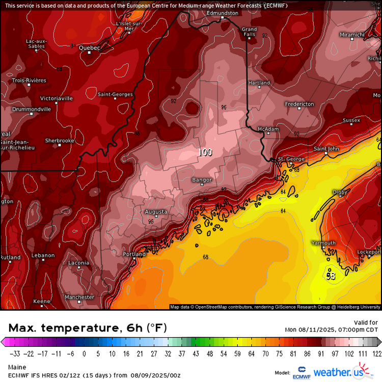

- Today
-
Eastern Tropical Atlantic Wave - 0/40
BarryStantonGBP replied to BarryStantonGBP's topic in Tropical Headquarters
2. Eastern Tropical Atlantic: A tropical wave located near the west coast of Africa is producing a large area of disorganized showers and thunderstorms. Some slow development of this system is possible next week while the system moves west-northwestward at 15 to 20 mph across the eastern and central tropical Atlantic. * Formation chance through 48 hours...low...near 0 percent. * Formation chance through 7 days...low...30 percent. -
 Very concerning. Obviously way too far out to figure track out but given tendency for ridges to overperform it's a bit scary.
 -
It’s coming
-
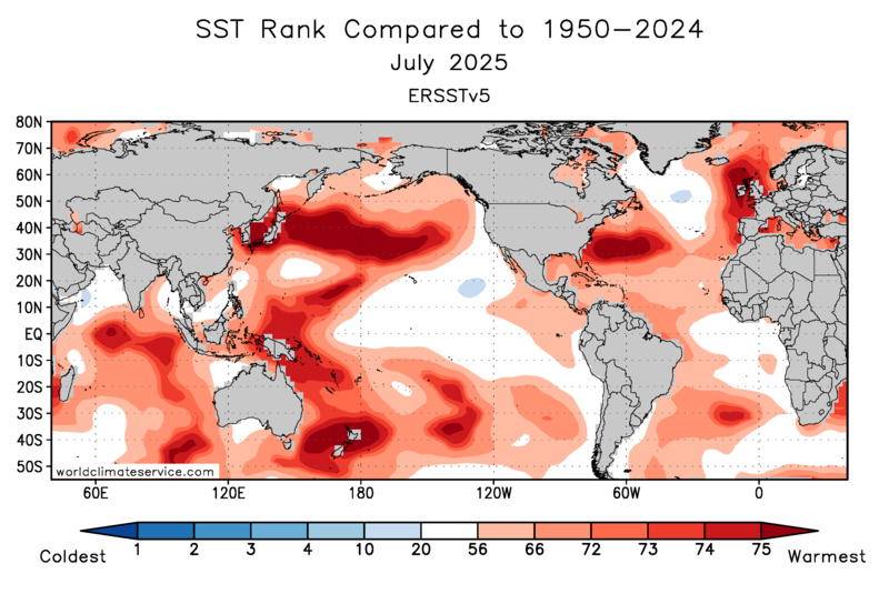
All the models have hurricane potential off the SE Coast in around 10 days. Unusually favorable pattern to get something strong into that region. Warmest SSTs on record for this time of year and strong high pressure to the north.

-
58