All Activity
- Past hour
-

2025-2026 ENSO
40/70 Benchmark replied to 40/70 Benchmark's topic in Weather Forecasting and Discussion
I understand your argument...I just don't fully agree with it. I think part of this unfavorable storm track is regression to the mean after getting high off of a decade that dealt 40" winters out like crack. And I am convinced that even if NYC gets 50" in another winter, you won't change your mind. It will be "they are done now in this new and even warmer, climate"....keep kicking the can. -
Chris when was JFK's latest 80+ temperature, was it last year or in 2022 or in 1950?
-
wow so both the 95 in October 2019 and the 82 last November are monthly records, Chris? And were the 96 at EWR and 95 at LGA also monthly records in October 2019?
-
2020-2021 didn't have below average heights per se, but there were certainly some lower heights and colder air knifing into the country.
-
From NWS just now, exerpt, Brattleboro: Tuesday Night Showers likely, mainly after 2am. Mostly cloudy, with a low around 57. Chance of precipitation is 70%. Wednesday Showers likely. Mostly cloudy, with a high near 68. Chance of precipitation is 60%. Wednesday Night A chance of showers. Partly cloudy, with a low around 40. Chance of precipitation is 30%. Discussion: While the dry and unseasonably warm trend continues into Monday, our attention then turns to a shortwave trough and associated sfc cold front progressing form southern Canada into the Northeast. Guidance has trended earlier with the start time of the rain ahead of the sfc boundary with most ensembles now suggesting rain spreads into areas north and west of Albany Tuesday evening before rain advances further east overnight. There remains uncertainty regarding the intensity of the shortwave trough tracking through Canada which will provide the necessary forcing for ascent to enhance the precipitation shield along the incoming boundary. Ensemble clusters suggest two types of scenarios. If the trough become neutrally to even slightly negatively tilted by Tuesday night, the CVA ahead of it should be strong enough to support a widespread soaking rain with 24-hr rainfall probabilities through 00 UTC Wed for near or above 0.50" ranging 50-70%. On the other hand, should the trough be weaker, limited CVA along the boundary will keep rainfall amounts lower with 24-hr rainfall probabilities for at or greater than 0.50" near or under 30%.
-
NYC needs two things in order to have a 50” snowfall season. One is an average winter temperature close to 32°or colder. The other is a cold storm track out near the benchmark. NYC has been nowhere near achieving this combination since the winters shifted so much warmer since 2015-2016. First, the winters shifted warmer in 2015-2016 which was followed by a storm track warming since 2018-2019. NYC highest snowfall total over the last decade has only been 40.9”. The coldest winter temperature has only been 34.8°.
-
Yeah...we did get a great pattern late February and March and established prime troughing for us
-

Occasional Thoughts on Climate Change
Typhoon Tip replied to donsutherland1's topic in Climate Change
It's a drug addiction metaphor. It feels really good ( immediate dividends on growing season...) until it is no longer sustained, and then it's is horror story journey to either a demise, or a helluva lot of hardship to recover. -
2015 was the last year of the Florida 10 year record of no hurricane landfalls. 2016 started a remarkable 8 year stretch of 16 Hurricane landfalls in the gulf coast. Feast or famine as the saying goes.
-

Spooky Season (October Disco Thread)
kdxken replied to Prismshine Productions's topic in New England
-
2017-2018 had some decent troughing....I mean, did I pull nearly 4' in March with a ridge??
-
2025-2026 ENSO
40/70 Benchmark replied to 40/70 Benchmark's topic in Weather Forecasting and Discussion
I promise...if we get beyond the next solar min and nothing has changed, then I will fully capitulate. I wish I could say the same for the other side if NYC sees 50". -
I think it is extremely difficult right now to have an idea of what influences La Nina will have. There has been a markedly big shift in the hemispheric regime during La Nina events over the past few decades. With La Nina you always at least had some degree of troughing in North America, whether that be into Canada that would extend into the northern latitudes of the U.S. or into the PAC NW...but this signal has been almost absent mins 2010-2011 and 2021-2022 basically since the 80's.
-
Who is this clown!? Of course he screws Loudon and HoCo.
-
2025-2026 ENSO
40/70 Benchmark replied to 40/70 Benchmark's topic in Weather Forecasting and Discussion
I don't agree with this, but it's no sense arguing because this topic is so politicized....no one is ever going to change the other's mind. My guess if that even if it happens, the debate will still wage on because it will get worked into the narrative some how...."Well, we are fortunate we had a mismatch, which I saw comeing when the October MJO spiked...but it won't happen again". Long story short...it's like politics. No one is ever going to change their mind or admit that they are wrong...and around, around we will go- -
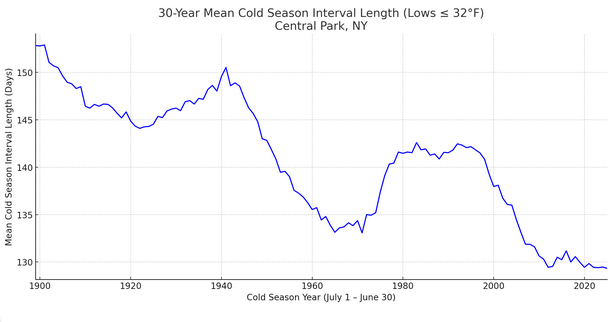
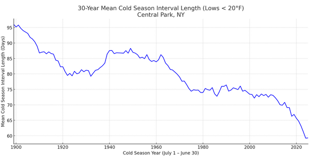
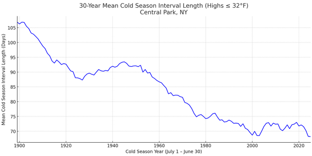
Yes, the cold season is being compressed. Lows of 32° or below: Lows < 20°: Highs of 32° or below:
-
at least 50 inches in oakland MD.
-
A moderate RONI implies a pattern that appears to be correalting to a degree comensurate with said strength...regardless of whether or not the La Nina is coupled. All I care about in a seasonal outlook. The RONI doesn't measure the how well La Nina is coupled...MEI does that.
-
Spooky Season (October Disco Thread)
Typhoon Tip replied to Prismshine Productions's topic in New England
If by minor changes we mean upslope snow occurrences over a couple ... three different flat windy CAA intervals, with an in between season's first synoptic snow possibility - verification notwithstanding - before Halloween? sure -
Quickly yo 67
-
Why do you say that? Since I am only pointing out what the current climate is capable of producing. Absent a major volcanic event, it’s statistically unlikely for NYC to see a 50” season with how much the winters and the storm tracks have warmed.
-
This type of wx is possible up my way this time of year. We shall see.
-
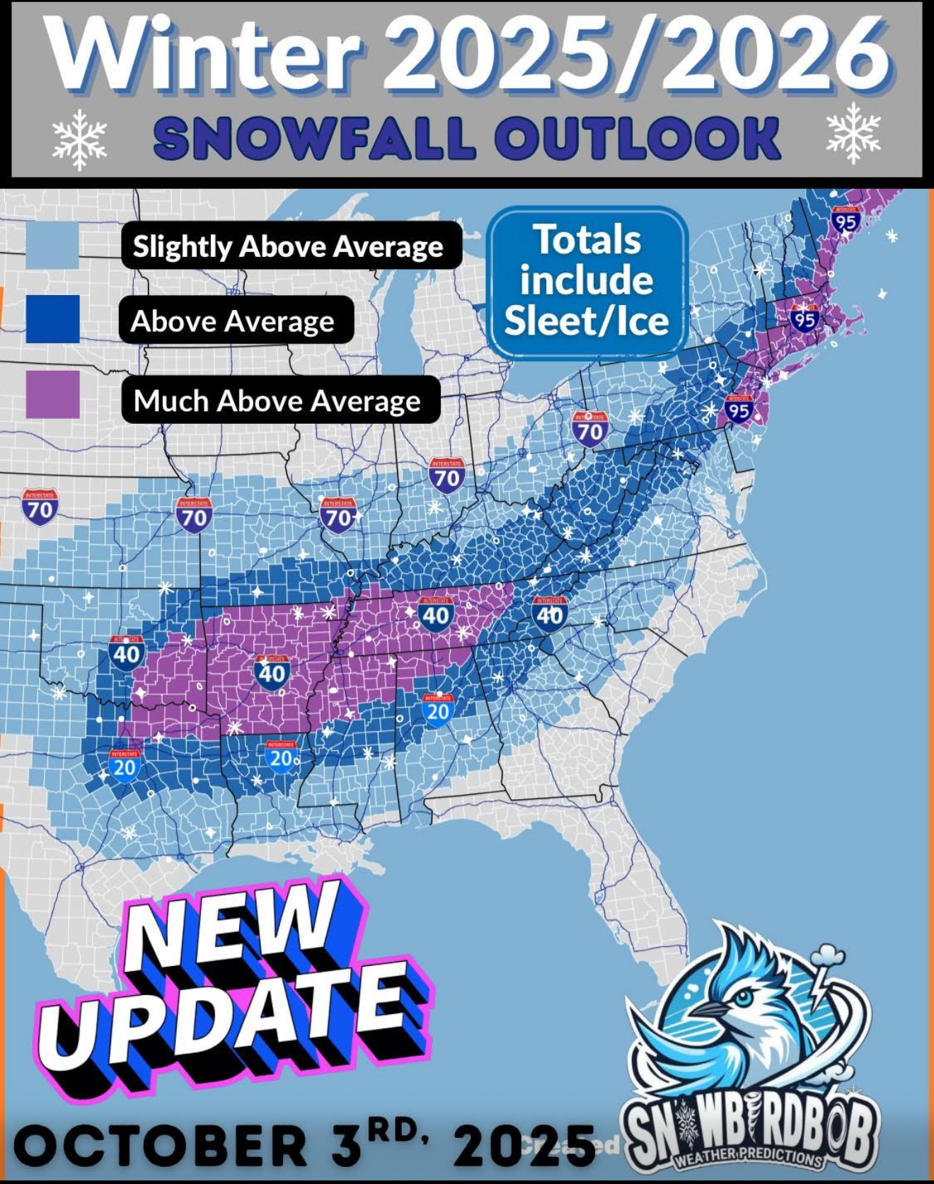
Easiest winter forecast ever? Lol
-
Some scattered shwrs/stms blossomed around my area last night. 0.20" from that. Looks like the lawn will have to be mowed one last time.
-
2019 could be tough to beat for a while but JFK set their all-time November high last year at 82°. Time Series Summary for JFK INTERNATIONAL AIRPORT, NY - Month of Nov max high temperature Click column heading to sort ascending, click again to sort descending. 1 2024 82 0 2 2022 80 0 - 1950 80 1 3 1993 77 0 - 1982 77 0 - 1975 77 0 4 1974 76 0