All Activity
- Past hour
-
From pro met. “USTropics”, here’s a very detailed post that I won’t pretend to understand fully. Any opinions? “There are a few things making the satellite presentation appear that Edouard is weakening, but don’t let these processes fool you. This is not land proximity or dry air entrainment (WV would show this). The full process we are witnessing; During the initial ‘ramp up,’ deep convection is typically asymmetric. This creates intense, localized potential vorticity (PV) anomalies. The ‘ramp down’ (where cloud tops warm and deep convection appears to collapse) is the system digesting these anomalies. The asymmetric PV is sheared out by the developing cyclonic flow and mixed into the symmetric mean vortex. Edouard is simply spending its energy aligning its low-level and mid-level circulation centers rather than fueling vertical updrafts. Central pressure is a response to the integrated column warming (hydrostatic balance) and the broadening of the wind field (gradient wind). When the initial convective bursts collapse like it did earlier, they leave behind a thick mid-to-upper level stratiform deck and a broad area of latent heat release. This residual warm core forces the mass field to continue adjusting. The central pressure drops as the wind field expands, even though the intense, localized vertical velocities (and thus cold cloud tops) have temporarily vanished. This Is why recon is still finding pressure drops. This lull is actually highly productive for the storm. As the PV concentrates in the center and the pressure drops, the inertial stability of the inner core increases dramatically. High inertial stability resists radial outflow, meaning that any subsequent latent heat release will be trapped locally near the center. In addition, we have to account for diurnal convective pulsing. Deep convection typically peaks in the early morning hours (the ‘ramp up’) and naturally wanes by mid-to-late afternoon (the ‘ramp down’). If a system is undergoing vortex alignment during the daytime/evening, the lack of convection looks like a structural failure on infrared satellite, even while reconnaissance aircraft find a falling pressure. Once the center is vertically stacked and the inner core has achieved high inertial stability, the next convective burst hits a dynamical tipping point. Because the heating is now occurring in a highly symmetric, stable environment, the energy efficiently projects onto the symmetric vortex. This triggers a much more sustainable and deep period of intensification.”
-
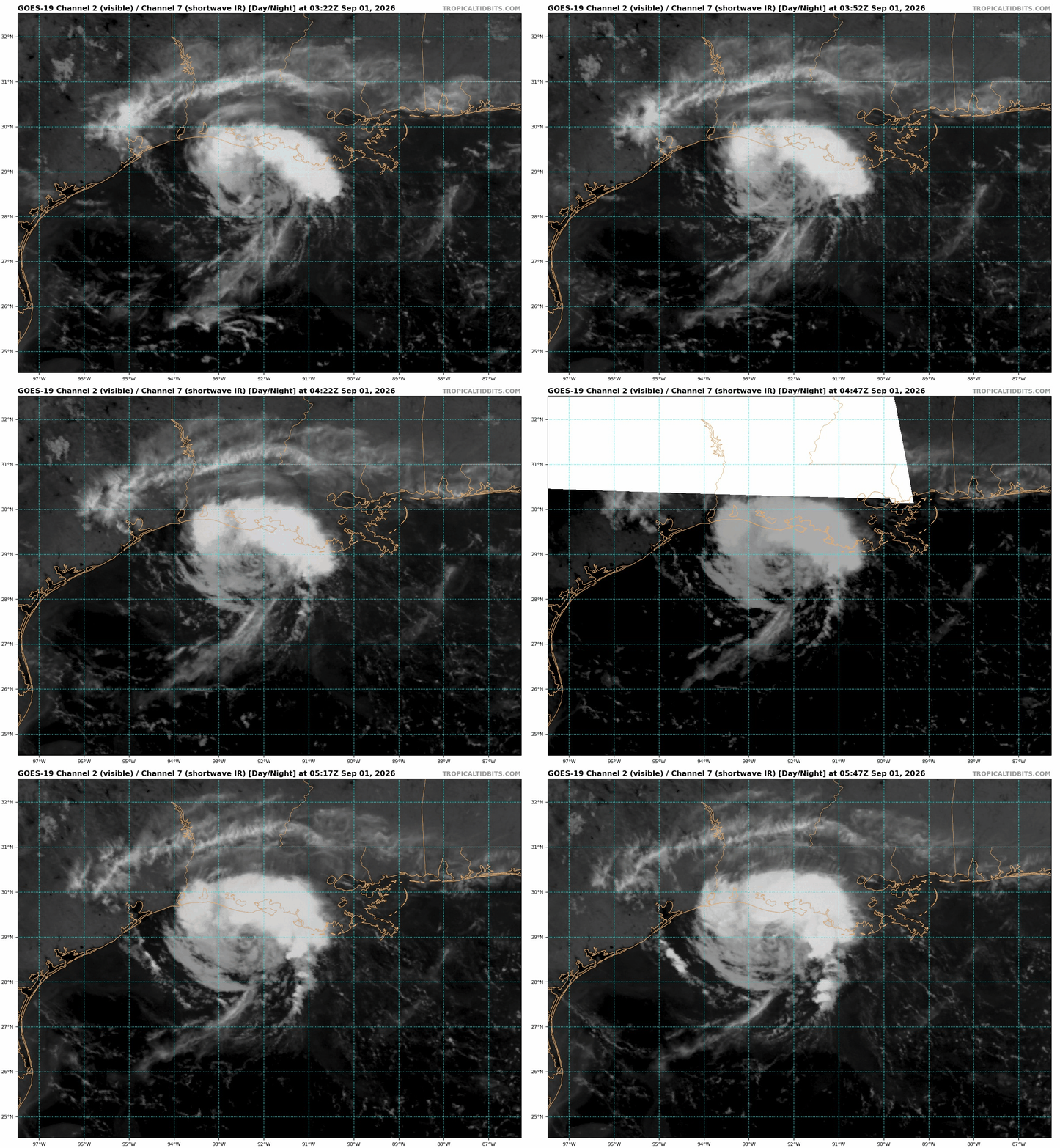
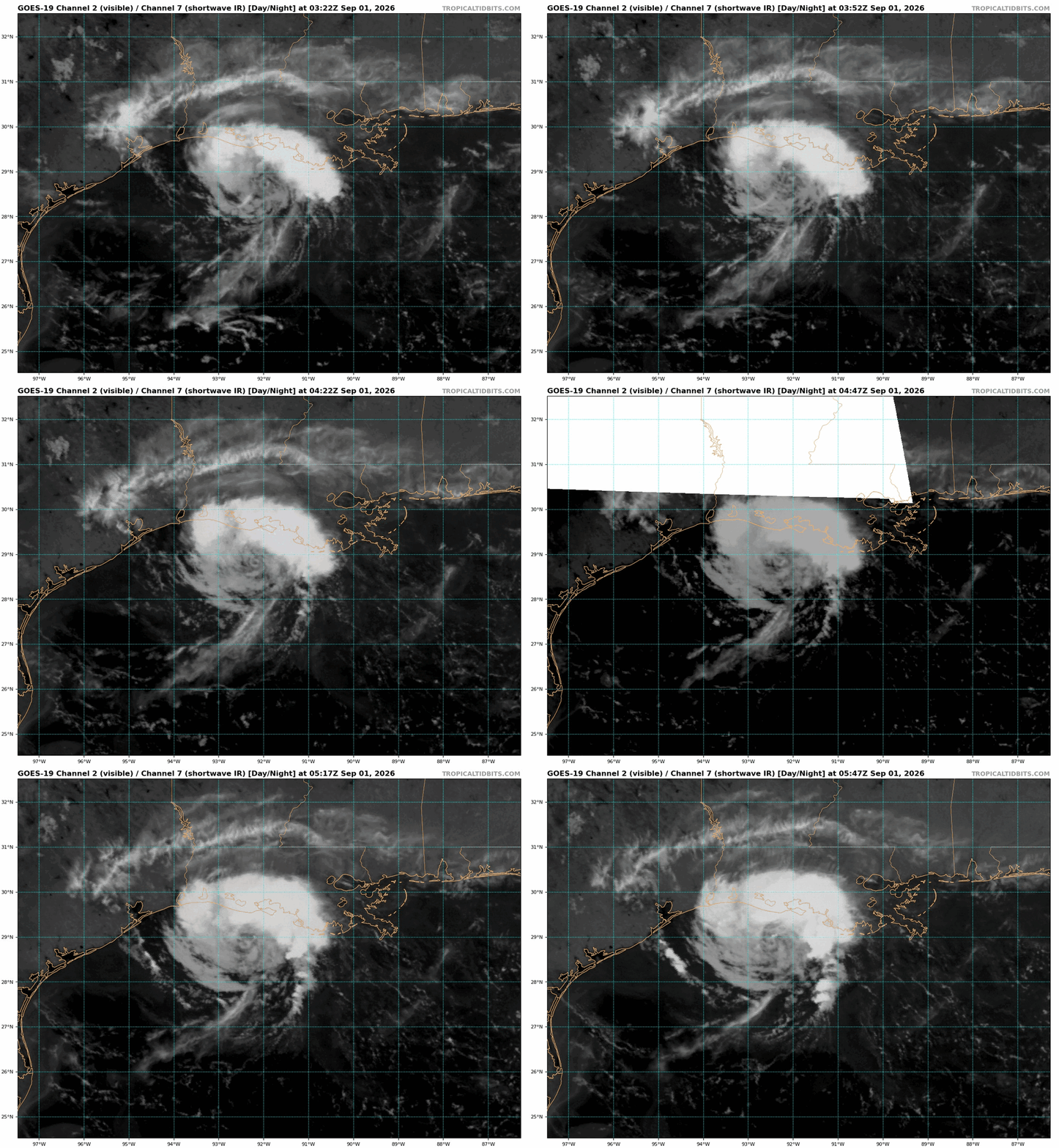
Here's something that I find very interesting I just noticed, and can't recall seeing or noticing this before. We know the shear is low overall, but look at the SWIR loop (channel can see LLCC better at night). Notice over the LLCC two tiny quick flares of convection shearing off to the NNE. So it appears there is some kind shear present, and given all the deep convection is on the N side, that makes sense there is some southerly shear present!. Also, on the SE side of the storm, look at the line of cirrus moving steadily WNW, faster than the storm is moving. Also, the convective band SE quad has it anvils shearing WNW. So this indicates some ESE shear impinging on the storm as well (different level?). For a TC of avg or large size, or one that was already strong, such shear would likely be brushed off and not a factor, but for a small, weak TC? This is what I meant about how sensitive small TCs can be to even subtle factors/changes in the environment. And all this analysis above is of value. First, as I noted I can't recall seem such localized shear over a LLCC like this when environmental is shear is low, so I add that to my TC analysts skill, and second, you can see how the finer details here can tell you a lot for nowcasting and have big implications to one's fcst thought process!
-
 NWS Fairbanks on X: "Through August 30th, Fairbanks has experienced its coldest year to date in 54 years (since 1972), with an avg temp of 28.7°F ranking as the 11th coldest year to date. The warmest temp recorded this year was 81°F, the 2nd coldest maximum ever. Here's a look at the numbers. #akwx" / X I don't know how to embed, but the lowest Summer maxes in Fairbanks since 1980.. 3 of them roll forward to a good +EPO signal for the following Winter
 - Today
-
 https://quickph.shop/# reputable overseas online pharmacies
 -
https://quickph.shop/# reputable overseas online pharmacies
-
Good point. We’ll see if there’s a convective burst over the center in the coming hours. Like your post earlier stated, models are going to struggle forecasting intensity here. The environment as it stands tells us a lot, and we’ll see how close to the ceiling Edouard gets.
-
https://quickph.shop/# reputable overseas online pharmacies
-
That was a quick .35 edit: Make that .65
-
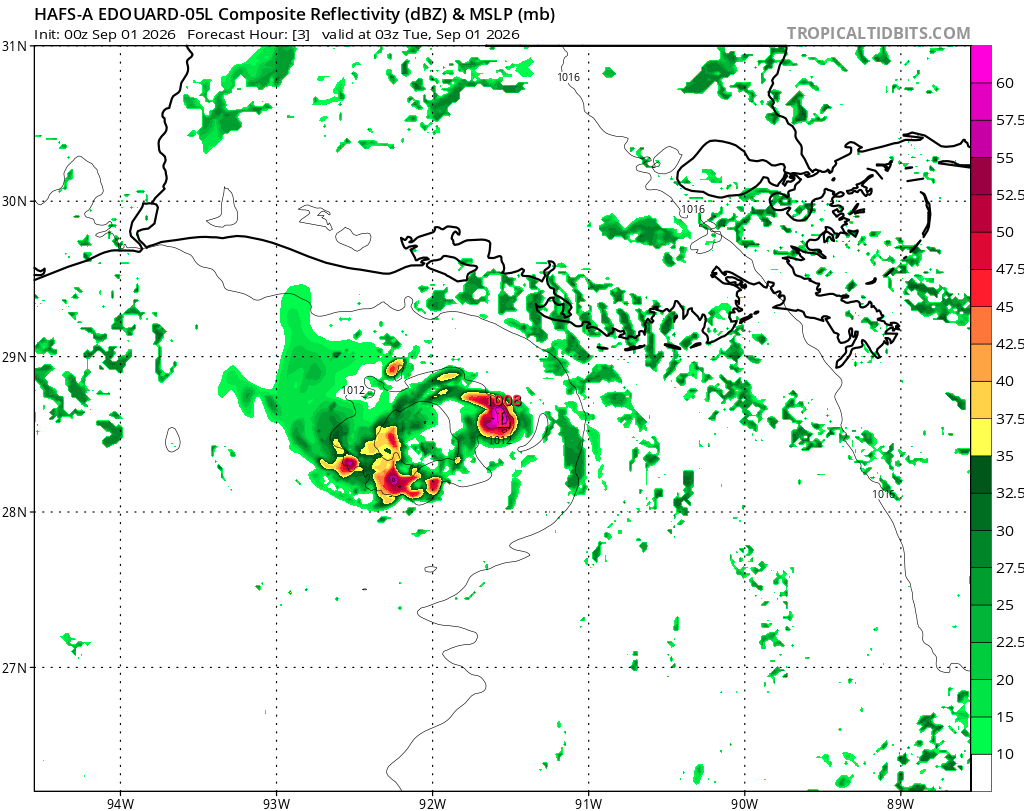
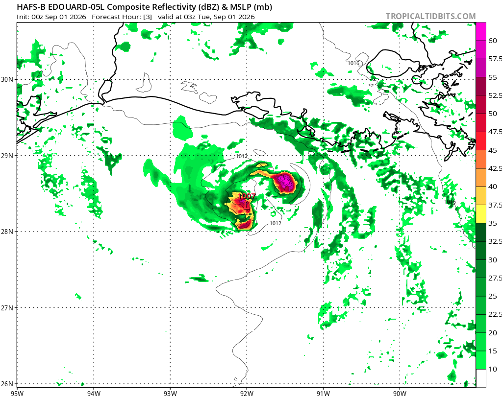
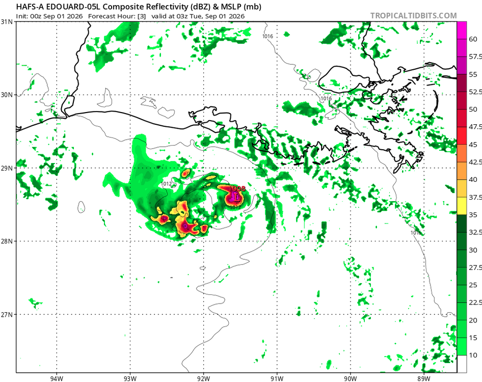
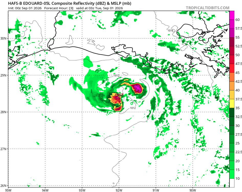
It appears HAFS-A/B are in error b/c they both show strong convection right over the LLCC 03 and 06z, and this is resulting in feedback. I attached the fcst hr 3 valid 03z from the HAFS-A/B. That did not verify. Also, the strong N side convective band on sat we see now is not handled well. So their later fcst hours are questionable. These small differences in initialization when dealing w/ convection and structure can result in large errors. The HAFS is known to do a great job, but tiny TCs like that are not common, and I don't have a feel for their performance in such cases. It is tempting to be impressed by the hires models now, but they can give very realistic and precise-looking output that can be precisely wrong. No change in in winds or pressure last recon pass 0444z. So I and hesitant on RI still. Sometimes, I go to myself, "prove it to me!" that X can happen, and sometimes I am proven wrong! But I try to not let "just b/c the models say so" or "NHC says this" influence independent judgement and gut in forecasting. Doing very short-term "what has happened up until now and trends" and what is current -- that I put more weight towards. Edouard's case is almost like what convection will do during a big svr day fcst, and you know how fickle and uncertain that can be!
-
Yep. And we’ll see it happening on radar. Homebrew systems are interesting more often than not imo. Here’s another one.
-
In marginal or so-so conditions, a system can get organized quickly when it comes to a LLCC and the TD/weak TS stage, but true RI going 25-30 kt in 18 hr is a significantly more of a challenge or unsure. I'd more concerned about RI here if the environment was marginal due to mdt shear and surrounding environment was sufficiently most as that can lead to RI in some cases. See here: https://journals.ametsoc.org/view/journals/mwre/146/11/mwr-d-18-0020.1.xml
-
If it starts deepening into daybreak then it may be onto something...
-
I swear I just peeked at it and was going to post. Very interesting. HAFS-B is more muted but gets it close to hurricane strength.
-
HAFS-A goes NAM into landfall. 14 mb drop the last 3 hrs....
-
 DCA: +2.5 NYC: +1.0 BOS: +1.0 ORD: +4.0 ATL: +3.0 IAH: +2.5 DEN: +1.5 PHX: +2.0 SEA: +1.0
 -
https://x.com/tropicaltidbits/status/2094626737204466099?s=46&t=0ZvB_AF2VfA6c0SDxf53yA .
-
Gains in organization got us a TS and some slight increase in inflow and wind, but Edouard needs deeper cells to wrap the nascent core. A moist environment was sampled, but some pesky pockets of stable mid-level air mass may be inhibiting deeper growth. The forecast discussion anticipates convection in the preceding hours to landfall, which could quickly spin up such a tiny vortex. Otherwise, Edouard will have maxed out its potential here. I wouldn't say the system has outperformed yet. I think we suspected the system to get named. With the forecast calling for additional strengthening now, however, I dare say it will underperform if convection doesn't take off prior to landfall. Which I find amusing now, given where we were 24 hours ago.
-
Yes, you can get mid-level eyes appear even in the TD stage. In this case, since there is no deep convection over the center, it is lower-level feature w/ shallow convection around it that makes it look like an eye. Look at the platform obs to the SW. NE winds? Talk about a small circulation! The small TC for rapid intensity changes is tricky. A small TC is more sensitive to dry air intrusions or shear than a larger one, but at the same time, having a small RMW promotes RI easier. Mesoscale factors in the inner core come into play, and are very tough to fcst. Recall HU Oscar a few years ago? That had one of the smallest RMW for a Atlantic HU on record and models had no clue!
-
The tar spots are just ugly. I feel like a lot of trees last year were not able to be brilliant orange, red, or yellow last fall, because there was so much black coloring on each leaf. I believe the red maple (sugar maple?) small trees in my neighborhood have almost none of this problem.
-
small feature that looks like an eye, but of course a true eye should come with a hurricane
-
mexican pharmacy near me: the purple pharmacy mexico - mexican farmacia
-
canadian pharmacy store: my canadian pharmacy review or best canadian online pharmacy reviews
-
Yea, pretty generous for a super nino. I'd be estatic if that occurred.
-
Yes and the newest run continues with the AN precip anomalies up and down the east coast.
-
https://www.youtube.com/watch?v=2i4xnjcMme0