All Activity
- Past hour
-

Central PA Winter 25/26 Discussion and Obs
canderson replied to MAG5035's topic in Upstate New York/Pennsylvania
Windy again. 35 mph winds. -
You’re quite the story teller! No cap. I noticed the EPS fading the SE ridge this morning as well. GEFS did the same thing.
-
Average that out and we're looking pretty good!! But seriously, yeah, there's a lot going on with how this will all evolve. I mean hell, just look at the mood the past week or so in this place! One day everyone's all high about how we actually have a couple of potential events, joking about "what Christmas torch?", and the next when that's not being modeled anymore everyone is all gloom and doom, saying we're toast until at least mid-January.
-

2025-2026 ENSO
donsutherland1 replied to 40/70 Benchmark's topic in Weather Forecasting and Discussion
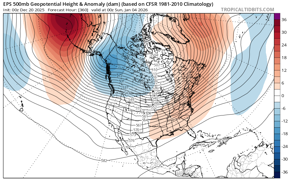
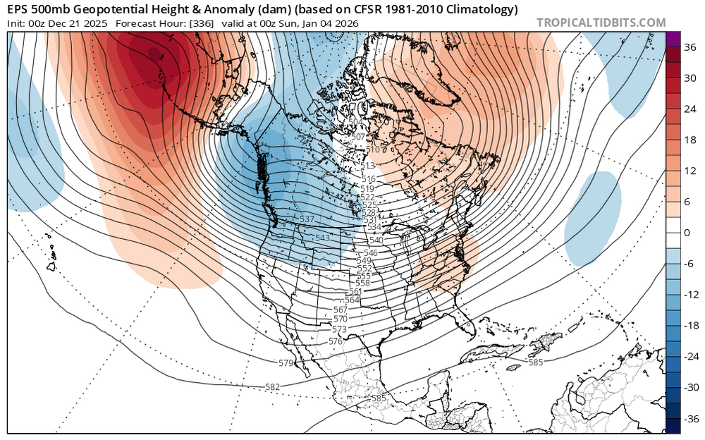
As is often the case during La Niña, winter arrived abruptly. It came on fast, cold, and at times snowy, especially across the Upper Midwest, the Great Lakes, and the Northeast. But the PNA turned increasingly and persistently negative. As its negative state grew stronger, it began to consume winter. Voices quickly rose to declare winter finished before it had truly begun. Some had even pronounced it stillborn from the outset. As Hanukkah arrived and Christmas drew near, fatalism spread like the unwelcome Influenza virus. The earlier December snows faded into memory. What remained were only fragments of seemed to be a winter that nearly was. Others, however, saw something different. They treated the shift not as an ending, but as an invitation. They saw the pause as an opportunity to reflect on moments that failed to fully arrive yet still left their mark. They recognized how seasons, like ideas or paths, often shape us not through completion, but through incompleteness. They held onto their dreams of snow, their faith in winter intact even as it was tested and surrounded by a growing chorus of voices whose belief had long since shattered. Then, on the heels of the winter solstice, the 12/21/2025 0z EPS arrived. 12/20 0z run: 12/21 0z run: Although it was one cycle of an Ensemble at a distant timeframe, it bore a message. It did not guarantee that an epic winter period lay ahead. However, with its smaller Southeast ridge, it whispered that perhaps the worst fears expressed by some might never come to pass. The journey continues.
-

White Christmas Miracle? December 23-24th
Kitz Craver replied to Baroclinic Zone's topic in New England
0z Euro and 6z GFS were both quite paltry for SNE. Like 1” maybe? Gonna need a trend reversal for 12z -

Central PA Winter 25/26 Discussion and Obs
Blizzard of 93 replied to MAG5035's topic in Upstate New York/Pennsylvania
Certainly a few things to resolve out towards NY Eve… The 0z Euro says congrats Atlanta, while the 0z GFS says congrats PA. The extent & impact of the blocking will continue to throw models fits for the at least a few more days.
-

White Christmas Miracle? December 23-24th
Sey-Mour Snow replied to Baroclinic Zone's topic in New England
Please do -

White Christmas Miracle? December 23-24th
WxWatcher007 replied to Baroclinic Zone's topic in New England
Let’s hope the Euro makes Boxing Day easy… -
Certainly a few things to resolve out towards NY Eve… The 0z Euro says congrats Atlanta, while the 0z GFS says congrats PA. The extent & impact of the blocking will continue to throw models fits for the at least a few more days.
-
White Christmas Miracle? December 23-24th
Sey-Mour Snow replied to Baroclinic Zone's topic in New England
Ya i was just thinking the last 60 hours.. That one was easy.. -

White Christmas Miracle? December 23-24th
WinterWolf replied to Baroclinic Zone's topic in New England
That thing waffled to up to the day before though on modeling…then it kind of juiced up some the last 24 hrs. -
With DC having recorded its first measurable snowfall(s) in december since 2017? I have a hard time being too disappointed by how this winter has started out.
-
White Christmas Miracle? December 23-24th
Sey-Mour Snow replied to Baroclinic Zone's topic in New England
Lol ya that too! I was thinking last Sunday storm -
December 2025 regional war/obs/disco thread
WinterWolf replied to Torch Tiger's topic in New England
True. -
White Christmas Miracle? December 23-24th
WinterWolf replied to Baroclinic Zone's topic in New England
Yes, just said that a bit ago…waffling up to the day before it seems. -

White Christmas Miracle? December 23-24th
Damage In Tolland replied to Baroclinic Zone's topic in New England
That’s really the only unknown . Models are in agreement overall . Unless one was using the gfs -
White Christmas Miracle? December 23-24th
WxWatcher007 replied to Baroclinic Zone's topic in New England
The cutter? Slam dunk on a 6 ft rim. -
December 2025 regional war/obs/disco thread
Damage In Tolland replied to Torch Tiger's topic in New England
When I’m thinking wind. -

White Christmas Miracle? December 23-24th
Baroclinic Zone replied to Baroclinic Zone's topic in New England
No need to overthink honestly. Only variable left is if any inverted trough comes more into play and where that ends up impacting. -
Ahhh! The infamous bowling ball with transient HP setup. Big dog potential or 40 degree rain with exact same LP track. That’s a go big or go home type setup. With nothing else foreseeable and one of the worst overall patterns in years establishing, I’m here for it…
-
White Christmas Miracle? December 23-24th
Damage In Tolland replied to Baroclinic Zone's topic in New England
This looks like it has for days . 1-5” SE to NW.. most in hills especially Berks . Nothing has really changed -
December 2025 regional war/obs/disco thread
WxWatcher007 replied to Torch Tiger's topic in New England
I know we’re all beaten down by the last few years and not getting as much snow as we’d like during the frigid pattern, but this relaxation is exactly the time where a shortwave could produce a solid overrunning event. With the trends we’ve seen I almost think we have to produce otherwise we might be in trouble heading into January. -
December 2025 regional war/obs/disco thread
WinterWolf replied to Torch Tiger's topic in New England
When aren’t you thinking ice …. -
Central PA Winter 25/26 Discussion and Obs
Blizzard of 93 replied to MAG5035's topic in Upstate New York/Pennsylvania
LONG TERM /MONDAY NIGHT THROUGH SATURDAY/... Overrunning precip on Monday night and Tuesday will be mainly snow overnight, but could turn to rain in the Laurels and central mtns before morning. As that change would occur, there is a strong possibility that some ZR will occur. We will continue to mention ZR in the wx grids and show a small patch of ice accum in the central mtns late Mon night and early Tues AM. We have 3 more periods to become more confident in the forecast, but may eventually need a wint wx advy for that time frame. Since there is expected to be SN at first and temps hovering in the 30-32F range for much of the CWA late Mon night and early Tues, the changeover to RA could occur without creating dangerous ZR. The highest threat of ice accumulations appears to be around AOO and UNV before sunrise. QPF will be almost nothing on the MD border, but a widespread 0.20" in the nrn half of the CWA. Most of that would be falling when it would be SN. SLRs are very low (<10:1), and accums will be a max of 1-2" with the highest accums in Tioga & Sullivan Cos. A coating (<1") is expected for much of the area before the SN turns to RA. The precip should lift off to the NE and be over around noon Tues. Temps max out in the upper 30s NE and near 50F between AOO and HGR. Gusts will increase Tuesday evening to the teens and 20s, but drop off through the day on Wed as high pressure moves in. -
White Christmas Miracle? December 23-24th
Sey-Mour Snow replied to Baroclinic Zone's topic in New England
Yes, although last storm I feel like was the easiest forecast ever..