All Activity
- Past hour
-

26th-27th event, coming at us like a wounded duck.
Damage In Tolland replied to Go Kart Mozart's topic in New England
That’s should shift 50-75 miles NE and will be about right -
I miss the politics section even though it was a cesspool.
-
If it comes in like a wall of heavy snow then he could be right.
-
He has 6 to 10 way too far south and west
-
thats really awful for my area
-
so he is often wrong and then its wash rinse repeat from him
-
 Sometimes, the models get it right. The best forecast this year was from the Euro (and just about every other model than the GFS) locking in the March 29 warming event 4-5 days out. (The GFS showed temperatures in the 30s instead.)
 -

26th-27th event, coming at us like a wounded duck.
weatherwiz replied to Go Kart Mozart's topic in New England
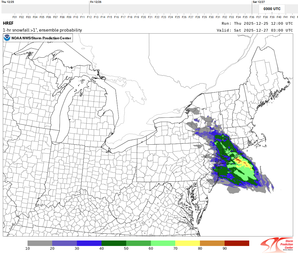
No disagreement there. The uncertainty is definitely there, particularly moving northeast of Fairfield County. Here is HREF probability for 1"+ per hour rates. Right on the border getting into Hartford and eastern half of New Haven County. I guess it may just come down to how confident the forecaster is in meeting warning criteria. -

26th-27th event, coming at us like a wounded duck.
Spanks45 replied to Go Kart Mozart's topic in New England
Lancaster County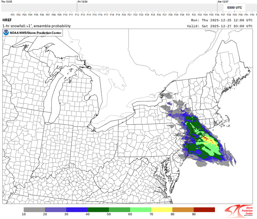
-

26th-27th event, coming at us like a wounded duck.
Ginx snewx replied to Go Kart Mozart's topic in New England
Where are you on this map. This looks like what I expect..png.660f71d52967981fe18125e1c652383d.png)
-
Yeah he has 6-10 for a large area, very bullish when even the models showing the most snow, show it in a relatively confined area. I think some get 6+ but the wide swath he has is surprising to me.
-

26th-27th event, coming at us like a wounded duck.
WinterWolf replied to Go Kart Mozart's topic in New England
Ya…was just replying to him. -
26th-27th event, coming at us like a wounded duck.
WinterWolf replied to Go Kart Mozart's topic in New England
Good points, Could be…but I don’t think they’re gonna jump yet. Too much uncertainty yet. Dry air, how far this goes NE….etc. -
26th-27th event, coming at us like a wounded duck.
Ginx snewx replied to Go Kart Mozart's topic in New England
Who cares -
26th-27th event, coming at us like a wounded duck.
weatherwiz replied to Go Kart Mozart's topic in New England
We should saturate quickly but this will be a concern along the fringes of the precipitation shield. The bigger concern with dry air IMO is how quickly does dry air filter in aloft...that is going to cut down the banding very quickly. This is one of the reasons I think its just a 3 hour or so period of very heavy snowfall and why I think max totals will be 6-8" versus something like 9-10" or 9-12" -
26th-27th event, coming at us like a wounded duck.
Ginx snewx replied to Go Kart Mozart's topic in New England
To be fair that's a typical pre storm sounding saturating from the top down. -
Steve D going 6-10 for NYC
-
26th-27th event, coming at us like a wounded duck.
WinterWolf replied to Go Kart Mozart's topic in New England
But he said go straight to a warning, where no watches are currently up. I don’t think we’ll see that. -

26th-27th event, coming at us like a wounded duck.
Go Kart Mozart replied to Go Kart Mozart's topic in New England
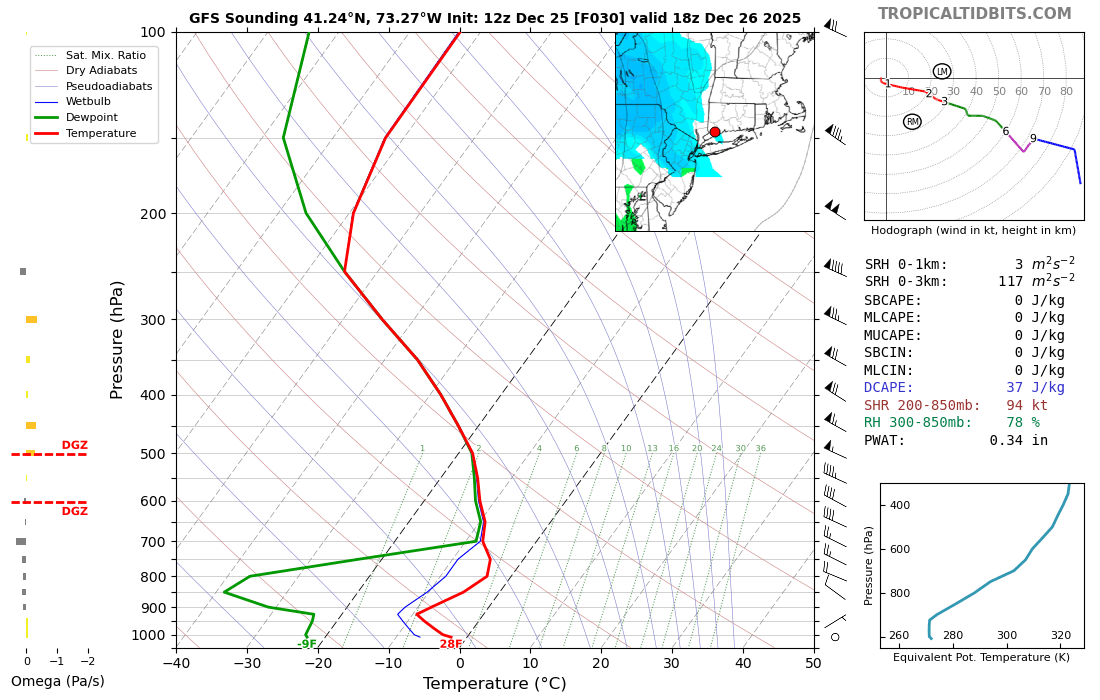
Very dry air at the outset...I mean -9f dews at the surface in BDR. The GFS radar progs show the heavy stuff moving in and out in a big hurry. I agree with those saying we need to temper expectations.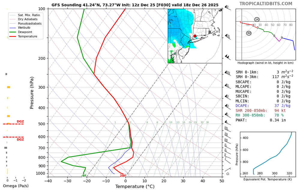
-
26th-27th event, coming at us like a wounded duck.
weatherwiz replied to Go Kart Mozart's topic in New England
I'm also factoring in holiday travel. Winter Storm Watches certainly raises awareness but you figure alot of people will probably be wanting to adjust plans today. In a normal scenario I think it would be watches then warnings tonight but holiday travel may factor into the decision making. -
There will be a sleet bomb with this one and that will be in my part of eastern PA and places west of here. The place to be with this one will be the Metro area and places to the north and east. The forcing accompanying this system looks to be the real deal for the snow lovers. I bought four bags of ice remover yesterday so I am all set. I’m figuring on 1-2” with sleet and ice on top.
-

26th-27th event, coming at us like a wounded duck.
Sey-Mour Snow replied to Go Kart Mozart's topic in New England
I def see warnings for at least half the state -
26th-27th event, coming at us like a wounded duck.
WinterWolf replied to Go Kart Mozart's topic in New England
Nah…still a full day plus left, so no need imo. -
I know we don't really use the hdrps but its been showing this solution with a really drastic drop-off
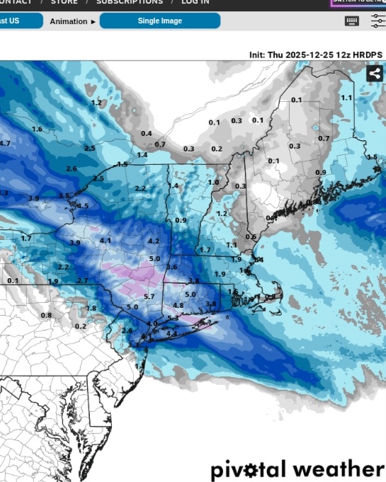
-
26th-27th event, coming at us like a wounded duck.
weatherwiz replied to Go Kart Mozart's topic in New England
Depending on how the euro swings, I wonder if we could even go straight to Winter Storm Warnings