All Activity
- Past hour
-
.thumb.jpg.6a4895b2a43f87359e4e7d04a6fa0d14.jpg)
Central PA Winter 25/26 Discussion and Obs
Yardstickgozinya replied to MAG5035's topic in Upstate New York/Pennsylvania
Even if your blower is not a brigs and stratton, it's probably going to be similar to the video above. -

The “I bring the mojo” Jan 30-Feb 1 potential winter storm
BornAgain13 replied to lilj4425's topic in Southeastern States
A lot of folks about to get NAM'd -
90-114? So 24 hours? Am I reading you wrong? .
-
Central PA Winter 25/26 Discussion and Obs
Yardstickgozinya replied to MAG5035's topic in Upstate New York/Pennsylvania
I realized the word easy is subjective, but i'm pretty confident that it is. As a landscaper, I break my pool starters several times a year, I can pull out a pulley, rewrap it, and put it back in with my eyes closed. https://youtu.be/DA5V1CdQ2hQ?si=rnWabasXm4In2ysp -

The “I bring the mojo” Jan 30-Feb 1 potential winter storm
BooneWX replied to lilj4425's topic in Southeastern States
Weathernext is stuck. Too many weenies on the server. -
The “I bring the mojo” Jan 30-Feb 1 potential winter storm
BornAgain13 replied to lilj4425's topic in Southeastern States
@wncsnowgot a pic of the weathernext? -

Possible coastal storm centered on Feb 1 2026.
Prismshine Productions replied to Typhoon Tip's topic in New England
Big difference already Sent from my SM-S166V using Tapatalk -
NAM looks to be shifting west too so far.
-
Hr60 vs 18z 66 Sent from my SM-S166V using Tapatalk
-

The “I bring the mojo” Jan 30-Feb 1 potential winter storm
Buddy1987 replied to lilj4425's topic in Southeastern States
Pretty significant changes from 18z to 0z on the NAM at 54. Much more similar to GFS. Trough starting to go toward the neutral side and heights rising in the northeast. -
The precip shield as a whole shifted west. It looks like .10 may reach middle Tennessee on there. Just estimating again. Not seen a total.
-
Which also means we are creeping west .
-
 16" d/ 1.41" w/e
 -
 Friend/ Teammate from college back in WV is now the head baseball coach there. Go Dragons!
 -
Think that would be west of the 18z GFS...not sure...just by a little
-

E PA/NJ/DE Winter 2025-26 Obs/Discussion
Ralph Wiggum replied to LVblizzard's topic in Philadelphia Region
Google's WeatherNext 2.0 model, which powers current Search and Pixel weather results, indicates a high probability of a major winter storm for Philadelphia this weekend, January 31–February 1, 2026. Forecast Highlights * Timing: Snow is expected to begin late Saturday night, peaking Sunday morning. * Accumulation: Estimates range from 8 to 12 inches, with some scenarios suggesting up to 18 inches if the storm holds its northern track. * Conditions: High-intensity snowfall (1–2 inches per hour) is likely Sunday morning, potentially transitioning to a wintry mix of sleet and freezing rain by Sunday afternoon. * Impact: Expect dangerous travel conditions and bitter cold following the storm, with wind chills dropping near or below zero. -

The Jan 31 Potential: Stormtracker Failure or 'Tracker Trouncing
Nomz replied to stormtracker's topic in Mid Atlantic
Feels like its favoring the AIFS solution. edit: take that back it looks more GFS-like -
Well 20/1 I’d say that’s a pretty good lick. .
-
Ratio that would be amazing
-
The Jan 31 Potential: Stormtracker Failure or 'Tracker Trouncing
Buddy1987 replied to stormtracker's topic in Mid Atlantic
Wow.. 54 hrs big time tilt going on.. this is trending toward gfs. You can see heights rising pretty drastically from 18z in the northeast. -
Possible coastal storm centered on Feb 1 2026.
Ginx snewx replied to Typhoon Tip's topic in New England
I would take an occluded death band or 2. Apparently that's what happened in Feb 1999 -

The Jan 31 Potential: Stormtracker Failure or 'Tracker Trouncing
bncho replied to stormtracker's topic in Mid Atlantic
Yeah, that's member #1.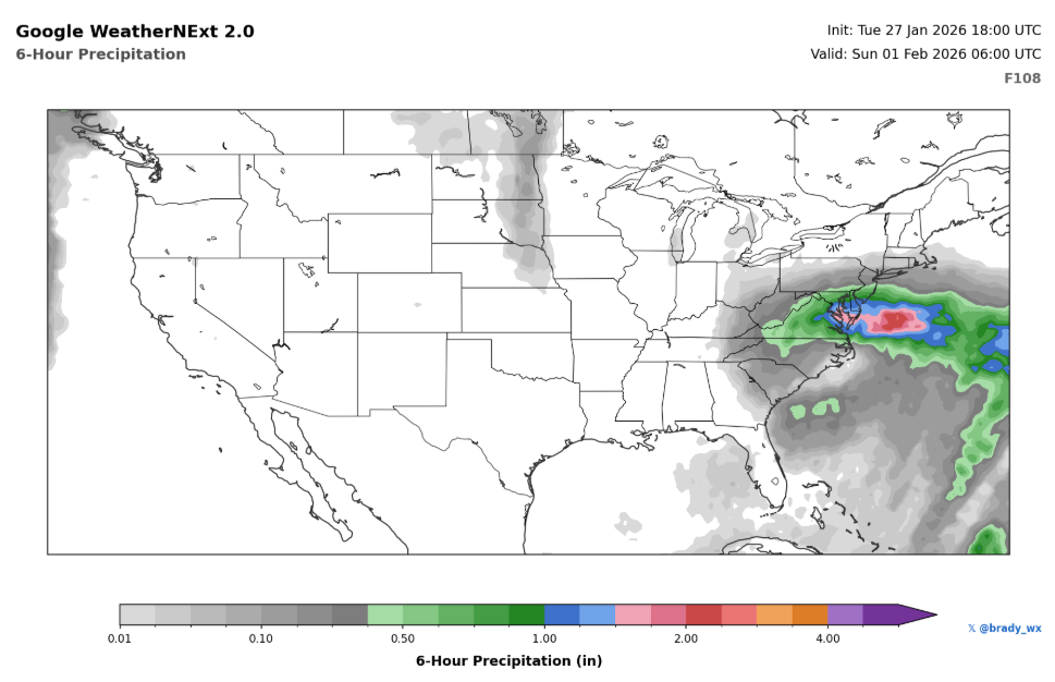
-
Looks like we are going to see around .30 to .6 qpf just estimating, on there from 90-114. Basically western Plateau and east.
-
How far is too far away? .
-

January 2026 Short/Medium Range Thread
Holston_River_Rambler replied to John1122's topic in Tennessee Valley
And by “decent” I don’t mean anything too crazy. But by no means a whiff.


