All Activity
- Past hour
-

2025-2026 ENSO
40/70 Benchmark replied to 40/70 Benchmark's topic in Weather Forecasting and Discussion
I don't think 2020-2021 was below normal there. 2021-2022 may not have been, either. -
2025-2026 ENSO
40/70 Benchmark replied to 40/70 Benchmark's topic in Weather Forecasting and Discussion
They have been for the past several years, and the WPO averaged negative without a NE warm pool to offset in 2021-2022. Anyway, I'm not arguing it's going to make it negative...just prevent it from being extremely positive. -
When was the last time snowmass was wrong and predicted a below normal winter for the tri-state which ended up busting? If your bias is in this direction than nowadays you're hardly ever wrong.
-
-
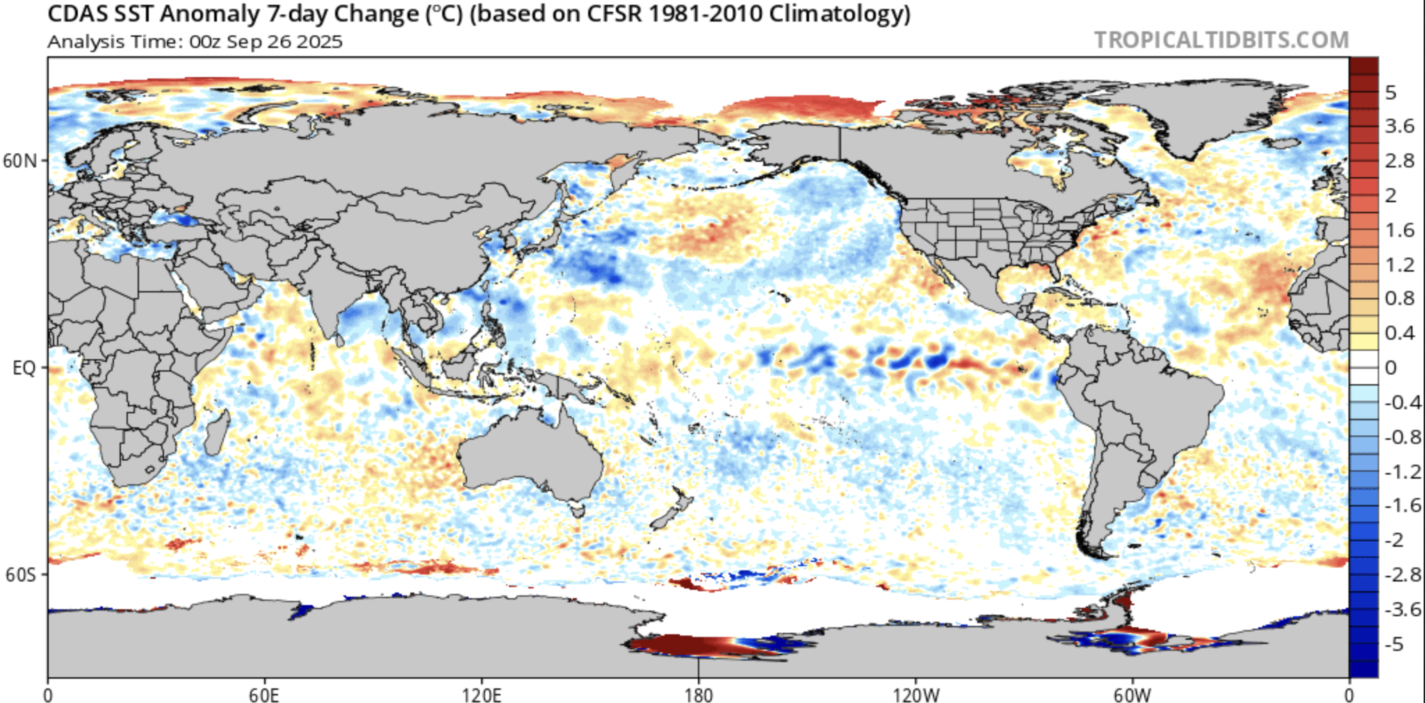
Offsetting the WPAC warm pool may be a very tall task. The above normal anomalies out that way are still off the charts
-
2025-2026 ENSO
40/70 Benchmark replied to 40/70 Benchmark's topic in Weather Forecasting and Discussion
Seasonals have it persisting. Remnant of what triple dip? It wasn't there during those three consecutive La Nina events earlier this decade. -
2025-2026 ENSO
40/70 Benchmark replied to 40/70 Benchmark's topic in Weather Forecasting and Discussion
I would feel compelled to go through those seasons and check the QBO/solar states. Its going to be difficult to sustained a storngly +AO early on with a strongly easterly QBO near solar max. 1974 and 1979 appear to be decent QBO matches- -
Rather warm to our North and West in the longrange Canada also very warm.
.thumb.png.52d9df277a34753f90944723423861e1.png)
-
Euro range to the start of October so it’s about Imelda mostly. If you look at the euro runs it’s been getting walked back further and further since yesterday morning. This is coupled with major forecasters and prominent users advertising a wet pattern for this upcoming week that, with these walk backs, is now in jeopardy. Normally I don’t harp on rain as hardly as snow but it’s fall in a budding Niña, there’s a real possibility that after this there’s nothing for quite some time. Given our luck we could make a run at last year’s rainless record again this year since September seems to be a repeat of last year.
-
 https://www.tropicaltidbits.com/recon/ https://tropicalatlantic.com/recon/recon.cgi There are other sites out there but I use these when recon is in the air. Expect consistent upper air and low level recon now.
 -
Some wonky solutions overnight and this morning. This is from the 6z gfs. This would cause a lot of flooding in the area. A lot of people would have PTSD over this... Sent from my SM-G998U using Tapatalk

-

September 2025 OBS-Discussion centered NYC subforum
STORMANLI replied to wdrag's topic in New York City Metro
0.75" Should have lowered my expectations. -
Nascent CBs concentrating on the eyewall, warm spot becoming more pronounced on IR. The eye is about to pop out
-

Invest 94L—80% 2 day and 90% seven day odds of development
NVAwx replied to WxWatcher007's topic in Tropical Headquarters
Can you link to the site of the data as it comes in? -
How much are we expecting the NE pac to cool over the next few months? My seasonal/subseasonal prof is saying the NE warm pool is a remnant of the triple dip and wont last much longer

-
6z euro still with a solid rain shield for tomorrow.
-
I think we need to specify you’re talking about Imelda, not tomorrow’s rain. And the details about Imelda have never in the faintest way approached “locked in” where anything is being walked back.
-
All eyes understandably on future Ismerelda, but nice to see a fall chill after. Lows in the mid 40s on the GFS next Friday/Saturday
-
It would not shock me to see an uncoupled (disconnected) SPV this winter where the SPV is weak but there’s a +AO at the surface, as Commoditywx showed in that tweet above. That looks like a very strong tendency of previous years with the -IOD and the Copernicus is showing it for November and December
-
Typically has a cold bias though so the consistency in warm/dry anomalies it's been progging for early season over the past couple days may be worth noting
-
Low level recon is in there for the first time this morning. Not seeing anything closed right now.
-
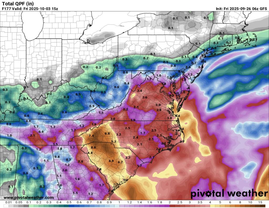
 Still more rainfall after this across NC
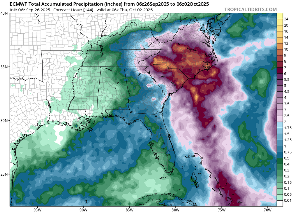
-
2025-2026 ENSO
40/70 Benchmark replied to 40/70 Benchmark's topic in Weather Forecasting and Discussion
This data set illustrates my point about how crucial the WPO will be. All of these seasons except for 1998, which sucked, had a -WPO. Having a favorable WPO leaves much more margin for error, so hopefully the western warm pool is offset enough by the NE PAC warming so that it isn't so extreme this season. A strongly positive WPO leaves virtually no margin for error around the rest of the hemisphere, so if anything else is significantly unfavorable, then most of us are cooked and upside is near normal. -
We’ll be lucky if we get half an inch and even that is starting to look overly optimistic. Walk backs beget further walk backs.
-

Occasional Thoughts on Climate Change
donsutherland1 replied to donsutherland1's topic in Climate Change
And the fact check on the political report aimed at reversing the EPA's endangerment finding. https://interactive.carbonbrief.org/doe-factcheck/images/Carbonbrief-DOE-factcheck.pdf


.png.9b0c0c891337518521376dae6edf6573.png)


.thumb.jpeg.406ecda2eec9e267302c22b9f128fe3c.jpeg)