All Activity
- Past hour
-
 Records: Highs: EWR: 99 (1944) NYC: 95 (2015) LGA: 94 (1944) JFK: 94 (1978) Lows: EWR: 57 (1945) NYC: 56 (1979) LGA: 58 (1979) JFK: 56 (1979) Historical: 1777 - The Battle of Bennington, delayed a day by rain, was fought. The rain delayed British reinforcements, and allowed the Vermont Militia to arrive in time, enabling the Americans to win a victory by defeating two enemy forces, one at a time. (David Ludlum) 1909 - A dry spell began in San Bernardino County of southern California that lasted until the 6th of May in 1912, a stretch of 994 days! Another dry spell, lasting 767 days, then began in October of 1912. (The Weather Channel) 1916 - Altapass, NC, was deluged with 22.22 inches of rain in 24 hours to establish a state record. (The Weather Channel) 1946: St. Louis, MO set its 24 hour rainfall record with a deluge of 8.78 inches on this date through the 16th. (Ref. AccWeather Weather History) 1969: During the early evening, an Air Force Reconnaissance plane investigating Hurricane Camille in the Gulf of Mexico found an unbelievably low central pressure of 905 millibars or 26.72 inches of mercury. This information allowed forecasters to warn residents along the coast that Camille would cause damage of unprecedented proportions. (Ref. AccWeather Weather History) 1974: De Pere, WI -- Lightning struck and killed a youth as he was driving a tractor on a family farm three miles west of De Pere. (Ref. Lightning-The Underrated Killer.pdf) 1978: One foot of snow fell at Yellowstone National Park in northwestern Wyoming. (Ref. AccWeather Weather History) 1980: DCA, first minimum temperature below 70 °F since July 14th a record consecutive number of hot nights. (Ref. Washington Weather Records - KDCA) 1980: Massive flooding was reported in Texas along the Cueces and Frio Rivers. Heavy rainfall from Hurricane Allen pushed rivers to levels to as much as 10 feet above flood stage. (Ref. AccWeather Weather History) 1981: On this date through the 19th, the center of Tropical Storm Dennis moved slowly through the Florida Straits and onto the lower southwest coast the next morning. Dennis then moved northeastward through southern Florida, emerging into the Atlantic between Cape Canaveral and Daytona Beach early on the 18th, taking nearly three days to cross the state. Highest winds occurred mostly in squalls well east of the center. The highest wind gusts reported with Dennis were 55 to 60 mph along the lower southeast coast on the 17th. Two tornadoes were reported in Plantation Key and Haulover Beach as Dennis moved through the Keys and Florida Bay, but no injuries or significant damage resulted. 10 to 20 inches of rain fell south and east of Lake Okeechobee, with amounts of 5 to 10 inches reported along the southeast and east-central coast. West Kendall measured 20.37 inches and amounts of 19 to 20 inches were common through the Homestead/Florida City area. (Ref. Wilson Wx. History) 1986: Thunderstorms containing devastating winds ripped across sections of eastern South Dakota. Winds gusting to 100 mph uprooted trees and damaged buildings across northern Hanson County. Several farms had all of their barns, silos, garages, and small buildings wiped out from the extreme winds. A powerful thunderstorm rolled across extreme northeast Nebraska and northwest Iowa. Winds were estimated at 70 mph across portions of Dixon and Dakota Counties uprooting numerous trees and damaging homes and power lines. Across the Missouri River in Woodbury County, Sioux City received 60 mph winds causing some power outages and scattered damage across town. (Ref. Wilson Wx. History) 1987 - Afternoon and evening thunderstorms developing along a cold front produced severe weather from Oklahoma to Wisconsin and Lower Michigan. Thunderstorms in central Illinois produced wind gusts to 80 mph at Springfield which toppled two large beer tents at the state fair injuring 58 persons. Thunderstorms also drenched Chicago IL with 2.90 inches of rain, making August 1987 their wettest month of record. (The National Weather Summary) (Storm Data) 1988 - Thunderstorms developing along a slow moving cold front produced severe weather from North Dakota to Lower Michigan during the day. Nine tornadoes were sighted in North Dakota, and thunderstorms also produced hail three inches in diameter at Lakota ND, and wind gusts to 83 mph at Marais MI. Thirty-seven cities in the northeastern U.S. reported record high temperatures for the date, including Rockford IL with a reading of 104 degrees. (The National Weather Summary) (Storm Data) 1989 - Late afternoon and evening thunderstorms in the Central High Plains Region produced golf ball size hail at La Junta CO, Intercanyon CO, and Custer SD. Afternoon thunderstorms over South Texas drenched Brownsville with 2.60 inches of rain. Fair skies allowed viewing of the late evening full lunar eclipse from the Great Lakes Region to the Northern and Central Plains Region, and across much of the western third of the country. (The National Weather Summary) (Storm Data) 1992 - One of the most destructive United States hurricanes of record started modestly as a tropical wave that emerged from the west coast of Africa on August 14. The wave spawned a tropical depression on August 16, which became Tropical Storm Andrew the next day.
 -

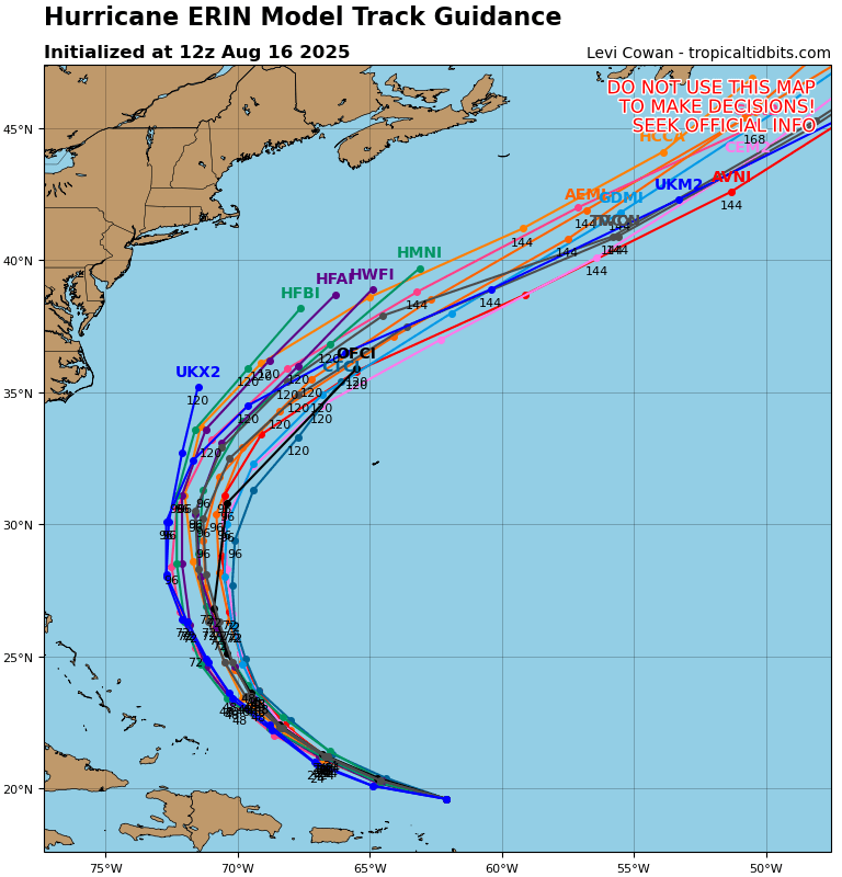
Hurricane Erin - 145 mph - 935mb - WNW @ 20
NorthHillsWx replied to BarryStantonGBP's topic in Tropical Headquarters
160kt SFMR with 145 kt FL wind. We might have ourselves a 5 -
It’s still pulling pretty far south.. it will definitely curve but this has bigger implications for PR Antilles today with heavier rain and wind , then possibly SE Bahamas and Turks will get in on sustained Tropical Storm conditions for longer now. Also the cruise lines around the Bahamas holding out hope better reroute now don’t want to be on the open waters around the Bahamas Sunday through Tuesday.
-

Hurricane Erin - 145 mph - 935mb - WNW @ 20
hawkeye_wx replied to BarryStantonGBP's topic in Tropical Headquarters
Now 925 mb (both extrap and dropsonde) -
Edit 70*
-
Insane. Another trend of RI…almost have to expect with with any storm now.
-
 Forum…thread…whatever Russ, whatever. Had some more clouds above mby this morning than expected but is localized up here, sun breaking out now, a disgusting 75/72 here.
 -

Hurricane Erin - 145 mph - 935mb - WNW @ 20
Windspeed replied to BarryStantonGBP's topic in Tropical Headquarters
We're very fortunate this CV hurricane developed at an initial higher lattitude as it passed through MDR. As luck would have it, Erin's track will avoid direct impacts on the Antilles, though we need to watch for training bands in the southern circulation causing potential flooding concerns in Puerto Rico and the DR/Haiti as it passes by to the north. Otherwise, there still remains some uncertainty as far as downstream impacts on far eastern Canada. I think Erin will pass far enough west now to avoid direct impacts on Bermuda. Not that they can't handle indirect impacts. Obviously, ocean swells and beach erosion for the US eastern seaboard from Florida to Maine will be an issue. Erin should eventually become a very large hurricane to produce large swells. But I think we are getting off quite lucky otherwise here. Erin is now an ACE machine to pump up stats prior to heading into peak season. -
With nothing to draw this to the coast and now with the RI…this will probably start to recurve even more quickly
-
79 / 69 some clouds. Partly cloudy mid/upper 80s, maybe with enough sun the hottest areas get to 90 inland. Hotter tomorrow with low - mid 90s in the hottest areas. Onshore E/ENE flow Monday cools it off with Eric riding up offshore and then hooking out to sea. Overall the week looks mainly dry and slightly cooler than normal. Wed / Thu chance of showers and looking cloudy. Warmer by the end of the week and next weekend before the cooler NE flow comes in byTue 26th for a few days. Ridge building east and expanding heat towards the close of the month, with next heat possibility. 8/16-8/17 warm/humid - Hot Sunday 8/18 - 8/21 : Cooler onshore, clouds, mainly dry Erin offshore surfers delight 8/22 - 8/25 : Warmer - perhaps one day the hottes areas could touch 90 with enhanced recent dryness 8/26 - 8/29 : Cooler 8/29 - Beyond : Warmer - hot - wetter - overall
-
75 mph gain in 15 hours
-
GR2Analyst (PR site) shows the EYE moving due W. Awesome, that's crazy how rapidly it intensified. Pressure will bottom out, how low? Slowdown and then turn to the North. CAT5 is definitely possible.
-
 why shouldn't we talk about our disappearing winters and lengthening summers?
 -
 Complaining about Central Park's bogus readings is a time honored tradition spanning 20+ years. I also hate heat and humidity so you see me comparing temps to the recent past all the time.
 -
it's funny but also sad
-

Hurricane Erin - 145 mph - 935mb - WNW @ 20
BarryStantonGBP replied to BarryStantonGBP's topic in Tropical Headquarters
SCORE SOME FOOKIN GOALS LASS! 150 MPH BAM BAM BAM Hurricane ERINAs of 12:00 UTC Aug 16, 2025: Location: 19.6°N 62.1°WMaximum Winds: 130 kt Gusts: N/AMinimum Central Pressure: 934 mbEnvironmental Pressure: N/ARadius of Circulation: N/ARadius of Maximum wind: 5 nm64 kt Wind Radii by Quadrant: -
56F for the low, great morning! I was emailed from three municipalities a lot of water restrictions on the NH Seacoast as well, not what a irrigation company wants to hear...lol
-
Yeah definitely one to watch.
-
Hurricane Erin - 145 mph - 935mb - WNW @ 20
NorthHillsWx replied to BarryStantonGBP's topic in Tropical Headquarters
The eye just moved into San Juan’s radar range and it is a perfect donut -
They aren’t shifting. Enjoy the recurve, it’s the only recurve you got.
-
Go ensembles vs an op run.
-
...well you enjoy hot temps..
-
It wasn’t very humid and was great for the beach and pool. Sunny. For August it was superb.
-
Hurricane Erin - 145 mph - 935mb - WNW @ 20
BarryStantonGBP replied to BarryStantonGBP's topic in Tropical Headquarters
Especially given today’s date storms in the Atlantic are usually pathetic like a soggy Yorkshire pudding this time of year innit -
eh if you like heat.......