All Activity
- Past hour
-

July 2025 Discussion-OBS - seasonable summer variability
Brian5671 replied to wdrag's topic in New York City Metro
I remember those days....we'd go have breakfast down there and be back by mid-day -

July 2025 Discussion-OBS - seasonable summer variability
Sundog replied to wdrag's topic in New York City Metro
By mid day my kids don't want to go the beach lol We like to go early, like 10AM -

July 2025 Discussion-OBS - seasonable summer variability
bluewave replied to wdrag's topic in New York City Metro
Looks like the best convection should stay just inland from the coast for at least the near term.
-
July 2025 Discussion-OBS - seasonable summer variability
Brian5671 replied to wdrag's topic in New York City Metro
looks like it burns off by mid-day
-
July 2025 Discussion-OBS - seasonable summer variability
Sundog replied to wdrag's topic in New York City Metro
Yea this just enough to make outdoor activities miserable but not provide any rain deficit relief. -

July 2025 Discussion-OBS - seasonable summer variability
SACRUS replied to wdrag's topic in New York City Metro
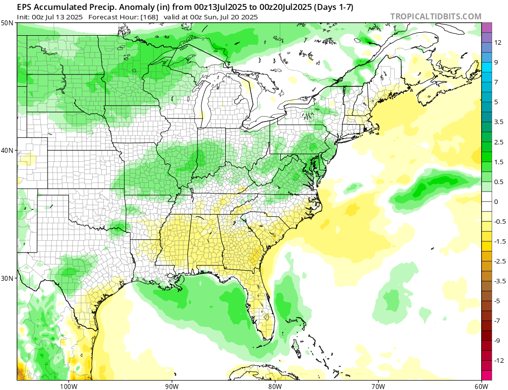
So far only 20% but a very wet / active FL the next 7 days -
July 2025 Discussion-OBS - seasonable summer variability
SACRUS replied to wdrag's topic in New York City Metro
Heaviest rains targeting just W and SW of the area the next 7 days and FL with potential tropical development in the Gulf / Pan Handle -
July 2025 Discussion-OBS - seasonable summer variability
SACRUS replied to wdrag's topic in New York City Metro
Pokes of sun with low level clouds east to west and higher clouds west to east movement -
This is A LOT of territory seeing a top 10 hottest summer, even top 5 hottest in many locations. These are only showing long term ThreadEx sites. Wow! You can definitely see West Virginia has been ground zero for the heat this season.
-
July 2025 Discussion-OBS - seasonable summer variability
SACRUS replied to wdrag's topic in New York City Metro
Records: Highs: EWR: 100 (1966) NYC: 101 (1966) LGA: 99 (1966) JFK: 94 (1992) New Brnsck: 98 (1894) Lows: EWR: 57 (1940) NYC: 54 (1888) LGA: 58 (1990) JFK: 58 (1990) New Brnsck: 52 (1923) Historical: 1895 - A tornado struck Cherry Hill in New Jersey causing fifty thousand dollars damage. It also descended into the Harlem and Woodhaven areas of New York City killing one person, and finally ended as a waterspout in Jamaica Bay. (David Ludlum) 1922: The mercury hit 134 °F at Greenland Ranch in Death Valley, CA on July 10, 1913 the hottest reading of record for the World. The old world record has been revoked. Sandstorm conditions accompanied the heat. The high the previous day was 129° following a morning low of 93 degrees. The previous world record of 136 °F at El Azizia, Libya has been revoked The World Meteorological Organization (WMO)committee concluded that "the most compelling scenario for the July 13,1922 event was that a new and inexperienced observer, not trained in the use of an unsuitable replacement instrument that could be easily misread, improperly recorded the observation and was consequently in error by about seven degrees Celsius." Death Valley is now the Earth's Highest Temperature Record 1936: Mio, Michigan : The highest temperature ever recorded in Michigan: 112 °F. Dells, Wisconsin : The highest temperature ever recorded in Wisconsin : 114 °F. (Ref. Lowest and Highest Temperatures for the 50 States) (Ref. Additional Temperatures Listed On This Link) 1951: Rivers across eastern Kansas crest well above flood stage, causing the most significant destruction from flooding in the Midwestern United States at that time. Five-hundred-thousand people were left homeless, and 24 people died in the disaster. Click HERE for more information from the History Channel. 1964: Clouds, rain and a cool northeast wind holds the high temperatures in the upper 50s to mid 60s across West Michigan. The high of 59° at Grand Rapids, MI was only the second time in over a hundred years of record that the temperature did not reach 60° on a July day. Early morning lows dropped in ot the lower and middle 30’s across parts of the northern Plains. (Ref. Wilson Wx. History) 1975 - Dover, DE, was deluged with 8.50 inches of rain to establish a 24 hour record for the state. (The Weather Channel) 1977 - Lightning struck a key electrical transmission line in Westchester County of southeastern New York State plunging New York City into darkness. (David Ludlum) 1980 - Afternoon highs of 108 degrees at Memphis, TN, 108 degrees at Macon, GA, and 105 degrees at Atlanta, GA, established all-time records for those three cities. The high of 110 degrees at Newington, GA, was just two degrees shy of the state record. (The Weather Channel) 1982: Lightning struck a woman in Chesterfield County, VA . She was sitting on a metal swing set in her back yard, and though she could hear thunder, she did not go indoors. She heard a loud noise and felt pain. Lightning struck the swing set and traveled through her body to the ground. Her shoes were blown off her feet and she received burns on her back and legs. (Ref. Lightning - Virginia Weather History) 1987 - Unseasonably cool weather prevailed across the Midwest. Ten cities reported record low temperatures for the date, including Casper, WY, with a reading of 39 degrees. By way of contrast, record heat was reported in the eastern U.S., with highs of 93 degrees at Burlington, VT, and 101 degrees around Miami, FL. (The National Weather Summary) 1988 - There were just three reports of severe weather across the country, and just one record high temperature reported. Thunderstorms brought much needed rains to the Tennessee Valley area, producing nine inches at Senatobia, MS. (The National Weather Summary) 1989 - A thunderstorm at Albany, GA, produced 1.40 inches of rain in forty minutes, along with wind gusts to 82 mph. Afternoon highs of 98 degrees at Corpus Christi, TX, 110 degrees at Tucson, AZ, and 114 degrees at Phoenix, AZ, equalled records for the date. Greenwood, MS, reported 55.65 inches of precipitation for the year, twice the amount normally received by mid July. (Storm Data) (The National Weather Summary) 1993: Heavy rains of 3 to 5 inches in an hour caused flooding of streets and roads at Dodge City, KS. Standing water of one and a half to two feet was reported in southwestern Dodge City. In south central Kansas, heavy rains in Kiowa County caused widespread flooding and as much as 8 inches of rain was reported in portions of the county. The Rattlesnake Creek was out of its banks throughout the county and was reported to be as wide as five miles near the Edwards county line. Railroad tracks were washed out south of Kiowa County Lake. The water subsided around 5 AM the next day. Major flooding on the Mississippi River produced a record river crest at Quincy, IL of 32.3 feet; eclipsing the old record of 28.9 feet set in April 1973. At mid-month, only 5 of 28 bridges that cross the river into Illinois were open. (Ref. Wilson Wx. History) 1995: Many daily record high temperatures and three all time record highs were recorded as the deadly July 1995 heat wave continued unabated from the Midwest to the Atlantic coast. All time highs set included: Genoa, WI: 109°, Milwaukee, WI: 108°, La Crosse, WI: tied at 108°, Chicago, IL: 106°, Necedah, WI: 104°, Trempealeau, WI: 103°, Decorah, IA: 102° and Guttenberg, IA: 102°. Heat indices soared to well over 120° in many areas and close to 130° at Chicago, IL & Cedar Rapids, IA as dew point temperatures were in the upper 70’s to low 80’s. 553 people died in Chicago alone from the heat. (Ref. Wilson Wx. History) 1996: Annandale Weather Center had 2.11 inches rain in 24 hours from Hurricane Bertha. (Ref. Annandale Weather Records - KRIC)(Ref. More information about Hurricane Bertha) 2002: Winds up to 80 mph swept through Kingman, AZ damaged or destroyed dozens of homes. Four people were also injured from flying debris. In Chloride, winds were estimated at 100 mph which caused significant damage. (Ref. Wilson Wx. History) 2004: A violent tornado quickly developed across Woodford County, Illinois during the mid afternoon. This tornado was at F4 intensity as it demolished a manufacturing plant four miles west of Roanoke. Although 140 people were inside at the time, all escaped injury by reaching storm shelters a few minutes before the tornado's arrival. Steel beams and metal siding from the plant were found approximately three quarters of a mile east in a farm field. (Ref. Wilson Wx. History) 2008: A streak of 24 consecutive days (ending August 5th) of 90° or higher began on this date at Denver, CO. This shattered their previous record of 18 days established in 1901 and 1974. (Ref. Wilson Wx. History) -
July 2025 Discussion-OBS - seasonable summer variability
Brian5671 replied to wdrag's topic in New York City Metro
Very dry here-lawns going brown quickly. Monday looks inland for showers as well. -
July 2025 Discussion-OBS - seasonable summer variability
bluewave replied to wdrag's topic in New York City Metro
Nuisance drizzle but no relief from the recent dry pattern and having to water the garden to keep it going. -
July 2025 Discussion-OBS - seasonable summer variability
SACRUS replied to wdrag's topic in New York City Metro
79 / 71 and partly cloudy. Warm and humid today mid- upper 80s with the inland sunnier /hot spots seeking 90. More of the same Monday into Tue with more storms and slow moving drenchers for isolated places. Hotter by Tue/Wed with the seasons next heatwave for many, especially inland. Pending on clouds forecasted 850 MB temps push 20c later Wed/Thu and with enough sun could get some stronger heat (95+) into the hot spots. Overall hotter/humid and wetter into the beyond. Seas breeze / onshore for periods but some day or couplets of days where west flow pushes out and on through as ridge centers more inland. 7/13 - 7/14 : Warm / humid rain focus on Mon- Tue 7/15 - 7/18 : Hotter - humid - Strong heat possible with enough sun Wed/Thu 7/19 - beyond : Hot / Humid overall wetter -
I just graduated from the VT Program, and am considering returning for masters in an adjacent topic. Your ideas seem to be the profs current thinking at the moment with respect to AI. I’ve heard from numerous people that the field is shifting towards a model where meteorologists will be interacting with the public much more, instead of sitting at the forecast desk all day, at least in the public sector.
-
High of 97.1 yesterday at 5pm, but it felt worse at 10:30 when the HI was 110 and I was doing some tree pruning. I couldn't make it more than 40 minutes outside. T of rain yesterday evening.
-

July 2025 Obs/Disco ... possible historic month for heat
HoarfrostHubb replied to Typhoon Tip's topic in New England
Yeah. Thinking by 10 or so here. Yesterday the grossness continued until early afternoon. -
July 2025 Discussion-OBS - seasonable summer variability
Sundog replied to wdrag's topic in New York City Metro
Low clouds are fine. There were lots of clouds around yesterday where I am but we still got a beach day in. Today's it's raining on the shore. -
Zooming in over Baltimore and Washington. In the official Baltimore thread, 2025 currently sits in 8th place. I do question the thought process of grafting on some of these rooftop Customs House readings, rather than including them in the downtown Baltimore thread. Speaking of downtown, currently in 2nd place (since 1950). IAD is checking in at 4th place summer to date. DCA is mired in an unimpressive 11th place. In fact, according to these rankings, 8 summers had as warm or warmer start just since 2010. Richmond, Virginia currently sits in 6th place, tied with 2008.
-
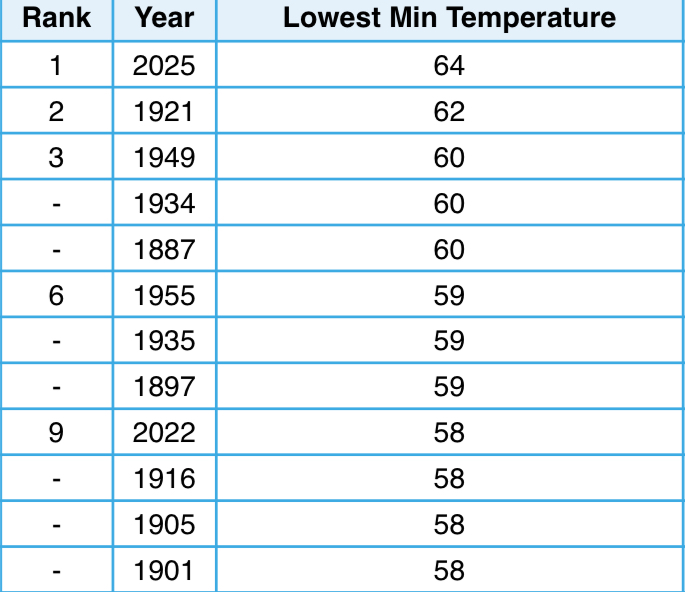
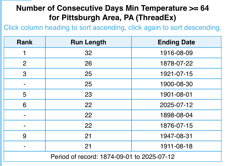
Here’s the list. The warmest in the threaded record is 62 in 1921. We also continue to climb the list of consecutive days without dropping below 64. Today will move us into 5th place on that list, and it’s already the longest streak since 1921. Looking at the extended, 2nd place is a guarantee and 1st place is very likely.
-

July 2025 Obs/Disco ... possible historic month for heat
CoastalWx replied to Typhoon Tip's topic in New England
Sun broke out early here. -
Very impressive heat across the region so far this summer. As we approach the midpoint of summer, it's clear 2025 has not disappointed for summer weather lovers. Back-to-back scorchers areawide. Might never see such extremes in two consecutive summers ever again... certainly, an impressive statistical anomaly! Some notable observations: Elkins, West Virginia has had its warmest start to summer on record, by a large margin, with 2024 dropping into 4th place. Hagerstown, Maryland has seen its 3rd warmest start to the season, behind 2010 & 2024. What a 1-2 punch with back to back scorchers in 2024 & 2025. Roanoke, Virginia has seen its 4th warmest start to the season, behind 2024, 2010 & 1925. Clarksburg, West Virginia has seen its 2nd warmest start to summer, behind only 1934's Dust Bowl aided heat. 3rd warmest at Huntington, W. Va. Easily the hottest at the current airport location. 2nd warmest at Beckley, W. Va., with 2024 in a close third.
-

July 2025 Obs/Disco ... possible historic month for heat
Torch Tiger replied to Typhoon Tip's topic in New England
clipper lol -
Not sure why this morning over other recent days but humidity feels like the Amazon
-
July 2025 Obs/Disco ... possible historic month for heat
HoarfrostHubb replied to Typhoon Tip's topic in New England
Another gross, manky start to the day. hopefully we get some earlier sun. Makes all the difference -
July 2025 Obs/Disco ... possible historic month for heat
CoastalWx replied to Typhoon Tip's topic in New England
Last full week of July looks darn warm. Quick mild down next weekend.