All Activity
- Past hour
-
Yes, and 106 readings I got in my car driving through Queens in 1993, 2010 and 2011. I agree that there are some parts of the city that are hotter than others, so if we can use some thermometers, we should be able to use them all.
-
Once the ridge relaxes around 6/27-28, heights remain elevated but it would turn/hot humid with chances for storms keeping rainfall normal - above.
-
There were 100 degree readings in NYC 2021
-
1806 - A total eclipse of the sun was viewed from southern California to Massachusetts. (David Ludlum) 1972: Agnes was first named by the National Hurricane Center on June 16, 1972: It would go on to make landfall between Panama City and Apalachicola, Florida, on the afternoon of June 19. Hurricane Agnes would later cause catastrophic flooding in the mid-Atlantic states, especially Pennsylvania. Agnes caused over 100 fatalities. Did Agnes make landfall near JFK too? wow this must have been absolutely amazing, was totality reached in NYC?
-
That 1.71 at Damascus is only about 6 miles north of me (I'm close to that 0.24)
-
It’s been a very rough stretch for the areas around the Gulf extending up into places like Asheville last year.
-
People engaged in this soc med pastime seem to impulse-down-play when they sense someone's exuberance ... LOL. Probably? this is a good thing. Maybe even instinct as a crowd physical means to normalize the group think toward sensibility. You know, stop a rash decision/recourse that takes out the whole tribe.. heh - then again, we have amongst us some sources that really need that because they are known violators of common verbal decency when it comes to porno interpretation of the modeling cinema - Be that as it may, I would be a little concerned in this case that something extraordinary may be be "cooking." Just keep that on the back "burner" as a non-zero possibility. We have in fact gained on this signal's prominence among the multi-method technique, ranging from ens/mass fields, telecons that represent those (numerically), ...operational version both subtle and gross comparisons... etc. All of them, spanning now 4 consecutive day's worth of runs. The confidence is about as maxed out on what it can be against "model climate error" for a D6-10 range. I mentioned this yesterday and it is still the case... this is a candidate for a synergistic heat bomb. One that that by nature of their emergent properties, would be difficult to see coming. Think 'rogue wave' phenomenon in a stormy sea. The wave at least needs the stormy sea within which to occur. In this case, clearly there is a hot pattern demonstrative, what happens exceeding the predictions that are linearly available for interpretation. Models and man and blend... indicate X, you get X' or X'' That said, there are some basic framework recognition that can be made in evaluated those leading circumstances. For example, in every case, ...it didn't just spontaneously erect extraordinarily hot temperatures. There is at least antecedent synoptic anomaly/history either predicted or on-gong, then the system - perhaps even related to quantum Non-Markovian effect, effecting a quasi closed system. It's a theoretic that the future state of a system is based not just on the quantum presentation, but also the quantum memory... Having nodal hot dome that's being left to fester, fed by intense insolation over multiple diurnal cycles ... When we say "high launch pad" that isn't merely figurative, that is suspiciously very alike a system's quantum memory emerging the linear observation. Anyway ... for now, what I suggested yesterday imho is still in place. One, we rely mainly on ensemble means. Two, this non-linearity of exceeding the look ... that's all something that really can't be assessed with any "degree" of certitude ( haha), but in recognizing the basic framework.. yeah. The other thing to consider is that it won't be 120 here like the Pacific Northwest. We're still going to be loaded with more atmospheric impurities and other offsets that are normal. But, setting records across back to back diurnal days or something ... We'll know if we dealing with a special case if/when
-
why will it be wet in the long range Tony? Hot means dry most of the time, any *wet* would be confined to inland areas where scattered tstorms occur but these do not reach the coast most of the time.
-
JB is actually calling for a not as active season as last year with ACE of 120-150, whose midpoint of 135 is only slightly above the ~122 avg of 1991-2020 along with only slightly above avg 7-9 H and near avg 2-3 MH: Saffir-Simpson Hurricane Wind Scale Forecast Named Storms: 15-19 Total Hurricanes: 7-9 Major Hurricanes: 2-3 ACE Index: 120-150
-
Records: Highs: EWR: 98 (1981) NYC: 96 (1994) LGA: 96 (1991) JFK: 92 (1962) Lows: EWR: 52 (1946) NYC: 52 (1927) LGA: 55 (1961) JFK: 52 (1965) Historical: 1794: A frost was reported at Mansfield, MA, repeating a previous occurrence made on May 17th. (Ref. Wilson Wx. History) 1806 - A total eclipse of the sun was viewed from southern California to Massachusetts. (David Ludlum) 1895: Heavy rain fell in portions of central Arkansas, damaging several roads and bridges. At Madding, east of Pine Bluff, 6.12 inches of rain fell in six hours. 1906: On this date through the 17th, a tropical storm moved north out of the Caribbean, through the middle Florida Keys and exited into the Atlantic near West Palm Beach, gaining hurricane strength over the Atlantic. (Ref. Wilson Wx. History) 1917 - The temperature soared to 124 degrees at Mecca climaxing the most destructive heat wave of record in California history. (David Ludlum) 1921: Yosemite Valley, CA received a trace of snow, their latest on record for this late in the season. (Ref. Wilson Wx. History) 1924: A short, but intense heat wave in Wichita Falls, TX reached its peak on this date. The maximum temperature was 111°. This followed a high of 110° on the previous day, and was followed by 108° the next two days. (Ref. Wilson Wx. History) 1944 - A tornado in Sioux City, IA, traveled an odd course. It spun in one place for about twenty minutes, made a U-turn, traveled southeast for about three miles, then traveled south, east, north, and finally east again. (The Weather Channel) 1964: A late season snowfall left a trace of snow over all of northern Maine. Guttenberg, IA set a record low for June with 40°. (Ref. Wilson Wx. History) 1965: On the 16th and 17th -Severe floods occurred in Colorado as 12 to 14 inches of rain fell on portions of the east slopes of the Rockies and the plains east of Denver. 14 inches fell in just three hours at Palmer Lake and Larkspur, CO with 12 inches at Castle Rock. A wall of water as high as 20 feet roared down both branches of Plum Creek into the South Platte River near Littleton and through Metro Denver. Flood waters spread to a width of a half mile in Denver. The citizens of Denver received reports of the flooding to the south and had a few hours to initiate evacuation procedures along the South Platte River greatly limiting the loss of life. Around midnight, the torrent crested at 25 feet above normal with the flow exceeding 40 times normal. This is the record flood on the South Platte and many of its tributaries. Many homes and businesses were destroyed. Damage totaled $230 million dollars. 8 people were killed. (Ref. Denver, CO Weather History) 1972: Agnes was first named by the National Hurricane Center on June 16, 1972: It would go on to make landfall between Panama City and Apalachicola, Florida, on the afternoon of June 19. Hurricane Agnes would later cause catastrophic flooding in the mid-Atlantic states, especially Pennsylvania. Agnes caused over 100 fatalities. 1975: New York City--Two children were killed and seven injured by a single bolt of lightning when they took refuge from rain under a tree in Central Park. 1987 - Temperatures soared above 100 degrees in the Upper Midwest, reaching 104 degrees at Lincoln, NE. Thunderstorms produced wind gusts to 96 mph at Valley City, ND, and baseball size hail near Red Oak, IA. (The National Weather Summary) (Storm Data) 1988 - After a brief respite, hot weather returned to the Northern High Plains Region. Late night thunderstorms in Montana produced wind gusts to 70 mph at Polson and north of Lake Seeley. (The National Weather Summary) (Storm Data) 1989 - Daytime thunderstorms produced severe weather from northern Florida to the Middle Atlantic Coast. The thunderstorms spawned eight tornadoes, and there were 138 reports of large hail and damaging winds. Thunderstorm winds gusting to 87 mph caused twenty million dollars damage at Columbia SC. Strong thunderstorm winds killed one person at McLeansville NC. (Storm Data) (The National Weather Summary) 1992: A devastating tornado ravaged portions of southwest Minnesota. Commonly referred to as the Chandler-Lake Wilson tornado, this tornado destroyed more than 75 homes, with another 90 houses, 10 businesses, a church, and a school damaged. In addition, the tornado caused over $50 million in property damage, resulting in more than 40 injuries and one fatality. Based on a detailed damage assessment by the National Weather Service, it is estimated this F5 tornado packed winds over 260 mph as it tore through the residential area of Chandler, Minnesota. This was the only F5 tornado to occur in the United States in 1992. 2008: Western and central New Yorkers experienced a rare widespread large and damaging hail event. For two hours, cell after cell rolled along a similar path across southern Niagara, southern Orleans, Monroe, Wayne and northern Cayuga counties many of which had hail of up to an inch-an-a-half diameter. Then more thunderstorms that formed later produced hail up to two inches in diameter, a rare event for western New York. One thunderstorm formed over Grand Island intensified as it moved southeast across the densely-populated northern and eastern suburbs of Buffalo. The golf-ball sized hail damaged thousands of automobiles as well as windows, roofs and awnings on homes. At the Amherst Middle School, the hail pierced 1200 to 1500 holes in the skylight roof. While property damage was significant, the damage to area crops was devastating. The hailstones pummeled fruits leaving divots and cracks. Vegetable plants were stripped of their leaves. Apples, peaches and pears that were not stripped from the tress and could have been sold for eating fresh will have to be sold for processing at a substantially lower cost because of being misshapen and bruised. The U.S. Department of Agriculture issued a Disaster Declaration for Erie, Genesee, Monroe, Ontario, Orleans and Wayne counties. (Ref. Wilson Wx. History) 2014: The Pilger tornado was the most intense of the family of tornadoes produced by the supercell. This tornado developed about 6 miles southwest of the town of Pilger and moved northeast, directly striking the city. Initially narrow and relatively weak, the tornado significantly intensified as it neared the Elkhorn River and moved into town. The tornado cut a path through town, destroying numerous homes and businesses. The tornado was responsible for 1 fatality in the town of Pilger and several injuries before moving northeast and weakening. During a weakening period, the tornado again intensified, producing additional violent damage 4 miles northeast of Pilger. Finally, the tornado narrowed, weakened, and turned east, wrapping around the developing Wakefield tornado before dissipating.
-
Apparently my whining about cells missing all month was noted. Had 2.76" when I went to bed last night. Then an additional 3.15" overnight for an event total of 5.91". I declare uncle.
-
It doesn't really factor in when NYC and JFK don't factor in. The 40s and 50s were quite a bit hotter. I know you like to use micronets but perhaps if we had micronets in the 90s they would have been even hotter. Hell, I'm going to start using my car thermometer lol. Back in 1993 my car thermometer registered a temperature of 106 degrees driving through Queens which was only matched in 2010 and 2011. Why don't we wire in everyone's car thermometers into the micronet that way we can cover the entire region?
-
Timing of the front looks a bit slow for us. Needs to speed up a few hours.
-

2025-2026 ENSO
40/70 Benchmark replied to 40/70 Benchmark's topic in Weather Forecasting and Discussion
Yea, ACE is more predictable.....obviously the most important factor is land impact. -
I'd like to thank the GFS for being good for like 6-12 months forcing the ECMWF to give the Euro away for free.
-
2025-2026 ENSO
40/70 Benchmark replied to 40/70 Benchmark's topic in Weather Forecasting and Discussion
No matter how cool and wet it seems, in this day and age its always going to end up one of the warmest (insert timeframe) on record. Even if the days aren't featuring warm maxes, either the night won't radiate and/or someother area of the globe will obersving record all-time warmth. -
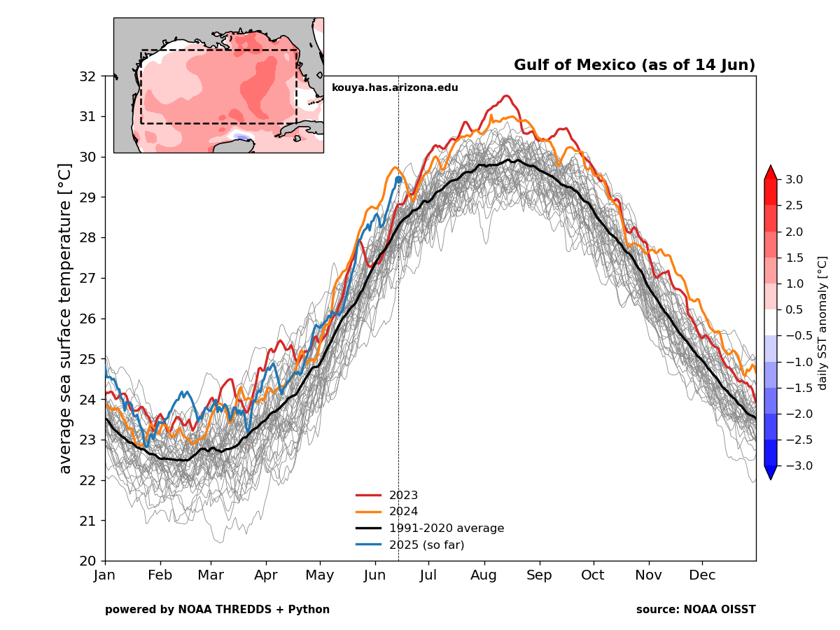
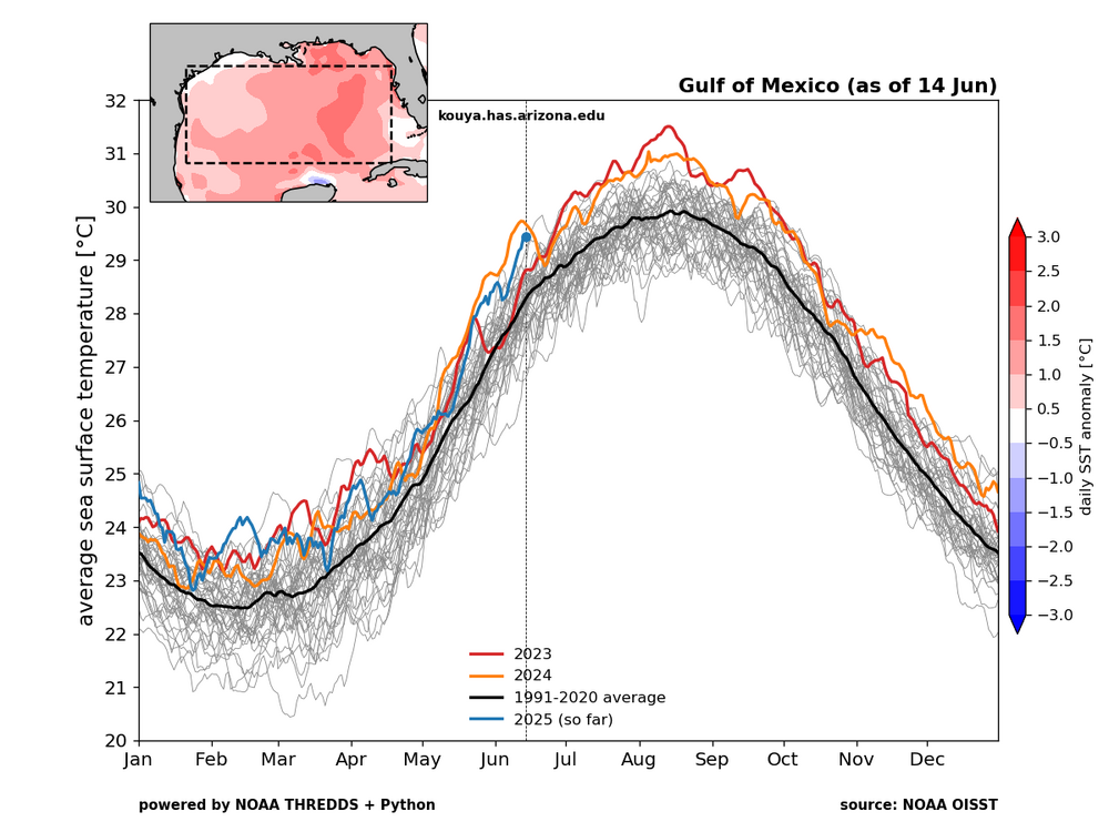
I come at it from a different point of view. ACE is only relevant if storms are making landfall. We can remember 2010 with the very high ACE and the dominant OTS storm tracks. 1992 was a very low ACE season but we had Andrew. But the most significant seasons feature high ACE and landfalls. So sometimes we get caught up in seasonal forecasts of overall ACE. But my focus is landfalling storms. That being said, we have been in a record landfalling hurricane pattern in the Gulf since 2017. The Gulf SSTs are currently the 2nd warmest on record for this time of year. So I will consider this a big season if the Gulf sees another major hurricane landfall by the end of the season no matter what the ACE finishes at.
-
2025-2026 ENSO
40/70 Benchmark replied to 40/70 Benchmark's topic in Weather Forecasting and Discussion
Oh, mercy...I don't even count him as a reputable source. -
No changes from my Sunday morning post... except to add the small potential for a nw flow severe event Sat afternoon, especially eastern parts of our area (CT/LI). That in addition to whatever happens this Thursday as currently outlooked by SPC. I looked at XMACIS and there just isn't any need from my perspective for a heat thread. What is coming is sort of normal for June, especially interior. The sudden change will take a few by surprise but little doubt in my mind we experience heat advisory (June 95-100) interior Thu afternoon, and then possible heat warning or however the NWS titles it for early next weeks MAX HI 100-105. Duration (4 day or 7day+ heat wave of 90+uncertain for KEWR) but I think heat wave likely begins Sunday afternoon. Right now WPC max HI only goes out to Monday and is more conservative.
-

2025-2026 ENSO
PhiEaglesfan712 replied to 40/70 Benchmark's topic in Weather Forecasting and Discussion
It was only average in number of named storms. If you take a deeper look, 2013 finished with a Top 10 lowest ACE season, with only 2 hurricanes, and no major ones. (Even 2014 didn't go that low in those respects.) 2013 put up some numbers that seem unfathomable in this 21st century climate, especially coming off 3 very active seasons. It's a well-below average season. -
All Cold All The Time.
-
62 / 58 day 3 and hour 58 of the latest cloud invasion. 0.89 in the bucket since Friday night. Cloud lingering much of the next 36-42 hours keeping temps more like April but there is heat (light) at the end of the proverbial dingy grey tunnel we have been in. Warmer by Wed but front is still pushing the boundary north to trigger storms but we should see some sun and spike temps into the 80s. Chance of storms Wed and Thu evening. Thursday, pending on clouds sees >16c 850MB temps and the chance of the next 90s for some and first for many. In what could be a period of 8 of 10 90 degree days (6/20 - 6/30) with heat building north and east and a strong ridge pushing heights to >588- 594 DM next week. Watch for any undercutting the ridge to create any onshore for coastal sections. Hot period with an overall higher heights warm-hot but could be featuring storms potential in the beyond. 6/16 - 6/18 : Clouds cooler - warmer wed 0.25 - 0.45 inches forecast (scattered) 6/19 - 6/20 : Warmer - hot in areas (6/19) 6/20 - 6/30 : Hotter with strong ridge into the EC - could remain with storm potentials keeping it Beyond : overall wetter and hot
-
JB is going for a high ACE Atlantic season with above average storms as he normally does. Wants an excuse to predict a -NAO winter
-
Mid 100s deep into Suffolk County is beyond just being summer. That is historic
-
The drought in AA County is definitely completely dead. It's actually pretty swampy here in the lowlands. Today looks like a nice day to take off work due to weather and go for a long hike before the heat kicks in for the next 4 months.