All Activity
- Past hour
-

2025-2026 ENSO
40/70 Benchmark replied to 40/70 Benchmark's topic in Weather Forecasting and Discussion
Yes...this fits with what I am saying about a decidedly +NAO season still having a period or two of extensive blocking...which don't have to mean a HECS necessarily, either. -
The summers began to warm faster in the Northeast starting in 2010. Since then the Northeast has experienced 12 out of 15 warmer to record warm summers. We are on track this summer to make it 13 out of 16. We haven’t had a really cool summer in the Northeast since 2009. All the 3 slightly cooler summers were due to the warmer climate normals. We would often get a cooler summer like 2009 after a series of warmer summers. The winter warming began to really accelerate with the super El Niño in 15-16. So the Northeast has experienced 9 out of the last 10 winters running warmer than average to record warm. This recent 24-25 winter would have only been considered average in earlier 30 year climate eras. We haven’t had a colder winter in the Northeast by historical averages since 14-15. The winter warming across the Northeast has been faster than the summer warming by several degrees.


-

July 2025 Discussion-OBS - seasonable summer variability
wdrag replied to wdrag's topic in New York City Metro
Agreed on premise. Too bad we have to be sarcastic and use CP as a cooling center. Powers that be have created the situation and for the diehards (point specific accuracy), not acceptable. -

July 2025 Discussion-OBS - seasonable summer variability
Brian5671 replied to wdrag's topic in New York City Metro
still raining here but back edge pushing through... -

July 2025 Obs/Disco ... possible historic month for heat
CoastalWx replied to Typhoon Tip's topic in New England
Greta and Stein holding us, caressing us while whispering odd socially inept things. -
2025-2026 ENSO
40/70 Benchmark replied to 40/70 Benchmark's topic in Weather Forecasting and Discussion
Yes, but things also appear to be linging up for a decent period or two of -NAO/-AO....it doesn't have to mean a -NAO/-AO season, nor does it have to mean a wall-to-wall omnipotent PV...ins fact, it most often somewhere in between. Think eclectic, and non-binary. -
July 2025 Obs/Disco ... possible historic month for heat
CoastalWx replied to Typhoon Tip's topic in New England
Nah this stays. Will go away Friday but right back into what we dew best. -

July 2025 Obs/Disco ... possible historic month for heat
dendrite replied to Typhoon Tip's topic in New England
Yup. 68.2° here. Near 70 mins used to be rare here. Notsomuch anymore. -
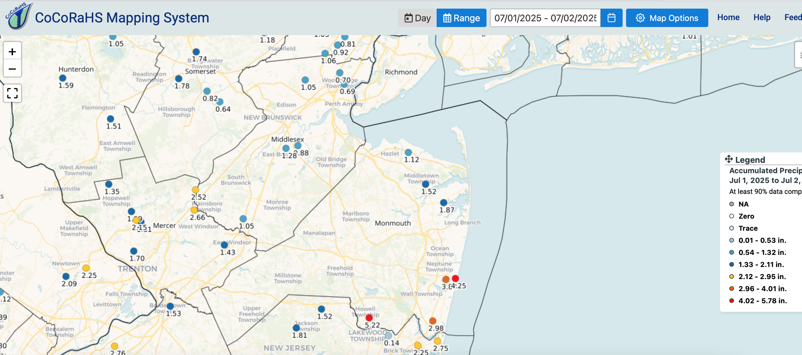
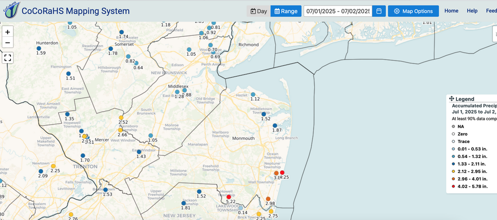
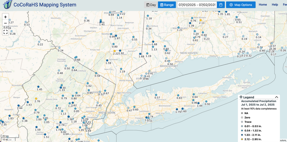
Southern edge of NYC subforum verified 5+. See attached. SVR was reserved for southern edge of our subforum - NJ. Two day totals attached as of 730AM July 2. (You can unpin whenever you want).
-
2025-2026 ENSO
40/70 Benchmark replied to 40/70 Benchmark's topic in Weather Forecasting and Discussion
Someone not heeding the advice below may have been optimistic about the 2023-2024 El Nino due to the belief that the relatively paltry MEI and RONI values were more favorable for cold and snow opportunities in the east. I know that I was. This is a perfect example of why the pose below is so crucial. One other peice of advice would be to not be afraid to admit mistakes and never stop learning. -
24 hour total as of 7am was 2.69" and it's still raining.
-
2025-2026 ENSO
40/70 Benchmark replied to 40/70 Benchmark's topic in Weather Forecasting and Discussion
This is why its important to be multidimensional and as all exhuastive and all-encompassing as possible when doing an outlook...there are no silver bullets. 2011-2012 was also a moderately strong Modoki La Nina that occured during high solar. I think if I had to offer advice to anyone doing an outlook, that sentence would be read "be eclectic in your approach as possible and be ever mindful that nothing operates in a vacuum". -

July 2025 Obs/Disco ... possible historic month for heat
SJonesWX replied to Typhoon Tip's topic in New England
ok this dewey shit can go away now. 72/70 barely got a rain shower last night, and got <0.1" yesterday morning. -
July 2025 Obs/Disco ... possible historic month for heat
CoastalWx replied to Typhoon Tip's topic in New England
No relief up north. Was about 70 for the low. -
2025-2026 ENSO
40/70 Benchmark replied to 40/70 Benchmark's topic in Weather Forecasting and Discussion
Chris articulated it best when he said that the west warm pool was competing with, and masking the El Nino to an extent....this is why the RONI and especially the MEI were relatively low. -

July 2025 Discussion-OBS - seasonable summer variability
LibertyBell replied to wdrag's topic in New York City Metro
That was the year thousands of people died in the MW, especially near Chicago. -
July 2025 Discussion-OBS - seasonable summer variability
LibertyBell replied to wdrag's topic in New York City Metro
This matches my memory of 1993 being the last year when we had good data coming out of Central Park. I noticed that wind speeds, snowfall and temperature data were lower quality after that. Do you think using ASOS itself also has something to do with the poor data or is it purely a siting issue? I also see lower quality wind reports and precip type reports coming out of there. -
2025-2026 ENSO
40/70 Benchmark replied to 40/70 Benchmark's topic in Weather Forecasting and Discussion
Yea, I'm optimistic about perhaps a-NAO month and a good period or two, but not the DM period in the mean. -
Got 1.58" yesterday in New Holland. Dumped right as I left work, fortunately I had my maintenance guy give me a lift in the golf cart out to my car
-
July 2025 Discussion-OBS - seasonable summer variability
LibertyBell replied to wdrag's topic in New York City Metro
But average temperatures <> extreme temperatures I would much rather have higher highs than have average temperatures increase. The differences between our highs and lows seems to be becoming less. -
0.01” overnight. For the event .50”. I will take it after not having any measurable rain fall since June 28th.
-
Dover radar effed up again. I was looking at it this morning when it was pouring here and it had nothing over me- it was depicting reflectivity from sometime earlier. 062 NOUS61 KAKQ 020837 FTMDOX Message Date: Jul 02 2025 08:37:56 KDOX RADAR HAS BEEN PLACED IN STANDBY MODE DUE TO DEGRADED VELOCITY DATA.
-

July 2025 Discussion-OBS - seasonable summer variability
bluewave replied to wdrag's topic in New York City Metro
It had to do with the radar range across the country with the new radars which were installed back then. https://www.weather.gov/okx/Tour_Introduction#:~:text=In 1993%2C the National Weather,as 13 River Forecast Centers. In 1993, the National Weather Service moved from its old office in New York City to this modernized facility in Upton. Placement of the office was governed, in part, by the range of the radar, about 250 miles. Nationally, there are 122 forecast offices like this one, as well as 13 River Forecast Centers. The NWS also operates 21 aviation support Center Weather Service Units and various National and Regional Support Centers. Click here to see all the offices and centers that make up the National Weather Service. -
July 2025 Discussion-OBS - seasonable summer variability
LibertyBell replied to wdrag's topic in New York City Metro
Well, instead of closing it, why didn't they actually move the equipment downtown, where people actually live and work? The 160 years of data, I don't see that as important as the climate has changed so much that what happened during the 1800s and early 1900s is now completely irrelevant. -
July 2025 Discussion-OBS - seasonable summer variability
LibertyBell replied to wdrag's topic in New York City Metro
Why did they leave to go to Upton and more to the point why were they allowed to leave? I consider parks no better than zoos, they are an artificial *natural* entity created inside a concrete jungle. If one wants to see nature one should visit a forest. I don't see the conservation movement as being helpful when it comes to parks at all, in the same way I don't see the confinement of animals in zoos as being natural either.