All Activity
- Past hour
-

July 2025 Obs/Disco ... possible historic month for heat
metagraphica replied to Typhoon Tip's topic in New England
85/61 here. Definitely feels dryer down in SE CT than yesterday. Still moist along the shore however. 79/70 at KGON. -

July 2025 Discussion-OBS - seasonable summer variability
SACRUS replied to wdrag's topic in New York City Metro
12PM round up: EWR: 90 ACY: 89 PHL: 89 ISP: 88 LGA: 88 TEB: 88 New Brnswck: 88 JFK: 87 BLM: 87 NYC: 86 TTN: 85 -

July 2025 Obs/Disco ... possible historic month for heat
dendrite replied to Typhoon Tip's topic in New England
63.6° -RA -

July 2025 Obs/Disco ... possible historic month for heat
weatherwiz replied to Typhoon Tip's topic in New England
We may actually get screwed down here. Dews are dropping behind that feature moving through...unless they rebound -

July 2025 Obs/Disco ... possible historic month for heat
Chrisrotary12 replied to Typhoon Tip's topic in New England
Nice cell just popped over MHT. -

July 2025 Obs/Disco ... possible historic month for heat
bobbutts replied to Typhoon Tip's topic in New England
Heavy rain but not much lightning or wind in Bow. -

2025-2026 ENSO
40/70 Benchmark replied to 40/70 Benchmark's topic in Weather Forecasting and Discussion
Personally, I'll take warmer if it means wetter, which it should. Last season was the worst of the past several for me. -
July 2025 Obs/Disco ... possible historic month for heat
dendrite replied to Typhoon Tip's topic in New England
Afternoon before the 4th…was probably at a standstill anyway. -
2025-2026 ENSO
40/70 Benchmark replied to 40/70 Benchmark's topic in Weather Forecasting and Discussion
This is one example of why GW doesn't always mean a slew of cat 5 hurricanes.....the low thermal gradient between the subtropical and tropical ocean is fostering this stifling stability, which is why the tropics are quiet. -

July 2025 Obs/Disco ... possible historic month for heat
HoarfrostHubb replied to Typhoon Tip's topic in New England
Pouring here. -
Imagine if we could actually see the actual real raw US average temperature trend?
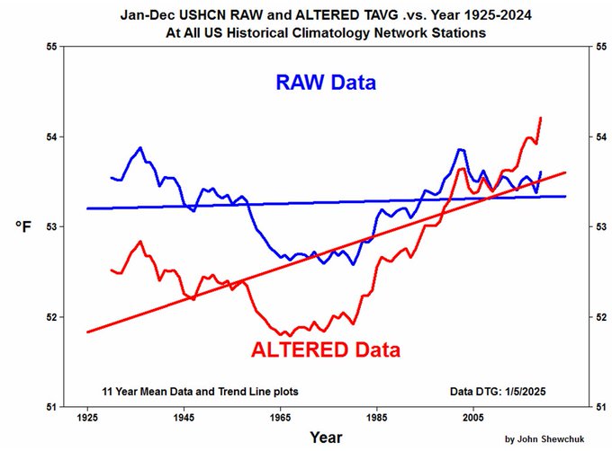
-

July 2025 Obs/Disco ... possible historic month for heat
bch2014 replied to Typhoon Tip's topic in New England
Storming in Meredith, but nothing too out of the ordinary. -

July 2025 Obs/Disco ... possible historic month for heat
NoCORH4L replied to Typhoon Tip's topic in New England
My folks are near 89/93 interchange, says traffic at a standstill almost due to violent weather. -

July 2025 Obs/Disco ... possible historic month for heat
dryslot replied to Typhoon Tip's topic in New England
Bethel-Rumford corridor now warned, Healthy cell too near Bartlett NH. -

July 2025 Obs/Disco ... possible historic month for heat
Torch Tiger replied to Typhoon Tip's topic in New England
Looks like Hubbdave gets the goods. will probably split N/S in this area, not expecting anything. -

July 2025 Discussion-OBS - seasonable summer variability
LongBeachSurfFreak replied to wdrag's topic in New York City Metro
That’s actually super ideal for fireworks. The lower dews mean less smoke clogging up the sky. -
 fixed it for you - The NOAA method is well proven for getting the DESIRED answer
 -
July 2025 Obs/Disco ... possible historic month for heat
NoCORH4L replied to Typhoon Tip's topic in New England
Will be warned soon -
July 2025 Obs/Disco ... possible historic month for heat
Torch Tiger replied to Typhoon Tip's topic in New England
congrats in advance (cia) -

July 2025 Discussion-OBS - seasonable summer variability
donsutherland1 replied to wdrag's topic in New York City Metro
There are cycles and there are also longer-term trends. For example, New York City is seeing increasing precipitation (as expected from climate change). Its cycles continue and a drier cycle will commence at some point, but the overall trend is greater annual precipitation. In contrast, parts of California and the Desert Southwest are in an aridification trend. There will be wetter cycles, but the overall trend is reduced precipitation.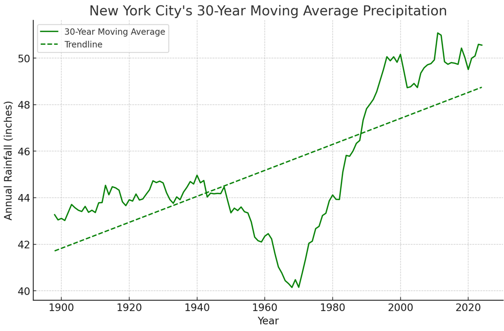
-
July 2025 Obs/Disco ... possible historic month for heat
Chrisrotary12 replied to Typhoon Tip's topic in New England
Cell by Jackson is mean. Nice meso. -
July 2025 Obs/Disco ... possible historic month for heat
Chrisrotary12 replied to Typhoon Tip's topic in New England
Make a bet? Nashua always misses -
July 2025 Obs/Disco ... possible historic month for heat
Torch Tiger replied to Typhoon Tip's topic in New England
Nashua can't miss this one. congrats -

July 2025 Obs/Disco ... possible historic month for heat
Typhoon Tip replied to Typhoon Tip's topic in New England
yup there we go nice cell near orange -
July 2025 Obs/Disco ... possible historic month for heat
dryslot replied to Typhoon Tip's topic in New England
No we don't need hail.


