All Activity
- Past hour
-
90.2 at 11am. Models ticked up to 19-19.5c or so at 850. Probably alot of 95-96s and a few 97s today
-
NBM not backing down at BDL tomorrow...13z run still throwing up 95
-
87
-

2026-2027 Strong/Super El Nino
40/70 Benchmark replied to Stormchaserchuck1's topic in Weather Forecasting and Discussion
I think you have to assume another La Nino given the consistent RONI lag. -
89/75. David dew seems high, but we muggy.
-
Hoping for some rain today. Yard needs it.
-

2026-2027 Strong/Super El Nino
Stormchaserchuck1 replied to Stormchaserchuck1's topic in Weather Forecasting and Discussion
Indian Ocean has probably warmed the most of every sea region of the globe. -
2026-2027 Strong/Super El Nino
40/70 Benchmark replied to Stormchaserchuck1's topic in Weather Forecasting and Discussion
Yea, CC is limiting the utility of traditional indexes....we need a RONI for the IOD. I bet the modern IOD readings are falsely inflated due to the rising SSTs, so you can't assume this will entirely eradicate the La Nina background. -

2026-2027 Strong/Super El Nino
LakePaste25 replied to Stormchaserchuck1's topic in Weather Forecasting and Discussion
“La Nino” pattern with the strong southern stream (relative to seasonal normals) that curves northward due to the se ridge. Could be due to the lingering warm pool that @bluewave refers to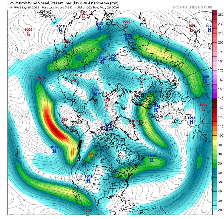
-
And we even get a Stein out of it all week!!
-
Dew is 71 LFG!!
-

2026-2027 Strong/Super El Nino
forkyfork replied to Stormchaserchuck1's topic in Weather Forecasting and Discussion
every wx discussion gets ruined by snow people. unwanted plague rats -
Yeah, 1976 was the year when the highest temp was hit in April, during the Easter heatwave, for many spots in New England, and as far south as Philly. Things turned cold very early that season, with October 1976-January 1977 being the coldest October-January on record. (The spring that followed was one of the warmest on record, despite a snow event on May 9-10.)
-
April 28, 2009 hit 89, tops for that year. In 28 years, we've had two months tying on 3 occasions and in 2010 the warmest (88°) was reached 5 times - May, July(2), August and September, hence the fractions below: APR: 1 MAY: 3.2 JUN: 10 JUL: 9.4 AUG: 3.7 SEP: 0.7 Hottest here of 93 occurred on July 3 and September 9, 2002. Low of 44, now approaching 80, but clouds have dimmed the sun. We've gone from 5% leaf-out on Friday to 50% now and climbing; might be the quickest leaf-out I've seen.
-
One underrated aspect that is going to suck about the RRFS replacing the various meso models is it runs MUCH slower
-
The NAM begging for its retirement on 8/31 to be moved up with its forecast for TSTMs across the NE tomorrow afternoon
-

Central PA Spring 2026 Discussion/Obs Thread
Voyager replied to Voyager's topic in Upstate New York/Pennsylvania
I'm finding out my thyroid is affecting the way my body handles both cold and hot extremes now. This heat is a little rough. 70s to low 80s are perfect. -
2026-2027 Strong/Super El Nino
Stormchaserchuck1 replied to Stormchaserchuck1's topic in Weather Forecasting and Discussion
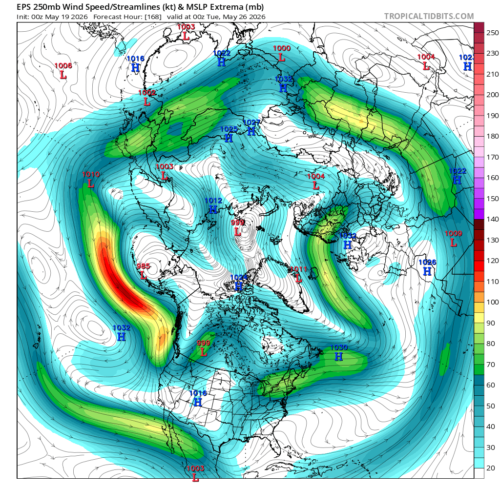
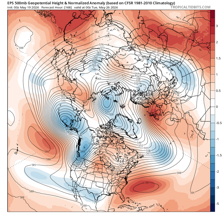
PNA just not budging with this El Nino May could be the 4th consecutive month with -pna Not really much of a consistency rolled forward, historically. -

Central PA Spring 2026 Discussion/Obs Thread
NepaJames8602 replied to Voyager's topic in Upstate New York/Pennsylvania
Agreed, not sure how anyone "sane" can say that's enjoyable.. but.... To each their own lol. -

2026-2027 Strong/Super El Nino
GaWx replied to Stormchaserchuck1's topic in Weather Forecasting and Discussion
1. Per that table, 2023 had a record high IOD for the months of Aug and Sep. 2. Keep in mind that IOD levels have had a notable longtime rise though. So, that biases more recent years toward a higher +IOD. Even the warm neutral (as opposed to El Niño) 2019 had a very strong +IOD in autumn/2nd strongest only to 1997! And as I already said, the very weak El Niño of 2018 still was able to have a strong +IOD. -

Central PA Spring 2026 Discussion/Obs Thread
Itstrainingtime replied to Voyager's topic in Upstate New York/Pennsylvania
It's 88 degrees at 10:30 in the morning. Sorry to my hot weather friends but this is ridiculous. (to me) Forecast high is now 98... -
yup...north today, south tomorrow. damn. NAM came back down to Earth too with the mlvl lapse rates...had a feeling it was a bit too aggressive with the steeper lapse rates. DCAPE not bad though...probably see some scattered wind damage reports tomorrow along that swath you mentioned
-
86/73. Dews maybe a bit high on the Davis but it’s muggy.
-
Tomorrow is a South Coast day. Probably like a BDR-PVD-PYM on south.
-
Man this is great stuff. Look how excited everyone is.