
All Activity
- Past hour
-
 Chigger?
 -
Average high in Miles city is 90 though.. didn't realize that but still
-

2026-2027 Super El Nino
LakePaste25 replied to Stormchaserchuck1's topic in Weather Forecasting and Discussion
July should be our first “fully coupled” month. Come August, will need to find a site that plots omega since NCAR is discontinued. Would like to compare it to past super nino July’s. -
It's 115 in Miles City Montana right now.. that's nuts!
-
2026-2027 Super El Nino
LakePaste25 replied to Stormchaserchuck1's topic in Weather Forecasting and Discussion
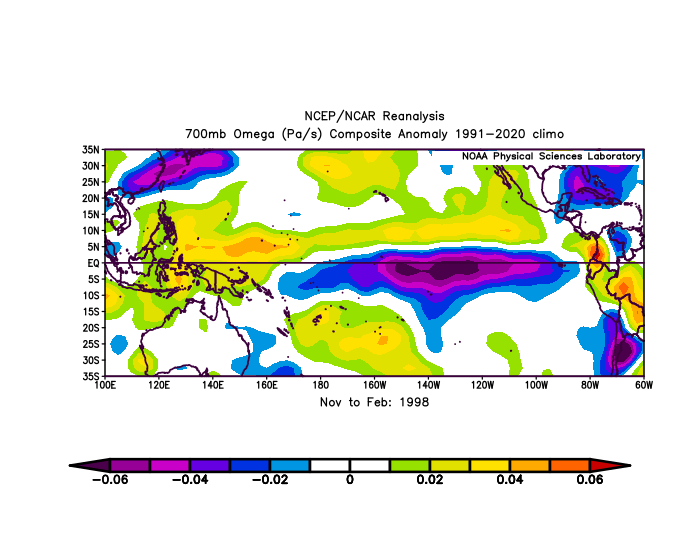
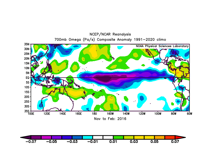
Yeah…if you look at 2016, the convection is very far west. Should be east of that IMO although we will really put that theory to the test if it’s “not cool enough” to stop convection there.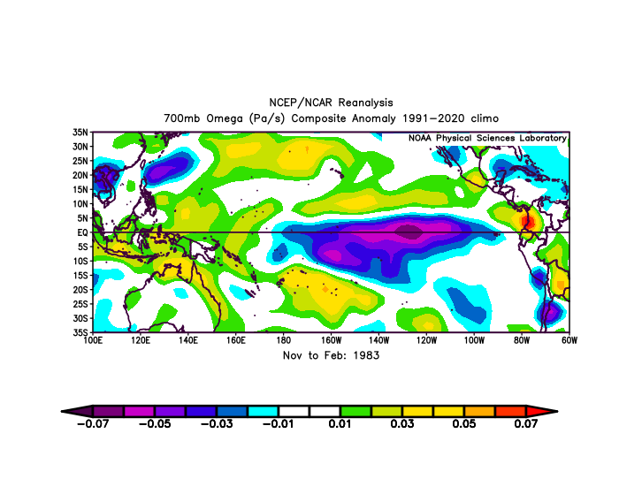
-
Fun watching the showers/t-storms rolling WEST in a line from Front Royal to almost Lynchburg this afternoon, lol. Everything out this way seems to just be stationary, MAYBE a slight WSW movement. Although I've only had .25-.30 here since noon, 10 miles to my south has had 2-4 INCHES of rain and a FFW until 7:45 pm.
-

2026-2027 Super El Nino
40/70 Benchmark replied to Stormchaserchuck1's topic in Weather Forecasting and Discussion
1982? -
2026-2027 Super El Nino
LakePaste25 replied to Stormchaserchuck1's topic in Weather Forecasting and Discussion
I’m leaning towards a more canonical super Nino response than 15-16, but not quite to the level of 97-98. -
Well they won, but lose Blaze to a broken hand. Orioles can't have nice things.
-
2026-2027 Super El Nino
40/70 Benchmark replied to Stormchaserchuck1's topic in Weather Forecasting and Discussion
2015-2016 has been referenced quite frequently for it's pretty abrupt transition to some wintry interludes throughout the NE during the second half...I wouldn't say they aren't remembered. It's just that they weren't as anomalous or long-lasting as the warmth in December, so the season was mild in the aggregate. I wouldn't at all be surprised to see something similar this year. -

2026-2027 Super El Nino
raindancewx replied to Stormchaserchuck1's topic in Weather Forecasting and Discussion
2015-16 actually had several very cold periods nationally, it's just no one remembers because they never mapped cleanly on to calendar months. I had 5 inches of snow in December 2015, give or take - but it was so cold it didn't melt for three weeks in the shadows. On these images, light blue is 1F to 3F below average, and dark blue 3F to 5F below average. The light purple spots are 5F to 7F. That super heat wave at the end of January flushed out most of the cold in the North. -

2026-2027 Super El Nino
GaWx replied to Stormchaserchuck1's topic in Weather Forecasting and Discussion
Chris, Keep in mind that the mild 2015-6 avg. in the E US was so heavily dominated by the warmest Dec on record in many locations. I assume you realize that Jan-Feb wasn’t mild in the E US outside of New England with Jan actually being chilly VA S and SW: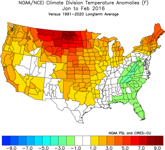
-
.thumb.jpg.6a4895b2a43f87359e4e7d04a6fa0d14.jpg)
Central PA Summer 2026 Discussion/Obs Thread
Yardstickgozinya replied to Voyager's topic in Upstate New York/Pennsylvania
According to last night's spc 4 AM update, some of the overlaps deterministic guidance was originally picking up on are in jeopardy. Timing issues. - Today
-

2026-2027 Super El Nino
bluewave replied to Stormchaserchuck1's topic in Weather Forecasting and Discussion
Yeah, 1997-1998 was the last canonical super El Niño. The La Niña-like influence in December 2015 merging with the Nino standing wave was through the MJO 5. The precipitation impacts were also different from previous super El Niños. In 2023-2024 we saw another MJO excursion through the IO and MC during January when the Southeast ridge emerged. The pattern since May has seen the strongest heat and ridging across the CONUS outside a neutral or La Niña summer with a strong -PDO influence. The summer -PDO drop and +AMO increase has been a common feature during the 2020s. So there are multiple ways for competing or overlapping marine heatwaves to interact with an El Niño. This summer is the most extreme example of a dominant -PDO pattern across the CONUS at the same time a record super El Niño is strengthening. The 2015-2016 and 2023-2024 super El Niños showed that the interaction actually resulted in warmer winters conditions than 1997-1998. Both winters featured the El Niño ridge south of Hudson Bay building down further into the Eastern U.S. than normal. But even if this event found a way to have the canonical 1997-1998 response, a +3.9 event alone without any -PDO or MC forcing influence could easily surpass 1997-1998 in spots for warmth. Ridges have been getting stronger than troughs regardless of whether we have an El Niño or La Niña. -
 I do think we have to watch Wednesday for some strong storms, particularly south of the Pike, despite NAM showing zilch for QPF.
 -
To his credit, Joe Bastardi made quite a good call on Arthur starting way back in late April when he projected MJO to go into phase 8 in early June and thus forecasted TCG in the Gulf based on climo of phase 8. He was about a week too early, which he admitted and he even admitted he got lucky. It actually formed when the MJO moved from 8 to 1. Regardless, I’m giving him credit, especially since I sometimes criticize him for being wrong. I’m mentioning this now because during the last couple of days, he’s been talking about the MJO returning to phase 8 for most of the 2nd half of July on the Euro (JMA agrees) although the GEFS holds it back and only barely reaches 8 before bringing it back into 7. So, based on the Euro, JB is sort of predicting Gulf tropical mischief potential again later this month based on July phase 8 climo being similar to June phase 8. On Friday he showed the Euro AI with a Gulf TS in the E Gulf on July 22nd. We’ll see.
-
To his credit, Joe Bastardi made quite a good call on Arthur starting way back in late April when he projected MJO to go into phase 8 in early June and thus forecasted TCG in the Gulf based on climo of phase 8. He was about a week too early, which he admitted and he even admitted he got lucky. It actually formed when the MJO moved from 8 to 1. Regardless, I’m giving him credit, especially since I sometimes criticize him for being wrong. I’m mentioning this now because during the last couple of days, he’s been talking about the MJO returning to phase 8 for most of the 2nd half of July on the Euro (JMA agrees) although the GEFS holds it back and only barely reaches 8 before bringing it back into 7. So, based on the Euro, JB is sort of predicting Gulf tropical mischief potential again later this month based on July phase 8 climo being similar to June phase 8. On Friday he showed the Euro AI with a Gulf TS in the E Gulf on July 22nd. We’ll see.
-

2026-2027 Super El Nino
michsnowfreak replied to Stormchaserchuck1's topic in Weather Forecasting and Discussion
I dont care if Nino peaks at 5.0...I really only care about the weather in my backyard. I mean, most weather weenies do. Any early thoughts for Michigan? Ive been thinking 2015-16 is a decent starting point but I've also been looking more into 1877-78. -
2026-2027 Super El Nino
michsnowfreak replied to Stormchaserchuck1's topic in Weather Forecasting and Discussion
When last winters cold was becoming imminent is when I first remember the bizarre slew of posts in different languages to say it wouldn't stay cold. When snowman cant find an English tweet to say warm is when winter lovers knew it was game on. -
2026-2027 Super El Nino
GaWx replied to Stormchaserchuck1's topic in Weather Forecasting and Discussion
Unfortunately, TAO doesn’t have buoy data for 160W. It has them at 170W and 155W. For July of 2015, TAO does confirm that 30C didn’t make it as far E as 155W. But it did make it to 170W at 2N and 2S though not to 5S: 2N: avg ~30.0C https://www.pmel.noaa.gov/cache-tao/sy1/deliv/data3551221/sst2n170w_dy.ascii 2S: avg ~30.2C https://www.pmel.noaa.gov/cache-tao/sy1/deliv/data3551221/sst2s170w_dy.ascii But it was <30C (~29.8C) at 5S: https://www.pmel.noaa.gov/cache-tao/sy1/deliv/data3551221/sst5s170w_dy.ascii ———————————— How does July 2026 compare to July 2015 at 170W? 2026 at 2N: avg ~30.35C or ~0.35C warmer than 2015 https://www.pmel.noaa.gov/cache-tao/sb1/deliv/data2259457/sst2n170w_dy.ascii 2026 at 2S: avg ~30.60C or ~0.40C warmer than 2015 https://www.pmel.noaa.gov/cache-tao/sb1/deliv/data2259457/sst2s170w_dy.ascii 2026 at 5S: N/A..so can’t compare ——————— Summary: TAO confirms that 2026 is currently notably warmer (~0.4C) than July 2015 at 170W. But the avg tropical SST has also warmed since 2015. But it hasn’t warmed by as much as it’s closer to 0.25C warming, which tells me that July 2026 is warmer than July 2015 at 170W by 0.15C even on a relative basis. -
2026-2027 Super El Nino
michsnowfreak replied to Stormchaserchuck1's topic in Weather Forecasting and Discussion
1997-98 had a cold November with multiple snowfalls. It was definitely a front loaded winter. -
 We lived in Gardiner from late October 1985 thru mid-May 1998. August 1988 compared to averages for our 13 Augusts had 3 levels: 1-13: 74° nearly 8° AN 14-18: 65° average 19-31: 59° 3.5° BN Modest temps compared to the real hot spots (instrument was within some pines), but impressive averages.
 -
Has anyone seen these before? They’re incredibly tiny orange big/insect…whatever. Sitting outside and feeling random spots of itchiness and I’ll see a super small orange looking thing and I’m guessing they bite or something because I’ll have a tiny red bite mark. No clue where they are coming from or what they are. They’re like those tiny red bugs that leave a blood dot but these are orange and even smaller.
-
 Yeah. As I’ve gotten older, I yearn for more of these days.
 -
2026-2027 Super El Nino
40/70 Benchmark replied to Stormchaserchuck1's topic in Weather Forecasting and Discussion
Exactly.





