All Activity
- Past hour
-
Wind really picking up!! Feels cold out now
-
i’m just on the eastern edge of the warned storm in Jefferson County. the wind sounded like a freight train for a bit. i’m happy to be fringed.
-
.thumb.jpg.6a4895b2a43f87359e4e7d04a6fa0d14.jpg)
Central PA Spring 2025
Yardstickgozinya replied to canderson's topic in Upstate New York/Pennsylvania
I'm certainly no ace on the meso analysis but I'm not seeing any storm relative helicity off the charts over harrisburg but LNS dose have higher values atm. -
I think that would be a safe bet. A lot more damage from this than from the strong tropical storm in August of a few years ago. And this all occurred in about five minutes.
-
Sun shining in the western sky and rolling thunder from the warned cell brushing by to my southeast. Enough rain so far that the sidewalk just caved.
-
Severe Thunderstorm Watch until Sat 10:00 pm THE NATIONAL WEATHER SERVICE HAS ISSUED SEVERE THUNDERSTORM WATCH 219 IN EFFECT UNTIL 10 PM EDT THIS EVENING FOR THE FOLLOWING AREAS THE DISTRICT OF COLUMBIA IN MARYLAND THIS WATCH INCLUDES 11 COUNTIES IN CENTRAL MARYLAND ANNE ARUNDEL, HOWARD MONTGOMERY PRINCE GEORGES IN NORTH CENTRAL MARYLAND CARROLL, FREDERICK WASHINGTON IN NORTHEAST MARYLAND CECIL IN NORTHERN MARYLAND BALTIMORE BALTIMORE CITY HARFORD IN VIRGINIA THIS WATCH INCLUDES 20 COUNTIES IN CENTRAL VIRGINIA CITY OF FREDERICKSBURG GREENE, ORANGE SPOTSYLVANIA IN NORTHERN VIRGINIA ARLINGTON CITY OF ALEXANDRIA CITY OF FAIRFAX CITY OF FALLS CHURCH CITY OF MANASSAS CITY OF MANASSAS PARK CULPEPER, FAIRFAX FAUQUIER, LOUDOUN PRINCE WILLIAM STAFFORD IN NORTHWEST VIRGINIA CLARKE, MADISON RAPPAHANNOCK, WARREN IN WEST VIRGINIA THIS WATCH INCLUDES 1 COUNTY IN PANHANDLE WEST VIRGINIA JEFFERSON THIS INCLUDES THE CITIES OF ABERDEEN, ALEXANDRIA, ANNAPOLIS, ARLINGTON, ARNOLD, ASPEN HILL, BALLENGER CREEK, BALTIMORE, BEL AIR, BERRYVILLE, BETHESDA, BOWIE, CAMP SPRINGS, CATONSVILLE, CHANTILLY, CHARLES TOWN, CLINTON, COLLEGE PARK, COLUMBIA, CULPEPER, DUNDALK, EDGEWOOD, ELDERSBURG, ELKTON, ELLICOTT CITY, ESSEX, FAIRFAX, FALLS CHURCH, FALLSTON, FALMOUTH, FREDERICK, FREDERICKSBURG, FRONT ROYAL, GAITHERSBURG, GERMANTOWN, GLEN BURNIE, GORDONSVILLE, GREENBELT, HAGERSTOWN, HAVRE DE GRACE, HERNDON, JOPPATOWNE, LAUREL, LEESBURG, MADISON, MANASSAS, MANASSAS PARK, MCLEAN, ODENTON, ORANGE, PARKVILLE, PIKESVILLE, POTOMAC, RANDALLSTOWN, RESTON, ROCKVILLE, SEVERN, SEVERNA PARK, SHEPHERDSTOWN, SILVER SPRING, SOUTH GATE, SPOTSYLVANIA COURTHOUSE, STANARDSVILLE, STERLING, SUITLAND-SILVER HILL, TOWSON, WARRENTON, WASHINGTON, WASHINGTON, WESTMINSTER, AND WOODBRIDGE.
-
Post some pics when can
-
Whoa! You guys got rocked! That bow went right over Monson . How strong do you estimate gusts? Sounds like 65/70 type damage ?
-
-
That’s not severe either
-
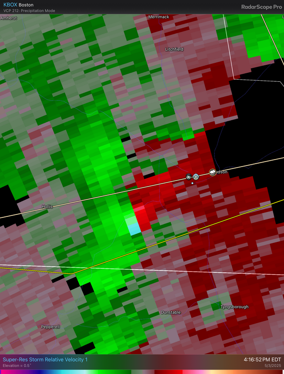
Near Owings Mills, MD Rotation - Cell DIX_W1
-

-
Three Severe Thunderstorm Warnings thus far.
-
I was looking at that but it was in between the two cores.
-
Gonna miss to your south
-
Light, gentle shower and a few distant rumbles. Under a warning though so trying to stay safe
-
We have 4 cars
-
So you have a driveway, and garage, but park in the street?
-
I’ve felt like BOX has run hot for years
-
Chris Im about 3 miles north of you, .25" in about 8 mins. ( so far day total @ .43")
-
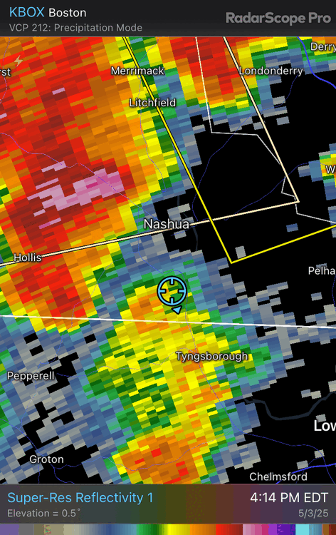
Put your location on radar scope
-
Almost some fun there
-
Damage in Hampton NH part deux soon! ARe BOX radar reflectivities running a bit hot? Either that or GYX is running cool.
-
Severe Thunderstorm Watch issued for our whole area .
-
I hate where I live.