All Activity
- Past hour
-
0Z Icon is again OTS.
-

September 2025 OBS-Discussion centered NYC subforum
FPizz replied to wdrag's topic in New York City Metro
-

Potential Tropical Cyclone Nine
Coach McGuirk replied to WxWatcher007's topic in Tropical Headquarters
Damn it, don't you watch the X-Files? -
want to believe what?
-
Yeah the writing was on the wall pretty quickly this morning, unabated RI was almost a guarantee.@WxWatcher007was correctly calling for this to be the season of the SW Atlantic… once Erin’s cold pool rebounded, that zone has become rocket fuel once again
-
A stall off the coast is fine with us in Helene ravaged WNC.
-

Potential Tropical Cyclone Nine
WxWatcher007 replied to WxWatcher007's topic in Tropical Headquarters
Humberto is a little west of track and is now forecast to become our second category five hurricane of the season. -
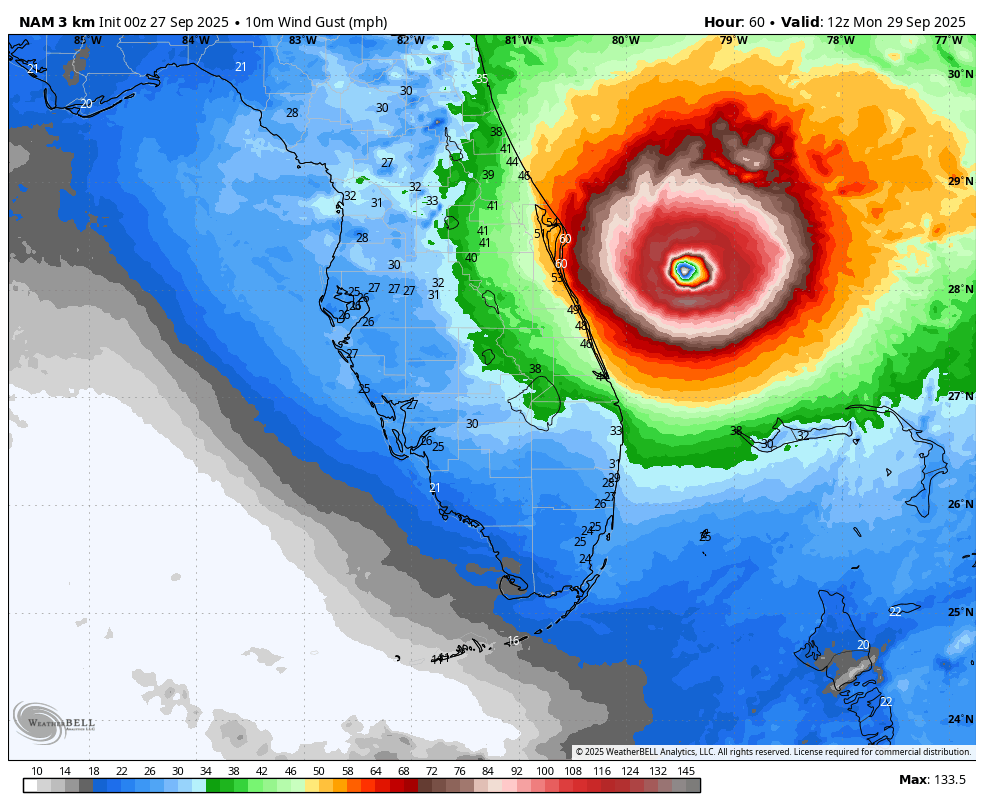
WB 18Z 3K at hr 60 has a hurricane just off the coast of Florida....

-
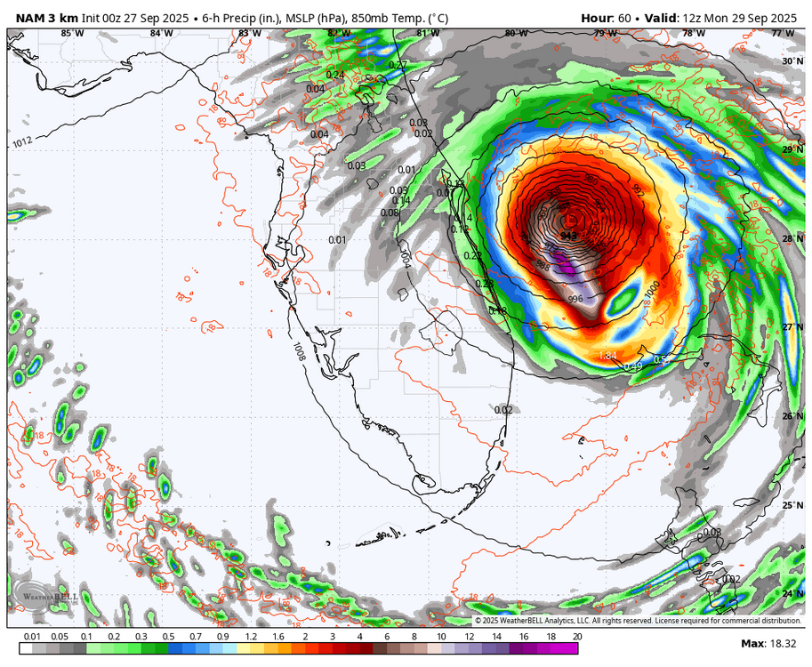
Hurricane Humberto Discussion Number 10 NWS National Hurricane Center Miami FL AL082025 1100 PM AST Fri Sep 26 2025 Humberto has continued to intensify rapidly this evening. The eye temperature has increased to 15C and the eyewall white ring (-73C) is nearly closed. A 2137 UTC WSFM-1 HiRes microwave pass indicated that a concentric ring was developing about 65 nm from the eye. The initial intensity is raised to 125 kt and is close to the UW-CIMSS ADT of T6.4 and above the constrained subjective Dvorak intensity estimates from TAFB and SAB. All intensity contributions, low shear, warm waters, and ample mid-level moisture, appear conducive for Humberto to intensify rapidly during the next 12-24 hours. DTOPS guidance indicates a high probability of RI during the next 12-24 hours, and the latest official intensity forecast follows suit, bringing Humberto to a peak intensity of 140 kt Saturday night. By the 36 hour period, however, inner-core fluctuations as a result of eyewall replacement cycles (ERC) are possible, and it's difficult to forecast the exact timing. It's worth mentioning, however, that the UW-CIMSS M-PERC (Microwave-based Probability of Eyewall Replacement Cycle) statistical model is predicting a 61 percent of onset. By mid-next week, increasing vertical shear spreading over Humberto should induce a gradual weakening trend. At the same time, while it passes west of Bermuda, a significant expansion in the surface wind field will likely occur. The NHC intensity forecast is just above the previous forecast through the 36 hour period, and closely follows a blend of the HCCA consensus and the HAFS/HWRF/HMON hurricane models. Humberto has taken a trochoidal jog to the left of the track this evening, likely due to the rapid intensification event. The initial motion is estimated to be slightly south of due west, or 265/6 kt. Humberto is expected to move slowly toward the west or west-northwest during the next day or so in the easterly steering flow provided by mid-tropospheric high pressure located to the north of the cyclone and just east of Bermuda. Around the 48 hour period, or Sunday evening, a northwestward turn with some reduction in forward speed is forecast while the above-mentioned high pressure weakens and shifts eastward. By day 4, Humberto should commence a rather abrupt turn northward and northeastward in response to a major shortwave upper-level trough amplifying and moving out of northeastern Canada and into the northwestern Atlantic. The official track forecast is located just to the left of the previous advisory, primarily due to the initial motion left of track, and lies between the HCCA corrected consensus and the Google DeepMind ensemble model. NOAA buoy 41044, located about 38 n mi southwest of the center, has reported falling pressure,sustained tropical-storm-force winds, gusts just below hurricane-force and 17 ft seas. FORECAST POSITIONS AND MAX WINDS INIT 27/0300Z 22.1N 58.7W 125 KT 145 MPH 12H 27/1200Z 22.2N 59.8W 135 KT 155 MPH 24H 28/0000Z 22.7N 61.6W 140 KT 160 MPH 36H 28/1200Z 23.6N 63.5W 135 KT 155 MPH 48H 29/0000Z 24.8N 65.3W 130 KT 150 MPH 60H 29/1200Z 26.2N 67.0W 125 KT 145 MPH 72H 30/0000Z 27.9N 68.2W 115 KT 130 MPH 96H 01/0000Z 32.1N 68.2W 100 KT 115 MPH 120H 02/0000Z 36.0N 62.0W 90 KT 105 MPH $$ Forecaster Roberts
-
WOW Humberto now forecast to become a cat 5
-
Good to see the Euro AI take up the annual challenge of throwing tropical up the bay
- Today
-
Tucked.
-
Potential Tropical Cyclone Nine
Coach McGuirk replied to WxWatcher007's topic in Tropical Headquarters
It's been such a dead season, I want to believe. -
Potential Tropical Cyclone Nine
WxWatcher007 replied to WxWatcher007's topic in Tropical Headquarters
Yeah we have a long way to go… -
-
I keep seeing 2013-14 as an analog. Saw a story a couple days ago that said the North Pacific especially behaving very similarly.
-
jumping the gun a bit to early..
-
Ai models won big with Erin track days before everyone jumped on board... . Icon took a big win imo on that storm as well, which is crazy to say lol
-
Potential Tropical Cyclone Nine
Coach McGuirk replied to WxWatcher007's topic in Tropical Headquarters
What's the A.I. modelz? -

September 2025 OBS-Discussion centered NYC subforum
Cfa replied to wdrag's topic in New York City Metro
Made it up to 87 here, I wish this happened tomorrow (Saturday) instead. This year has really been a snoozefest on all fronts, the only exception being the 100+ degree heat in June and July. -
Even with this half scan, Humberto is an absolute beast.
-
AI ftw?
-

Potential Tropical Cyclone Nine
NC US Geological Survice replied to WxWatcher007's topic in Tropical Headquarters
Doesn't have its act together. I'm buying all the shares of OTS. All hail the A.I. modelz. (AND Icon/Ukie) Edit: i know there're a lot of solutions on the table. Just following the evening hype train right now. Til tmrw folks. -

September 2025 OBS-Discussion centered NYC subforum
anthonymm replied to wdrag's topic in New York City Metro
Wasted the cold air in august and first half of September. I guess it made what is usually the worst part of summer more tolerable but now we have typical late august temps happening in late september-early oct. Fall's taking a break for the foreseeable future. -
September 2025 OBS-Discussion centered NYC subforum
anthonymm replied to wdrag's topic in New York City Metro
What is causing the ridiculously consistent +8 F temps above normal literally every single day? Is it just the EPO? It's a january 2023 torch-like pattern.