All Activity
- Past hour
-
Well let's hope this one is different because I do think that this November starts out cold but goes mild and may average out to above average in temps. But as we've all talked about these winter patterns tend to last 4 to 6 weeks so mild November, cold December, mild January and possibly cold February? Obviously the blocking is a crapshoot and there is no way of really forecasting that with any kind of accuracy. But I do like the PV in a constant weakened state and we've already seen that this Fall. Oh the joys of this hobby lol.
-

2025 Atlantic Hurricane Season
Windspeed replied to BarryStantonGBP's topic in Tropical Headquarters
Melissa has now pushed us above average seasonal ACE for the date (117.1 vs 113.7) and will most likely push the Atlantic above seasonal average of 122.5 for the year by the time it dissipates. Granted, if you would have told me going into the season that we would experience three Category 5 hurricanes and only be around annual average mean ACE, I'd have laughed you off of the forum. It's been a weird season. Interestingly, all other basins are currently below their seasonal ACE values for the date as well. Though I suspect the EPAC will probably pump out a few more TCs to get above its seasonal ACE values before all is said and done. -
It's not going to happen every time but looking back from the 1930s-2021ish it was about 60-65 percent of the time. Warm Novembers, more often than not, led to unremarkable winters, but not always. Cold Novembers went on to feature major outbreaks of winter weather at a higher than usual rate, but not always. 2013-14, and 2014-15 were both BN Novembers and both great winters (if you like snow/cold outbreaks). Nov 2015, 2016 were well AN and the winter of 16 was good but 17 was blah. Nov 2021 was well BN. 2022 was very cold/snowy, especially from my area and west across our forum region. I was -4 for Jan 2022 with 15+ inches of snow for the month. Going back, Nov 1995 was -4 here, Jan/Feb 96 were epic. Nov 1993 was -1.5, Jan featured heavy snow, ice, and -15 type temps, Nov 1984 was -3, Jan 85 was legendary, and Feb was great too, Nov 1976 was -9, Jan/Feb '77 were non-stop winter here, Nov 1967 was -3, Jan and Feb were both well BN, Feb -11. Nov 1959 was -2, snowiest winter in Tn history Jan-March '60. Almost every epic winter we've had in the last 70 years had a cold Nov, except three. Nov 2019 was cold, and winter 2019-20 was a dud, so a cold November isn't a lock, it's a noticeable lean though. There are generally more cases of a good winter following a warmer Nov than a dud following a cold November, at least imby.
-

Major Hurricane Melissa - 903mb - 175mph
WxSynopsisDavid replied to GaWx's topic in Tropical Headquarters
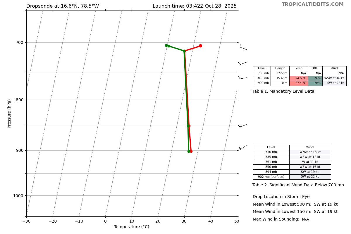
That 902mb measurement also had 22kt winds. That would make it 899mb. Really does suck that we don’t have a recon flight making another pass.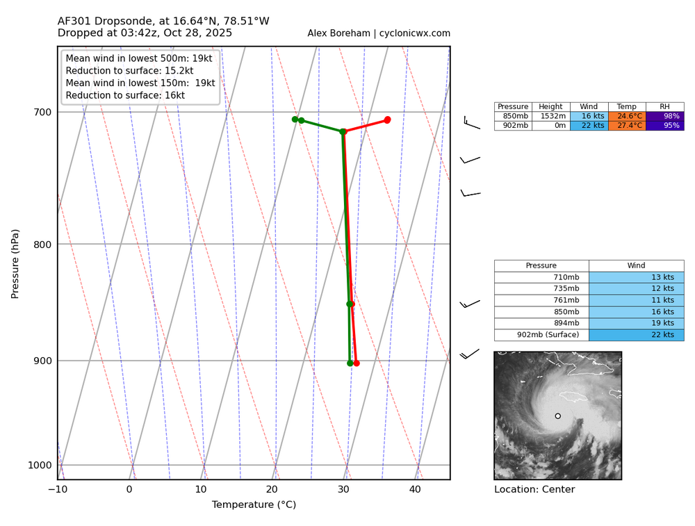
-
I received 0.20” since last night bringing me to 2.75” MTD, which is only modestly below normal.
-

Major Hurricane Melissa - 903mb - 175mph
WxWatcher007 replied to GaWx's topic in Tropical Headquarters
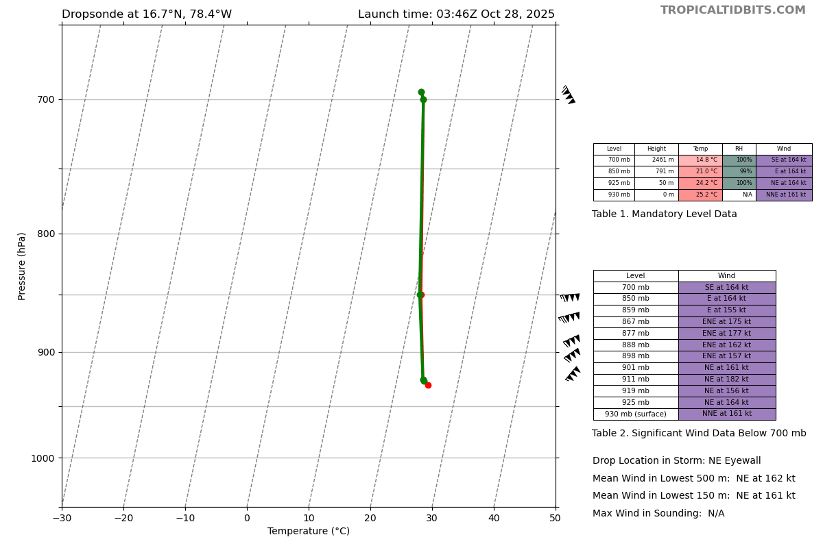
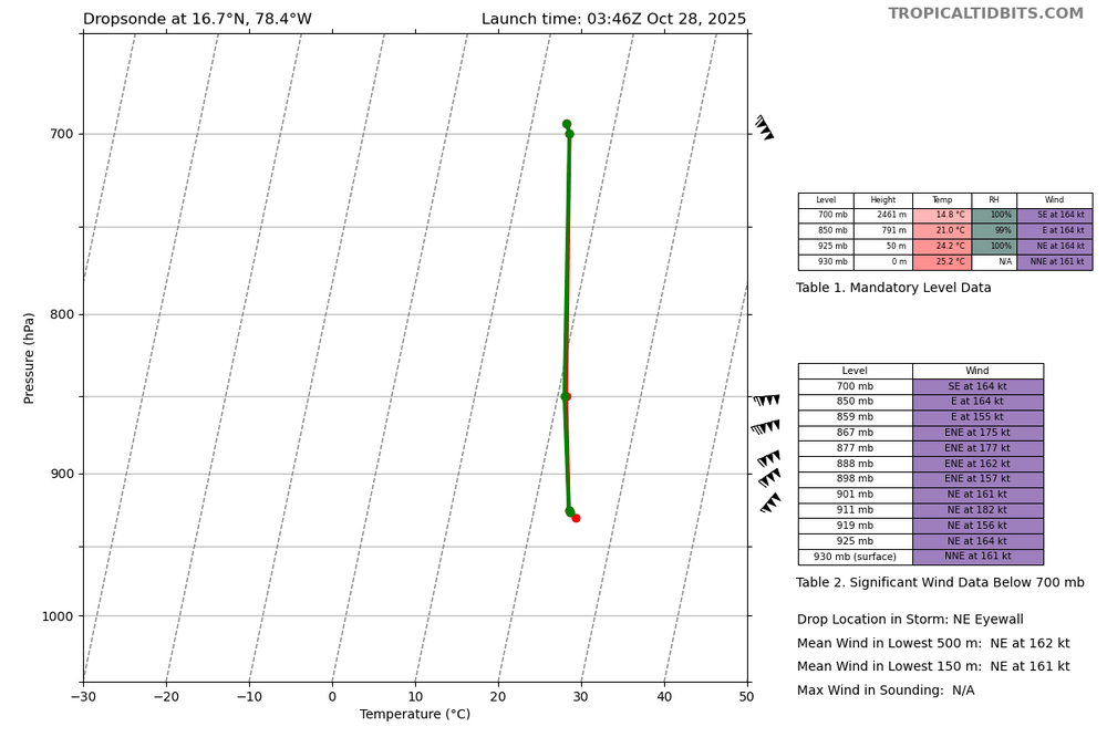
Likely the last VDM of the night. The eye size has been remarkably consistent. Product: Air Force Vortex Message (URNT12 KNHC)Transmitted: 28th day of the month at 5:02ZAgency: United States Air ForceAircraft: Lockheed WC-130J Hercules with reg. number AF96-5301Storm Name: MelissaStorm Number & Year: 13 in 2025 (flight in the North Atlantic basin)Mission Number: 22Observation Number: 36 ( See all messages of this type for this mission. )A. Time of Center Fix: 28th day of the month at 4:36:00ZB. Center Fix Coordinates: 16.73N 78.49WB. Center Fix Location: 142 statute miles (229 km) to the SW (231°) from Kingston, Jamaica.C. Minimum Height at Standard Level: 2,236m (7,336ft) at 700mbD. Minimum Sea Level Pressure: 903mb (26.67 inHg)E. Dropsonde Surface Wind at Center: From 185° at 11kts (From the S at 13mph)F. Eye Character: ClosedG. Eye Shape & Diameter: Circular with a diameter of 10 nautical miles (12 statute miles)H. Estimated (by SFMR or visually) Maximum Surface Wind Inbound: 156kts (179.5mph)I. Location & Time of the Estimated Maximum Surface Wind Inbound: 4 nautical miles to the N (8°) of center fix at 4:34:30ZJ. Maximum Flight Level Wind Inbound: From 99° at 149kts (From the E at 171.5mph)K. Location & Time of the Maximum Flight Level Wind Inbound: 5 nautical miles to the N (6°) of center fix at 4:34:00ZL. Estimated (by SFMR or visually) Maximum Surface Wind Outbound: 157kts (180.7mph)M. Location & Time of the Estimated Maximum Surface Wind Outbound: 6 nautical miles to the SSE (150°) of center fix at 4:38:00ZN. Maximum Flight Level Wind Outbound: From 242° at 162kts (From the WSW at 186.4mph)O. Location & Time of the Maximum Flight Level Wind Outbound: 6 nautical miles to the SSE (150°) of center fix at 4:38:00ZP. Maximum Flight Level Temp & Pressure Altitude Outside Eye: 12°C (54°F) at a pressure alt. of 3,054m (10,020ft)Q. Maximum Flight Level Temp & Pressure Altitude Inside Eye: 23°C (73°F) at a pressure alt. of 3,058m (10,033ft)R. Dewpoint Temp (collected at same location as temp inside eye): 12°C (54°F)R. Sea Surface Temp (collected at same location as temp inside eye): Not AvailableS. Fix Determined By: Penetration, Radar, Wind, Pressure and TemperatureS. Fix Level: 700mbT. Navigational Fix Accuracy: 0.02 nautical milesT. Meteorological Accuracy: 1 nautical mileRemarks Section: Maximum Flight Level Wind: 165kts (~ 189.9mph) which was observed 7 nautical miles to the ENE (58°) from the flight level center at 3:47:00Z -
Major Hurricane Melissa - 903mb - 175mph
WxWatcher007 replied to GaWx's topic in Tropical Headquarters
Thought it had a chance but I guess it leveled out. -

Major Hurricane Melissa - 903mb - 175mph
Floydbuster replied to GaWx's topic in Tropical Headquarters
Reading around, I see that Hurricane Melissa could be the return period storm for the October 1780 "Savanna la Mar hurricane". 3,000 deaths were attributed to the storm just a week or so before the deadliest hurricane in Atlantic History hit the eastern Caribbean. Note the similar track. I wonder if Melissa is the 245 year return period storm for Jamaica. -

Major Hurricane Melissa - 903mb - 175mph
hawkeye_wx replied to GaWx's topic in Tropical Headquarters
Final recon pass is 902 mb.... not going to get sub-900 for now. - Today
-
Mind boggling. There are certain systems that defy the norms. This is def one of them. Not sure people are prepared for the scenes that will be coming out of Jaimaca. They've dogged the bullet so many times. Not this one.
-
Major Hurricane Melissa - 903mb - 175mph
WxWatcher007 replied to GaWx's topic in Tropical Headquarters
Agree. Probably somewhere between 898-901mb and 155-160kt. Really glad they're going in for another pass. -
Intermediate at 2 eastern 1 central
-
Major Hurricane Melissa - 903mb - 175mph
Floydbuster replied to GaWx's topic in Tropical Headquarters
I am guessing about 180-185 mph is quite possibly the current intensity. -
Major Hurricane Melissa - 903mb - 175mph
hawkeye_wx replied to GaWx's topic in Tropical Headquarters
It does appear recon is going in for one more pass. -

Major Hurricane Melissa - 903mb - 175mph
Radtechwxman replied to GaWx's topic in Tropical Headquarters
They going to do an intermediate advisory or wait till next main one at 5am? -
Major Hurricane Melissa - 903mb - 175mph
Floydbuster replied to GaWx's topic in Tropical Headquarters
So would Melissa be 190 mph sustained now? -
Major Hurricane Melissa - 903mb - 175mph
WxWatcher007 replied to GaWx's topic in Tropical Headquarters
Not sure off the top of my head. -
Another thing to be reminded of... Much of Jamaica is well above sea level. For example, Mandeville (which could get raked by the eastern eyewall) has a population of 47,000 people or so and is at an elevation of 620 meters (2,000 feet). So I would absolutely expect higher gusts in those locations
-
Major Hurricane Melissa - 903mb - 175mph
WxWatcher007 replied to GaWx's topic in Tropical Headquarters
Product: Air Force Vortex Message (URNT12 KNHC)Transmitted: 28th day of the month at 4:06ZAgency: United States Air ForceAircraft: Lockheed WC-130J Hercules with reg. number AF96-5301Storm Name: MelissaStorm Number & Year: 13 in 2025 (flight in the North Atlantic basin)Mission Number: 22Observation Number: 28 ( See all messages of this type for this mission. )A. Time of Center Fix: 28th day of the month at 3:42:00ZB. Center Fix Coordinates: 16.65N 78.52WB. Center Fix Location: 147 statute miles (237 km) to the SW (230°) from Kingston, Jamaica.C. Minimum Height at Standard Level: 2,247m (7,372ft) at 700mbD. Minimum Sea Level Pressure: 902mb (26.64 inHg)E. Dropsonde Surface Wind at Center: From 220° at 22kts (From the SW at 25mph)F. Eye Character: ClosedG. Eye Shape & Diameter: Circular with a diameter of 10 nautical miles (12 statute miles)H. Estimated (by SFMR or visually) Maximum Surface Wind Inbound: 164kts (188.7mph)I. Location & Time of the Estimated Maximum Surface Wind Inbound: 3 nautical miles to the N (4°) of center fix at 3:40:30ZJ. Maximum Flight Level Wind Inbound: From 97° at 152kts (From the E at 174.9mph)K. Location & Time of the Maximum Flight Level Wind Inbound: 4 nautical miles to the N (4°) of center fix at 3:40:00ZL. Estimated (by SFMR or visually) Maximum Surface Wind Outbound: 160kts (184.1mph)M. Location & Time of the Estimated Maximum Surface Wind Outbound: 6 nautical miles to the ENE (58°) of center fix at 3:46:30ZN. Maximum Flight Level Wind Outbound: From 154° at 165kts (From the SSE at 189.9mph)O. Location & Time of the Maximum Flight Level Wind Outbound: 7 nautical miles to the ENE (58°) of center fix at 3:47:00ZP. Maximum Flight Level Temp & Pressure Altitude Outside Eye: 10°C (50°F) at a pressure alt. of 3,052m (10,013ft)Q. Maximum Flight Level Temp & Pressure Altitude Inside Eye: 22°C (72°F) at a pressure alt. of 3,049m (10,003ft)R. Dewpoint Temp (collected at same location as temp inside eye): 14°C (57°F)R. Sea Surface Temp (collected at same location as temp inside eye): Not AvailableS. Fix Determined By: Penetration, Radar, Wind, Pressure and TemperatureS. Fix Level: 700mbT. Navigational Fix Accuracy: 0.02 nautical milesT. Meteorological Accuracy: 1 nautical mileRemarks Section: Maximum Flight Level Wind: 165kts (~ 189.9mph) which was observed 7 nautical miles to the ENE (58°) from the flight level center at 3:47:00Z -

Major Hurricane Melissa - 903mb - 175mph
Maestrobjwa replied to GaWx's topic in Tropical Headquarters
When's the last time that happened this close to landfall? -
NE Eyewall Sonde. 160(!) knot surface winds?
-
Rumor is they're gonna do one more pass.
-
Major Hurricane Melissa - 903mb - 175mph
WxWatcher007 replied to GaWx's topic in Tropical Headquarters
That was a big time dropsonde in the NE eyewall. Given the pressure falls and FL wind this is probably stronger than the current advisory. -
Major Hurricane Melissa - 903mb - 175mph
hawkeye_wx replied to GaWx's topic in Tropical Headquarters
Ugh.... I was hoping for 899 mb on this final recon pass. The FL wind is also 165 kts now.