All Activity
- Past hour
-
Where is the DGEX when you need it! 168 hr NAM...right!
-
Ha…I was gonna say. You know where to find every model.
-
Yes, PDS - particularly dangerous situation. I am just talking about how blizzard and ice storm warnings will have this label soon as an option.
-

E PA/NJ/DE Summer 2026 Obs/Discussion
Birds~69 replied to PhiEaglesfan712's topic in Philadelphia Region
Boy, this worked out well (cha-ching) for PECO workers w/the impending heat wave and possible power outages. Bargaining chips... 80F/DP 69F https://6abc.com/post/peco-workers-go-strike-july-4-ibew-local-614-officials-say/19380766/ -
i meant 12z
-
-
Days like this are usually reserved for winter storm fails.
-
Heat watches up for 5th period ... ? huh
-
GFS MOS has been trending down since yesterday for BOS. 7/1 12z Sat it had 98, now it is 82 12z run today. and gets it no higher than 92 7/2-3. PWM has been going down as well, now no 90 fcst on the MOS. Dirty ridge clouds are a problem along w/ waves of RW/TRW. Also onshore flow from weak FROPAs. You are not going to max out sfc temps what 850 temps suggest in such a pattern. It is unwise hedging so high early on given the uncertainties that have existed all along, esp. for eastern New England. It is better to start more modest far out, and then adjust, if necessary, as the event gets closer.
-
98f frcst for thurs. Puff puff pass Sent from my SM-S921U using Tapatalk
-
https://beta.pivotalweather.com/models/ecmwf_aifs/850th/us_ne?run=2026062800&forecastHour=6

-
PDS? Is that Particularly Dangerous Situation? Thread relevant, nothing today but a passing light shower earlier.
-
Looks like the NWS is now getting gated... jeez
-
word - I'm mostly preaching to the others
-
Weird day on here, but anyway, this chicken looks GOOD
-
Ok if we're going to just change the title instead of locking make it .. "Beefs about NWS, models, warnings, media, hype, Joe Public's stupidity, a smattering of climate change debate, and appearances by our favorite cranky lunatics. Don't forget bashing mets and young enthusiasts!"
-
I preach that all of the time here. But you and I know what they mean by the maps. Their probabilities tend to correlate with anomalies. It takes a lot for them to paint any shade of blue on there in the 3-4 week window.
-
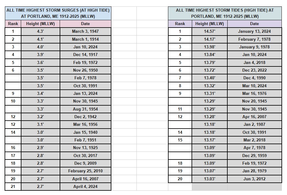
Here something a little different for general FYI. I got this table of highest storm surges and storm tides for Portland ME (PWM). I learned a few things here. Storm surge and storm tide are 2 different things, but we often use them interchangeably. Storm surge is the water height deviation from atmospheric phenomena in itself, nothing else. Storm tide takes into account everything, the atmospheric contribution, monthly astro tides, the 19 year tidal epoch, coast rise/drop, and anything else that may influence a tide height. In the NEUS/Mid-Atlantic we use storm tide the most b/c we have 2 high tides a day and our tidal ranges are high. Along the Gulf Coast, storm surge used most often b/c there is only 1 high tide a day and the tidal range is low. For PWM, 3 of the 5 highest storm surges are not even in the top 20 highest storm tides, so that shows how one is not necessarily related to the other. For proper historical scaling and an objective meteorological POV, storm surge is what one would use b/c that has only one factor. For storm tides, one may note that we've had 5 top ten tides in the last 8 years. But that is not a level playing field. PWM sea level has risen about 8" in 100 years, and more than half of that is due to local land subsidence.
-
Looks like multiple days of 100s
-
NWS website down. EDIT: Came back up as soon as I posted this.
-
-
smokin and grillin with AB - my favorite cooking YT channel right now. Want some BBQ baked chicken? These came out okay for my first time and I will refine and modify the ingredients.
-
"Saturday 6/27" weather event is over so prob time to lock the thread?
-
yeah, there's a trend here to scale back the heat collapse. We'll have to see on that but ...the 00z Euro was extending matters and now this 12z GFS is definitely backed off the calving S out of eastern Canada look it was previously selling over next weekend.
-
On the barrier islands sure but just inland away from them made it to 100 during the heat last summer since we had an established WNW downslope flow. We’ll see if that holds this time but it might be very impressive near the coast where that offshore flow can maintain.