All Activity
- Past hour
-

2025-2026 ENSO
40/70 Benchmark replied to 40/70 Benchmark's topic in Weather Forecasting and Discussion
I promise...if we get beyond the next solar min and nothing has changed, then I will fully capitulate. I wish I could say the same for the other side if NYC sees 50". -
I think it is extremely difficult right now to have an idea of what influences La Nina will have. There has been a markedly big shift in the hemispheric regime during La Nina events over the past few decades. With La Nina you always at least had some degree of troughing in North America, whether that be into Canada that would extend into the northern latitudes of the U.S. or into the PAC NW...but this signal has been almost absent mins 2010-2011 and 2021-2022 basically since the 80's.
-
Who is this clown!? Of course he screws Loudon and HoCo.
-
2025-2026 ENSO
40/70 Benchmark replied to 40/70 Benchmark's topic in Weather Forecasting and Discussion
I don't agree with this, but it's no sense arguing because this topic is so politicized....no one is ever going to change the other's mind. My guess if that even if it happens, the debate will still wage on because it will get worked into the narrative some how...."Well, we are fortunate we had a mismatch, which I saw comeing when the October MJO spiked...but it won't happen again". Long story short...it's like politics. No one is ever going to change their mind or admit that they are wrong...and around, around we will go- -
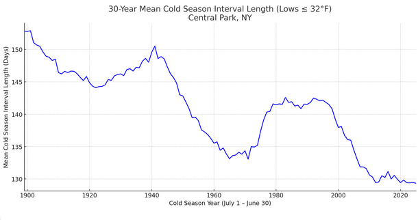
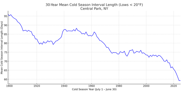
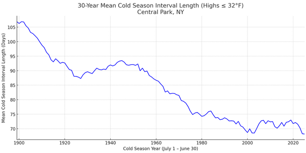
Yes, the cold season is being compressed. Lows of 32° or below: Lows < 20°: Highs of 32° or below:
-
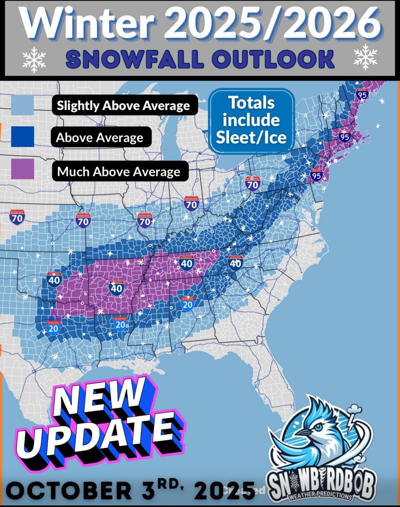
at least 50 inches in oakland MD.
-
A moderate RONI implies a pattern that appears to be correalting to a degree comensurate with said strength...regardless of whether or not the La Nina is coupled. All I care about in a seasonal outlook. The RONI doesn't measure the how well La Nina is coupled...MEI does that.
-

Spooky Season (October Disco Thread)
Typhoon Tip replied to Prismshine Productions's topic in New England
If by minor changes we mean upslope snow occurrences over a couple ... three different flat windy CAA intervals, with an in between season's first synoptic snow possibility - verification notwithstanding - before Halloween? sure -
Quickly yo 67
-
Why do you say that? Since I am only pointing out what the current climate is capable of producing. Absent a major volcanic event, it’s statistically unlikely for NYC to see a 50” season with how much the winters and the storm tracks have warmed.
-
This type of wx is possible up my way this time of year. We shall see.
-
Easiest winter forecast ever? Lol
-
Some scattered shwrs/stms blossomed around my area last night. 0.20" from that. Looks like the lawn will have to be mowed one last time.
-
2019 could be tough to beat for a while but JFK set their all-time November high last year at 82°. Time Series Summary for JFK INTERNATIONAL AIRPORT, NY - Month of Nov max high temperature Click column heading to sort ascending, click again to sort descending. 1 2024 82 0 2 2022 80 0 - 1950 80 1 3 1993 77 0 - 1982 77 0 - 1975 77 0 4 1974 76 0
-
Ha I like that, it helps me calibrate my station and make sure it's sited properly.
-
wow it happened 2 years ago, otherwise it's very rare. Think they can beat that 92 from 2023 Chris?
-
Think we will beat this October record within our lifetimes Chris? Records:Highs:EWR: 96 (2019)NYC: 93 (2019)LGA: 95 (2019)JFK: 95 (2019)
-
Records:Highs:EWR: 96 (2019)NYC: 93 (2019)LGA: 95 (2019)JFK: 95 (2019) wow a clean sweep in 2019 yesterday !!! NYC as always fell short of the mid 90s when everyone else hit 95 or higher lol. Lows: EWR: 39 (1997) NYC: 39 *1886) LGA: 42 (2003) JFK: 43 (2009) interesting about the cold weather in 2003 while Alaska had this: 2003: Alaska: Temperatures around 70 °F in many Alaska communities set many all-time October maximum records by as much as 17 °F. In Chalkytsik, the high of 75 °F broke the old record by 16 F degrees. Other daily record highs included: Fort Yukon: 70°, Fairbanks: 70°, Homer: 60° and Bettles: 57 °F. (Ref. WxDoctor) 1858 A hurricane with category 1 winds hit San Diego, CA, the only documented hurricane to strike California in history. This occurred before official weather observations began. Winds of at least 75 mph were estimated based on damage and journalistic accounts. Extensive wind damage to property neared F2 tornado scale damage. Streets were swept clean by heavy rains. (Ref. Wilson Wx. History) and this historic hurricane!
-
February is also warming quite quickly. January is the only real winter month.
-
Saw an all black wolly bugger while installing a flood sensor on Sligo Creek last Friday. Looks like mixing in NOVA and all snow in Maryland.
-
They also maintain snowcover for the whole season, like in the Poconos.
-
But it’s still very rare for MSP to hit 90° in October since it has only happened three times before. Time Series Summary for Minneapolis-St Paul Area, MN (ThreadEx) - Month of Oct Click column heading to sort ascending, click again to sort descending. 1 2023 92 0 2 1997 90 0 - 1928 90 0 4 1953 89 0 - 1922 89 0 6 2011 88 0 - 1947 88 0
-
Incidentally, if you want to know what REAL hot weather is like 10/2/2019, I remember it like it was yesterday (yesterday was actually the 6 year anniversary), 96 degrees with a heat index of 100 ! NOW THAT'S REAL HEAT
-
Low of 38 again at home, low of 68 here in Grapevine, TX
-
What does 'RONI will be moderate', mean. RONI is inherently an ONI minus a spatial limitation because the ENSO band is being increasingly isolated by the HC expansion, but also just because the oceanic basins are blazin' away anyway - it's really all fucked up. So a "moderate" RONI implies a decent amount of muting effect? I guess. If we really understand what that means both conceptually and wrt the practical mechanics, the ENSO scalar numbers may rise and fall below a wider and wider gap of threshold/boundary. In other (hypothetical example range) words, we'd going need to observe an ENSO sigma be > +1.5, or < -1.5, to really correlate to the general circulation modes of the mid latitude. Otherwise, it only looks at times like it is correlating, but interceding random variances then break correlation, which denies the assumption of a truly coupled state. My own present intuitive feel for this ( ...seeing as that's worth so much shit, lol ) is that we are not going to see an ENSO breach whatever the lower bound is. That said, the non-warm ENSO is a kind of false La Nina, where the winds behave like a cold phase but it's not really in that mode - good luck parsing out how much in either case. Isn't CC so much fun