All Activity
- Past hour
-

Tropical Storm Erin - 45 mph - W @ 20
40/70 Benchmark replied to BarryStantonGBP's topic in Tropical Headquarters
One thing I have learned is to always assume a harder recurve with respect to systems paralleling the coast, UNLESS there is a patently obvious reason not to, such as vigorous ULL absorbing the system....which are exceptionally rare occurences. This is why major NE strikes are so exceedingly rare. -
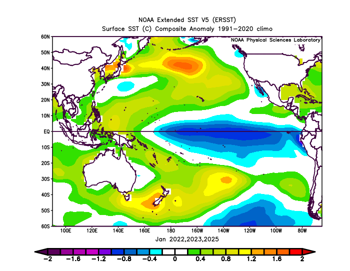
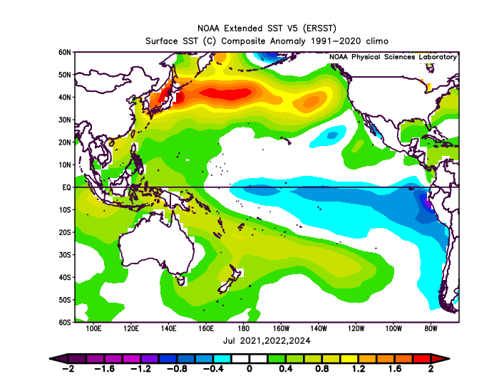
I think what we have been seeing from that record warm pool east of Japan in the 2020s is a seasonal shift from the summer into the fall and winter. The SST anomalies have been peaking there during the summers. Then declining as we have moved into the winter. Notice how the -PDO readings have also been following this pattern. The summer into fall 2021, 2022, and 2024 displayed a similar process. The lowest -PDO readings have occurred in the summer and fall and have risen into the winter. So the 21-22, 22-23, and 24-25 winters were all rising PDO patterns off the strongly negative values of the summer and fall. The main theme is that this seasonal pattern has kept repeating. So the winter values can’t get high enough to reverse the PDO when it starts declining again into the summers. The SSTs are marker for the 500mb ridging which keeps returning to the same areas. So even when we had a weaker trough east of Japan last winter, the SSTs couldn’t fully cool down. This could be related to the deep subsurface warmth there. Then there could be a feedback process between the atmosphere and SSTs perpetuating the 500mb pattern and extended record SSTs and -PDOs.
-
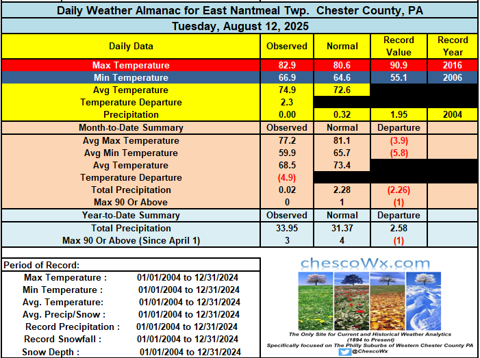
Showers and thunderstorms are becoming more likely as we move toward later this afternoon and into the night. For most spots this will be our first measurable rain since August 1st. The sun returns by Friday with above normal temperatures through the weekend and then cool back to near to below normal by early in the new work week. Our best chance at what could very well be our last 90 plus day of the summer looks to be Sunday.
-

E PA/NJ/DE Summer 2025 Obs/Discussion
ChescoWx replied to Hurricane Agnes's topic in Philadelphia Region
Showers and thunderstorms are becoming more likely as we move toward later this afternoon and into the night. For most spots this will be our first measurable rain since August 1st. The sun returns by Friday with above normal temperatures through the weekend and then cool back to near to below normal by early in the new work week. Our best chance at what could very well be our last 90 plus day of the summer looks to be Sunday.
-
There is nothing normal about this, it's actually pissing me off that it's over 100 degrees on Prince Edward Island, while we are stuck in mediocre low level *heat*
-
 it's actually pissing me off that they stole our heat!!!
 -

Tropical Storm Erin - 45 mph - W @ 20
BarryStantonGBP replied to BarryStantonGBP's topic in Tropical Headquarters
So Ed was a nothingburger Got it -
He's been busy chasing nonexistent hurricanes. Fitchburg has been cooking however.
-
2025-2026 ENSO
40/70 Benchmark replied to 40/70 Benchmark's topic in Weather Forecasting and Discussion
Yes. -
Tropical Storm Erin - 45 mph - W @ 20
40/70 Benchmark replied to BarryStantonGBP's topic in Tropical Headquarters
Noone was, unless you lived in a vessel ouside of the BM. I have lived in NE my entire life, though. I remember all of the hype for what ended up being yet another wide-right. -

E PA/NJ/DE Summer 2025 Obs/Discussion
JTA66 replied to Hurricane Agnes's topic in Philadelphia Region
Hit 91F yesterday. Forecast highs today and tomorrow are 88F and 85F. Unless something changes, no heatwave IMBY this week. -
Prince Edward Island at over 100 degrees really vexes me, there is no way PEI should be hotter than LI Thats the equivalent of Miami getting snow while it's raining up here!!
-
Tropical Storm Erin - 45 mph - W @ 20
BarryStantonGBP replied to BarryStantonGBP's topic in Tropical Headquarters
Were you in ed -
Tropical Storm Erin - 45 mph - W @ 20
BarryStantonGBP replied to BarryStantonGBP's topic in Tropical Headquarters

-
it probably depends on how August pans out but June 20 - July 31st was nicely hot. I would have liked to have hit 100 in July though.
-
The interesting thing is even Boston had onshore flow, the heat was pushed well to the north of us. What causes that to happen vs the more normal kind of heat we had in late June? In late June weren't the 100 degree temperatures more extensive (we were over 100 and so was Maine?)
-
$1500
-
No one here said it will maintain severely negative levels. But is a solidly -PDO winter a very good bet? Absolutely
-
Something interesting I've noticed is that our best winters come after our hottest summers. Cases in point: 1933-34, 1955-56, 1966-67, 1977-78, 1993-94, 1995-96, 2010-11
-

Summer 2025 Medium/Long Range Discussion
madwx replied to Chicago Storm's topic in Lakes/Ohio Valley
for those looking for cooler, less humid weather, seeing some potential in 10 days or so. But before then a ridge noses in and we get some more ring of fire action -
sheesh. what's your bill? we get screwed up here. $0.136/kwh for delivery (thanks cmp) and $0.106/kwh for supply.
-
How is the heat skipping here and getting up there-- look at that place Maple Plains right on the Ocean, it's over 100 degrees.
-
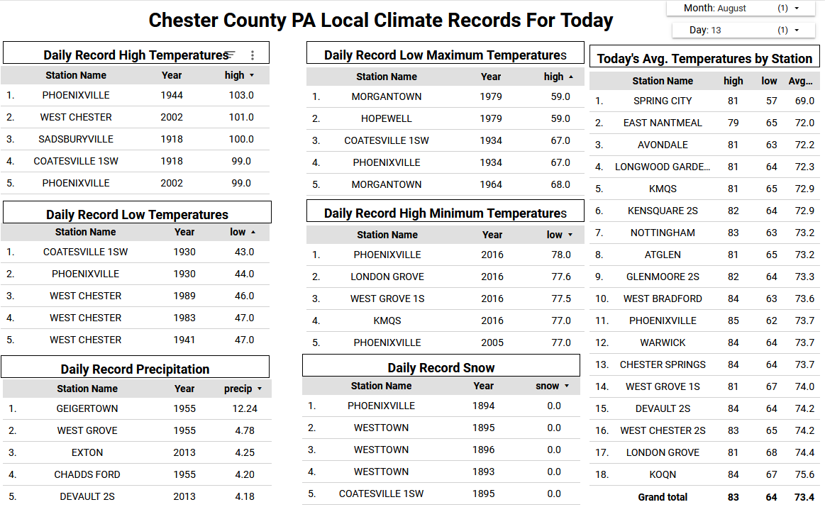
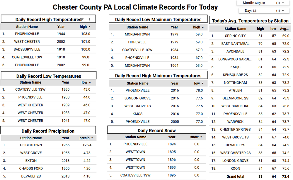
2014 - An official, New York State 24 hour precipitation record was set at Islip, NY on August 12-13 when 13.57" of rain fell.2014: In the New York City metro area early (Wednesday August 13, 2014) more than a foot of rain fell in just a few hours, causing extensive flooding on Long Island. As of 10 a.m. ET, Islip, New York had received 13.27 inches of rain, which set a state record for the heaviest 24-hour rainfall total in state history. This broke the previous record of 11.6 inches, set at Tannersville, New York in August of 2011 during Hurricane Irene. NY state record for the heaviest 24-hour rainfall(Ref.BY ANDREW FREEDMAN)Midwest and Mid-Atlantic Flooding: August 11-13. Five inches of rain in 24 hours inundated Detroit, Michigan, submerging cars up to their roofs, in one of the city's worst flooding episodes on record. Flooding also hit the Baltimore, Maryland, and Washington, D.C., areas, and Islip, Long Island, New York, measured 13.26 inches in 24 hours, setting a new state record. Economic costs exceeded $2 billion.Ref. (Weatherwise MAY-JUNE 2015, page 14) I remember this epic event as if it was yesterday!!!! 1995: Chicago, IL was in the midst of a four day heat wave where temperatures climbed into the middle 90s and lows were in the mid to upper 70s. The low temperature of 77° on this date tied for the record high minimum. Humidity was high and 27 deaths were attributed to the heat wave. The majority was in the Chicago area. (Ref. Wilson Wx. History) This was Chicago's endless summer 1980 - The afternoon high at New York City was just 89 degrees. But there were fifteen days of 90 degree heat during the month, their hottest August of record. (The Weather Channel) Wild, and this August 1980 record still stands-- it was hotter than most Julys!!
-
 78/ 74 hazy partly cloudy here.
 -
We used 2400kwh lol. Looks like our two central AC units are shot so we’ll need to replace them with heat pumps in the spring.