All Activity
- Past hour
-

Septorcher 2026 Discussion - Endless Summer
weatherwiz replied to Damage In Tolland's topic in New England
Agreed with that. But to be clear (though this may not matter) I was referring to H5 in general (across CONUS) - not just the specific feature. But I get what you're saying. -

2026-2027 Record-breaking El Nino
George001 replied to Stormchaserchuck1's topic in Weather Forecasting and Discussion
This El Niño is absolutely a beast, on track to be the strongest on record. However, I am extremely skeptical of El Niño conditions lingering into next June. If it were a weak El Niño I would be more inclined to buy the 2nd year Nino idea, but I would think it’s much more likely it collapses into La Niña rather than going from a super to moderate-strong El Niño. -

Septorcher 2026 Discussion - Endless Summer
Typhoon Tip replied to Damage In Tolland's topic in New England
It's not really noise though if one can identify the cause of the differences... Not meaning to be priggish ...just that it seems pretty clear - to me - that if the smear cross Cuba and gets pulled in en masse like the Euro, it's getting a huge physical feedback from that. I think Scott mentioned feedback yesterday - no arg there but 16 dm of?! "Noise" seems like a spray of offsetting probabilities... Well, this explains where. The GFS is less proficient with that infusion... The Euro, more. Results follow - But I agree, higher resolution is worth wondering - -
have to agree with you there - no way are boardwalks going to be ripped up and piers with roller coasters going to collapse into the Atlantic.
-

Septorcher 2026 Discussion - Endless Summer
TauntonBlizzard2013 replied to Damage In Tolland's topic in New England
This will be close to reality IMO. Hope it’s wrong because we desperately need the rain, but sell -

Septorcher 2026 Discussion - Endless Summer
Damage In Tolland replied to Damage In Tolland's topic in New England
Maybe in your area that doesn’t do wind well. But many windy areas are gonna roar for days and days. -
Septorcher 2026 Discussion - Endless Summer
Typhoon Tip replied to Damage In Tolland's topic in New England
Makes sense ... I was attempting to be in the water near the end of July up near Rye Beach/NH coast, and the 57ness of it was too much for the balls to handle... Couldn't really go in deeper than knees. 3 years ago around that same time I was there, and the 73 F water was warm enough that we were able to spend over an hour on boogie boards with no wet suits... Granted, this was an excessive warm anomaly for that area. Now, this is just one bloke's take on it, but I do check the summer progression of SST around here as a matter of course. And world over for that matter. As an ongoing observation I was never very impressed with the buoy numbers this summer. Seemed this was a regression year for local SSTs ... whether normal or not, notwithstanding. Just less in the way of residual heat to keep things elevated into autumn? -
That's just irresponsible. Yes, the storm is going to retrograde (unless all the models are wrong) but bad as Sandy is dumb.
-
They do weather bets
-
Yeah. $5 says the EURO is right. You put $5 to bet the GFS. WinterWarlock puts in $5.... we all put in $5.
-
101.1 was mentioning how this upcoming noreaster might be as bad as Sandy. Not even close.
-
Kashi a weather model ?
-

Septorcher 2026 Discussion - Endless Summer
WinterWolf replied to Damage In Tolland's topic in New England
I’d go 25-40 mph inland at the moment. If this thing wraps more over the next couple days…then we up the ante. Stay conservative for time being. -
Septorcher 2026 Discussion - Endless Summer
weatherwiz replied to Damage In Tolland's topic in New England
This is where you have to wonder whether the Euro's parameterization scheme just remains far superior to the GFS. I mean compare H5 of the Euro to the GFS from the 0z run at initialization. Now one could argue it's "noise" or subtle differences but IMO those differences for an initialization are rather large. I would also re-suggest the argument of the lack of upper-air observations within the region the s/w is traversing but the counter-argument to that would be - why is that not impacting the Euro...perhaps an answer to that would be...the euro is just more superior with initializing processes haha. Anyways, this post comes across as Euro is right and GFS is wrong - obviously we don't know that but lets say the Euro ends up scoring the scoop on this and blows the GFS away...may as well just put the GFS away. -
We need to create a bet on Kashi for this.
-

2026 Atlantic Hurricane Season
Windspeed replied to Stormchaserchuck1's topic in Tropical Headquarters
Regardless of the inadequacies of insurance policy, Sandy transitioned prior to landfall, and this was even confirmed in post-analysis. The mets at the NHC aren't going to get involved in politics, and they do not undermine their scientific work for the benefit of the private sector despite any conspiracies to the contrary. Granted, you didn't present this as your own opinion, but that of some others, but let us squash that discussion before it begins. -
did you expect yesterday to be partly sunny and mild a couple days out ? Saturday is still 4 days away - that HP in southeast Canada will control where the storm goes and I don't see it weakening to let the offshore storm backup towards the coast
-

E PA/NJ/DE Autumn 2026 Obs/Discussion
The Iceman replied to PhiEaglesfan712's topic in Philadelphia Region
.4” overnight/this morning 5.5” for September -
That's not even the GooFuS AI. I trust the baseline model GFS like I trust my dog not to eat a ribeye sitting in front of it for 5 minutes.
-
clearing as HP is moving in -
-
06z EURO holds serve. Retrograde around Riverhead and takes the LIE to NYC. Every weather model has the storm retrograding... it's just where. The less accurate models have it OTS and then hitting Nova Scotia, the GFS has it doing a circle around Boston and the Euro takes it on the Grand Central to NYC.
-

Septorcher 2026 Discussion - Endless Summer
CoastalWx replied to Damage In Tolland's topic in New England
SSTs are 61-63 offshore. Already cooling. -
Zero chance of being "clear."
-
Septorcher 2026 Discussion - Endless Summer
Typhoon Tip replied to Damage In Tolland's topic in New England
There's some sensitivity to deterministic solutions coming from the amount of positive vorticity ( how much?) getting pulled out of the Caribbean and injected between 42 and 90+ hours or so. This window of interaction is being slightly differently handled in the Euro vs GFS. The Euro is sweaty love-making. The GFS isn't sure what its feelings are ..heh Recent Euro runs are quite proficient/bullish with the result, because it is massively infusing this junk/failed zygote tropical entity into the agglomeration of weak S/W aspect that is wobbling through that lat/lon of the MA by the end of that time range. This transition of annotated charts over the course shows what happens when even weak N stream gets injected with a pithy diabatic heat source... The GFS is occasionally not as proficient with/in the integrating idea. The Euro has been rather persistent in forecasting a proficient phase at a range when modeling et al typically has higher average error when handling delicate matters. I took a look at the ensemble means of both ... it appears the idea of vestigial tropical infusion and subsequent unusual feedback due to that source is what I was personally missing yesterday in my analysis at that time. That does not mean it will happen like the Euro, per se... the 00z GGEM was less, as was the 06 GFS... We'll pick and choose ( ha, I can imagine which this particular group will pick!). But there's enough support from the orbit of the ens means of both camps to suggest a Euro idea isn't impossible. It is, however, one of the stronger members out of the whole EPS cluster, whereas the GFS is in the apparent interquartile mean of its own group. This is why suggest the scenario is a bit touchy. Smaller percentages less of the lower latitude diabatic source-inclusion into the holistic set up... will probably manifest something more like the a flatter/weaker less entertaining surface result. For now ..I'm willing to go less than the Euro's bigger dawg with this thing, but give it a nod should we get into a better deterministic range and the other models start getting more proficient/synergistic like that.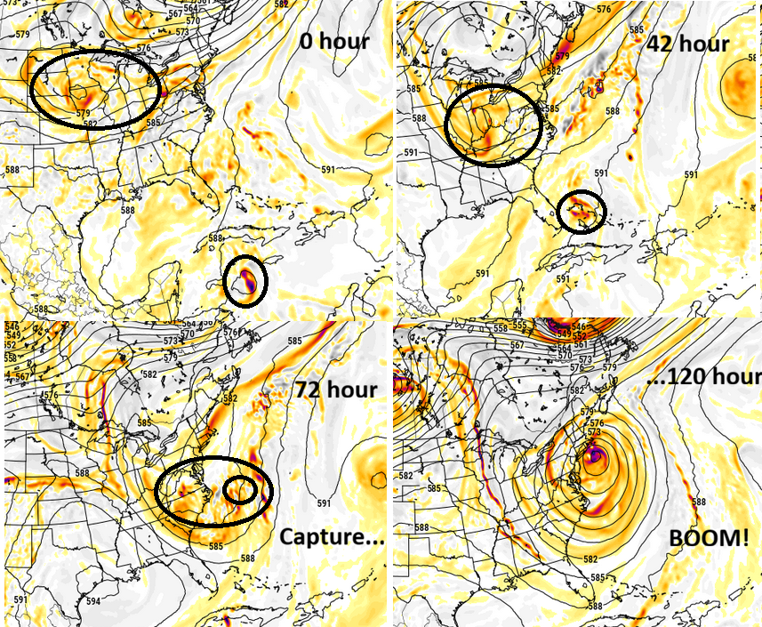
-

2026-2027 Record-breaking El Nino
GaWx replied to Stormchaserchuck1's topic in Weather Forecasting and Discussion
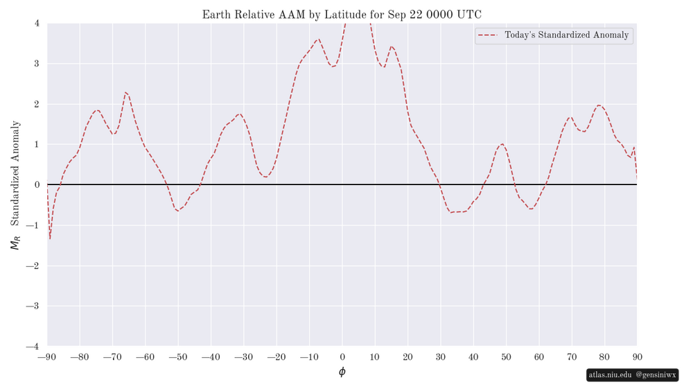
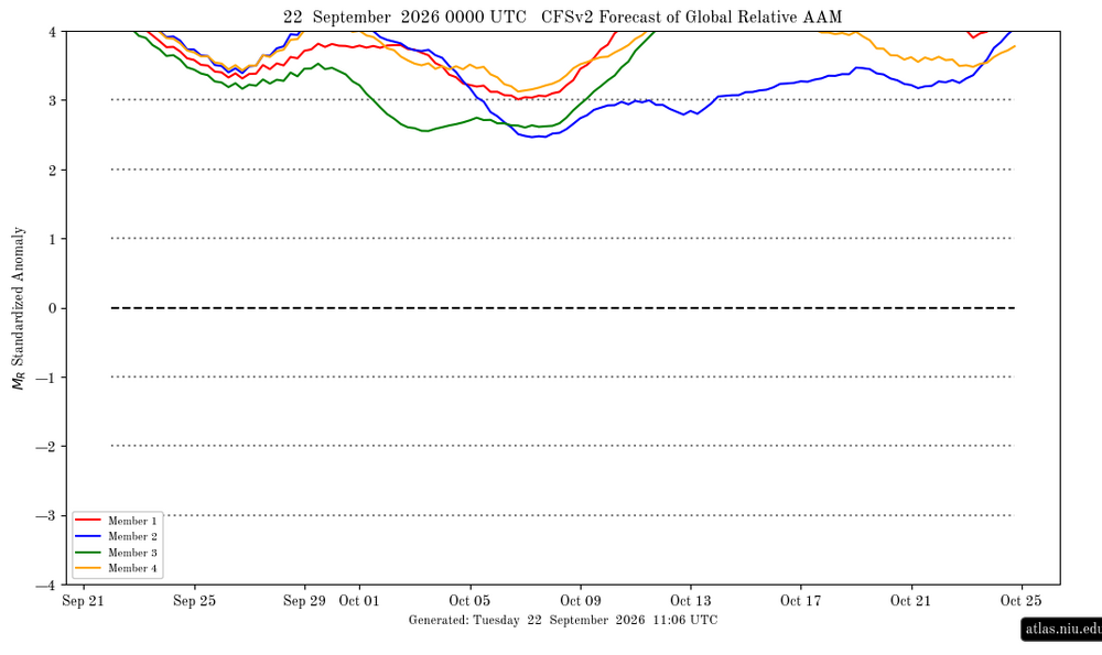
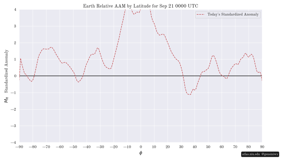
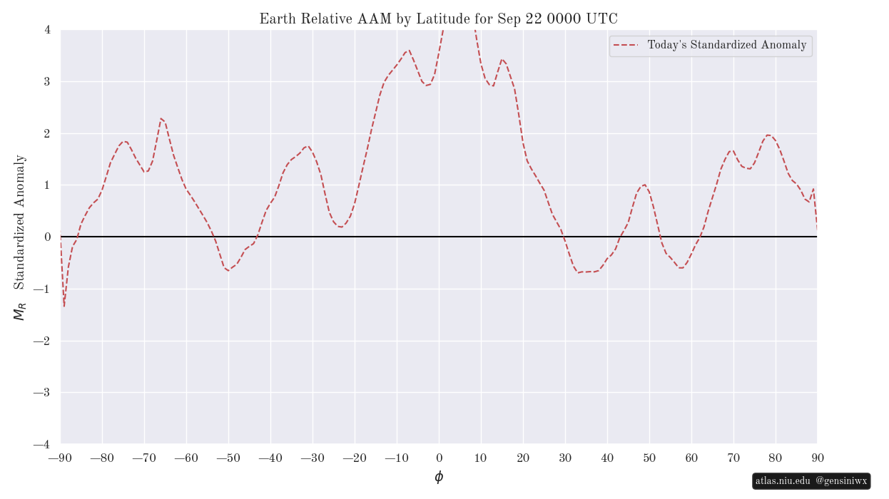
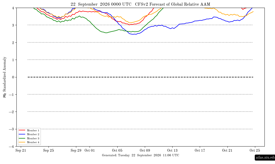
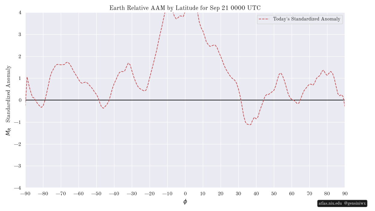
Thanks, Ray. Indeed, that 9/21/26 graph has the only significant pocket of -AAM centered at our latitudes as you noted. However, I assume you realize that these lat. based graphs are quite fluid, and thus it could look quite different at our latitudes within just a few days for all anyone knows. Also, the extremely + tropical latitudes overall have little choice but to drop back at least some soon. I’ll try to follow these daily from this point on. Here’s the brand new update for 0Z on 9/22/26: note that the -AAM pocket at our latitudes is still there and still the most significant -AAM area but isn’t as negative. Also, although 52N-61N has dropped, 63N to 90N is significantly more positive vs yesterday with a peak of +2 SDs at 78N vs +1.3 yesterday: Compare to yesterday’s: The corresponding global mean for 9/22/26 is as expected per prior days’ CFSv2 progs on its last legs of the extreme level of +4+ although it fwiw keeps a very strong +3+ mean on all but a few days in early Oct: