All Activity
- Past hour
-
Great stats Don, thanks
-
I don't believe today's light rainfall (0.10" at NYC, 0.08" at LGA and JFK, and 0.06" at Newark) will have much impact on Tuesday's high temperatures. Looking back at Central Park's long record, there were 6 100° days two days after measurable precipitation. In fact, on July 20, 1977, 0.06" rain fell. July 21, 1977 saw the mercury hit 104°. The most precipitation that fell two days before a 100° high was 0.36"; the most precipitation that fell one day before a 100° high was 0.16". The highest temperature two days after 1" or more rain was 99°; the highest temperature one day after 1" or more rain was 97°. The highest temperature two days after 2" or more rain was 95°; the highest temperature one day after 1" or more rain was 93°. Both those cases followed 3" or above rainfall. The highest temperature two days after 4" or more rain was 89°; the highest temperature one day after 4" or more rain was 87°. In short, heavier rainfall would have an impact. The light rainfall that occurred today shouldn't have much impact. The development of a sea breeze, cloud cover, and/or humidity will have a larger impact.
-
The humidity is really going to be a monster to overcome this week. Today was the "cooler" day of the heat wave and it was downright NASTY out this afternoon. 94/75 for the hi/low in my neighborhood. The dew point was able to breach 80 today in the middle of the afternoon with a majority of the time hovering around 77-79. Brutal
-
Stifling out. 87 dew 74.
-
Anybody just hear that? wasn’t lightning
-
Hope we see some triple digits at key sites. This will be high-end heat and humidity for another couple days regardless of if it hits 100F or not. 95-99F with high dews is uncomfortable enough.
-
10PM EWR: 87 LGA: 87 NYC: 85 JFK: 85 New Brnswck: 82
-
Yep, I only wear shorts working when it's an absolute necessity.
-
 weatherjp joined the community
 -
He's fine. Nature has a way of adapting.

-
So dumb
-
Not sure why anyone thinks rain on Sunday impacts our highs in Tuesday. A theory floated by some experienced posters as well. Bizarre
-
Yeah , it looks so cold at the end of the week you almost wonder if it's worth it?
-
Someone should go check on Wolfie..
.thumb.png.9ce209dd76f4d95c6557ac072f8eef41.png)
-
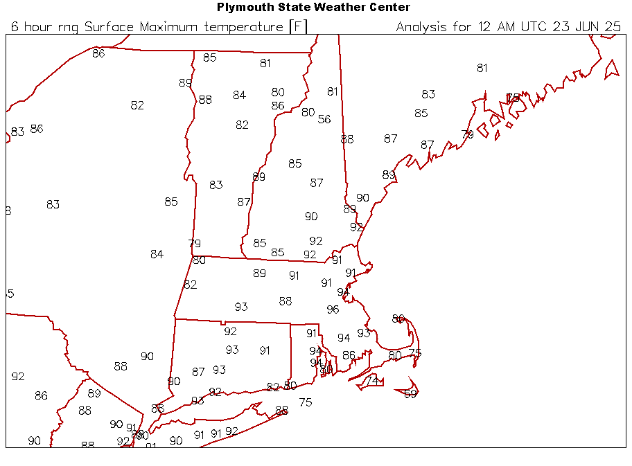
 For reference for tomorrow:
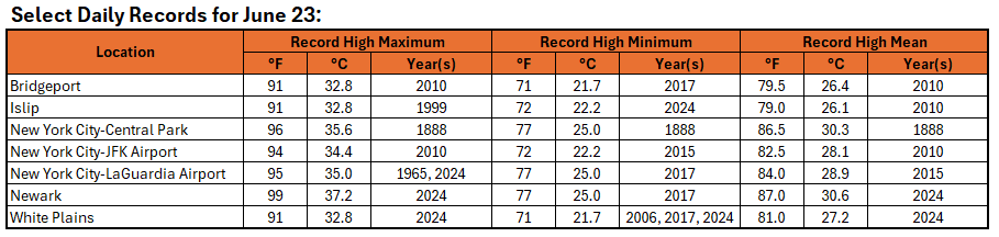
-
Todays highs.
-
 9pm CP 85. Heat index 91 EWR 88. Heat index 95
 -
9pm CP 85. Heat index 91 EWR 88. Heat index 95
-
I’m getting 1995 nostalgia with the breezy solstice sunsets and 100° days. Edit…of course last year was similar at the solstice too.
- Today
-
9:30 p.m. and holding at 80 degrees here. Very muggy evening with no breeze at all.
-
Similar ridge position and forecasted 850 MB temps (100s) Park of course missed , especially having come out of a very wet June 2013 7/18: EWR: 101 LGA: 100 JFK: 100 NYC: 98 7/19: EWR: 100 LGA: 100 NYC: 96 JFK: 95
-
9:30 p.m. and holding at 80 degrees here. Very muggy evening with no breeze at all.
-
Winds were more northerly than expected. For this reason islip and westhampton were in the low 90s and the north shore cooler. Wasn’t hot at all in Lloyd Harbor today.
-
Forecast low of 68 but I am already down to 75 off my high of 87.4
-
67 in Montauk and 107 in the city. k


.png.56852ed3179ff5b0785423b44d81e6b1.png)


