
All Activity
- Past hour
-

Septorcher 2026 Discussion - Endless Summer
WinterWolf replied to Damage In Tolland's topic in New England
Really? Wow did not even know it existed. Although I haven’t been on here in months, so I’m behind the latest stuff. Thanks Scott. -

Septorcher 2026 Discussion - Endless Summer
CoastalWx replied to Damage In Tolland's topic in New England
Yeah, it’s been developed by Google. -
Hit 90 today. Hopefully the last one for the year but I doubt it.
-
Septorcher 2026 Discussion - Endless Summer
CoastalWx replied to Damage In Tolland's topic in New England
Yeah that model is outperforming everything else. -
Septorcher 2026 Discussion - Endless Summer
WinterWolf replied to Damage In Tolland's topic in New England
What is that? AI stuff? -
Seasonal models and even CPC long range forecasts gravitate towards average. And it doesn't really account for global warming. If the models has you in like +1.5f, expect their being right as really being +4
-
Septorcher 2026 Discussion - Endless Summer
WinterWolf replied to Damage In Tolland's topic in New England
Don, I said Jr., hence her little brother. Little being the key word. Not 2.0. -
Septorcher 2026 Discussion - Endless Summer
CoastalWx replied to Damage In Tolland's topic in New England
Weathernext deep mind has a ton turning west south of ACK to BID line. Even a few into NJ. -

Septorcher 2026 Discussion - Endless Summer
WxWatcher007 replied to Damage In Tolland's topic in New England
Nice shot! Burst mode is your friend. A video with a screen grab works nicely too. -

Septorcher 2026 Discussion - Endless Summer
SnoSki14 replied to Damage In Tolland's topic in New England
NJ up to southern CT have seen the bulk of the summer rains so you might be onto something Now would this be subtropical? -
Septorcher 2026 Discussion - Endless Summer
WxWatcher007 replied to Damage In Tolland's topic in New England
Sandy 2.0 is not walking through the door. Let’s ease up here lol. Euro is a good hit, though not especially wet. That said, don’t underestimate long duration winds with sig rain and astronomical high tides. This could be quite impactful with the right track. -
 http://axeryl.com/# prednisone buy
 -

Septorcher 2026 Discussion - Endless Summer
mreaves replied to Damage In Tolland's topic in New England
Decent storm offshore in the gulf. I tried to get some lightning pics but I don’t have the talent or equipment for that. I did get this shot with my basic iPhone.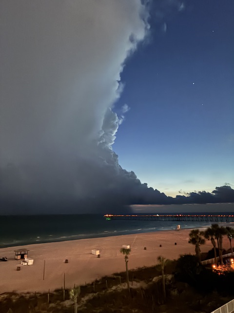
-
Nabers is back in. Dart could be done that looked bad
-
A big issue I see with the CFS is, with the Winter 500mb pattern being modeled over the N. Pacific, you aren't going to get that strong of an East Coast trough. Since 2016 the Pacific has held much more weight than the NAO. Then again as I already mentioned in this thread, sin 2024 and 2025 I saw runs of the CFS having -38F anomalies in the NW, US for the whole month of December! Can you believe they ended up well above average?
-
Another 90 degree day in the books at PTI!
-
secure medical online pharmacy or no prescription pharmacy paypal best online pharmacy no prescription https://www.klickerkids.de/index.php?url=http://belvionpharmacy.shop safe online pharmaciesor http://www.garmoniya.uglich.ru/user/wtyfxxayrd/ best mail order pharmacy [url=https://cse.google.com.bz/url?sa=t&url=https://belvionpharmacy.shop]online pharmacies[/url] secure medical online pharmacyor [url=https://4k-porn-video.com/user/gfwbvdtjxm/]secure medical online pharmacy[/url] online pharmacies
-
Septorcher 2026 Discussion - Endless Summer
WinterWolf replied to Damage In Tolland's topic in New England
Nope…we don’t. It’s been a weekend/Sunday thing all spring and summer…why not keep it going for the first Nor ‘Easter of the season. Let it rain some more. -
Wierd.. why would the NAO be negative all of a sudden? It hasn't been negative in 14 years, and this is the ripe +year time after Solar Max and strong +QBO.. not saying it's impossible but I think they are displacing the El Nino N. American ridge.
-

Septorcher 2026 Discussion - Endless Summer
Damage In Tolland replied to Damage In Tolland's topic in New England
This as of now is 40-60 interior and 50-70 coasts -
Ugh
-
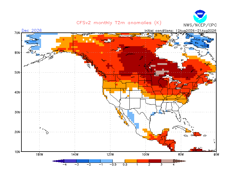
WB CFSv2 temp maps: 1. Have algo issues that lead to bad artifacts. I’ve posted on this here in the past. Here are some examples -note the cold spot over S Lake Michigan and warm spot only 250 miles to the north over N Lake Michigan that are almost always on these WB maps; the real CFSv2 output essentially never has these -note the E coast down to FL usually looks like a thin sharp warm barrier to any colder anomalies to the west; again, this essentially never is on the real output 2. WB CFSv2 maps are strongly cold biased for much of the E US. And this is the case even with WB using the colder 1981-2010 climo instead of 1991-2010, which the CFSv2 site uses! All one has to do to know this is to compare to the maps at the CFSv2 site. All 4 (DJFM) are notably too cold in almost all of the area away from the E coast. But I’ll focus on the Dec map to illustrate the strong cold bias: -Chicago’s +0.5C/1F vs 1981-2010 on WB but the CFS site’s relevant 10 day mean maps (see below) are all significantly warmer and they average +2.25C/4F vs the warmer 1991-2020 meaning WB is ~4F too cold. -SL’s 0.0 C/F vs 1981-2010 on WB but CFS actual maps are all significantly warmer and average +1.5C/3F vs 1991-2020 meaning WB is ~4F too cold -Knoxville’s -1C/-2F vs 1981-2010 on WB but CFS actual maps have it at +0.6C/+1F vs 1991-2020 meaning WB’s ~4F too cold -Despite the CFS site’s maps averaging AN from TN-NC north, WB in inland areas doesn’t have AN start til 500 miles to the N in N IL to N OH to NW PA and that’s even vs a colder climo base! That’s ignoring the immediate E coast, which has its own problems as already noted and is actually a bit too warm overall despite it being 4F too cold for much of the inland areas! Relevant 10 day mean Dec maps at CFSv2 site: 9/10-19: 8/31-9/9: 8/21-30: 8/12-21: @Stormchaserchuck1@donsutherland1
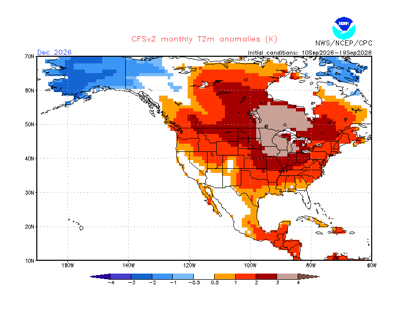
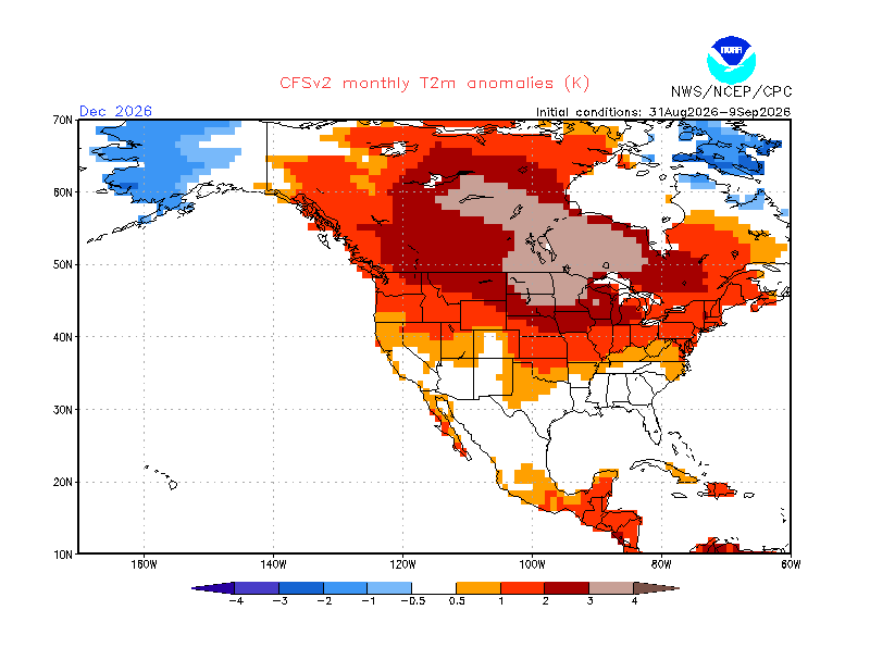
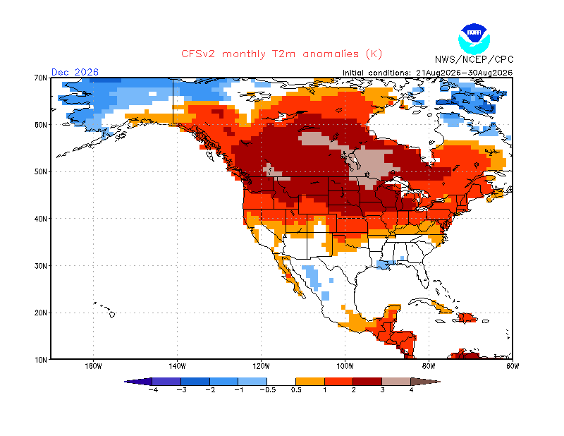
-
.thumb.gif.f92b16c631a1d15d405ed77b33f0710d.gif)
Septorcher 2026 Discussion - Endless Summer
Torch Tiger replied to Damage In Tolland's topic in New England
Don't get me wrong, I'm all for decimating east coastal areas and the beaches, houses falling into the angry ocean etc. but doesnt look particularly impactful for most -
If Dart and Nabers have significant injuries, the Giants season is over
-
Septorcher 2026 Discussion - Endless Summer
Torch Tiger replied to Damage In Tolland's topic in New England
you're expecting damage?













