All Activity
- Past hour
-

BAY OF CAMPECHE 98L NOW UP TO 20/20
BarryStantonGBP replied to BarryStantonGBP's topic in Tropical Headquarters
MATE 98L IS NOWHERE NEAR BERMUDA/CANADA -
 Yep, my a/c was turned back on at 11 AM and there isn't even any sun today. On Monday I didn't turn it on until 4 PM.
 -
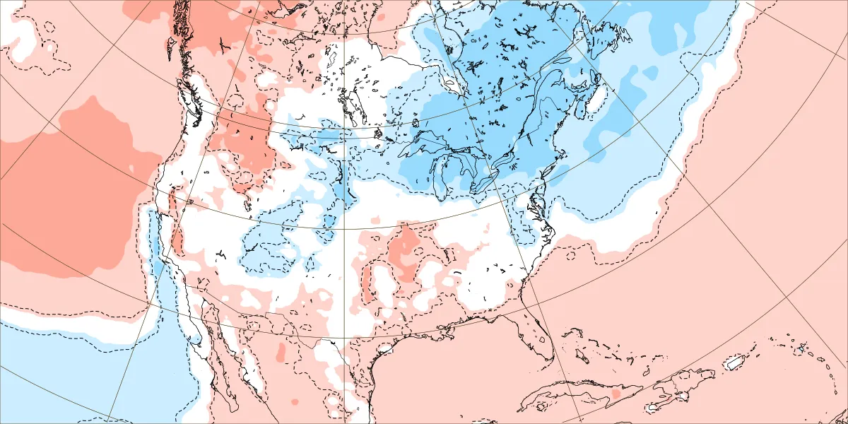
Nice to see this on the latest weeklies. Temps have been dropping for that period over the next few days.

-
 Feels much worse than the 90 on Monday
 -
not really lol
-
wow lots of historic heat in extremely hot summers on this date 1933: Bakersfield, CA reached 117° to set their all-time record for August. Hanford reached 115° for the second day in a row, tying their all-time August high temperature record. (Ref. Wilson Wx. History) 1936 - Temperatures across much of eastern Kansas soared above 110 degrees. Kansas City MO hit an all-time record high of 113 degrees. It was one of sixteen consecutive days of 100 degree heat for Kansas City. During that summer there were a record 53 days of 100 degree heat, and during the three summer months Kansas City received just 1.12 inches of rain. (The Kansas City Weather Almanac) 1980: National Airport had a 98° high temperature today the last of 21 consecutive days of 90°F or more. (Ref. Washington Weather Records - KDCA) The temperature reached the century mark for the 53rd time in Dallas, TX, establishing the all-time record for 100 degree plus days in a year. (Ref. AccWeather Weather History) 1988 - Eighteen cities in the northeastern U.S. reported record high temperatures for the date, and the water temperature at Lake Erie reached a record 80 degrees. Portland ME reported a record fourteen straight days of 80 degree weather. Milwaukee WI reported a record 34 days of 90 degree heat for the year. Afternoon and evening thunderstorms resulted in about fifty reports of severe weather in the northeastern U.S. One person was killed at Stockbridge MI when a tornado knocked a tree onto their camper. (The National Weather Summary) (Storm Data) 2002: A 594 decameter area of high pressure off the Carolina coast produced hot south to southwesterly winds ahead of a cold front bringing record heat to parts of the east. The temperature in Boston, MA reached 101°, equaling their August record (8/2/1975). Other daily records included: Syracuse, NY: 101°, Concord, NH: 99°, Hartford, CT: 99°, Allentown, PA: 99°, Philadelphia, PA: 99°, Milton, MA: 98°, Providence, RI: 98°, Rochester, NY: 97°, Harrisburg, PA: 97°, Burlington, VT: 96°, Binghamton, NY: 95° and Erie, PA: 94°. (Ref. Wilson Wx. History) In San Angelo, TX, just after midnight, a descending heat-burst jumped the temperature from 75° to 94° in 30 minutes. The event ended about 90 minutes later when the temperature fell back to 73°. (Ref. Wilson Wx. History) (Ref. WxDoctor) The tropics were very active in 1953 and we still managed to have a historic heatwave and triple digit temperatures right at the peak of hurricane season in September!!! 1953 - Hurricane Barbara hits North Carolina as a Category 2 hurricane. Damage from the storm was relatively minor, totaling around $1.3 million (1953 USD). Most of it occurred in North Carolina and Virginia from crop damage. The hurricane left several injuries, some traffic accidents, as well as seven fatalities in the eastern United States; at least two were due to electrocution from downed power lines. Offshore Atlantic Canada, a small boat sunk, killing its crew of two.
-
Who cares? This the the MA forum. There's a western US forum.
-
Weeklies have really been cooling down for near future.

-
2025 Atlantic Hurricane Season
BarryStantonGBP replied to BarryStantonGBP's topic in Tropical Headquarters

-
BAY OF CAMPECHE 98L NOW UP TO 20/20
BarryStantonGBP replied to BarryStantonGBP's topic in Tropical Headquarters
that's what I think too lad -
There was plenty of rain here even if not 1 inch Don, we rarely ever get 1 inch of rain from thunderstorms around here, they just do not last long enough. That said the 0.5-0.8 inch of rain was plenty.
-

BAY OF CAMPECHE 98L NOW UP TO 20/20
WxWatcher007 replied to BarryStantonGBP's topic in Tropical Headquarters
No, there's just not enough time for that kind of organization to occur imo. This is probably making landfall tomorrow afternoon which would suggest ~45kt intensification in 24 hours. That would require exceptionally fast organization just to allow for the kind of pressure falls necessary to bring winds up to 64kt. A "lower end" TS would be more likely. -
it's not like they get this right every time.
-
The skies were purple here just before sunset, that very rarely happens here. I thought I saw the beginnings of a rainbow too, but the rain came in and it got too dark for one to form, it was very pale regardless. It looked like a pink bow in a purple sky lol
-
New invest in the Gulf, with time as a limiting factor.
-
BAY OF CAMPECHE 98L NOW UP TO 20/20
BarryStantonGBP replied to BarryStantonGBP's topic in Tropical Headquarters
Do you think this little fella can reach C1 -
He doesn't have a clue.
-
Interesting - CTP disagree! Lol
-
2020 had that supercell that ripped across southwester/southern CT (think august 26th or 27th). Outside of some very localized damage it's been a bore since the 2018 event. Was it two summers ago (maybe three) where we had a decent stretch I think in July with storms...nothing crazy but it was active.
-
We had a good event two years ago late month. Of course I missed it, but we had wind damage here. Overall though I feel like it's been quiet.
-
BAY OF CAMPECHE 98L NOW UP TO 20/20
WxWatcher007 replied to BarryStantonGBP's topic in Tropical Headquarters
Although it's convectively active, it doesn't look particularly organized and time is a huge limiting factor. It's a low shear environment and the BoC so we'll see if that helps organize this faster into a TC. We'll know more should recon fly today at 18z. -
Yeah, that is my early guess based on past multiyear La Ninas since the late 90s. There is usually one year with a strong +PNA December mismatch. The other surrounding Decembers had either a weaker positive or a negative PNA. So I will go lower on the PNA for December 2025 than the +1.70 we had in December 2024. But not sure yet whether it’s just a weaker positive or the PNA dips negative. Multiyear La Ninas and December PNA 2025…….? 2024….+1.70 2022….-0.66 2021….-2.56 2020…+1.58 2017…..+0.89 2016….-0.35 2011….+0.36 2010….-1.78 2008….-1.41 2007…..+0.14 2000…..+1.23 1999…..+0.21 1998…..-0.09
-
BAY OF CAMPECHE 98L NOW UP TO 20/20
BarryStantonGBP replied to BarryStantonGBP's topic in Tropical Headquarters
OI LADS YOUS COULD GET A LASTMINUTE.COM CATEGORY 1 INTO TEXAS INNIT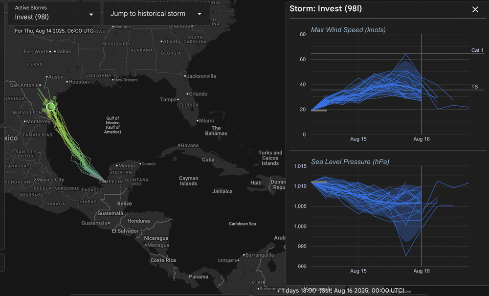
-
2025 Atlantic Hurricane Season
BarryStantonGBP replied to BarryStantonGBP's topic in Tropical Headquarters
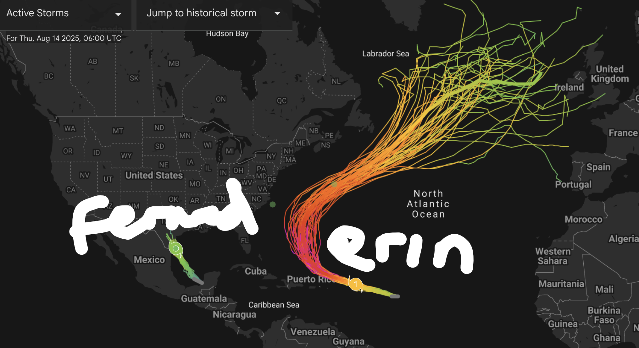
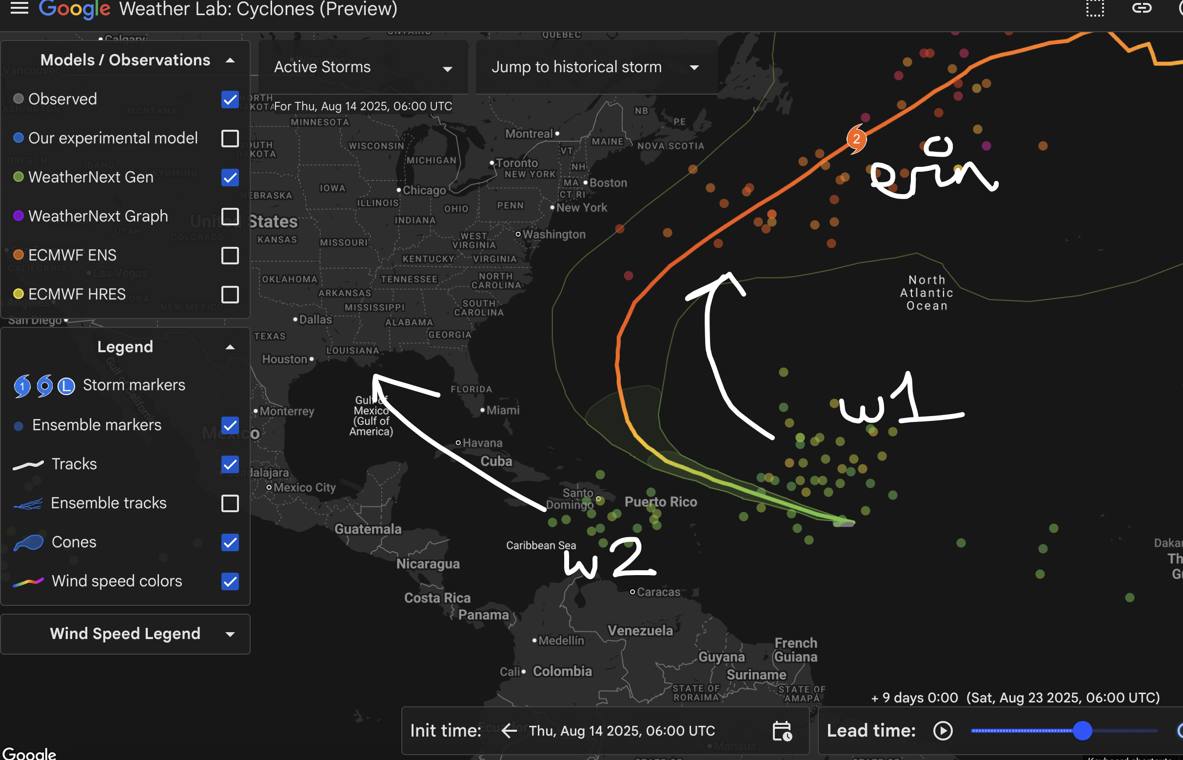
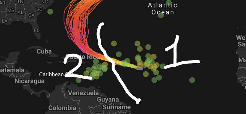
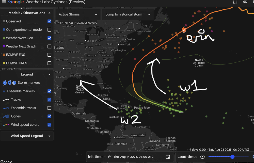
DEEPMINDS UPDATE: Erin expected to peak as a Cat 3-4, safe recurve for the CONUS but Bermuda needs to watch out "Fernand" remaining a weak TS into TX (98L) and could be a category 1 "Gabrielle" becoming an OTS CV recurver (major) "Humberto" forms in the WCAR and vomits in the Gulf (major landfall)
-
If it's not being watered consistently, it's dead around here