TellicoWx
-
Posts
2,632 -
Joined
-
Last visited
Content Type
Profiles
Blogs
Forums
American Weather
Media Demo
Store
Gallery
Everything posted by TellicoWx
-
January 15th-17th 2024 Arctic Blast/Snow Event
TellicoWx replied to John1122's topic in Tennessee Valley
If GFS is in the right ballpark, maybe a tad more than a backend fluff -
January 15th-17th 2024 Arctic Blast/Snow Event
TellicoWx replied to John1122's topic in Tennessee Valley
With this system being a little flatter, it may leave the gulf more open for #2 (or the wave may turn into a #2 lol) -
January 15th-17th 2024 Arctic Blast/Snow Event
TellicoWx replied to John1122's topic in Tennessee Valley
Flatter the system, the more the Hi-Res mods will carry more weight due to the complex features of the valley. -
January 15th-17th 2024 Arctic Blast/Snow Event
TellicoWx replied to John1122's topic in Tennessee Valley
Definitely flatter....western side ticked north. -
January 15th-17th 2024 Arctic Blast/Snow Event
TellicoWx replied to John1122's topic in Tennessee Valley
Think NWS offices are pulling the trigger quicker due to the Arctic air following the system. Giving an increased lead time to the public. Wouldn't be shocked to see MEG pull the trigger early depending on how rest of 12z wraps up. They have it built into their wording for up to 36 hr lead. -
January 15th-17th 2024 Arctic Blast/Snow Event
TellicoWx replied to John1122's topic in Tennessee Valley
12z ICON shift SE..models are consolidating -
January 15th-17th 2024 Arctic Blast/Snow Event
TellicoWx replied to John1122's topic in Tennessee Valley
Add that with rates slightly weaker and end up with drizzle here (freezing drizzle a lot of the time) -
January 15th-17th 2024 Arctic Blast/Snow Event
TellicoWx replied to John1122's topic in Tennessee Valley
12z HRRR...I know voodoo land for it lol -
January 15th-17th 2024 Arctic Blast/Snow Event
TellicoWx replied to John1122's topic in Tennessee Valley
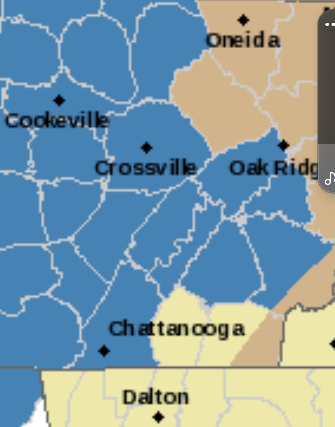
OHX: An upper level system to our west will then approach mid state region as Sunday night through Monday progresses, eventually pushing east of our area as day on Tuesday progresses. Lows on Sunday night will range in low to mid teens. Highs on Martin Luther King Jr Day will range mainly low to mid 20s. Lows Monday night will be in low to mid teens. Highs on Tuesday will actually be even colder than Martin Luther King JR Day, ranging upper teens northwest to lower 20s elsewhere. Models coming more into line with potential of an accumulating snowfall event across mid state region during Sunday night through Tuesday morning time frame. Best potential of accumulating snowfall will be as Martin Luther King Jr Day progresses. Because models trending toward a common depiction of snowfall and snowfall potential across our area, and in coordination with surrounding offices and WPC Winter Weather operations, have issued a winter storm watch for accumulating snowfall amounts ranging from around 3.0 inches up to 4.5 inches across mid state region during this time period. Some lingering snow showers may persist across Cumberland Plateau Region on Tuesday afternoon with flurry chances to its west, but no additional snowfall accumulations expected presently. -
January 15th-17th 2024 Arctic Blast/Snow Event
TellicoWx replied to John1122's topic in Tennessee Valley
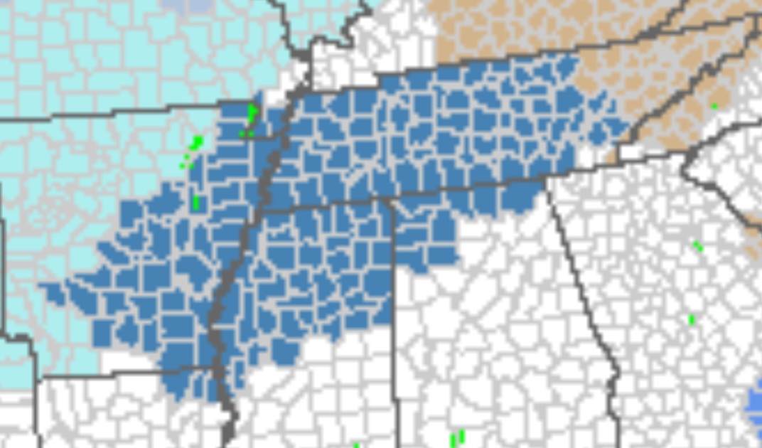
MRX disco: An upper 300mb jet streak strengthens to over 140 kt into Monday morning with broad upper-level divergence across the Tennessee Valley and Southern Appalachians. Lower-level flow will become convergent in response to this divergence and result in widespread isentropic lift with light to moderate precipitation on Monday across the region. Deterministic QPF amounts for Monday show a likely range of 0.2 to 0.5 inches across much of the area which is expected to fall as all snow across most of the area based on model forecast soundings. With these QPF amounts, at least 2 to 5 inches of snow appear likely across most of the forecast area and a Winter Storm Watch has been issued for these locations. The most uncertainty is across our far southeastern counties which will not have as much deep cold air in place. They may have some mixed precipitation which would limit overall snowfall totals. Therefore, confidence in snow totals for these counties is lower and they are not included in the watch at this time. The ECMWF/GFS/GDPS all show a band of 0.5 to 0.8 inch QPF, and depending on where this band sets up, some areas could see higher than currently forecast snow totals. Counties within the Winter Storm Watch all have at least a portion of the county above a 50% chance of 2 inches of snow. Portions of the valley and plateau have above 50% chances of seeing at least 4 inches of snow. A low pressure system will develop along the Gulf Coast and move northeast towards the Carolinas on Monday night into Tuesday. Depending on the track of this low, we may or may not see additional precipitation on Tuesday. At this time, we are less confident in snowfall amounts on Tuesday than on Monday, but expected additional QPF and snowfall appears minimal at this time, most likely 0.1 inch of QPF or less. This may add an additional inch or two of snow to mainly our far eastern counties near the mountains along the TN/NC state line. -
January 15th-17th 2024 Arctic Blast/Snow Event
TellicoWx replied to John1122's topic in Tennessee Valley
You couldn't add these two could ya MRX
-
January 15th-17th 2024 Arctic Blast/Snow Event
TellicoWx replied to John1122's topic in Tennessee Valley
WSW rolling out
-
January 15th-17th 2024 Arctic Blast/Snow Event
TellicoWx replied to John1122's topic in Tennessee Valley
Think it will be I-40 and north for the valley, all plateau/mountains. They will probably hold off on Southern valley unless there is some changes across all the models. -
January 15th-17th 2024 Arctic Blast/Snow Event
TellicoWx replied to John1122's topic in Tennessee Valley
Yeah once we hit 48 hrs I normally stop using them -
January 15th-17th 2024 Arctic Blast/Snow Event
TellicoWx replied to John1122's topic in Tennessee Valley
I think I'm cautiously optimistic here...only thing I haven't liked today was the GEFS has cut totals every run since 6z, but that could be more smoothing as we draw closer (or at least I hope so) -
January Medium-Long Range Discussion
TellicoWx replied to Holston_River_Rambler's topic in Tennessee Valley
Signal still there on 18z GFS...2 storm total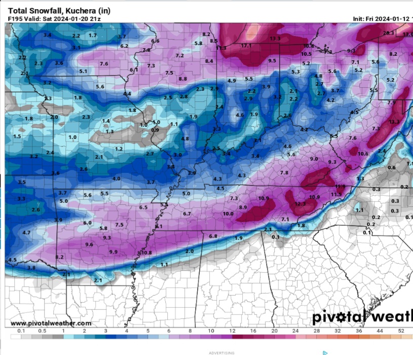
-
January 15th-17th 2024 Arctic Blast/Snow Event
TellicoWx replied to John1122's topic in Tennessee Valley
Finally got power back...surprised a little as well about Memphis pulling trigger, figured wouldn't be until tomorrow afternoon. Glad to see @nrgjeffposting. -
January 15th-17th 2024 Arctic Blast/Snow Event
TellicoWx replied to John1122's topic in Tennessee Valley
May not get to watch Euro run....trees going down left and right here, ands powers out -
January Medium-Long Range Discussion
TellicoWx replied to Holston_River_Rambler's topic in Tennessee Valley
GEFS still running, but TDOT is gonna need a plow strapped to the front of an M1 Abrams to clear the roads on some of these members -
January Medium-Long Range Discussion
TellicoWx replied to Holston_River_Rambler's topic in Tennessee Valley
Need to frame that on a wall lol -
January 15th-17th 2024 Arctic Blast/Snow Event
TellicoWx replied to John1122's topic in Tennessee Valley
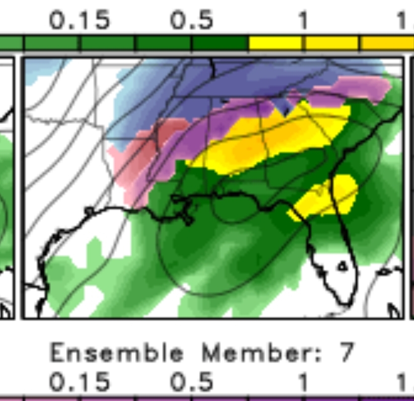
This is what amped up looks like...i present member 7 lol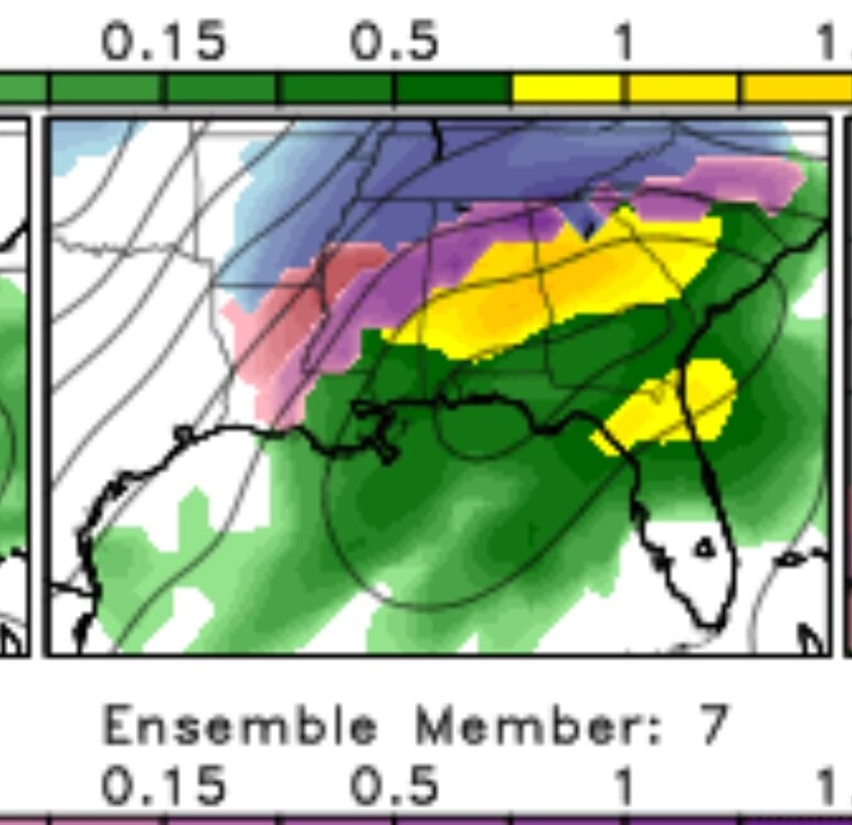
-
January 15th-17th 2024 Arctic Blast/Snow Event
TellicoWx replied to John1122's topic in Tennessee Valley
If you look at the GEFs, do not look at member 7...System that shall not be named has made an appearance lol -
January 15th-17th 2024 Arctic Blast/Snow Event
TellicoWx replied to John1122's topic in Tennessee Valley
12z GEFs with a lot of lows in the central/western gulf at 84 -
January 15th-17th 2024 Arctic Blast/Snow Event
TellicoWx replied to John1122's topic in Tennessee Valley
Cmc smokes the northern and Central valley -
January 15th-17th 2024 Arctic Blast/Snow Event
TellicoWx replied to John1122's topic in Tennessee Valley
Wait until they look at their Ole reliable 6z Dr No (aka NBM) lol