

TellicoWx
-
Posts
2,632 -
Joined
-
Last visited
Content Type
Profiles
Blogs
Forums
American Weather
Media Demo
Store
Gallery
Everything posted by TellicoWx
-
January 15th-17th 2024 Arctic Blast/Snow Event
TellicoWx replied to John1122's topic in Tennessee Valley
While Hi-Res is the way to go..globals painting swaths like the 6z ICON and GFS has done..I would not be surprised if a couple Hi Res don't go full bonkers in the next couple runs today. -
January 15th-17th 2024 Arctic Blast/Snow Event
TellicoWx replied to John1122's topic in Tennessee Valley
GFS about to unload on the valley -
January 15th-17th 2024 Arctic Blast/Snow Event
TellicoWx replied to John1122's topic in Tennessee Valley
Think it's more of an algorithm issue...some models struggle a little more than others with high terrain features as far as exact locations. Rockies are a prime example, resolution is almost non existent there. -
January 15th-17th 2024 Arctic Blast/Snow Event
TellicoWx replied to John1122's topic in Tennessee Valley
Looking at the 6z runs so far, think they are right. You can almost trace the spine of the Apps from WV thru TN with the accum maps. -
January 15th-17th 2024 Arctic Blast/Snow Event
TellicoWx replied to John1122's topic in Tennessee Valley
6z ICON upping totals -
January 15th-17th 2024 Arctic Blast/Snow Event
TellicoWx replied to John1122's topic in Tennessee Valley
6z RGEM joins the HRRR -
January 15th-17th 2024 Arctic Blast/Snow Event
TellicoWx replied to John1122's topic in Tennessee Valley
Looks like the NAM got the boot from NWS offices -
January 15th-17th 2024 Arctic Blast/Snow Event
TellicoWx replied to John1122's topic in Tennessee Valley
Hun: 2-5....OHX 3-6 -
January 15th-17th 2024 Arctic Blast/Snow Event
TellicoWx replied to John1122's topic in Tennessee Valley
MRX entire CWA warning...3-6, except Polk and Bledsoe 2-4 Edit...Hamilton 2-4 (some reason has its own message) -
January 15th-17th 2024 Arctic Blast/Snow Event
TellicoWx replied to John1122's topic in Tennessee Valley
MRX, OHX, HUN pull trigger..Warnings out -
January 15th-17th 2024 Arctic Blast/Snow Event
TellicoWx replied to John1122's topic in Tennessee Valley
FFC: URGENT - WINTER WEATHER MESSAGE National Weather Service Peachtree City GA 314 AM EST Sun Jan 14 2024 GAZ001>003-142000- /O.UPG.KFFC.WS.A.0001.240115T1200Z-240116T1200Z/ /O.NEW.KFFC.WS.W.0001.240115T1200Z-240116T1200Z/ Dade-Walker-Catoosa- 314 AM EST Sun Jan 14 2024 ...WINTER STORM WARNING IN EFFECT FROM 7 AM MONDAY TO 7 AM EST TUESDAY... * WHAT...Heavy mixed precipitation expected. Total snow accumulations of up to two inches and ice accumulations of up to one tenth of an inch. * WHERE...Dade, Walker and Catoosa Counties. * WHEN...From 7 AM Monday to 7 AM EST Tuesday. -
January 15th-17th 2024 Arctic Blast/Snow Event
TellicoWx replied to John1122's topic in Tennessee Valley
Winter Storm Warnings about to roll out..FFC issued for NW corner of GA -
January 15th-17th 2024 Arctic Blast/Snow Event
TellicoWx replied to John1122's topic in Tennessee Valley
6z HRRR..and still has quite finished up and end of the run -
January 15th-17th 2024 Arctic Blast/Snow Event
TellicoWx replied to John1122's topic in Tennessee Valley
Pops a Lee Side Low that enhances the precip -
January 15th-17th 2024 Arctic Blast/Snow Event
TellicoWx replied to John1122's topic in Tennessee Valley
6z HRRR smoking the valley/foothills -
January 15th-17th 2024 Arctic Blast/Snow Event
TellicoWx replied to John1122's topic in Tennessee Valley
MEG updated theirs with the warning...still waiting on MRX and OHX -
January 15th-17th 2024 Arctic Blast/Snow Event
TellicoWx replied to John1122's topic in Tennessee Valley
Don't know what the met of wvlt is watching but lmao -
January 15th-17th 2024 Arctic Blast/Snow Event
TellicoWx replied to John1122's topic in Tennessee Valley
It's a lie...anything that has me in or near bullseye is false lol -
January 15th-17th 2024 Arctic Blast/Snow Event
TellicoWx replied to John1122's topic in Tennessee Valley
Same streak on 0z HRRR..south side is down near MS border...hence plays out with a more southern solution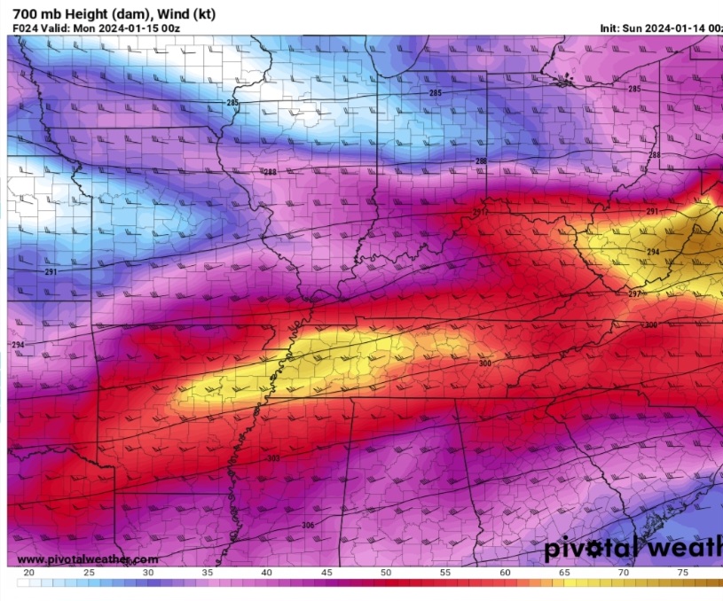
-
January 15th-17th 2024 Arctic Blast/Snow Event
TellicoWx replied to John1122's topic in Tennessee Valley
As the NAM plays out, it takes the jet more to the half moon look in KY...hence the valley doesn't end up like the other modeling. -
January 15th-17th 2024 Arctic Blast/Snow Event
TellicoWx replied to John1122's topic in Tennessee Valley
You wanna be near and just to the south side of the yellow basically -
January 15th-17th 2024 Arctic Blast/Snow Event
TellicoWx replied to John1122's topic in Tennessee Valley
18z vs 00z NAM 700mb wind (jet streak) -
January 15th-17th 2024 Arctic Blast/Snow Event
TellicoWx replied to John1122's topic in Tennessee Valley
A second streak should enter from the south...NAM has been taking it due north almost...everyone else brings it up in a NE direction...that makes or breaks the eastern valley -
January 15th-17th 2024 Arctic Blast/Snow Event
TellicoWx replied to John1122's topic in Tennessee Valley
Where that streak enters out of AR...whether KY or MS border tells the rest of the run -
January 15th-17th 2024 Arctic Blast/Snow Event
TellicoWx replied to John1122's topic in Tennessee Valley
Thank you to whoever posted the retired Met twitter post earlier...it unlocked the key. The driver of this system is a 700 jet streak...NAM was up in middle KY, everyone else Middle TN...NAM took a half step that direction. You wanna be on the right side entrance of that jet (basically south side of it)


