

brooklynwx99
-
Posts
6,215 -
Joined
-
Last visited
Content Type
Profiles
Blogs
Forums
American Weather
Media Demo
Store
Gallery
Everything posted by brooklynwx99
-
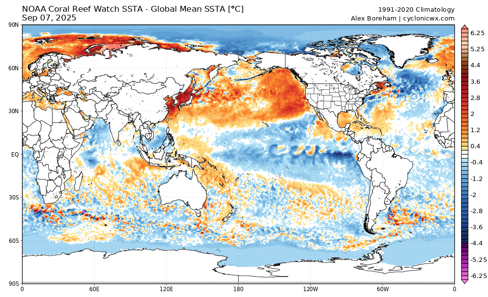
yeah, lots of warm water off the WC and in the GoA
-

2025-2026 ENSO
brooklynwx99 replied to 40/70 Benchmark's topic in Weather Forecasting and Discussion
no chatter about NPAC SSTs lately? PDO rose quite a bit in the last couple of weeks. that's also a ton of warm water off the WC
-
2025-2026 ENSO
brooklynwx99 replied to 40/70 Benchmark's topic in Weather Forecasting and Discussion
so you think that we're going to need a major volcanic eruption to see a 50"+ snowfall winter in NYC? I find that hard to believe given how much more moisture is available when cold air is around. seems like a bit of a stretch -
2025-2026 ENSO
brooklynwx99 replied to 40/70 Benchmark's topic in Weather Forecasting and Discussion
is it really? we had four 50"+ winters out of six from 2009-10 to 2014-15. it was ridiculous we also had similarly crappy stretches in the 70s-90s, we just had a lot more 10-15" winters than the single digit ones (not all that much better IMO) -
2025-2026 ENSO
brooklynwx99 replied to 40/70 Benchmark's topic in Weather Forecasting and Discussion
i earnestly believe that some of what's been occurring for the last few years is regression to the mean that 20 year stretch was insane... NYC averaged 34" of snow from 2002-03 to 2020-21. that was not going to last -
2025-2026 ENSO
brooklynwx99 replied to 40/70 Benchmark's topic in Weather Forecasting and Discussion
although I didn't like the results, I would run the 500mb pattern back in a heartbeat. that winter was a clinic on how to get the least amount of snow with favorable 500mb patterns
-
2025-2026 ENSO
brooklynwx99 replied to 40/70 Benchmark's topic in Weather Forecasting and Discussion
looking at RONI, the MJJ this year is -0.4 and last year it was -0.45. i also don't take the N ATL SSTs into account all that much, I find correlations with our weather pretty weak. even though the heatwave near Japan is stronger, the SSTs off the WC are also higher, so the PDO is about the same. if anything, it was more consistently under -3 last year overall, I think there are a lot of big picture similarities. I don't like to get too granular with LR forecasting -
2025-2026 ENSO
brooklynwx99 replied to 40/70 Benchmark's topic in Weather Forecasting and Discussion
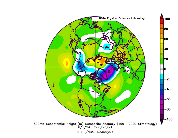
looking at the 500mb patterns over the last two summers, last year is a good match... had the same +NAO/+AO as well as the dual ridges over the western and eastern US. last year is also a good PDO, solar, and overall ENSO match as well. I think it holds a good bit of weight
-
2025-2026 ENSO
brooklynwx99 replied to 40/70 Benchmark's topic in Weather Forecasting and Discussion
I'm a fan of the EP Nina look showing up. most seasonals keep the EP Nina into the winter, which would bode well for EC cold/snow prospects overall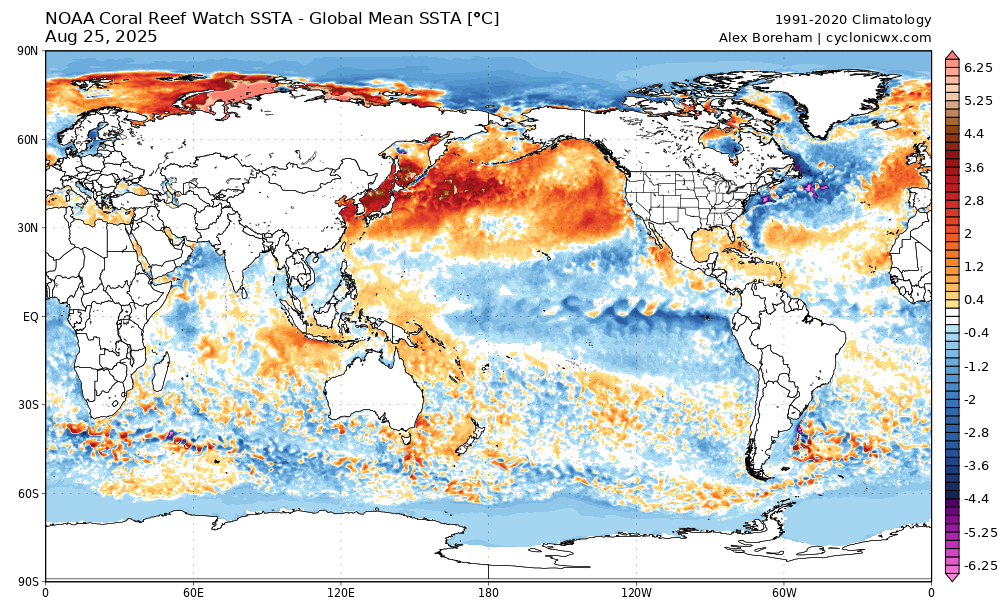
-
2025-2026 ENSO
brooklynwx99 replied to 40/70 Benchmark's topic in Weather Forecasting and Discussion
i wouldn't say that considering that -EPO and some +PNA is favored. definitely doesn't look like a disaster -
-
2025-2026 ENSO
brooklynwx99 replied to 40/70 Benchmark's topic in Weather Forecasting and Discussion
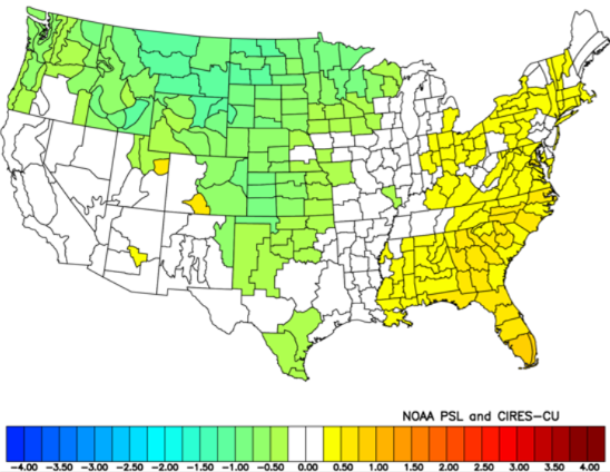
this is what i'm thinking for the winter pattern this year when looking at preliminary analogs. overall, I think we'll be looking at a winter with lots of ridging over the WC (or least nearby), likely pushing poleward into AK and north of Siberia, promoting -EPO and +PNA. this will displace the TPV SE at times, and although a SE ridge likely shows in the mean, it's likely suppressed for a decent portion of the winter Dec can feature some blocking, aided by the -QBO. I think the blocking certainly eases by Feb, but even then, the propensity for +PNA/-EPO should prevent a full on torch in the East. Jan is likely more +PNA driven, becoming warmer late in the month my main reasoning is that we're going to enter into a cool neutral ENSO state (weak Nina per RONI), and it's increasingly likely that the Nina influence will be more east-based, allowing for more ridging into the WC and AK rather than a flat ridge over the NPAC. we're also looking at high solar, a -QBO, and a -PDO overall, my top analogs are 2024-25, 2021-22, 2001-02, and 1989-90 (I don't think we'll see an AK vortex like 2001-02, but it scored well with ENSO, PDO, and solar). I think the best analog for this winter is last winter, as the ENSO, PDO, solar, and similarities to last summer's pattern are hard to ignore temps are slightly AN in the east with solidly BN precip (though it shouldn't be quite as dry as last winter)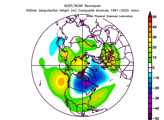
-
with variance due to climate change, I would argue that the large storms that do occur, even with lower frequency, would be bigger than the ones that we've classically seen. 2016 wouldn't have been quite as impactful 30 years ago
-
2025-2026 ENSO
brooklynwx99 replied to 40/70 Benchmark's topic in Weather Forecasting and Discussion
I suppose you can say that the Pacific jet helped the for parts of the MA and South then, which saw snowfall far above normal last winter -
2025-2026 ENSO
brooklynwx99 replied to 40/70 Benchmark's topic in Weather Forecasting and Discussion
it isn't. last year is actually the best analog that i've found -
2025-2026 ENSO
brooklynwx99 replied to 40/70 Benchmark's topic in Weather Forecasting and Discussion
although the PDO is exceedingly negative right now and must be accounted for in winter forecasts, I wouldn't lose tooooo much sleep over it given the anticipated -EPO pattern, especially in Dec/Jan. we could very easily see behavior similar to last year where it ended up closer to neutral as the winter went on... we're likely going to see a bounce upwards with the way SSTs are behaving right now -
2025-2026 ENSO
brooklynwx99 replied to 40/70 Benchmark's topic in Weather Forecasting and Discussion
ECMWF seasonal is pretty close to what myself and some others are thinking... pretty solid tendency for -EPO early on with the TPV likely displaced into SE Canada at times. also a bit of a signal for blocking early on, too? wouldn't be shocking with the -QBO sure, it likely ends up 1-2F AN, but nothing prohibitive, and there will be spells where the pattern is actually conducive for snowfall. i'll take it -
2025-2026 ENSO
brooklynwx99 replied to 40/70 Benchmark's topic in Weather Forecasting and Discussion
from what i've seen, last winter looks like a really good analog for this one. when taking all relevant years into account, there should be a decent amount of poleward AK ridging with some blocking potential early on. however, Feb looks warm and should push the winter's temps AN -
2025-2026 ENSO
brooklynwx99 replied to 40/70 Benchmark's topic in Weather Forecasting and Discussion
from what I noticed while forecasting last winter, it was pretty damn windy with all of the NW flow days... I'd imagine the reason why it felt much colder was because daytime highs were typically cold for those troughy patterns and you got much less of those radiational cooling nights that really tank temps, keeping minimums up -
2025-2026 ENSO
brooklynwx99 replied to 40/70 Benchmark's topic in Weather Forecasting and Discussion
wouldn't be surprising if we had another -EPO dominant winter with intervals of blocking. still some -PNA, obviously. likely AN temps in the mean, but we'll probably have some colder intervals with blocking... overall, doesn't seem like too much of a deviation from last winter's vibe, which I would run back and see if the dice can roll a bit better -
2025-2026 ENSO
brooklynwx99 replied to 40/70 Benchmark's topic in Weather Forecasting and Discussion
there was a span of time where pretty much every KU pattern hit from like 2016 through 2021, and people got spoiled and thought that would continue... I am one of those people and have tried to remove that bias. it just happened so often that it was easy to assume that kind of loaded WB -NAO pattern would give a 75-90% hit rate - in reality it's much lower -
2025-2026 ENSO
brooklynwx99 replied to 40/70 Benchmark's topic in Weather Forecasting and Discussion
CC is absolutely a factor, that is not a debate. snowfall is just so prone to variance and we came off of such a torrid stretch that I want to give it another 10 year span to make sure that this isn't just regression to the mean. it'll probably be 75% bust, 25% boom seasons from here on out with very little in the way of true average -
2025-2026 ENSO
brooklynwx99 replied to 40/70 Benchmark's topic in Weather Forecasting and Discussion
agreed, that was always the main issue with that setup and made it a lot more precarious. if it had a true +PNA, easy KU. one could attribute that to CC, but we were never going to see perfect +PNAs with every setup. I think a lot of it is regression to the mean i agree with you that if this is still happening in a decade, it's time to have a serious convo -
2025-2026 ENSO
brooklynwx99 replied to 40/70 Benchmark's topic in Weather Forecasting and Discussion
yeah, that did not help. what was interesting was I remember the PNA ridge trending "better" as the event moved up, but the ULL deteriorated to the point that it didn't matter. just kinda became messy because of weird ULL stuff. they're finicky, always have been


