

USCG RS
-
Posts
2,799 -
Joined
-
Last visited
Content Type
Profiles
Blogs
Forums
American Weather
Media Demo
Store
Gallery
Posts posted by USCG RS
-
-
3 hours ago, cleetussnow said:
I got a flight to Houston landing Tuesday night. Appears to be a non starter. Thinking of switching to Austin - which may be west enough to be less impacted by the storm. Otherwise Dallas may be the best bet. Ultimate destination is college station. I absolutely need to be in college station on Wednesday.
Dallas.
-
 1
1
-
-
29 minutes ago, GaWx said:
The small hope I have is that Beryl struggles to re-intensify off of the Yucatan like the struggle of Isidore of 2002. Any thoughts? I remember this well. It was very large , which probably was a negating factor. Beryl is much smaller. Thus, my hope for a slow re-intensification like for Isidore is limited:
"The inner core of convection collapsed while over southeast Mexico, and upon moving northward and reaching the Gulf of Mexico again, it was a large but weak tropical storm. Conditions favored significant strengthening, but Isidore did not redevelop central convection until reaching the northern Gulf of Mexico. The strengthening system hit Grand Isle, Louisiana on September 26 with maximum sustained winds of 65 mph (105 km/h)"https://en.wikipedia.org/wiki/Hurricane_Isidore
To see how large Isidore was over the Yucatan, look at figure 4.a in here:
26 minutes ago, Windspeed said:The mid-to-upper flow around the ULL over the western GOM combined with Beryl's forward motion seems to have thrown a wrench into forecast modeling. Beryl's center is north of the EPS again. The OPs have continued to shift north. This does two things: 1) obviously increases threat up the Texas coastline and 2) tracks Beryl further away from the influences of shear and stable airmass and into a region of higher divergence aloft. How well does Beryl's core hold together this evening before reemerging? How quickly can the vortex regenerate? Honestly, I am getting a little uneasy for a potential major hurricane landfall now.
Look at that outflow both Poleward and Equatorward already. That core is resilient and in tact.
-
2
-
 1
1
-
-
25 minutes ago, 40/70 Benchmark said:
I think a healthy cat 1 is a good bet.
Respectfully, I think SE Texas should prepare for a major hurricane. I pray I'm wrong but.. That core is relatively in tact and it moved over less land than initially thought. Combine that with very warm waters and South Texas really needs to be on alert.
-
3
-
-
42 minutes ago, Jebman said:
Central pressure is up to 961. That's up from the mid 930s. It's getting weaker.
Now that the core is finally disrupted, perhaps we can see this truly weaken.
-
Scanners are saying that this tornado is a MILE AND A HALF wide.
-
2
-
 1
1
-
-
Just now, canderson said:
It went right over Barsndall
Looks to have engulfed the entire city.
-
Tornado Emergency has been issued for Barnsdall
-
Barnsdall looks as if the entire town is about to be engulfed.
-
4 minutes ago, Sydney Claridge said:
The storm approaching Barnsdall, if it holds together, is on a track that would take it into (or at least close to) Bartlesville in around 30 minutes. Hopefully that line to the west will catch up to this supercell soon.
Barnsdall is about to take a direct hit from looks to be at least an EF4 tornado with a large to massive diameter.
-
1
-
-
16 minutes ago, RedSky said:
Hopefully not an 8.8
")
-
16 minutes ago, JetsPens87 said:
9.4km depth vs 4.7km depth for the first.
Not sure if that has any implications?
This is a good quick explanation: https://phys.org/news/2016-08-difference-shallow-deep-earthquakes.html
In general the depth between two, from what I have researched, appears that it would not make much difference in the grand scheme.
-
1
-
-
Just now, LibertyBell said:
Baltimore reminded me of The Mothman Prophecies. That was based around another bridge collapse and the happenings around that time were creepy to say the least.
Yeah... that movie haunted my childhood.
-
1
-
-
7 minutes ago, LibertyBell said:
Yeah this registers a 0.8 on the Long Island Traffic Index
Listen - I saw that movie and was like.. Hmm. Then Baltimore happened. Just saying

-
1
-
-
9 minutes ago, JetsPens87 said:
Not to say it couldn't or never happens but USGS does say it is exceedingly rare.
My apologies here, I did not mean to ignite a firestorm. I was trying to say it comfortingly.. but.... alas, I missed.
-
 1
1
-
-
2 minutes ago, MJO812 said:
4.0 magnitude in the same spot
At least it looks like the main event was this morning and that these are aftershocks, rather than foreshocks (admittedly much more rare). That, or the US has taken North Koreas idea and began underground testing

-
2 hours ago, coastalplainsnowman said:
Honest question - is there anything in a meteorologist's training that would make them particularly knowledgable about earthquakes? I ask because most of the on air folks I'm watching today seem to be struggling. Granted, they're being asked to make a story out of something which, other than some shaking and the novelty of it, is a not much of a story, but some of it is frankly tough to watch.
Meteorology and seismology share some common ground, yet they represent distinct scientific disciplines. I suspect producers may assume all scientists are interchangeable, but in reality, understanding seismology requires independent study. While an atmospheric scientist might manage to gather basic knowledge through quick research, a deeper understanding typically necessitates dedicated study.
-
1
-
1
-
-
2 hours ago, bluewave said:
I would not want to experience anything stronger than this.
I went through a 6.6M earthquake in San Luis Obispo in 2003. I still tense up when trucks pass by at times.
-
1
-
-
On 2/11/2024 at 10:50 AM, Allsnow said:
Probably never see this again…
Ah shucks, now I miss my childhood and parents
-
9 hours ago, LongBeachSurfFreak said:
97/98 was full of benchmark rainstorms. Little bit different scenario, with the entire continent flooded with pacific air, but same net result.
I hated 97/98. Absolute horrific winter.
-
1
-
-
11 hours ago, SBUWX23 said:
Not really sure but Bernie Rayno says follow the 528 thickness line, but that was news to me
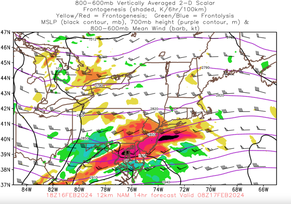
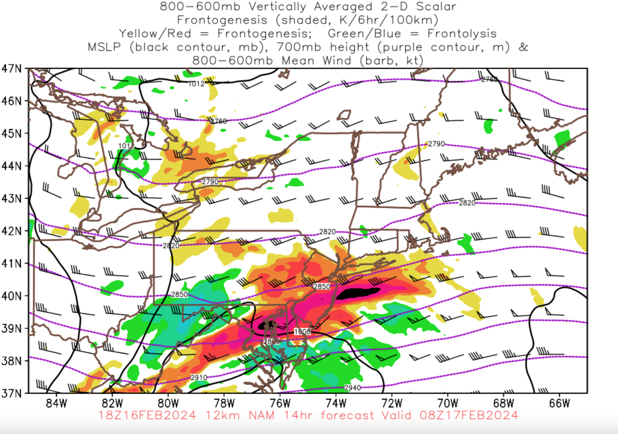
10 hours ago, RCNYILWX said:Amounts like what occurred are essentially impossible to predict but the existence of the strong banding signatures are handled better by today's modeling. This was strong mid-level f-gen, good jet dynamics, and the combined robust lift being well aligned with a very deep and saturated DGZ.
You could find guidance that showed on planar view and cross sections the strong f-gen circulation, good RH, and slantwise instability, the issue is the exact location and the ratios under banding of that nature. I think the HRRR did an excellent job with the depiction of the band on simulated reflectivity.
When you see something like that, you just kind of have to throw out the verbatim snow outputs and assume a very narrow corridor of much higher ratios that could result in totals like what occurred even with QPF probably not being terribly far off, and even that would lbe too low and the gradient sharper than you could possibly forecast. The OKX AFD yesterday was excellent in hinting at what took place. Worth a read.
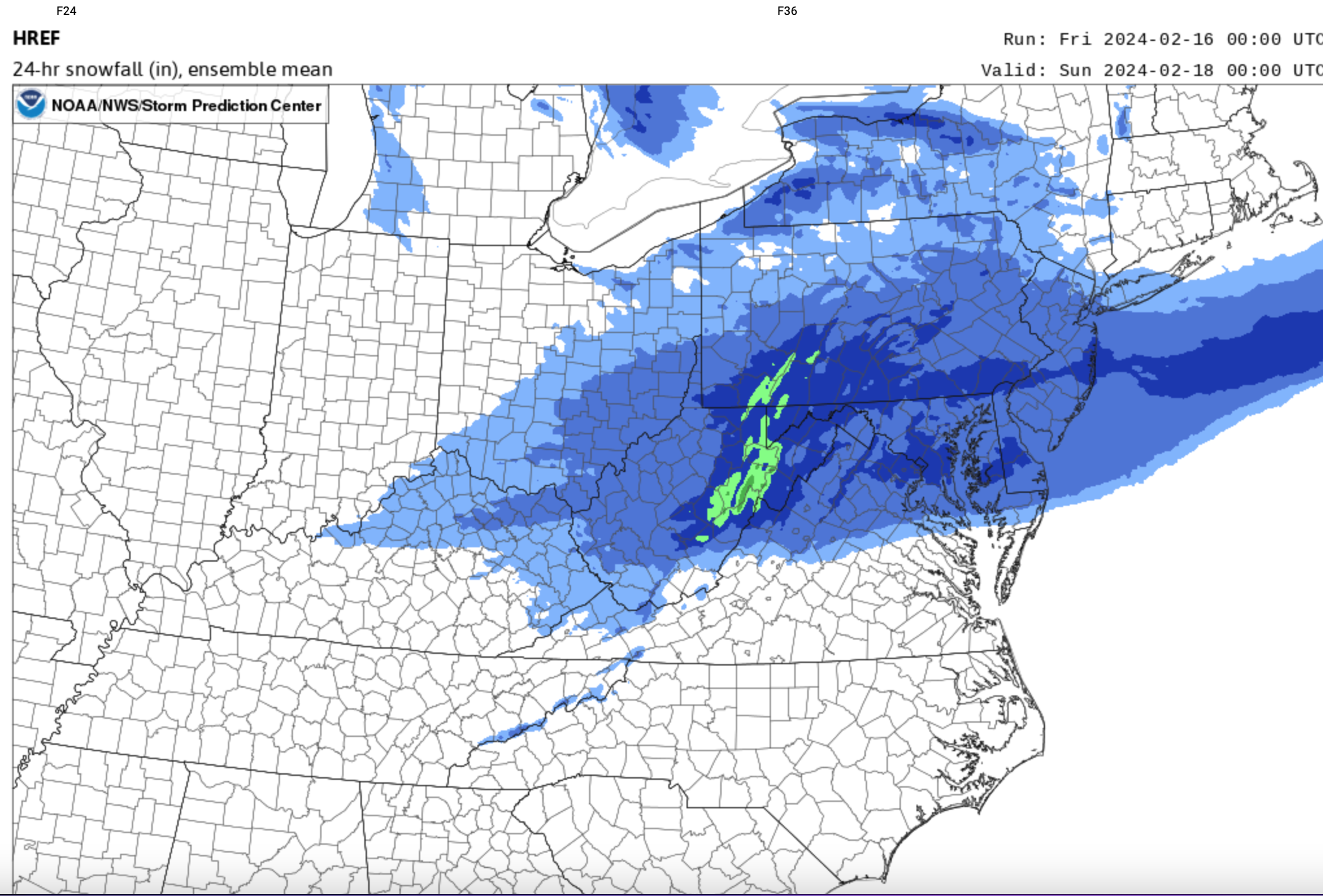
8 hours ago, wdrag said:The answer is yes. I’ll try to demonstrate with yesterday’s 12z. Guidance but w grand kids now. Probably 9pm tonight. It’s not exact bu I think we can do this within 60 mo either side in a 12-24 lead time. Demo later.
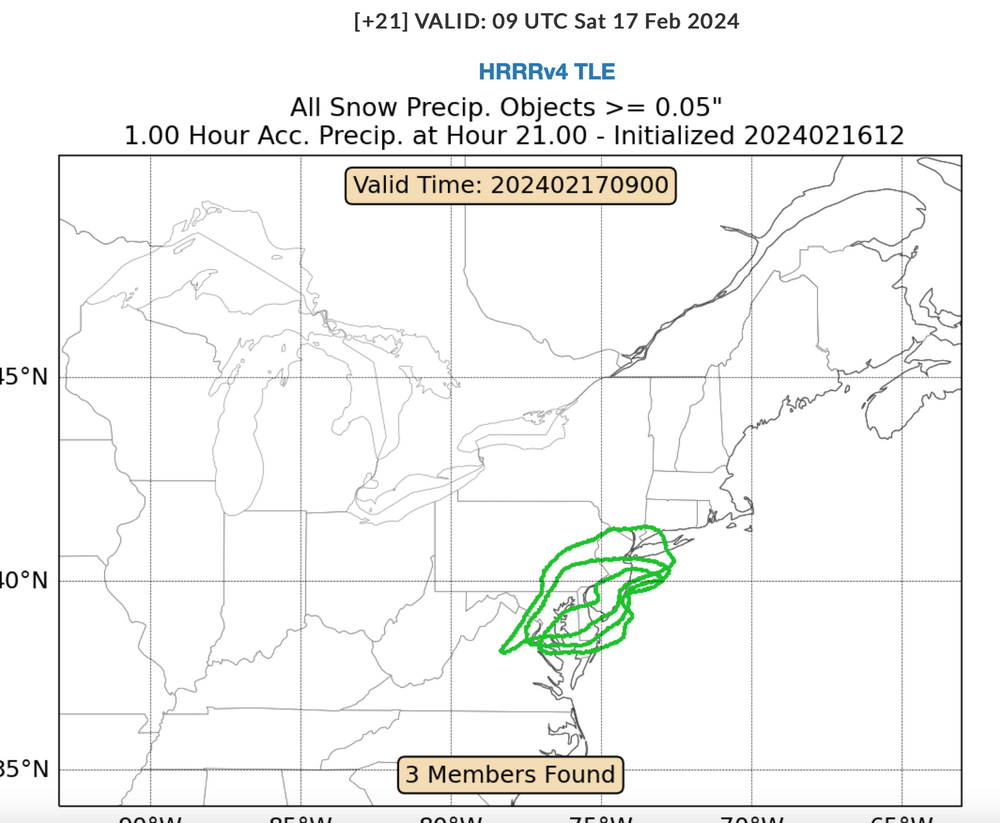
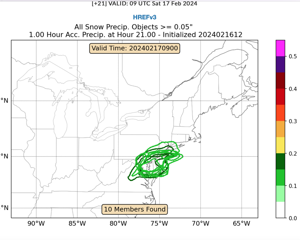
5 hours ago, wdrag said:https://www.wpc.ncep.noaa.gov/snowbands/view.php
The first two are from here, using .05 and .10 and you can see the members piling up. Scroll the time from start to finish and you see the evolution. I snapshotted this I can conference call this, though I have a sick grandchild so need to watch that situation.
Time snapshot 08z-09z/17.
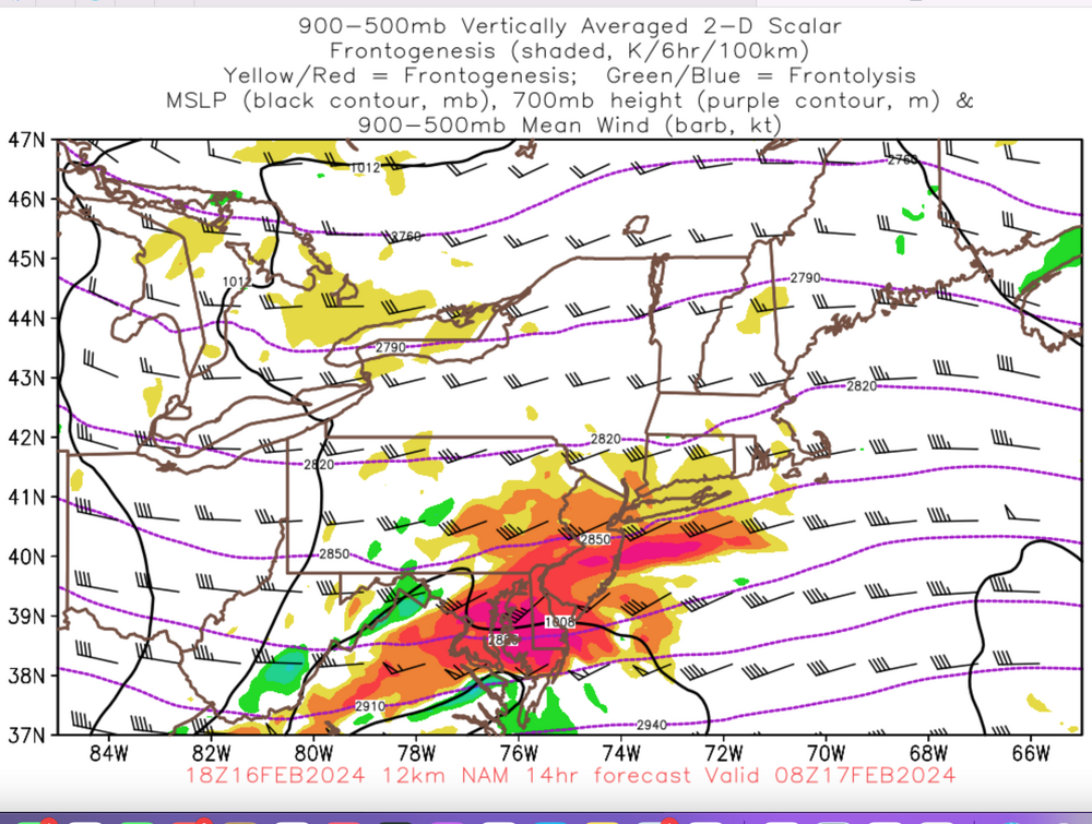
http://moe.met.fsu.edu/banding/. That's for the last two graphics 900-500 Fgen and 800-600 Fgen. Nam is my favorite...well defined and the lift is in advance of the red and black intense FGEN signal, downwind trajectory,
I closed with the HREF max axis forecast. Am sure that had something to do with the PHI initial;l warning,
Like the snow depth change graphics as a minimum amount, these are all worth checking-incorporating.

Thank you for all of this valuable information. It is greatly appreciated and something I will no doubt study more in depth to add to my repertoire.
@wdrag I hope your grandchild is feeling better. Also, you mentioned something about a conference call?
-
3
-
-
@SnowGoose69 @brooklynwx99 @wdrag @forkyfork @SBUWX23 or any other met, or someone with knowledge, who would like to chime in.
It appears that these types of bands are impossible to predict, even right up to game time. That's also what I've always seen said
That withstanding, is there anything that can point to where a band like this may set up - geographically prior to now casting? Or are we just not technologically advanced enough to see and predict where these will set up?
-
@SBUWX23 Man that weenie band missed long Island by the skin of its teeth.
-
5 minutes ago, SnoSki14 said:
One of these days we'll get a 4'+ blizzard. Climate change assisted snow bomb.
On my bucket list... It's a blizzard warning for July 4. Will we ever get it.. Who knows. But something I've always wanted to see.
-
1
-
-
2 hours ago, MJO812 said:
Coney island seems a little too much . Around 7-8seems more reasonable.
This was my area in south Brooklyn

Are your service drops (power lines to the house) always that low? Or is it just the snows weight?
-
1
-


Hurricane Beryl - Hurricane Warning - Baffin Bay to San Luis Pass Texas
in Tropical Headquarters
Posted
Exactly what I have been expecting/concerned about the past few days unfortunately. This core is incredibly resilient.