

USCG RS
-
Posts
2,800 -
Joined
-
Last visited
Content Type
Profiles
Blogs
Forums
American Weather
Media Demo
Store
Gallery
Posts posted by USCG RS
-
-
On 2/19/2025 at 7:55 AM, jm1220 said:
The IVT feature is the only one I’m really concerned about, the coastal low snow is 100+ miles away. And it’s hard to pin down and even the NAM doesn’t show being particularly heavy. Maybe someone lucky ends up with 2”. Otherwise it’s coatings to an inch.
Yeah this aged really poorly

-
Keep an eye on this. We are still 36 or so hours away and SR models want to back this coastal in. This is not a system to sleep on.
-
 1
1
-
 2
2
-
-
1 hour ago, psv88 said:
I remember that well, unfortunately. I got the flurries in western Suffolk while the east end got buried
Yes, I remember this quite well. I lived in Ridge at the time. 1999. We got nearly a foot and it was snowing really hard for a while there.
-
I could be-and have been before- wrong, but I've seen this song and dance before with the models in this set up. More often than not this area takes at least a significant hit.
I would most definitely keep an eye on this. There's a ton of energy around and we have a relatively good macro scale pattern. This is not over yet imo.
-
20 minutes ago, Monmouth_County_Jacpot said:
Anyone have snow maps on 18z euro?
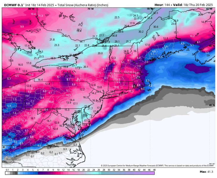
Only to Hr 144. Still snowing for the subforum at this point.
-
5
-
 1
1
-
-
2 hours ago, LibertyBell said:
wow so the lightning actually hit the snow and melted it? how fascinating!
To my understanding, it was more that the latent heat from the sheer amount of lighting in the atmosphere was enough to cause the heat to melt the snow.
-
1
-
-
3 hours ago, SRRTA22 said:
Thundersleet!!!
So, during Nemo (Feb 2013), when the two streams actually phased, there was so much volatility and upward motion that it created a significant amount of lighting. This led to so much latent heat release that thunder snow turned to thunder sleet for nearly an hour. It was not the layers of the atmosphere, it was the actual lightning causing the snow to melt and then it refroze before hitting the ground. I always found that fascinating.
-
1
-
-
34 minutes ago, brooklynwx99 said:
the equatorward shift in the jet is really helping the -EPO
I have always loved the EPO as an indicator for snow in the NE. I will take a -EPO over just about any teleconnection.
-
3
-
-
2 hours ago, NorthHillsWx said:
Pretty awesome watching it snow at 21 degrees. Not normal here
This honestly feels like when I used to live in Long Island.
9 minutes ago, Stormlover74 said:Based off the earthcam myrtle beach looks to have gone over to sleet...or at least a mix
Have family in MB - reportedly a mix
-
2
-
-
1 hour ago, lilj4425 said:
Can’t even get out of my neighborhood. The police department (Mauldin) has the road outside of it shut down here.
Simpsonville actually is not that bad...
-
5 minutes ago, Brick Tamland said:
From now on we only acknowledge the RAP and NAM.


As long as it shows us with the most snow**
-
 1
1
-
-
4 minutes ago, CoastalWx said:
As a New Englander, I'm in awe. Bands like we dream about from MSY to PNS. This is incredible.
Should have moved with me down South
")
-
2
-
-
6 minutes ago, Brick Tamland said:
Sounds great. But what good ol days is he referring to? Isn't he only in his 20s?
Some of us were born old.
-
1
-
5
-
-
1 minute ago, DeltaPilot said:
As a pilot ive seen some pretty crazy stuff with regards to snowfall and coverage. From higher altitudes its hard to fathom how the line can be extremely abrupt. Like someone painted the earth with
a brush.
If someone had a picture... We would all be really thankful.....
-
1
-
1
-
-
Just now, Silver Meteor said:
How the heck can New Bern get 8" with Greenville up the road only 2"? I can't imagine a gradient like that here on the coastal plain for such a short distance but of course anything's possible. When's the last time you got 8" down there?
Not with this storm. No.
-
3 minutes ago, Brick Tamland said:
Hope that will translate further north.
You appear to be right on the cusp. Given the pattern and movement, I would not be surprised if you get a moderate hit.
-
2
-
-
1 minute ago, lilj4425 said:
And here we can barely get a dusting in three years. Makes no sense.
Weather is a fickle mistress
-
Just now, NorthHillsWx said:
Yep. It’s a firehose into NO
New Orleans is getting crushed.
-
1
-
-
9 minutes ago, cbmclean said:
So some years ago I thought the whole notion of "the models will change when the storm gets better sampled over land" was ridiculed into oblivion along with the "18Z models are trash" myth. I was told that the vast majority of model ingestion is from satellite soundings and that RAOBs were of much reduced importance. Now I'm hearing this idea being resurrected all over the place by people who seem to know what they are talking bout. So which is it?
Depends. The impact of additional storm sampling depends on several factors. When a storm traverses a "no-man's land," such as the central regions of Canada, or enters from the Pacific Ocean, additional ground-based observations can significantly improve forecast accuracy. This is particularly true for storms with high potential energy and complex dynamics, where sampling plays a crucial role. This need for enhanced data is why Hurricane Hunters are deployed for both tropical and mid-latitude cyclones. Conversely, when a storm moves through a populated area with an abundance of existing data sources, additional sampling typically has a minimal impact. In essence, computer models rely heavily on data quality—better data inputs lead to better outputs. Therefore, when data is sparse, targeted sampling can greatly enhance forecasts. However, when data coverage is already robust and the storm's behavior is less volatile, additional sampling tends to yield diminishing returns.
-
1
-
-
2 minutes ago, WXNewton said:
The trend is real on the NAM here is both of them, might even show Catawba County some love if this continues!!


Given the way things are going, I would say there is a good chance the trend if not finished either. The current synoptic set, combined with how juiced the LP appears to be already, I would venture to say this is going to trend NW still.
-
2
-
 1
1
-
-
8 minutes ago, wxdawg10 said:
WRAL gets a lot of blame for this storm..but were there any other outlets locally or nationally calling for more than a couple of inches around central NC? i don't remember. if so then i think WRAL can be let off the hook a bit due to a collective meteorological screw up
-
1
-
-
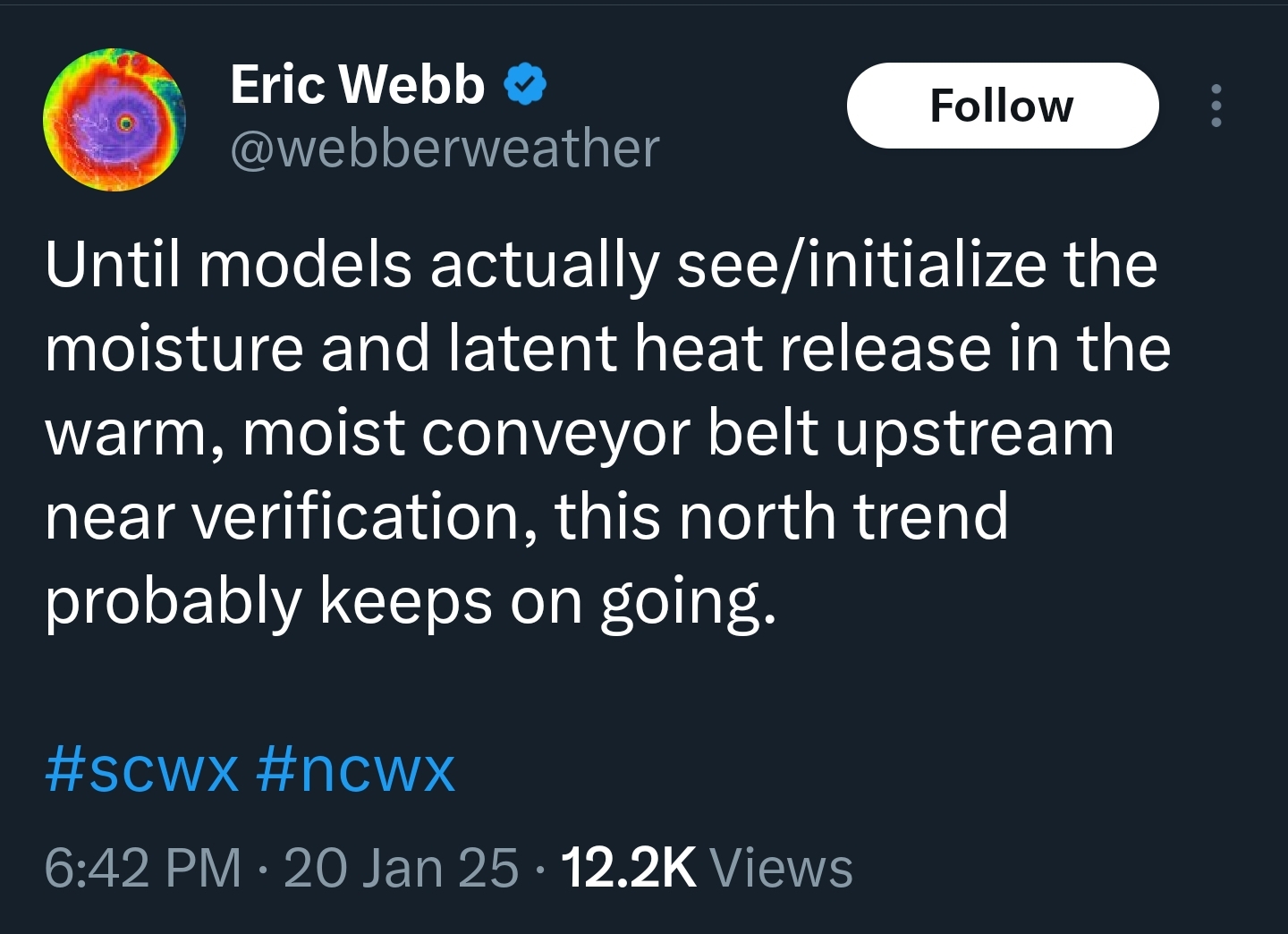
1 hour ago, BornAgain13 said:

Eric copying me...
On a serious note - it is nice to see that he thinks this is a potential real trend. -
13 minutes ago, NavarreDon said:
Hurricane Hunter is sampling out in the gulf to aid the models with this system.
.Given the current changes in models, I would not be surprised to see significant changes in the 00/06z runs. Not saying there will be, just would not be surprised.
-
3
-
-
3 minutes ago, WXNewton said:
Throw out your parachute!
42 minutes ago, lilj4425 said:Don’t do this to me. I had given up and cliff dived.
I am pretty good at SAR (Search and Rescue)...
1 minute ago, waronxmas said:If this verifies, expect ATL to be an absolute mess tomorrow morning. Everyone is under the impression that this storm is going to be a nothing burger in the city and impact middle GA more. Now where have I heard that before…
Good thing I work remote now.
This has to really dig, to provide a good hard hit for C GA North and into the Upstate of SC and W NC. That withstanding, it will be a good idea to watch the latent heat release of the storms in the Gulf overnight and into tomorrow morning. This will give a good idea of if this storm is really digging or not. Kind of like the JAX Rule for the Northeastern United States. If the storms are really firing, the latent heat release will help to pump the heights further NW and I would then expect that areas N and W of S GA and E NC and SC to be in the game.
-
5
-

Hurricane Erin
in Tropical Headquarters
Posted
What you linked is a great write up.