

USCG RS
-
Posts
2,799 -
Joined
-
Last visited
Content Type
Profiles
Blogs
Forums
American Weather
Media Demo
Store
Gallery
Posts posted by USCG RS
-
-
36 minutes ago, dogwoods said:
Hey y'all, wondering if I could get some help. I normally only ever lurk here during winter to see if there's snow brewing... but am always disappointed because I live in the Triangle, and there's a snow dome over Raleigh.
") But figured I'd post today on the off chance that it might lead to something.
But figured I'd post today on the off chance that it might lead to something.
Here's the deal. I have family up in the mountains of Avery County, NC. My sister volunteers for the Linville Rescue Squad. It's an all-volunteer group and she has been doing search and rescue work with them for a few years. They have been working around the clock since the hurricane hit and giving it their all. My sister didn't even shower for like six days, has been sleeping on the floor, going without hot meals, hiking around the woods in Avery county doing search and rescue... you get the drift. And the whole squad is just full of really decent people that are doing this, unpaid as usual.
Anyway, randomly before Helene hit, the Rescue Squad got selected to be a finalist in this contest through Land Rover. If they win, they could get a new vehicle and $25,000. That's CRAZY money for a volunteer squad that usually exists off of community donations.
Here's the link to the rescue squad:
https://linville-centralrescue.org/
And to the contest:
The only way they'll win is if people vote for them. First, I'm hoping everyone here will vote. But also -- I'm trying to get some more visibility for the contest through media outlets. Like this is such an easy way for people to help out, just click and vote in this contest, no donation or anything -- and it could go such a long way to help these guys and the people they serve. Think how much of financial and emotional impact it would have after everything they've been through. So I'm sort of trying to be a one-man PR team to help them out.
What would be amazing is if somebody like Brad Panovich or Ethan Clark could share this information on their facebook page since they have such a wide reach. I think the North Carolina Weather Authority has like 568k followers on Facebook, Brad has 374k followers... you get my drift. BIG reach. Does anyone know these guys? I tried to send them a facebook message, but I'm just a random person shouting from the void out of a million messages they're already receiving, and they probably thought I was just doing PR for Land Rover. (Unfortunately it does have free PR for Land Rover but I don't care about that other than the squad will get a free vehicle!)
So anyway, if y'all have any connections, please consider helping out and pass this message along. It's a really decent cause. Many, many thanks.
Voted!
-
 1
1
-
-
6 hours ago, eyewall said:
There apparently was a request for a few hundred body bags now for western NC.
Unforunately, yes there were.
-
On 10/2/2024 at 9:51 AM, WishingForWarmWeather said:
Yes, that definitely isn’t lost upon me. I guess I was trying to express that the devastation - regardless of level felt or perceived - is so widespread. I definitely didn’t mean it as a competition or anything.
No... No, of course not. Apologies if my tone was misinterpreted here. I was more just piggybacking off of the comment.
-
1
-
-
9 hours ago, WishingForWarmWeather said:
The impacts and devastation are just so widespread. Also I recommend going to that tweet and reading the entire thread. They continue on documenting how bad it was for them.
Unfortunately, this looks'good' compared to the western portion of the state and, of course, WNC. Some areas are literally just... Gone. There's no other way to put it. It's... Indescribable.
-
 2
2
-
-
2 minutes ago, DAWGNKITTEN said:
What does ACE maker mean?
Accumulated Cyclone Energy. It's a measure of energy for hurricanes. In this context it adds to overall index for the year (officials keep track of all energy produced by tropical cyclones each season)
-
2
-
 4
4
-
-
5 hours ago, Seminole said:
Filled out a missing person report for my son in Ashville, NC. I last heard from him Friday at 1:30 PM. He said he was on the second floor of his home and cut off from everything because of flood water and debris. The situation there is beyond dire.
Please keep your phone charged and on ring. Verizon is setting up a temporary cell tower in Asheville today. There is a chance he may be able to get a call to you. Just wanted to ensure you know about it.
There are no words otherwise.
-
3
-
1
-
-
I have been an emergency manager, first responder, medic, rescuer, risk manager or some combination of these for over 17 years. I have been through many deployments, storms, calls, etc. I have never witnessed this type of widespread devastation and catastrophe stateside. Ever. This includes living in NY though Sandy. It's sobering.
That's not to say there have not been comparable disasters in United States history. Likewise, we will all get through this, of this I have no doubt. However, I say it again, it is truly sobering what is/has taken place across the Southeast.
-
6
-
1
-
-
4 hours ago, nchighcountrywx said:
Being awfully quiet in our mountain thread I am concerned many are struggling with severe impacts from Helene.
Prayers for all and reach out if help is needed
https://x.com/ncemergency/status/1840028847292432671?s=46&t=FFGrWYuqJINrKdAyxhtzfg
Electricity and cell phone signal is simply gone in those areas. Same with upstate SC. I am just south of Greenville City and starting to get some cell coverage back, but Greenville City and NW up through the Mountain areas - it might as well be as if there is no infrastructure right now. I know comms for OEM is struggling and same with all rescue personell. This was a harder hit than expected, even given the warnings.
The good news - at this time - deaths are not as high as initially feared at this time yesterday. Unfortunately, long way to go.
-
4
-
-
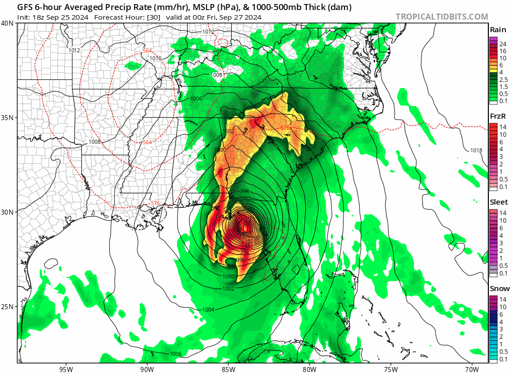
At this point, when Helene makes LF, it will still be strengthening. Like Michael appeared to do, we may actually see this storm strengthening over the first interactions with land as well.
-
1
-
-
Just now, csnavywx said:
I have >100 strikes a minute (426 strikes in last 3 min, 317 in 3-5m bin).
That energy/Latent Heat release is.. wow.
-
1 minute ago, Damage In Tolland said:
150 seems likely at LF
Unfortunately.
The friction of land actually looks to be assisting with with helping this gets its final act together.
-
2
-
-
1 minute ago, andyhb said:
Potential aborted recon mission here. This does not happen often at all from a TC itself.
A poster (I can't remember/find it a few pages back) literally just posted this link about a Hurricane Hunter in Hurricane Hugo - https://www.wunderground.com/hurricane/articles/hunting-hugo-part-5
Uncanny.
-
1
-
-
Just now, andyhb said:
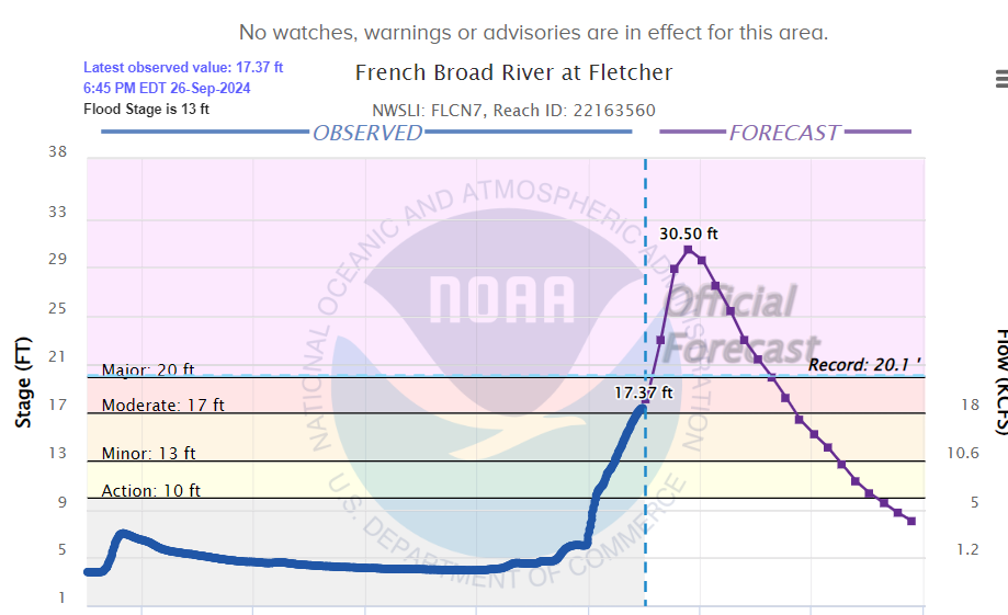
The French Broad River (river that flows through Asheville NC) is forecast to crest more than 10 feet above the previous record at Fletcher, which is in the eastern part of the metro.
Those warnings the GSP NWS Office was providing were something. I don't recall ever seeing language quite like that out of the NWS, at least to the public.
-
2
-
1
-
-
7 minutes ago, lakeeffectkid383 said:
I certainly don’t think they would do SAR until well after storm passes.
1 minute ago, Cincy12 said:lol If you mean SAR as in the FAA filing some paperwork stating that ultimately the cause death/wreck was a jackass flying into a hurricane, then yes, a SAR team will quickly handle this.
I won't derail the thread with this, so I won't say anything further after this - but you would be surprised what some teams will brave in an attempt to resuce persons.
-
2
-
-
Just now, SnowenOutThere said:
I bet that person has some insane music playing as he does it, lets hope they dont win a Darwin award though.
And now, if something goes terribly wrong, a SAR team is put in danger. Lovely.
-
28 minutes ago, SnowGoose69 said:
Seems reasonable now. 140-145 would not surprise me
Yeah.. I was questioning my call of 150 MPH at LF I made yesterday or the day before. I think its a distinct possibility. Becoming almost likely at this point and that is just going to cause more problems inland as well.
-
1
-
-
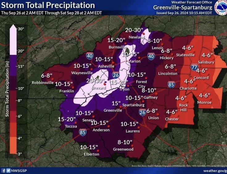
32 minutes ago, Eskimo Joe said:
FYI, if you see a rainfall graphic depicting 15" - 30" of rain forecast by the NWS in the hill county of South Carolina, it is made in error and not valid. They have since updated the infographic.
I will pass that along. Thank you.
-
1 minute ago, NavarreDon said:
Yeah the Greenville/Spartanburg Area is on full alert right now.
Red Cross has all hands on deck and the local AHJ is - concerned.
-
2
-
-
23 minutes ago, franklin NCwx said:
Historic!
Can you link this? I can't find that exact image and I would like to send it to some peeople. Thanks.
Edit: Nvm. Finally found it. Thanks though.
-
1
-
-
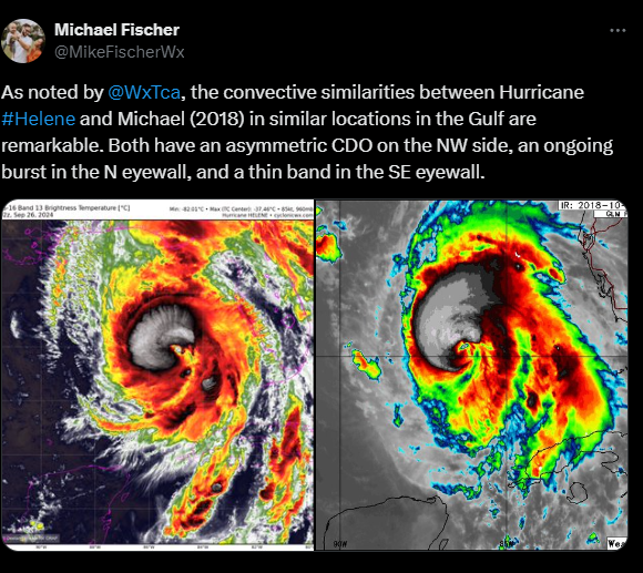
From Michael Fischer
-
8
-
1
-
 2
2
-
-
5 minutes ago, OSUmetstud said:
Yeah i thought that too, but after all of these issue today, im more on the side that the internal structure of the storm just isn't going to allow a lot of intensification before landfall. It's not like the models are really forecasting a ton of that anymore. Global and hurricane models really only seem to show slow intensification this afternoon up until landfall. Well see.
Yeah. It has been a slow process for this storm, which, given its' size I am not necessarily shocked (though I did expect greater strengthening by this time). That withstanding, the latest Vortex Message showcases a Closed eye and it is getting itself gradually more and more together. I noticed last night that the outflow of this storm is quite impressive, both poleward and equatorward. In fact, what came to mind was a favorable trough interaction process with what is over the Midwest/SE United States currently. If that trough can truly vent Helene with the really warm bath water she currently sits in.. I shudder to think of what happens, especially given the core getting its act togehter, and despite being such a large storm.
It, unfortunately, is a true wait and see game.
-
29 minutes ago, OSUmetstud said:
GFS continues the slowing trend.

That is worrisome. As most know, an extra 6 or 12 hours over that bath water is going to have singificant implications for organization and intensity.
-
-
26 minutes ago, wthrmn654 said:
Idk it kinda looks like the western flank that builds them just vanishes. With that said, it's not near the core/ center so it may not affect it much.
And some sort of weird clear blob near bottom right area of the center. I'm guessing some dry air from earlier

That western flank looks like trough interaction and outflow building to me. It looks pretty amazing from that perspective, imo
-
1
-
.jpeg.f97dbb93b2be004bd5f13dab8ba5988e.jpeg)
Major Hurricane Milton
in Tropical Headquarters
Posted
This looks to be a potentially large storm again. Furthermore, those just hit need to closely monitor this, if possible.