

USCG RS
-
Posts
2,479 -
Joined
-
Last visited
Content Type
Profiles
Blogs
Forums
American Weather
Media Demo
Store
Gallery
Posts posted by USCG RS
-
-
22 minutes ago, brooklynwx99 said:
NAM is notably lower with heights. always a bit hesitant to believe a warmer solution given a strong HP in an ideal location

Yeah, I've said this elsewhere. Models tend to erode surface cold too quickly and not quickly enough for upper levels.
-
 6
6
-
-
31F/~1". Side streets just started becoming covered.
Middle Island
-
1
-
-
1 hour ago, White Gorilla said:
Hats off to pro mets, you math geniuses. I wanted to become a pro met as a kid but my math skills weren't my greatest strength.
If I got a got through that class... I promise you can as well
-
1
-
 1
1
-
-
10 minutes ago, BxSnowWx37 said:
I wonder if they notice what's happening to the south and west of us..there is still a low sitting on the boundary while the approaching artic front and disturbance swing east.??..you can see some precip breaking out in the Virginia's.??
Yup. This was the meso LP the models were picking up on yesterday.
-
1
-
-
There is still good bit of precip to go for the metro and LI. That meso low looks to be providing just enough lift to give the area some potential issues. Going to need to be careful for the next few hours.
-
Coast is going to have to be careful here. SR Mesos seem to want to try and spin up a weak LP. If the cold front is far enough off shore, it could actually enhance precip just enough to provide some icing...
-
22 minutes ago, Rjay said:
A rapid melt is occuring with this snow eating fog.
Fog eats snow like a hungry linebacker after practice.
I have seen fog legitimately wipe out snowpack of over a foot inside of 3 hours.
-
1
-
-
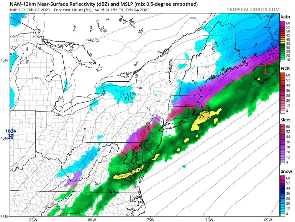
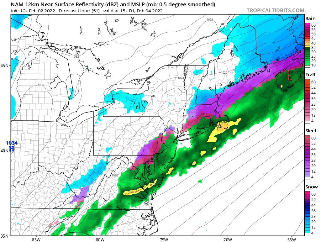
I think this actually has a higher ice accretion potential than many are giving it credit for. Low level cold air is going to drain down to the coast pretty well while the mid-levels are likely going to remain torched. We still have a considerable snowpack on the ground, and even with rain it's not going to completely disappear. Likewise, the cold air really means business here. I was originally thinking this would be either rain or snow for the area a few days ago, but I am genuinely concerned about a good bit of ice accretion here.
-
1
-
-
16 minutes ago, wishcast_hater said:
If a transmission line goes down it doesn’t matter if your lines are above or below ground.
Transmission lines going down is a grid issue.
-
3 minutes ago, NJwx85 said:
Similar to what?
The NAM is currently the slowest of all the guidance to bring the cold air in at the surface and is weakest.
With ice accumulations for the tri-state and into SE upstate NY. Granted the FV3 is more bullish otherwise.
-
1 minute ago, NJwx85 said:
FWIW

12k NAM ended up looking similar in the end, no?
-
45 minutes ago, Brian5671 said:
NAM coming in warm for the area (outside of far north and west) precip is mostly done by the time the real cold air arrives
Good.
-
22 hours ago, SnoSki14 said:
That's fair until the other models trend towards GFS.
This is something the GFS -in theory- should do better with, as much as I really do not like that model.
That withstanding, I thought the TPV would win out, but the SER is a bit stronger than previous runs and this means the tri-state area is right on that ZR line. Not a good look rn and the metro looks to be square in the crosshairs.
-
1
-
-
4 minutes ago, NEG NAO said:
an ice storm can shut things down faster and more dangerous than a snowstorm-time to start stocking up on various ice melt.....
A generator would not be a bad idea either. Unfortunately.
-
41 minutes ago, MJO812 said:
With the position of the high and the strength, expect this to trend south.
More than likely.
-
1
-
-
2 minutes ago, NJwx85 said:
You have to see how shallow the warm air is. If most of the column is cold or if the warm layer is above 925mb that would favor more sleet.
Of course.... I just do not trust soundings at this range, especially given the set up.
-
1
-
-
5 minutes ago, White Gorilla said:
Better shape in terms of warmer rain or colder snow?
To me - the odds favor either plain rain OR snow, at this time.
Long way to go.
-
2
-
-
2 hours ago, crossbowftw3 said:
And then snow on top of that is a recipe for disaster.
It appears that a crippling ice storm is going to hit part of the country.
Fortunately, the tri-state area looks to be in better shape - for now. Given the strength of the HP, I would not rule such drastic SE shifts as the 06z at this time.
-
1
-
-
47 minutes ago, BxEngine said:
Or maybe the moderators have jobs and lives and we should probably expect adults to act like adults instead.
You know this will never happen. Ever.
-
2
-
-
2 hours ago, jm1220 said:
Yes they did-the convection really did mess the storm up somewhat.
Without the double barrel low... What could have been.
-
6 minutes ago, BxEngine said:
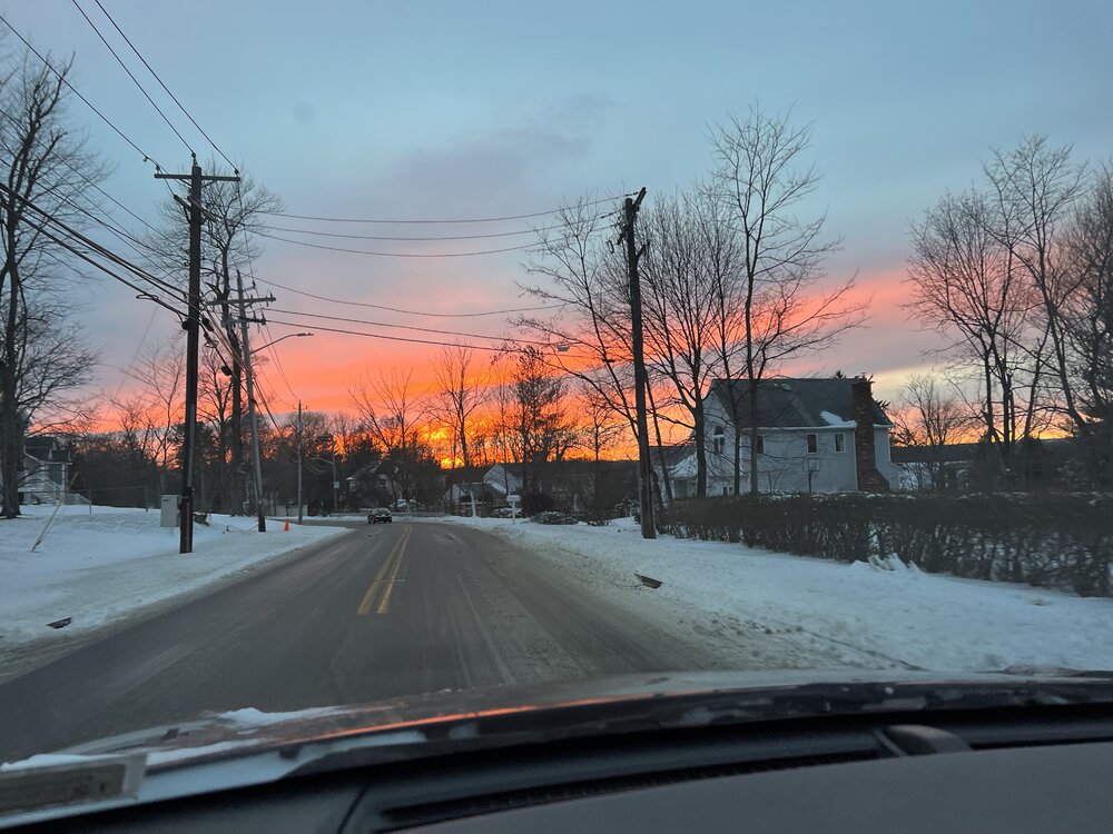
In my car so pics suck lol

Wow.
-
1 minute ago, EasternLI said:
Man, if this thing was captured a bit west like models had at one time. Those hefty snowmaps would have verified.
This would have been destructive if it had, tbh. I'm not exactly sad it didn't, even though I kind of am. If that makes sense haha
-
1
-
-
-
Just now, jm1220 said:
Maybe a convergence area off the sound as well. That seems to happen with these storms.
Yea... Upton AFD talked about something like that
"Have also noticed some enhanced
reflectivities west of the large band, which may some
enhancement off the Long Island Sound in the strong N flow."


February 24/25 Potential Winter Storm
in New York City Metro
Posted
I think the tri state is going to have to watch for the potential of Zr. Pretty ripe set up for ice imo.