

USCG RS
-
Posts
2,799 -
Joined
-
Last visited
Content Type
Profiles
Blogs
Forums
American Weather
Media Demo
Store
Gallery
Posts posted by USCG RS
-
-
7 hours ago, brooklynwx99 said:
this is nearly perfect. the EPS is holding serve on a legitimate KU evolution for next weekend


-
 2
2
-
-
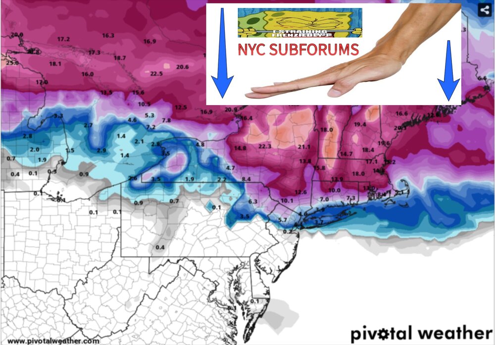
3 minutes ago, jm1220 said:
Good thing the heavy echos are doing their thing and looks like the sleet line retreats a bit under them.
The battle rages over LI, but it looks like LI wins this round...
-
-
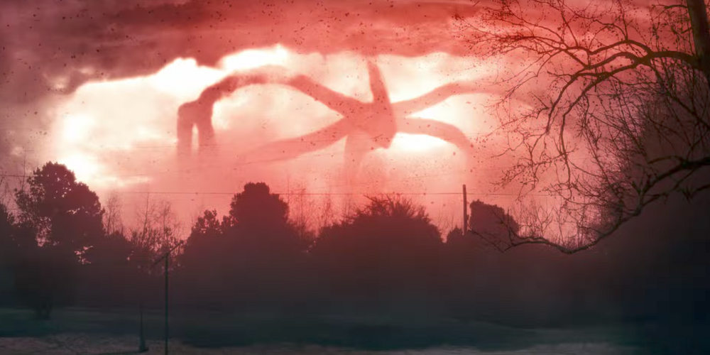
25 minutes ago, Jaguars said:
Weird looking presentation on radar, looks like it has tentacles.
.
-
2
-
 1
1
-
 1
1
-
-
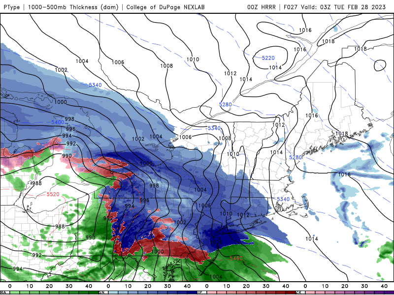
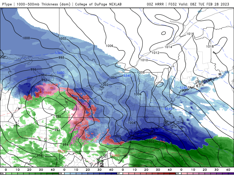
17 minutes ago, jm1220 said:
HREF essentially a carbon copy from 0z-4-6” for most of the city and LI, 2-4” extreme S shore, 6”+ for most north of the city. A little surprised. Hope it’s right.
Honestly - I would not be surprised if WSW are pushed further south this evening or overnight (as the storm begins). There is a significant amount of energy with this system and High Res models continue to show rather strong h7 dynamics.
-
1
-
-
1 minute ago, Brasiluvsnow said:
do tell
-
1
-
1
-
-
1 minute ago, jm1220 said:
All about where the sleet line makes it to, as usual. The dual pol radar'll be our best friend or worst enemy tomorrow night. NAM is more aggressive with the mid level warmth as usual but it can sometimes overdo it. If the coastal low takes over fairly early it should help mute the northward warm push. If we have shredded up precip the warm mid level air will have an easier time getting a foothold. And I do buy the big difference between south and north shore snow/frozen amounts here. Hopefully everyone gets a decent event and for most it'll multiply our seasonal snow total by several times or more so there's that.
The NAO is flexing. Likewise, I agree that the NAM tends to overdue mid level warmth.
As far as a thump, h7 actually looks pretty primed over the metro area. It appears we are becoming the battle ground, which bodes well for higher end snow for the area.
-
7 minutes ago, SnoSki14 said:
Let's not count our chickens yet. We're still very much borderline
I said NYC still got to play those cards...
Maybe NYC is Kenny Rogers this year
")
-
2 minutes ago, SnoSki14 said:
Yeah things are trending towards the Euro.
It's almost hard to believe that we might get accumulating snow this winter.
NYC plays it cards right and we might actually see an average season. In theory, we could see an above average snowfall after this dismal winter.
-
1
-
1
-
-
1 hour ago, Allsnow said:
3k nam Even colder
Considerably so.
-
1 hour ago, Cfa said:
Middle Island:

No accumulation anywhere else.
At least the dogs and cats will be able see it on their way out
-
45 minutes ago, EastonSN+ said:
I should add this is highly dependent on the RNA. If it stays be below -1sd then the target period can end up a bust. RNA driving the bus (a factor of the Aleutian ridge due to la Nina).
Question: when did the -PNA terminology change to RNA?
-
1
-
-
-
-
2
-
 1
1
-
-
1 hour ago, Stormlover74 said:

-
2 hours ago, donsutherland1 said:
Winter 2022-23:
Tornado warnings: 1
Winter storm warnings: 0

-
1
-
1
-
1
-
-
7 hours ago, TauntonBlizzard2013 said:
So is Tony Mazz still going to be employed at the sports hub at the end of the week?

-
Btw... Has anyone in here dealt the residue from the rain and the chlorine smell that has been talked about?
-
2 hours ago, MJO812 said:
360 hours
Damn. Snowman all grown up is
 . We need at least 1 person who believes in magic..
1 hour ago, brooklynwx99 said:
. We need at least 1 person who believes in magic..
1 hour ago, brooklynwx99 said:you guys always might be onto something and then you go right off the deep end. why?
I'd vote human nature...
-
1 hour ago, Great Snow 1717 said:
Since November 1st how many images have you posted? And how many of those images have verified????
Heres an idea. Go to school. Get the degree. Dedicate your life to a passion. Study it. Get to actually know it.
Can't do that? Don't want to? Don't have the wherewithal for it? Fine. We all have our gifts. We all have our strengths. But don't attack someone else's strengths because you're frustrated over this winter and want someone to blame instead of taking the time to understand an expert who volunteers their time for your benefit.
Oh and.. Maybe read your posts before hitting submit. Even the least educated of a group (I am specifically referring to meteorology here) is unknown when they remain silent on a subject they know little about.
-
6
-
1
-
-
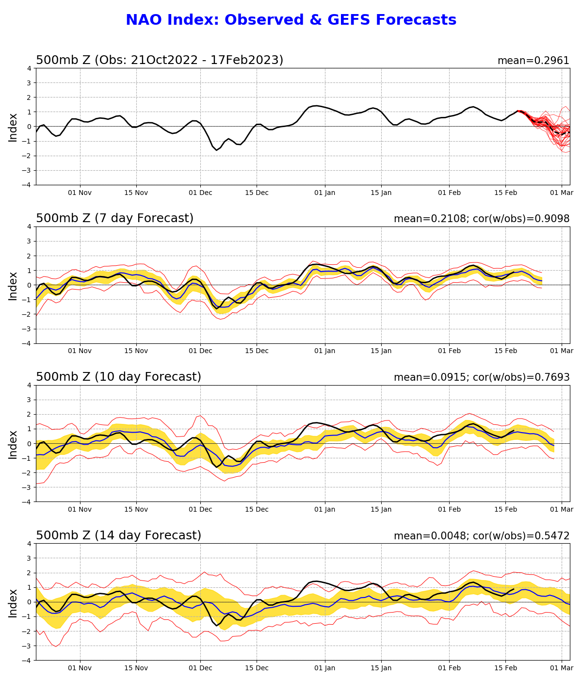
21 minutes ago, GaWx said:
The GEFS (used in CPC daily updated charts for indices) based NAO forecasts have gone markedly in the -NAO direction over the last 4 day period:
- The 2/13 forecast had only 2 members (~6%) with a sub -0.25 NAO (what I consider -NAO) on 2/27. The mean for 2/27 on the 2/13 run was up at +0.5 vs 0 on the 2/16 run and -0.3 on the 2/17 run.
- The # of members with a -NAO on 2/27 rose sharply on the 2/14 run from 2 to 8 members (~25%).
- The 2/15 and 2/16 forecasts each had ~10 members (~33%) with a -NAO on 2/27.
- The 2/17 forecast has ~15 members (~50%) with a -NAO on 2/27.
- So, the progression from the 2/13 run to the 2/17 run has been 2 to 8 to 10 to 10 to 15 members with a -NAO on 2/27.
- The 2/16 forecast had ~10 members (~33%) with a -NAO on 3/1 vs ~23 (~75%) on the new one
- The 2/16 forecast had only 3 members (~10%) with a sub -1 NAO (what I consider a strong -NAO) on 3/1. The 2/17 forecast has 10 (~33%).
- The 2/16 forecast had 12 members (~40%) with a +0.25+ NAO (what I consider +NAO) on 3/1 vs only 3 (~10%) on the 2/17.
With this trend toward -NAO for 2/27-3/1+ remaining strong even on today's run as per the above, I wonder if the trend will continue to an even stronger -NAO over the next few days of runs as the models get an even better grasp of the downwelling of the major SSW that won't peak til tomorrow (as per the 10 mb 60N winds). Keep in mind that the main period in question (2/26+) is still 9+ days out, which for this uncommon situation (a major SSW with a dip to ~-15 m/s 10 mb winds at 60N) is probably not the easiest for the models to handle well.Also, are the models correct in keeping a +AO with this increasingly strong progged -NAO? Or is the modeled AO going to start dropping if the progged -NAO keeps strengthening? I especially wonder about this since a strong -AO is often the hallmark of a successfully downwelled SSW.
What do others think?
--------------------------------
2/13/23 GEFS based NAO prog (see middle graph): look at how + it was at end (for 2/27) with only two members having a -NAO!

2/17/23 GEFS based NAO prog: look at the huge drop in it as of 2/27 vs just 4 days ago with half the members now having a -NAO that day (vs only 2 members 4 days ago) and almost all having a -NAO by 3/1:
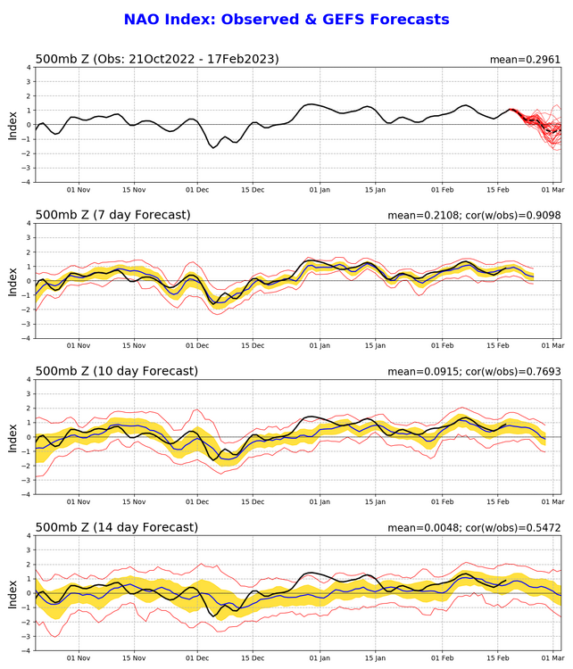
Heck of a Write Up. Thank you for this.
Regarding thoughts, I think that we are poised to go into a period of wintry weather. Classic blocking patterns are beginning to show up on several of the deterministic runs and the GEFS is beginning to catch on as well. The GEFS is not perfect, but it does have it strengths, with one of them being the earlier recognition of large scale pattern shifts. I think we are beginning to see that here.
-
2
-
1
-
-
On 2/15/2023 at 1:12 PM, LibertyBell said:
Thats an awesome thread I read it to the end and when he concluded about the government and media response leaving a lot to be desired
19 hours ago, Brasiluvsnow said:agreed, it was very insightful thats why I shared it
Inciteful - Yes. But still missing a plethora of things - some of which I believe could provide even further light on the situation.
1) You had a local Fire Dept, ill-equipped to handle an actual Haz Mat Emergency. While all FDs are trained on Hazmat, etc.. the smaller the Dept, the less training you have for a major Haz Mat incident. Even Class 1 (ISO Class) Depts are many times ill prepared to handle the immediate aftermath of a Haz Mat incident of this scope. The immediate responding FD/EMS/PD was from a town of 5K persons with -I believe- an all-volunteer Dept. These volunteers work other jobs for a living and dedicate their time to assist the community. As such, they are rarely trained to handle anything outside of a "routine" emergency (Ie - House Fire, Motor Vehicle Accident/Crash, Medical, Etc). Compound that with the fact that this small Dept likely has little in the way of funding for these types of emergencies and well - You're crippled out of the gate.
2) All emergencies are Inherently local. This is what is taught -and I believe to be true - in the National Response Framework (NRF), which are the guidelines provided to all local Emergency Managers for how to react to all Emergencies. So how does this affect East Palestine, Ohio? 2 Ways. First, we already discussed that the responding Dept is ill equipped and funded for this type of emergency. Secondly, the NRF would then provide a manner in which to scale up the Response. So, the Incident Commander (IC) -Sometimes a Unified Commander (UC) depending on the set up of the response- has to quickly determine the nature of the incident and how to properly scale; Ie what is needed to scale. In this case, you would need to ascertain the scope of the Incident, what is the cause of the fire, how you are going to need to respond to the fire and what other hazards are around. A seasoned IC can relatively quickly ascertain this, however, you have a unique situation (Serious HazMat) with a likely skeleton crew (Volunteers who have to respond during working hours) with a crew that may or may not have ever even been trained for this type of incident (and by training - I mean actual training, not mandated slide training). Therefore, the IC is at an immediate disadvantage and is incredibly outmatched with regards to resources needed. So, we scale up. The closest ISO 2 dept (ISO is 1-10, with 1 being the best and most ready to respond - 2 is a pretty good ISO) is Youngstown, approximately 20 miles away. Then you have Pittsburgh (ISO-1) about 50 miles away and Cleveland (ISO-2) about 85 miles away. This leads to my next point;
3) The Depts listed above are well funded and equipped to handle these types of incidents (or as well as a local FD can be), however you have several issues. First, it is going to take time to mobilize these units. Dispatch has to liaison with these Depts and explain the situation. Assuming there are Mutual Aid Contracts in place, the process is somewhat streamlined. Without these contracts (50/50 chance), the process becomes further complicated. No contract means no formalized manner in which the mutual aid unit responds, no promise of response, and most importantly - the mutual aid Dept may not have a standardized manner in which they can scale themselves up to meet the need of the requesting Dept. However, let us assume that the mutual aid Dept. has an agreement. The mutual aid Dept. is going to have to call in reserves/persons not working. Perhaps, one unit can be immediately spared, however, remember, Pittsburgh, Cleveland, Etc, are all busy Depts and they are scheduled to handle their own depts issues -with little wiggle room to spare. Now, most mutual aid agreements are penned based on the idea that a large fire (Non-Hazmat), large Motor Vehicle Crash, etc has occurred. These agreements are not penned with the idea of a multi-state Haz Mat disaster in mind. It is not that this is never thought of, it is simply the fact that a response of this magnitude is going to need a plethora of depts (National, State, Local, Federal & even Private). But I digress, let us pull it back from this Rabbit hole for a minute. Mutual Aids are going to take time. Haz Mat Mutual Aids are going to take longer; and this is not even mentioning the Federal Mutual Aid Response needed. So what happens now? You have an IC on the scene of a nightmare, with very little information, significantly limited resources and a ticking time bomb. Let us go to the next point.
4) Information. Information is scarce when you first pull up. It has likely been dispatched as a train derailment. Beyond that -most likely- the First Responders are gathering the info on their own. So, Responders pull up to a scene. You have a fire and you have a massive derailment. We do not know what chemicals we have, what is burning and how many injured/casualties. First responders are looking for placards, however, they may not even be able to find them at first. Remember, this is a derailment. the placards could be damaged, missing, destroyed, obscured, etc. Then, you have to communicate with the hauling company, which also takes time. What is on this train? How many of the substances are on this train? Etc. Etc. Etc. While the placards - if located- will tell you the substances, it will tell you how much. Likewise, the manifest is on every train. However, again, this is a derailment. Is the conductor alive? Can they reach the cargo manifest? Is it damaged. Heck, is it complete (I have been on many scenes where, well, let's just say humans cut corners and/or make mistakes). Information is scarce. That withstanding, the Thread in question explains very well how the information is obtained and how it works from here with that regard.
5) Humans are responding. Humans whose family live in the town they are trying to protect. Humans are outmatched, underfunded, overworked, and not even paid. Humans, who are fighting panic. We all become scared and we all fight panic. Panic is not what the movies portray it as - panic is a survival instinct. However, what overcomes panic? Training. Training that is minimal at best. I bring this up not to fault the responders -they are, well.. amazing humans- however, I bring this up because too many Emergency Managers remove this element from the equation. Emotions are running very high and this is going to cause somewhat of a response lag because there is little training to overcome it (specific training for this type of incident), there is little information and their family is in immediate danger. It is not to fault the responders, it is simply a reality that further complicates an already horrific situation.
So now let's take all of the above information into account. There is a plethora of aspects to this type of event, however, the Thread was addressing why they let it burn. Part of the reason this was allowed to burn was simply due to the fact that resources to fight the fire were not available, information to determine the best course forward was slim and -most importantly- the life of the responders must also be taken into account. First Responders are scarce. We all want to believe that there is an endless supply of emergency personnel, but the truth is that emergency personnel are scarce. The time it takes to train these personnel is intensive and it takes even longer to season a responder. As such, Emergency Personnel lives are taken into account -or should be- in all responses.
The main reason, however, was there was simply no other choice. The population likes to believe that all emergencies can be tamed and brought under control with the proper resources. Likewise, the population tends to believe that resources for handling emergencies are unlimited. Neither of these assumptions are even remotely true. The truth is -sometimes- you have to make very tough decisions. Tough decisions such as sacrifice a 500M radius area to save a mile radius area. Sometimes these decisions are simply due to a lack of resources. Sometimes it is due to the fact that the nature of the emergency was simply too damaging.
Either way, the full scope of this disaster is not even close to being understood.
-
2
-
1
-
-
14 minutes ago, WinterWolf said:
Minor at best…period! CC is not causing this disaster this year.
We just had... A rough day... And now CC is what we want to discuss?

-
1
-
1
-
-
College students looking for Internships:
-
1
-


March 2023
in New York City Metro
Posted
While I understand the sentiment, this is where the art of weather forecasting truly shines. This pattern is different than what we have seen all year. While there is always the potential that it winds up being a poor solution, what must be remembered is that every storm is technically different.
For example: Someone driving a motorcycle does so at 120 MPH every day for 10 years thinks that nothing will ever happen to them. It is familiar. They have never had an issue. It is the same thing, road, view, and so on every day. The issue is that the world -like weather- is random and chaotic. Today, the ice storm from six months ago finally presents a crack in the road, or a random pebble is deposited by a car passing through. Or a stick falls because of a 10 MPH wind that finally exerts just enough force to break the branch and it falls onto the roadway. This defect or obstruction in the road was never there before. It is a small defect or obstruction. Most would never even notice it. Yet, nonetheless, it is a defect or obstruction which today will cause a drastically different outcome for the driver.
Wx is the same way. One little perturbation can change the entirety of the outcome. This is why pattern recognition is necessary, but complacency is 'dangerous.'