USCG RS
-
Posts
3,010 -
Joined
-
Last visited
Content Type
Profiles
Blogs
Forums
American Weather
Media Demo
Store
Gallery
Everything posted by USCG RS
-
Unfortunately, this looks'good' compared to the western portion of the state and, of course, WNC. Some areas are literally just... Gone. There's no other way to put it. It's... Indescribable.
-

2024 Atlantic Hurricane Season
USCG RS replied to Stormchaserchuck1's topic in Tropical Headquarters
Accumulated Cyclone Energy. It's a measure of energy for hurricanes. In this context it adds to overall index for the year (officials keep track of all energy produced by tropical cyclones each season) https://www.cpc.ncep.noaa.gov/products/outlooks/hurricane2003/August/background_information.html#:~:text=Measuring overall activity%3A The Accumulated,Accumulated Cyclone Energy (ACE) index -
2024 Atlantic Hurricane Season
USCG RS replied to Stormchaserchuck1's topic in Tropical Headquarters
Please keep your phone charged and on ring. Verizon is setting up a temporary cell tower in Asheville today. There is a chance he may be able to get a call to you. Just wanted to ensure you know about it. There are no words otherwise. -
I have been an emergency manager, first responder, medic, rescuer, risk manager or some combination of these for over 17 years. I have been through many deployments, storms, calls, etc. I have never witnessed this type of widespread devastation and catastrophe stateside. Ever. This includes living in NY though Sandy. It's sobering. That's not to say there have not been comparable disasters in United States history. Likewise, we will all get through this, of this I have no doubt. However, I say it again, it is truly sobering what is/has taken place across the Southeast.
-
Electricity and cell phone signal is simply gone in those areas. Same with upstate SC. I am just south of Greenville City and starting to get some cell coverage back, but Greenville City and NW up through the Mountain areas - it might as well be as if there is no infrastructure right now. I know comms for OEM is struggling and same with all rescue personell. This was a harder hit than expected, even given the warnings. The good news - at this time - deaths are not as high as initially feared at this time yesterday. Unfortunately, long way to go.
-
At this point, when Helene makes LF, it will still be strengthening. Like Michael appeared to do, we may actually see this storm strengthening over the first interactions with land as well.
-
That energy/Latent Heat release is.. wow.
-
Unfortunately. The friction of land actually looks to be assisting with with helping this gets its final act together.
-
A poster (I can't remember/find it a few pages back) literally just posted this link about a Hurricane Hunter in Hurricane Hugo - https://www.wunderground.com/hurricane/articles/hunting-hugo-part-5 Uncanny.
-
Those warnings the GSP NWS Office was providing were something. I don't recall ever seeing language quite like that out of the NWS, at least to the public.
-
I won't derail the thread with this, so I won't say anything further after this - but you would be surprised what some teams will brave in an attempt to resuce persons.
-
And now, if something goes terribly wrong, a SAR team is put in danger. Lovely.
-
Yeah.. I was questioning my call of 150 MPH at LF I made yesterday or the day before. I think its a distinct possibility. Becoming almost likely at this point and that is just going to cause more problems inland as well.
-
I will pass that along. Thank you.
-
Yeah the Greenville/Spartanburg Area is on full alert right now. Red Cross has all hands on deck and the local AHJ is - concerned.
-
Can you link this? I can't find that exact image and I would like to send it to some peeople. Thanks. Edit: Nvm. Finally found it. Thanks though.
-
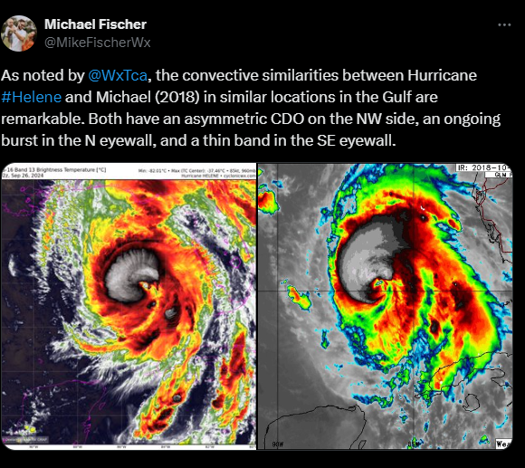
From Michael Fischer
-
Yeah. It has been a slow process for this storm, which, given its' size I am not necessarily shocked (though I did expect greater strengthening by this time). That withstanding, the latest Vortex Message showcases a Closed eye and it is getting itself gradually more and more together. I noticed last night that the outflow of this storm is quite impressive, both poleward and equatorward. In fact, what came to mind was a favorable trough interaction process with what is over the Midwest/SE United States currently. If that trough can truly vent Helene with the really warm bath water she currently sits in.. I shudder to think of what happens, especially given the core getting its act togehter, and despite being such a large storm. It, unfortunately, is a true wait and see game.
-
That is worrisome. As most know, an extra 6 or 12 hours over that bath water is going to have singificant implications for organization and intensity.
-
.jpeg.f97dbb93b2be004bd5f13dab8ba5988e.jpeg)
-
That western flank looks like trough interaction and outflow building to me. It looks pretty amazing from that perspective, imo
-
You can toggle through imagery here: https://www.star.nesdis.noaa.gov/GOES/conus_band.php?sat=G16&band=GEOCOLOR&length=24&dim=1 Edit: @wthrmn654 links are better.
-
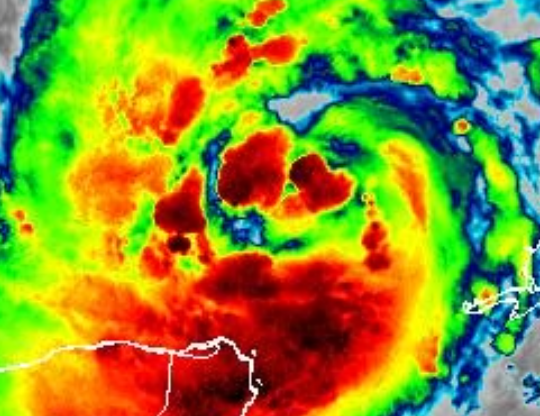
It may not be a ERC so much as the actual structuring of the eyewall finally coming together. Likewise, following ERCs (or the structuring finally being put together), hurricanes tend to take off. When these types of double bands develop and collapse to one, it tends to be a sign of health. Given the environment otherwise, it could be a rather ominous sign.
-
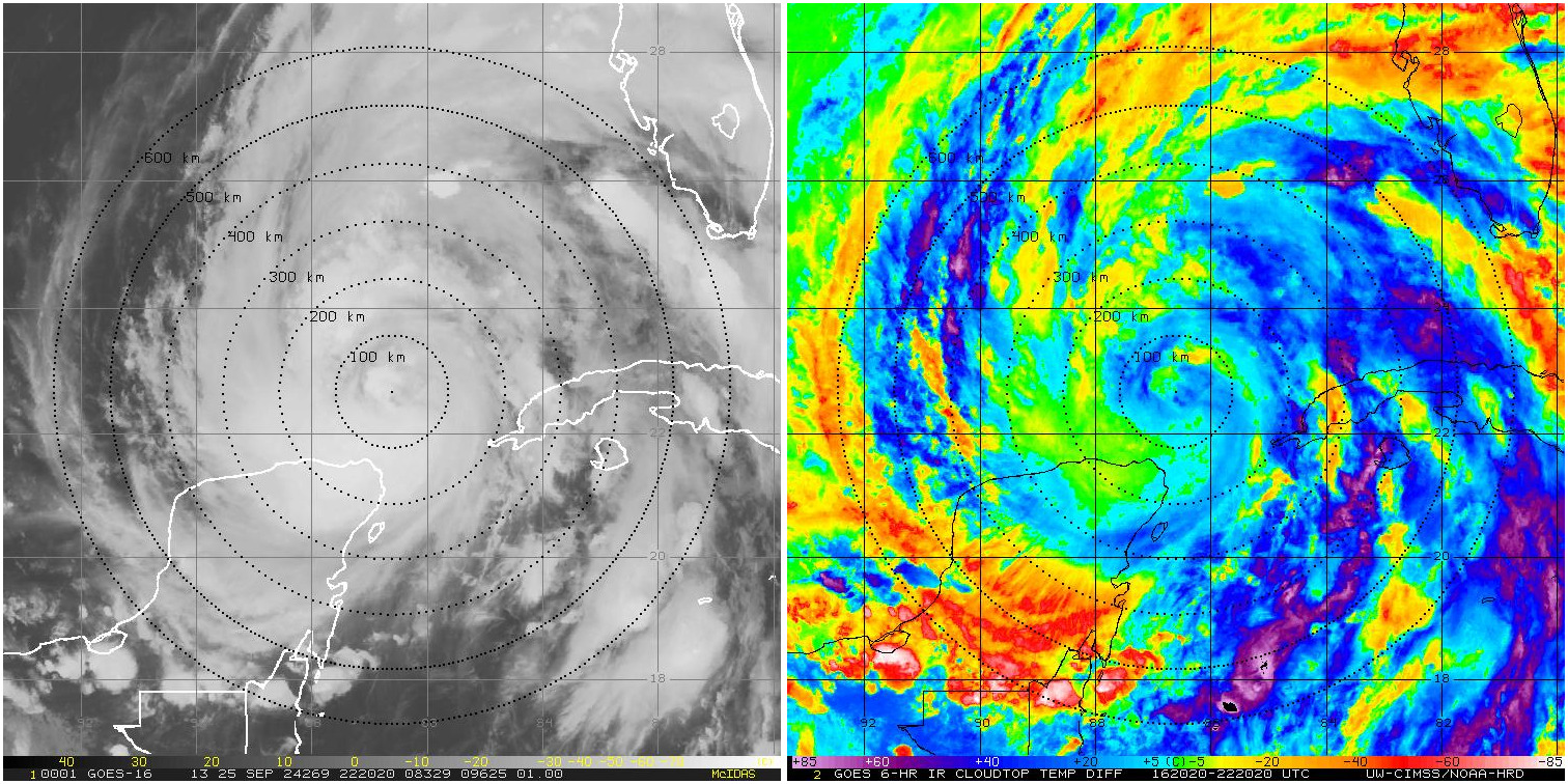
Based on this Satellite Picture, I would say that it is possible that these are Hot Towers showing up. That witsthanding, I would say they are not all that clearly defined as of yet, assuming they are. These hot towers, however, tend to indicate RI is beginning when observed. This is a pretty good and informative video on it: https://www.google.com/search?q=how+to+see+a+hot+tower+in+a+hurricane&oq=how+to+see+a+hot+tower+in+a+hurricane+&gs_lcrp=EgZjaHJvbWUyCQgAEEUYORigATIHCAEQIRigATIHCAIQIRigATIHCAMQIRigATIHCAQQIRigATIHCAUQIRirAjIHCAYQIRirAjIHCAcQIRirAtIBCDQ1MjZqMGo3qAIAsAIA&sourceid=chrome&ie=UTF-8#fpstate=ive&vld=cid:d8125e6a,vid:8U5puPnqMNo,st:0
-
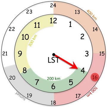
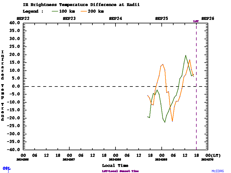
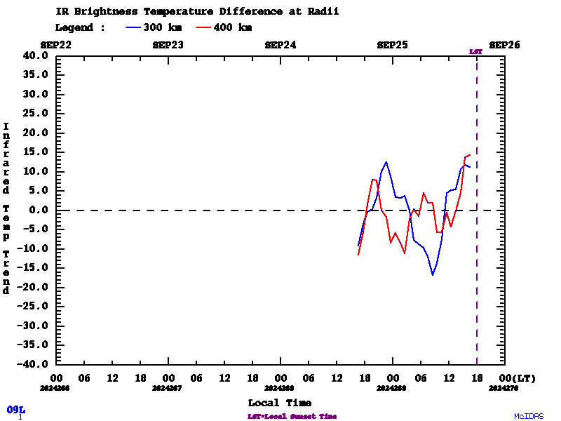
https://tropic.ssec.wisc.edu/real-time/tc_diurnal_cycle/tc_diurnal_cycle.storm.php?&period=3day&prod=&storm=09L This is pretty cool. Did some digging and found a paper on it. This is an expirament currently being run. Scientists have noticed that in the evening (at about sunset) a cold ring of high altitude clouds which propogate outwards overnight. There is a question as to how it affects the intesity of the Cyclone with a hyopthesis that these may indicate gravity waves as well as enhanced outflow in a particular layer of the Troposphere. It appears that this is just a coordination with aircraft hunters currently and a phenemenon which has been observed but as of yet, unknown as to why it is happening. https://www.aoml.noaa.gov/hrd/HFP2015/11-TC_Diurnal_exp.pdf