

USCG RS
-
Posts
3,010 -
Joined
-
Last visited
Content Type
Profiles
Blogs
Forums
American Weather
Media Demo
Store
Gallery
Everything posted by USCG RS
-

Refresher snow & obs between ~midnight and Noon Sat Feb 17 2024
USCG RS replied to wdrag's topic in New York City Metro
I agree. Between the snow cover in the area and the Wet bulb temps, I do not see much of an issue regarding accumulation. Now, NYC Roadways, of course are a different story absent moderate rates, but this is normal. -
Day 10, so I really don't want to say it, but I like the zero from a macro scale perspective. Granted it may be our last chance
-
2/13 Significant/Major Winter Storm Discussion & Observations
USCG RS replied to Northof78's topic in New York City Metro
@SnowGoose69 I feel like you would know this (for some reason): Why does CPK always measure so low? -
2/13 Significant/Major Winter Storm Discussion & Observations
USCG RS replied to Northof78's topic in New York City Metro
Wife and I went to Greenville, SC. Trust me, it ain't just Long Island. Or perhaps if everywhere I go there is a douchebag and I am there... Nah. -
2/13 Significant/Major Winter Storm Discussion & Observations
USCG RS replied to Northof78's topic in New York City Metro
Streaking with @MJO812 ? -
2/13 Significant/Major Winter Storm Discussion & Observations
USCG RS replied to Northof78's topic in New York City Metro
Which is honestly what my forecast is for the area and what I have been seeing for a day or two now. This is why I am concerned about area roadways. -
2/13 Significant/Major Winter Storm Discussion & Observations
USCG RS replied to Northof78's topic in New York City Metro
Well, flurries tomorrow it is. If ya know, ya know. Maybe this Sub Forum needs to pay for him to go on vacation in February more often... Unfortunately, without the rates, LI is in a very different spot. All depends on how quickly this deepens. Lack of blocking may be our detractor here after all, but, eh. February 2013 was a thread the needle and wound up phasing exactly where needed. Lets see. Edit - I still think NYC and LI get a hard hit. Dynamics all point towards this scenario.
-
2/13 Significant/Major Winter Storm Discussion & Observations
USCG RS replied to Northof78's topic in New York City Metro
I would agree with this. The key -IMO- is the phase. If it is cleaner and the storm explodes, then we have a game on system with a substantial hit for the Tri-State. IF it develops a bit late, then C/E LI have a moderate to significant hit and the rest of the Tri-State is a left behind. -
2/13 Significant/Major Winter Storm Discussion & Observations
USCG RS replied to Northof78's topic in New York City Metro
I personally still believe LI, NYC, S CT, CNJ take a hard hit here. Dynamically makes sense to me. However, there is always the potential this shifts further South. Given the downstream observations though, I would say this cannot correct too much further south. Some rather heavy rains and storms transversing the Carolinas. -
2/13 Significant/Major Winter Storm Discussion & Observations
USCG RS replied to Northof78's topic in New York City Metro
I agree, however, the Ukie and Euro tend to follow each other. Downstream observations show a significant amount of juice with this storm. I would not completely discount, but, I would also say just keep in mind and watch Short Rangers currently. If they begin to back up the Euro, then I would put true stock in it. -
2/13 Significant/Major Winter Storm Discussion & Observations
USCG RS replied to Northof78's topic in New York City Metro
Where the really heavy stuff sets up (of course this assuming the phase is clean and this explodes as some of the Short Rangers are alluding to), I would say the major highways are going to gunk up relatively quickly. If you have SN to SN-, then roadways are fine. But -and again this is an assumption which could bust- if the storm sets up in such a manner so as to dump some SN+, then roadways will quickly become rather nasty. This is why I was saying I would prepare as if you are going to take a hit, because to be caught off guard in something like that is not fun (IE, Feb 2013 - No I am not saying this is a Feb 2013 redux). -
2/13 Significant/Major Winter Storm Discussion & Observations
USCG RS replied to Northof78's topic in New York City Metro
My 2 Cents: Those in the fringe areas, treat this as if it will be a hit and take precautions, especially NYC, LI, NW and CNJ and SE CT on up through SE MA. This snowfall will be incredibly heavy where the axis sets up and you do not want to be caught off guard. This is the type of snow which creates traffic havoc and can lead to some of these horror stories you hear of when people are stuck for extended periods of times. Not saying it will be apocalyptic, but something to keep in mind and prepare for. -
2/13 Significant/Major Winter Storm Discussion & Observations
USCG RS replied to Northof78's topic in New York City Metro
While I agree with you regarding March/April and Nov, I would argue that this many times is the Sun Angel over anything else. I usually roll my eyes at Sun Angle arguments, however, here is where I believe the lack thereof of the Sun Angle plays a roll. As you know - during mid to late March and April as well as Nov, the Sun Angle burns considerable accumulation off the bat as it allows considerable more energy to reach the earth. (Neutrinos I believe) were shown by several studies to significantly increase in the times you mentioned, compared to winter months. These particles allow for significant energy transfer and thus snow rates must be much higher to overcome this energy transfer (and earths absorption) from the sun. During February, however, there is a considerable decline in this number of energized particles hitting the earth (compared to the aforementioned months/time periods). Therefore, I would argue that a snow storm with heavy rates in February will create quite the havoc throughout the Tri-State. Perhaps ratios take a hit, but this time of year - I would say the Tri-State is in for a rough time (travel wise). -
2/13 Significant/Major Winter Storm Discussion & Observations
USCG RS replied to Northof78's topic in New York City Metro
NYC and LI are going to get rocked. I know it's hard to believe.... But I firmly believe this is coming - and not just because I want it lol. -
2/13 Significant/Major Winter Storm Discussion & Observations
USCG RS replied to Northof78's topic in New York City Metro
Yes. This could quickly become a sticky situation. Those commuting need to keep this in mind. -
2/13 Significant/Major Winter Storm Discussion & Observations
USCG RS replied to Northof78's topic in New York City Metro
Bingo. -
2/13 Significant/Major Winter Storm Discussion & Observations
USCG RS replied to Northof78's topic in New York City Metro
Assuming this is correct (which I've provided my reasoning as to why I do believe it is), those in Long Island need to think about driving. This is going to be very heavy, wet snow where this thumps and winds look like we will be close to very poor visibility if not the sought out and belive B word. I would be cognizant of this and I would do my best not to drive during this storm if possible. Ala Feb 2013 vibes tbh. EDIT : No, I am not calling for 8+ inch an hr rates rn lol. -
2/13 Significant/Major Winter Storm Discussion & Observations
USCG RS replied to Northof78's topic in New York City Metro
Something to note here. Look at the dynamics in that simulated radar. A plethora of red and yellow, throughout nearly the entirety of the precip shield (even the blue has heavy simulated echos). Given those dynamics - and cold air filtering in - I would bring that Rn/Sn line south. Note - anyone just north of that transition line is gonna be pounded for a while. This is the type of snow that makes roads horrific. Something to keep in mind. (Yes I know it's the NAM 3k, but my point about the dynamics stands)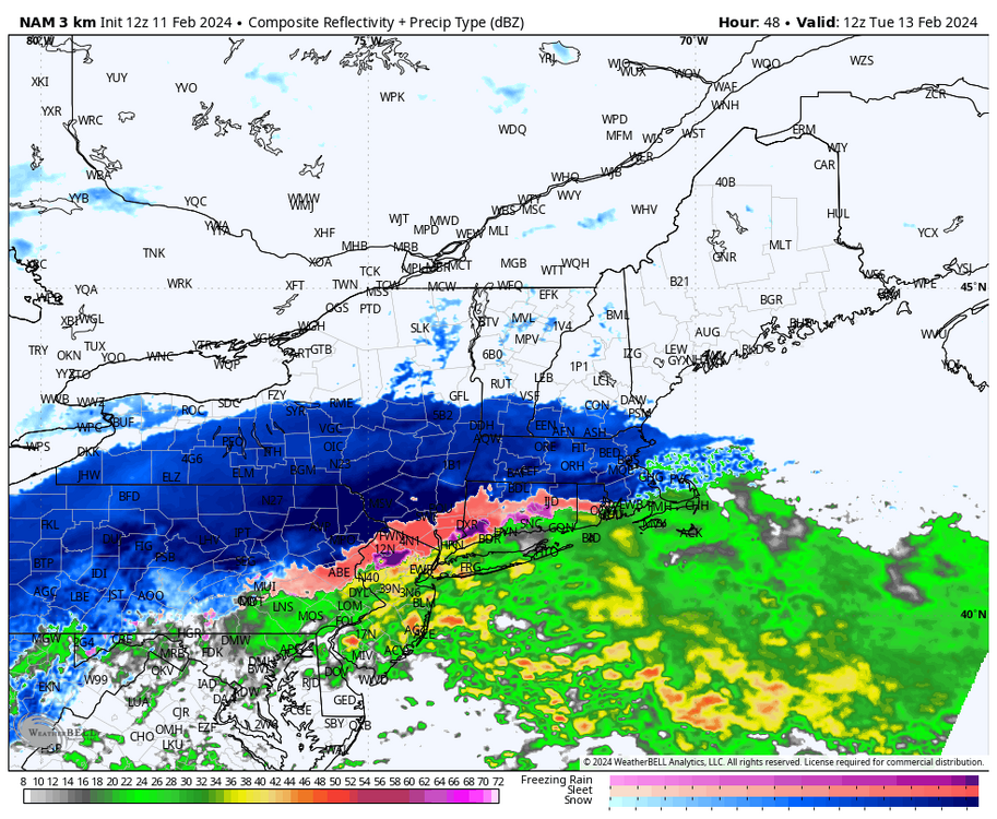
-
2/13 Significant/Major Winter Storm Discussion & Observations
USCG RS replied to Northof78's topic in New York City Metro
Given the Baroclynic Zone to set up, I would say this shifts south. You have cold air coming in, not retreating. Likewise, as a poster (MaineJay) on another board stated: "I'll go on a little limb here. The baroclinic zone appears about 20-40 miles south of what the NAM3 has it. I'm thinking that the NAMs tick south with the 12z." This has been my sentiment for a while (he just more beautifully stated it). That withstanding, given the cold air overriding the warm SSTs, I would say this shifts south. Likewise, the BCZ will allow for better dynamics as well. I would say NYC and LI, SCT as well are in a good spot for this. Thumpy. -
2/13 Significant/Major Winter Storm Discussion & Observations
USCG RS replied to Northof78's topic in New York City Metro
I still believe the confluence will win out here. That and the baroclynicity will push it south a bit. Where the confluence war sets up sets the stage for a good hard thump. -
2/13 Significant/Major Winter Storm Discussion & Observations
USCG RS replied to Northof78's topic in New York City Metro
We literally had a blizzard a few years back and the days leading up were in the 40-50s and the day before was 70+ on long Island. -
2/13 Significant/Major Winter Storm Discussion & Observations
USCG RS replied to Northof78's topic in New York City Metro
That much rain given the previously warm ground... I should be skeptical of those totals. Verbatim of course. February 2013 (Nemo) had this type of cutoff. I remember driving North on William Floyd and as I passed under the LIE, you could literally see the difference over a mile. It felt quite like lake effect snow. Oh the fun of being the literal transition zone. Those just north of that zone tend to do rather well. "You have to smell the rain." I do think Long Island could take a hard hit here, given the confluence pressing down and the avaliable moisture and energy combined. -
2/13 Significant/Major Winter Storm Discussion & Observations
USCG RS replied to Northof78's topic in New York City Metro
Yes -
2/13 Significant/Major Winter Storm Discussion & Observations
USCG RS replied to Northof78's topic in New York City Metro
GFS consistency does not mean it's correct. Seen that too many times -
2/13 Significant/Major Winter Storm Discussion & Observations
USCG RS replied to Northof78's topic in New York City Metro
There's another forum that needs your unicorn appearances...Just saying.


