WxWatcher007
-
Posts
36,051 -
Joined
-
Last visited
Content Type
Profiles
Blogs
Forums
American Weather
Media Demo
Store
Gallery
Everything posted by WxWatcher007
-
Yeah there's one piece that seemingly wants to be in place, but unless the ridge is rolling over into SE Canada it's going to be hard to block an escape if this tries heading our way. We'll see how much, if any, things change as we get recon/balloon data and see how Humberto affects things. Part of me is wondering if Humberto takes off intensity wise and gets poleward faster for its escape if that closes the door for a future Imelda escape. I mean the 12z Euro (we sell for now) does what it does because that ridge builds over the top and into SE Canada before Imelda can escape. I still think if anything this is a Carolinas threat or OTS but we have a long way to go.
-

Category Five Hurricane Humberto
WxWatcher007 replied to WxWatcher007's topic in Tropical Headquarters
Close to MH status by day 5. Tropical Storm Humberto Discussion Number 1 NWS National Hurricane Center Miami FL AL082025 500 PM AST Wed Sep 24 2025 Satellite data indicates that Invest 93L over the central tropical Atlantic has now developed into Tropical Storm Humberto. Visible satellite imagery shows that throughout the day, the low-level center has become well-defined, with persistent and organized deep convection mainly located over the eastern side of the system. Subjective Dvorak intensity estimates from TAFB and SAB were both data-T/2.5 35 kt. DPRINT and DMINT Objective intensity estimates from UW-CIMSS range from 31 to 35 kt. Using these data, the initial intensity is set to 35 kt. The system is estimated to be moving west-northwestward at 300/13 kt, but this is of low confidence since the center has only recently formed. A west-northwestward to northwestward motion is anticipated through the next several days along the southwestern periphery of a mid-latitude ridge. Towards the end of the forecast period, an approaching trough moving offshore the east coast of the United States will erode the ridge and allow the system to turn more northward. However, there is quite a bit of uncertainty with the forward speed and cross-track spread of the system. This is increasingly apparent beyond day 3 as there are complex steering components with timing differences in the global models, including the approaching trough and potential binary interaction with Invest 94L. The NHC track forecast lies near the consensus aids given some of these uncertainties, and there is lower than normal confidence in the track forecast. The storm is within a favorable environment for strengthening with warm sea surface temperatures near 29C and moist mid-level RH values. The system will be dealing with some moderate westerly wind shear for the next day or so that will likely cause an asymmetric storm structure. EC and GFS SHIPS guidance depict the shear slightly weakening in the day 2 to 4 time frame, and with increasing divergence aloft, a slightly greater rate of strengthening is shown at that time. The latest NHC forecast follows these trends and lies near the consensus intensity aids. FORECAST POSITIONS AND MAX WINDS INIT 24/2100Z 20.1N 54.9W 35 KT 40 MPH 12H 25/0600Z 20.9N 56.0W 40 KT 45 MPH 24H 25/1800Z 21.6N 57.0W 45 KT 50 MPH 36H 26/0600Z 22.0N 57.5W 50 KT 60 MPH 48H 26/1800Z 22.5N 58.2W 55 KT 65 MPH 60H 27/0600Z 22.9N 59.0W 60 KT 70 MPH 72H 27/1800Z 23.6N 60.6W 70 KT 80 MPH 96H 28/1800Z 26.0N 64.3W 90 KT 105 MPH 120H 29/1800Z 29.1N 67.1W 95 KT 110 MPH $$ Forecaster Kelly -
That’s happened to me several times already. They’ll have names soon enough. Imelda could’ve been retired the first time around. Second time’s the charm?
-
I may be wrong, but I don’t recall the NHC delivering key messages for an undesignated or non-PTC system.
-
Category Five Hurricane Humberto
WxWatcher007 replied to WxWatcher007's topic in Tropical Headquarters
Might be declared at 5pm with that LLC tucking under the convection on IR. -
That may be the only thing that saves the east coast…
-
Disagree. 93L is far enough east it would’ve always been caught in that weakness and shipped out. 94L is exactly the kind of system that could threaten the EC this year—weak and buried in the Bahamas before finding itself potentially captured by a cutoff or blocked by an over the top ridge. We should all be selling the ops but the ensembles have been clear this is something to watch for the east coast if not a bona fide threat, which I’m not ready to call yet. NOAA is taking it seriously—we’re already getting key messages and recon out there. Edit: usual caveats for New England—meh, this no chance here, don’t waste your time.
-
Although there’s not much in the way of low level center, there’s a pretty robust mid level reflection as evidenced by visible satellite and TJUA radar. Not sure I buy the 12z GFS evolution.
-
Category Five Hurricane Humberto
WxWatcher007 replied to WxWatcher007's topic in Tropical Headquarters
This one has a good shot of becoming our third consecutive major. It’s looking well on its way to being designated a TC in the next 24 hours. -
Who needs AC when it’s **checks Davis** 70.0° outside?
-
Are you sure?
-
This is a pretty wild setup. Everything is on the table. I can't recall two invests being this close to one another.
-
This year has been the biggest test of my annual peak season forecast. We're a long way from grading and spiking any footballs, but I'm pleased with my call of a dead period like last year lasting until around 9/20, and activity being focused in the SW Atlantic. A huge part of my forecast can be verified by what happens in the next week or so.
-
Recon might start sampling the environment today per NHC. This is a really complicated setup with the two systems so close. 00z EPS
-
Eastern Caribbean Sea (AL94): A tropical wave over the northeastern Caribbean Sea is producing disorganized showers and thunderstorms. This wave is expected to move west-northwestward at 15 to 20 mph, spreading heavy rainfall and gusty winds into Puerto Rico and the Virgin Islands today, and across the Dominican Republic beginning tonight. The system is then expected to slow down and turn northwestward when it reaches the southwestern Atlantic late this week. Environmental conditions are forecast to be more conducive for development in a few days, and a tropical depression is likely to form when the disturbance is in the vicinity of the Bahamas. Interests in the Virgin Islands, Puerto Rico, the Dominican Republic, the Turks and Caicos Islands, and the Bahamas should monitor the progress of this system. An Air Force Hurricane Hunter Aircraft is scheduled to perform a system survey this afternoon to gather data from the surrounding environment, if necessary. * Formation chance through 48 hours...low...30 percent. * Formation chance through 7 days...high...80 percent.
-
Category Five Hurricane Humberto
WxWatcher007 replied to WxWatcher007's topic in Tropical Headquarters
Good chance this becomes a TD later today or tonight. Despite westerly shear the organizational trend continues. -
2025 Atlantic Hurricane Season
WxWatcher007 replied to BarryStantonGBP's topic in Tropical Headquarters
With a trough possibly in SE Canada at the time of closest approach no direct hit is definitely on the table. -
2025 Atlantic Hurricane Season
WxWatcher007 replied to BarryStantonGBP's topic in Tropical Headquarters
I think we need to see how the next few weeks play out, but definitely true that most missed the early September peak of the season being historically dead. -
.88” in 30 minutes
-
Good lightning with this storm.
-
I still think it's too early to get a great sense for anything in the US. This is a really complicated steering pattern, in large part driven by the proximity of 93L and 94L. Folks along the coast should definitely pay attention to this one, though there's no real need for concern yet. The Euro trend toward a strong 94L is interesting though. That's definitely something to watch.
-
2025 Atlantic Hurricane Season
WxWatcher007 replied to BarryStantonGBP's topic in Tropical Headquarters
Maybe but what's a bust to you? -
Back at WXW1 and it's downright tropical
-
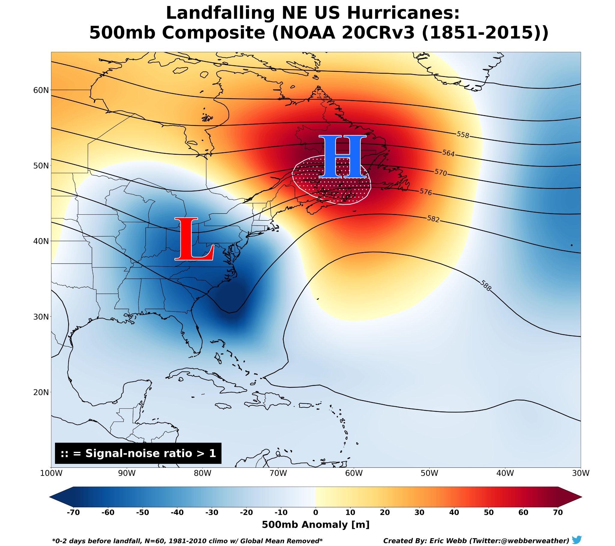
I mean, the first thing when discussing New England tropical is caveating it to death about how hard it is to get legit tropical up this way. Now that that's out of the way, if we're talking about strictly a NE landfall I agree with @FXWX, the overall setup does not lend itself to a Long Island Express scenario. Not even close. Here's what the general NE landfall steering pattern looks like: And here are the latest 500mb depictions of the EPS and GEFS for Monday at 12z: The GFS/GEFS originally led the way in highlighting the possibility of TC genesis, but has seemed to be way off with trying to consolidate 93L and 94L off the southeast coast. That has its own implications but just look at the 500h vs the usual NE setup. Yeah, there's a cutoff in the southeast, but the ridge is too far west and that opens an escape hatch to the east even if this landfalls further south. The EPS is a little more interesting to me but you can see the same issue. The cutoff and ridge over the top brings a potential US threat, but its further south, again because the ridge is too far west and that opens the escape hatch to the east. Here's 18z Euro operational: Even with a highly anomalous potential interaction off the SE coast with two hurricanes, you have the same issue, though the UL cutoff is still around and there is a strong Atlantic ridge (that would likely still lead to an escape hatch with that NW flow in SE Canada). What you'd need for a coastal runner imo is either 1) the ridge quickly translating east over SE Canada, thereby blocking the escape hatch or 2) a stronger and further north cutoff that can capture and pull whatever is out there into the coast (though even there you risk a close miss rather than a direct strike). This is very different further south, especially in the Carolinas if this is buried in the Bahamas and there's a cutoff to the west. So while this could very well be a SE or even Mid-Atlantic threat, right now a direct NE hit looks least likely. With so many moving pieces however and the trends that we could see either way with the amplitude and orientation of the ridges/troughs, I do think this is worth watching. Whether it is worth more attention here than anything we've had sense Henri or Isaias remains to be seen. This does look like a rare scenario where both invests develop despite their proximity.

-
This is quite the setup moving forward. Really need to see how 94L interacts with Hispaniola. 93L is on its way to development imo.