WxWatcher007
-
Posts
35,736 -
Joined
-
Last visited
Content Type
Profiles
Blogs
Forums
American Weather
Media Demo
Store
Gallery
Everything posted by WxWatcher007
-
It’s filling in pretty good now for Kev and I. Temps responding as a result.
-
Nasty band just over the border in NY.
-
This is it right here, boys. Gotta produce. Temp has been ticking nicely here with the dew down to 32.
-
Temp down to 34 here. Hoping we can get this radar to light up and dump over central and eastern areas. It’s looking decent so far as 700 moves east.
-
Me either, but the triangle of dry slotting needs hope.
-
I hacked into his feed to get me close to warning level accumulation too
-
Back to snow, and the temp is gradually dropping. Have to hope the Euro has a bit of a clue—it’s pretty aggressive here later. 35.4/34 T 1.87”
-
All we can do is hope everyone else maximizes today.
-
Thanks. Hope it’s right but by the time it cranks (if at all) my temps are probably going to be an issue. Western CT looks primed. Will get ugly out there today.
-
And dry slot over me and Kev. You hate to see it.
-
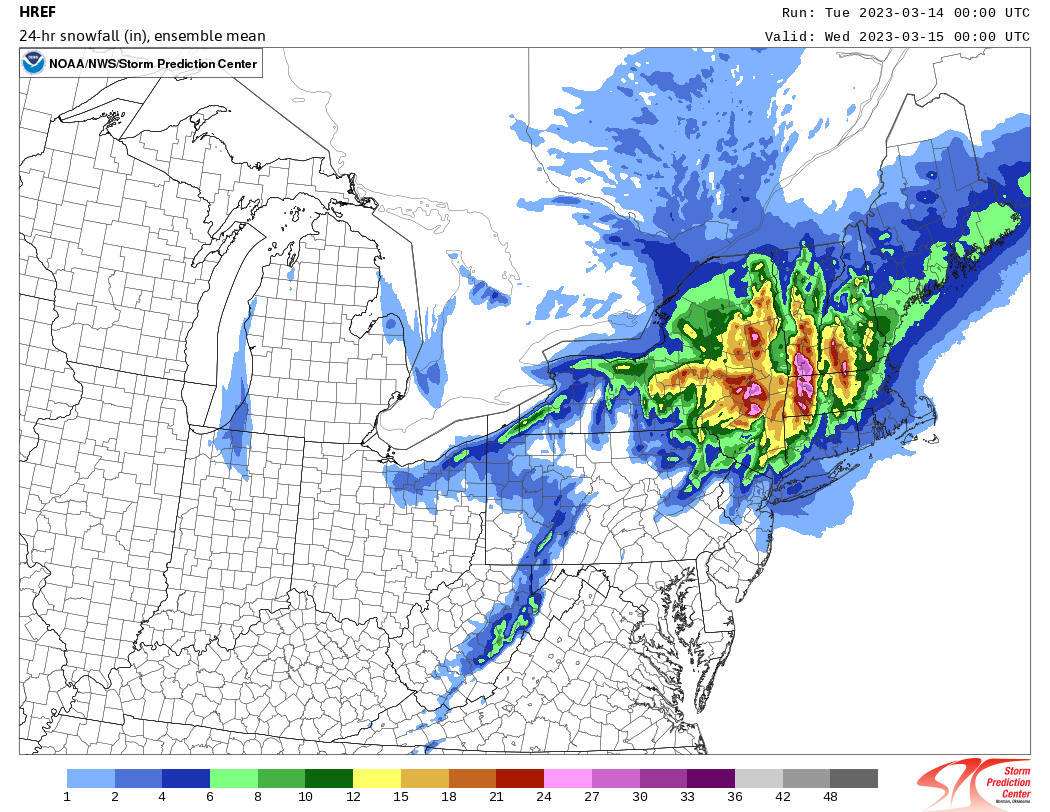
This is nuts. 20.5 in Windsor, MA? Nearing a foot in NW CT.
-
Well, I just went from 0.0 to a T. We still have a long way to go here. If we slot later this morning/afternoon it’ll be hard to get accumulations here as Scooter said earlier. You’re probably good.
-
33.5/32 Light snow
-
1.71” of rain so far. 33.7/32 I don’t need to see anything else. Excuse my language, but I’m fucked here. First time I’ve typed that since being on the forum. Congrats to everyone else getting a good storm today. Keep the pics coming and I sincerely hope as many cash in as possible.
-
-
I expect 0.0 here too but I am a little angry that this fell apart in the fashion it looks to have. We’ll see what the day brings, but this is easily the worst season I’ve ever seen imby subjectively. That said, hoping for a miracle.
-
Good to see the CC drop here. Still heavy rain.
-

The last hurrah? Putting all the eggs in the Tuesday 3/14 basket
WxWatcher007 replied to Ginx snewx's topic in New England
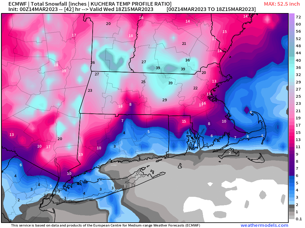
Not sure why my map is different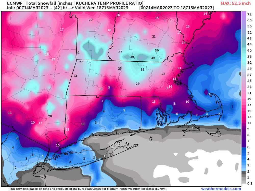
-
The last hurrah? Putting all the eggs in the Tuesday 3/14 basket
WxWatcher007 replied to Ginx snewx's topic in New England
Yeah, that ends at 00z. At this point I’d sign for that and just move on. I’m expecting no accumulation here now. Feel like I need a Hail Mary. Absolutely pouring here. -
The last hurrah? Putting all the eggs in the Tuesday 3/14 basket
WxWatcher007 replied to Ginx snewx's topic in New England
Good luck out there. It looks good on the guidance. Could be a high end period if things break right. -
The last hurrah? Putting all the eggs in the Tuesday 3/14 basket
WxWatcher007 replied to Ginx snewx's topic in New England
My only hope at this point. Pretty bullish for W CT and solid for E Mass.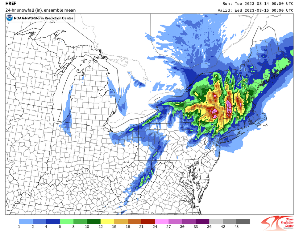
-
The last hurrah? Putting all the eggs in the Tuesday 3/14 basket
WxWatcher007 replied to Ginx snewx's topic in New England
Mesoscale Discussion 0287 NWS Storm Prediction Center Norman OK 1154 PM CDT Mon Mar 13 2023 Areas affected...Hudson Valley region into parts of southern New England Concerning...Heavy snow Valid 140454Z - 141030Z SUMMARY...Heavy wet snow will increase overnight, with 1-2 inch per hour rates possible, especially at higher elevations. DISCUSSION...At 0430Z, an intensifying cyclone is evident in WV/IR imagery well off of the Mid Atlantic coast (near 37N, 71W). A surface trough extends northwest of this cyclone, with an apparent mesolow (suggested by radar imagery and surface/ship/buoy observations) moving north-northeastward along the surface trough toward western/central Long Island, where the strongest 2-hour pressure falls are currently noted. Meanwhile, a strong mid/upper-level shortwave trough is moving eastward out of the OH Valley region toward the Northeast/New England. Increasing deep-layer ascent associated with the approaching shortwave trough combined with persistent low-level moisture transport will intensify precipitation rates overnight from the Hudson Valley region into parts of southern New England. Temperatures remain near/above freezing across the region as of 04Z, though higher elevations and portions of the Hudson Valley have turned over to snow. For western MA/northwest CT/southern VT into adjacent portions of the Hudson Valley, limited near-surface warm advection along/west of the surface trough will allow precipitation type to remain as snow overnight, resulting in the potential for 1-2 inch per hour snow rates as precipitation intensifies. Farther east, stronger low-level warm advection results in some uncertainty regarding precipitation type at lower elevations, though very heavy wet snow rates will be possible at higher elevations in the Worcester Hills and vicinity overnight. -
Heavy heavy rain. Shadowing never an issue when it’s liquid. 36/34
-
The last hurrah? Putting all the eggs in the Tuesday 3/14 basket
WxWatcher007 replied to Ginx snewx's topic in New England
Canadian looked great the last few days too.