WxWatcher007
-
Posts
35,670 -
Joined
-
Last visited
Content Type
Profiles
Blogs
Forums
American Weather
Media Demo
Store
Gallery
Everything posted by WxWatcher007
-
It’s insanely hard, and deeply frustrating as a result. Between the trees, local road network, and interstate traffic, it’s awful. I’ve been able to get ahead of some in the past by doing what you mentioned, but that’s the exception to the rule. Had these storms developed west, I would have had a couple of good viewing spots nearby. Oh well. I’m just bored.
-
Very frustrated. Tried to chase the cell that popped just to my south because it looked promising, but could never get where I needed to be. My area just sucks for anything interesting. It is what it is.
-
Blows. Absolutely blows.
-
Nice looking cell right by @Sey-Mour Snow
-
Cloud cover from the missed storms taking down my temp lol. High of 93.3 today.
-
-
Torching now. 90.5°
-
Not a bad series of cells up there. Probably quite a bit of rain too with some training going on.
-
Nothing spectacular but 38k ft top on that cell near Blandford, MA.
-
I just want to see a good storm
-
86.5° here at noon.
-
Running six degrees ahead of yesterday’s temperature at this part of the day.
-
High of 89.4° here today.
-
TD Two at 5pm
-
I think we have enough.
-

Tropical Storm Arlene—40mph/998mb
WxWatcher007 replied to WxWatcher007's topic in Tropical Headquarters
Agree. Thought we’d see a more well-defined circulation but this is pretty close to a tropical cyclone if it’s not there already. -
More TS winds in the newest data. Just need to find a well-defined LLC now IMO.
-
Some tropical storm winds at flight level and via SFMR on the latest batch of data from recon.
-
Tropical Storm Arlene—40mph/998mb
WxWatcher007 replied to WxWatcher007's topic in Tropical Headquarters
Recon descending into 91L now. -
Recon descending into 91L now. You can tell via visible satellite that dry air is nearby, but the circulation does look better defined at least at the mid level.
-
Tropical Storm Arlene—40mph/998mb
WxWatcher007 replied to WxWatcher007's topic in Tropical Headquarters
Posting text as well Tropical Weather Outlook NWS National Hurricane Center Miami FL 200 PM EDT Thu Jun 1 2023 For the North Atlantic...Caribbean Sea and the Gulf of Mexico: 1. Northeastern Gulf of Mexico (AL91): Recent satellite wind data, along with buoy and ship observations indicate the area of low pressure over the northeastern Gulf of Mexico has a broad but well-defined circulation with maximum sustained winds of about 35 mph. Shower and thunderstorm activity associated with the low is also showing signs of organization. Environmental conditions remain marginally favorable for additional development, and if these trends continue, a short-lived tropical depression or storm is likely to form as soon as this afternoon. The system is likely to meander over the northeastern Gulf of Mexico through tonight but begin a slow southward motion on Friday. By this weekend, environmental conditions are forecast to become unfavorable for additional development as the system continues moving southward, likely remaining offshore over the Gulf of Mexico. An Air Force Reserve Hurricane Hunter aircraft is scheduled to investigate the system later this afternoon. Regardless of development, locally heavy rainfall could occur over portions of the Florida Peninsula through this weekend. Additional information on the rainfall and flooding potential can be found in products issued by your local National Weather Service forecast office and Excessive Rainfall Outlooks issued by the Weather Prediction Center. * Formation chance through 48 hours...high...70 percent. * Formation chance through 7 days...high...70 percent. Forecaster Papin/Cangialosi -
Up to 70% odds now with the first recon mission of the year about to begin.
-
Barely any shear on the soundings lol
-
What are you thinking about tomorrow here?
-
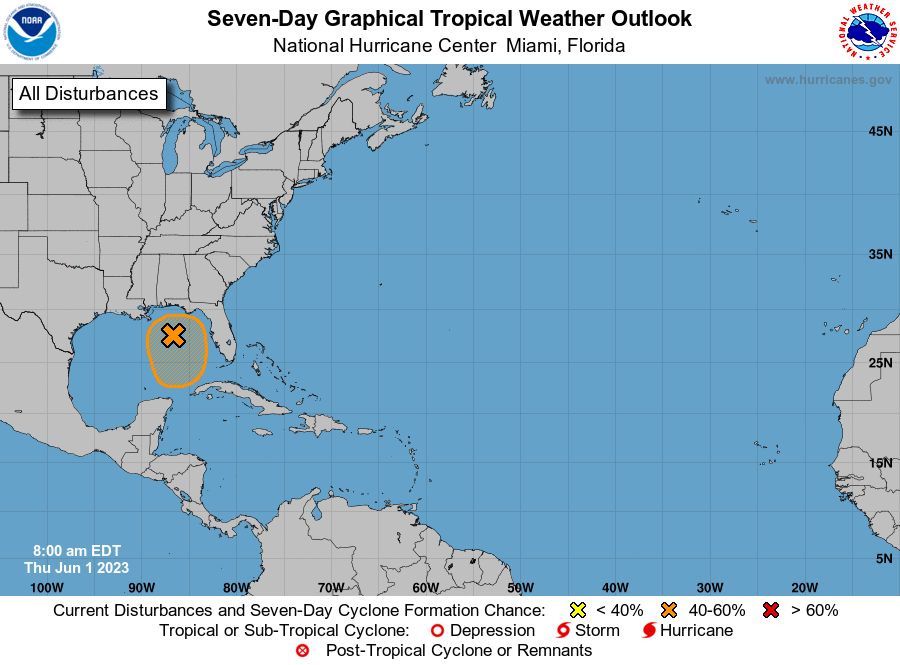
The 2023 Atlantic hurricane season has arrived, and we have our first orange of the season in Invest 91L. Overnight we saw a little more organization, with pressure falls and persistent convection near a center of circulation. This led to the odds of development being raised this morning by the NHC. Satellite and radar still show that there are headwinds for tropical cyclone genesis, as westerly shear has convection lopsided on the eastern side of the system. It should be noted that it's June 1st lol, so most tropical this time of year is near the coast and often "slop". That said, recon is scheduled for today and tomorrow, the real window of development before the conditions become much more unfavorable. For those that are new to the tropical subforum--we use these threads to separate discussion for distinct areas of interests and named systems. Tropical Weather Outlook NWS National Hurricane Center Miami FL 800 AM EDT Thu Jun 1 2023 For the North Atlantic...Caribbean Sea and the Gulf of Mexico: 1. Northeastern Gulf of Mexico (AL91): Showers and thunderstorms associated with an area of low pressure over the northeastern Gulf of Mexico have increased and become better organized during the overnight hours. Environmental conditions appear marginally favorable for additional development over the next day or so, and a short-lived tropical depression or storm could form over that time span as the system meanders over the northeastern Gulf of Mexico. However, by this weekend environmental conditions are forecast to become unfavorable for additional development as the system drifts southward, likely remaining offshore over the Gulf of Mexico. An Air Force Reserve Hurricane Hunter aircraft is scheduled to investigate the system later today, if necessary. Regardless of development, locally heavy rainfall could occur over portions of the Florida Peninsula through this weekend. Additional information on the rainfall and flooding potential can be found in products issued by your local National Weather Service forecast office and Excessive Rainfall Outlooks issued by the Weather Prediction Center. * Formation chance through 48 hours...medium...50 percent. * Formation chance through 7 days...medium...50 percent. Today marks the first day of the Atlantic hurricane season, which will run until November 30. The long-term averages for the number of named storms, hurricanes, and major hurricanes are 14, 7, and 3, respectively. The list of names for 2023 is as follows: Name Pronunciation Name Pronunciation -------------------------------------------------------------------- -- Arlene ar-LEEN Lee lee Bret bret Margot MAR-go Cindy SIN-dee Nigel NY-juhl Don dahn Ophelia o-FEEL-ya Emily EH-mih-lee Philippe fee-LEEP Franklin FRANK-lin Rina REE-nuh Gert ger Sean shawn Harold HAIR-uld Tammy TAM-ee Idalia ee-DAL-ya Vince vinss Jose ho-Zay Whitney WHIT-nee Katia KAH-tya This product, the Tropical Weather Outlook, briefly describes significant areas of disturbed weather and their potential for tropical cyclone formation during the next seven days. The issuance times of this product are 2 AM, 8 AM, 2 PM, and 8 PM EDT. After the change to standard time in November, the issuance times are 1 AM, 7 AM, 1 PM, and 7 PM EST. A Special Tropical Weather Outlook will be issued to provide updates, as necessary, in between the regularly scheduled issuances of the Tropical Weather Outlook. Special Tropical Weather Outlooks will be issued under the same WMO and AWIPS headers as the regular Tropical Weather Outlooks. A standard package of products, consisting of the tropical cyclone public advisory, the forecast/advisory, the cyclone discussion, and a wind speed probability product, is issued every six hours for all ongoing tropical cyclones. In addition, a special advisory package may be issued at any time to advise of significant unexpected changes or to modify watches or warnings. NHC has the option to issue advisories, watches, and warnings for disturbances that are not yet a tropical cyclone, but which pose the threat of bringing tropical storm or hurricane conditions to land areas within 48 hours. For these land-threatening "potential tropical cyclones", NHC will issue the full suite of advisory and watch/warning products. Potential tropical cyclones share the naming conventions currently in place for tropical depressions, being numbered from a single list (e.g., "One", "Two", "Three", etc.). The Tropical Cyclone Update is a brief statement to inform of significant changes in a tropical cyclone, to post or cancel watches or warnings, or to provide hourly position updates between intermediate advisories when the storm center is easily followed by radar. It is used in lieu of or to precede the issuance of a special advisory package. Tropical Cyclone Updates, which can be issued at any time, can be found under WMO header WTNT61-65 KNHC, and under AWIPS header MIATCUAT1-5. All NHC text and graphical products are available on the web at https://www.hurricanes.gov. More information on NHC text and graphical products can be found at https://www.nhc.noaa.gov/pdf/NHC_Product_Description.pdf. New and updated products for the 2023 season can be found at https://www.nhc.noaa.gov/pdf/NHC_New_Products_Updates_2023.pdf. You can also interact with NHC on Facebook at https://www.facebook.com/NWSNHC. Notifications are available via Twitter when select National Hurricane Center products are issued. Information about our Atlantic Twitter feed (@NHC_Atlantic) is available at https://www.hurricanes.gov/twitter.php. Forecaster Papin/Cangialosi/Brown