WxWatcher007
-
Posts
36,088 -
Joined
-
Last visited
Content Type
Profiles
Blogs
Forums
American Weather
Media Demo
Store
Gallery
Everything posted by WxWatcher007
-
 Not sure why they took down that warning SW of Westminster
 -
Pack is done here. That ends a streak going back to Thanksgiving Day of continuous snow cover.
-
Warmer here at WXW2 than back in CT. Don’t see that often. Lake Placid mesonet gusted to 66mph last night. Nothing as exotic at SLK.
-
No such thing as a slam dunk in our neck of the woods. Will be interesting to see what today brings. It’ll be a fascinating meteorological evolution. Chasers—ALWAYS have multiple escape routes, and don’t hesitate to bail if you feel like something’s not right. Be safe, everyone.
- 1,093 replies
-
- 1
-

-
- severe
- thunderstorms
- (and 1 more)
-
This is nuts
-
Euro is pretty wet. 18z Nammy should be fun HREF
-
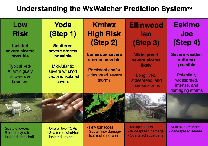
A representative from every preceding rung must be on board to go to the next step. I know Ian and Ellinwood aren’t around as much now so it may be time to update the system—just like the SPC. It’s just worked so beautifully for the last what, decade?
- 1,093 replies
-
- 1
-

-
- severe
- thunderstorms
- (and 1 more)
-
Doing better here right now—fits the nighttime fluff theme I’ve noticed my first year here. Edit: up to 2.5” storm total so far.
-
2026 Mid-Atlantic Severe Storm General Discussion
WxWatcher007 replied to Kmlwx's topic in Mid Atlantic
This one…has legs?- 1,705 replies
-
- 1
-

-
- severe
- thunderstorms
- (and 7 more)
-
HWW issued up here with gusts up to 60mph possible Monday.
-
Not much out this way. An inch with the March sun doing its work on daytime accumulation. Congrats.
-
Light snow up here at WXW2. Pack almost gone in my snow depth area.
-
Richmond Metro/Hampton Roads Area Discussion
WxWatcher007 replied to RIC Airport's topic in Mid Atlantic
Incredible! -
DCA was around 77° at midnight and now they have measurable snow. RIC with SN+ lol
-
Richmond Metro/Hampton Roads Area Discussion
WxWatcher007 replied to RIC Airport's topic in Mid Atlantic
Congrats. This is awesome to see. What was the RIC high yesterday? -
We ping. 38.4°
-
75.8 and still going...
-
Not done yet, but the writing is on the wall. 75 not out of the question here today. 60 on the table up at WXW2.
-
Last year I fired up the annual thread on March 8. After a continuous period of snow cover for the last seven weeks and two days, my CT pack finally gave up the ghost yesterday on our first 70 degree day since October 19. With respect to those still tracking wintry chances (myself included), it's time to fire up the thread. This was my first year since returning to CT in 2018 with the following: 1) A normal snowfall winter 2) Over 50" of snowfall 3) Several below zero low days 4) DJF all below normal avg temperature 5) Maximum snow depth over 12" for an extended period 6) Maximum snow depth of over 18" 7) No major cutters in DJF 8) NYD snow 9) Two 12"+ Events 10) An entire winter month with snow cover I also spent most of my first winter up at my new place in Saranac Lake. We're in striking distance of 150" on the season there, with continuous snow cover since November 27 and measurable snow falling on Halloween, Thanksgiving, Christmas Eve, Christmas Day, New Year's Eve, and New Year's Day. Maximum low of -20.2 and nearly 36 hours of below zero temperatures during a cold blast. Don't need to do much thinking about this winter. In CT it is an A. The combination of cold, snow, high end events, and snow cover is some of the best I've seen, even going back to my childhood in CT. Some potential left on the table, but we didn't get porked too badly. In SLK I mean my God. If we can do better than 2025-26...A+ The Big Dogs CT SLK
-
Does the wolf have Rabies? Unacceptable!
-
Pack almost gone
-
Never had a chance here. Plain plain rain.
-
I’m inclined to think we end up with a strong to very strong Nino, but the predictability barrier is real. It’s still early.