WxWatcher007
-
Posts
36,051 -
Joined
-
Last visited
Content Type
Profiles
Blogs
Forums
American Weather
Media Demo
Store
Gallery
Everything posted by WxWatcher007
-
HFD just gusted to 55
-
Wind producing now down in the DC area.
-
 Tornado Warning National Weather Service Baltimore MD/Washington DC 949 PM EDT Mon Mar 16 2026 The National Weather Service in Sterling Virginia has issued a * Tornado Warning for... Central Calvert County in southern Maryland... * Until 1000 PM EDT. * At 949 PM EDT, a severe thunderstorm capable of producing a tornado was located near Breezy Point, moving northeast at 75 mph. HAZARD...Tornado. SOURCE...Radar indicated rotation. IMPACT...For those in the direct path of a tornado touchdown, flying debris will be dangerous to those caught without shelter. Damage to roofs, siding, and windows may occur. Mobile homes may be damaged or destroyed. Tree damage is likely. * This tornadic thunderstorm will remain over mainly rural areas of central Calvert County, including the following locations... Huntingtown and Dares Beach.
- 1,093 replies
-
- 2
-

-
- severe
- thunderstorms
- (and 1 more)
-
Max gust?
-
Not sure. Didn't see anything other than the thread I shared.
-
In case folks haven’t seen:
-
I’m not sure it’s routine for this long in SLK (especially starting that early) but even in EH the length of snow cover was impressive. It’s been a great winter.
-
Meanwhile in Alabama
-
Yeah seemed odd given the radar presentation but it’s since weakened.
-
Not sure why they took down that warning SW of Westminster
-
Pack is done here. That ends a streak going back to Thanksgiving Day of continuous snow cover.
-
Warmer here at WXW2 than back in CT. Don’t see that often. Lake Placid mesonet gusted to 66mph last night. Nothing as exotic at SLK.
-
No such thing as a slam dunk in our neck of the woods. Will be interesting to see what today brings. It’ll be a fascinating meteorological evolution. Chasers—ALWAYS have multiple escape routes, and don’t hesitate to bail if you feel like something’s not right. Be safe, everyone.
- 1,093 replies
-
- 1
-

-
- severe
- thunderstorms
- (and 1 more)
-
This is nuts
-
Euro is pretty wet. 18z Nammy should be fun HREF
-
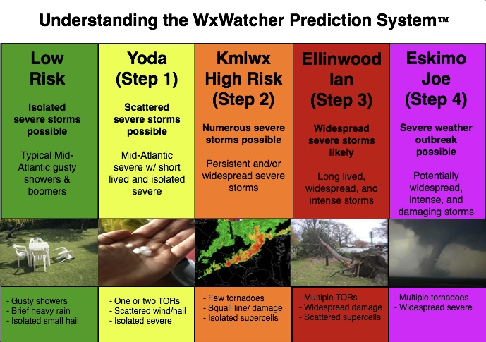
A representative from every preceding rung must be on board to go to the next step. I know Ian and Ellinwood aren’t around as much now so it may be time to update the system—just like the SPC. It’s just worked so beautifully for the last what, decade?
- 1,093 replies
-
- 1
-

-
- severe
- thunderstorms
- (and 1 more)
-
Doing better here right now—fits the nighttime fluff theme I’ve noticed my first year here. Edit: up to 2.5” storm total so far.
-
2026 Mid-Atlantic Severe Storm General Discussion
WxWatcher007 replied to Kmlwx's topic in Mid Atlantic
This one…has legs?- 1,455 replies
-
- 1
-

-
- severe
- thunderstorms
- (and 7 more)
-
HWW issued up here with gusts up to 60mph possible Monday.