

bristolri_wx
-
Posts
1,477 -
Joined
-
Last visited
Content Type
Profiles
Blogs
Forums
American Weather
Media Demo
Store
Gallery
Posts posted by bristolri_wx
-
-
Just curious, did this run of the NAM have the recon data?
-
 1
1
-
-
Just now, MuddyWx said:
anyone know how they assimilate this collected data so that it's available for models? like when would models ingest/use this new data?
Usually it's the next model runs after all the data is ingested.
-
2 minutes ago, CoastalWx said:
Seems like a bit of a waste of resources, but I don’t write the checks.
They probably have just as much interest as we do as to why the models can't figure this one out in a more agreeable way. Perhaps extra data can assist... The storm is going to be affecting several million people in some way.
-
1
-
 1
1
-
-
Forecasting weather is not my day job, so with that caveat, it's definitely interesting to see a storm that's actually starting where the models can't come to a consensus on a 12-36 hour snowfall forecast. Amazing.
-
It's looking like the coastal plain is kinda cooked on this one. My expectation will be for a surprise if we get some snow as the storm moves east rather than disappointment in not getting the snow others are receiving. Not surprising considering it's mid-March and there's really not much arctic air around.
-
Just now, TalcottWx said:
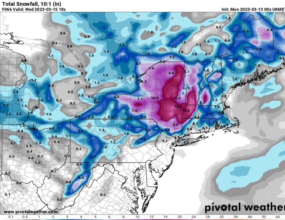
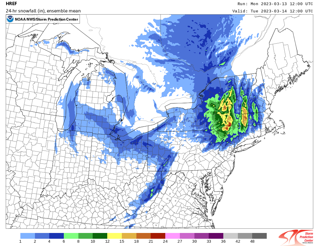
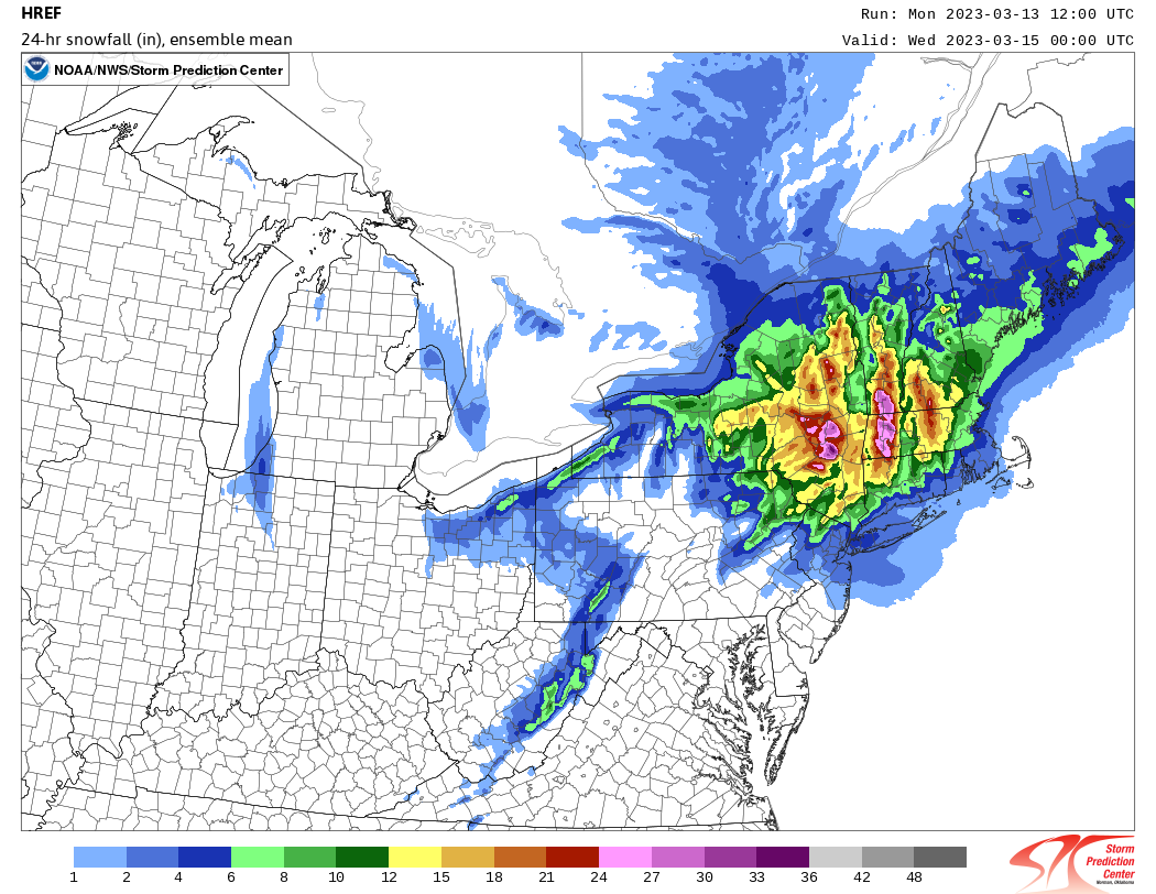
Whats the diff between those 2 snowfall maps? Is one kuchie?
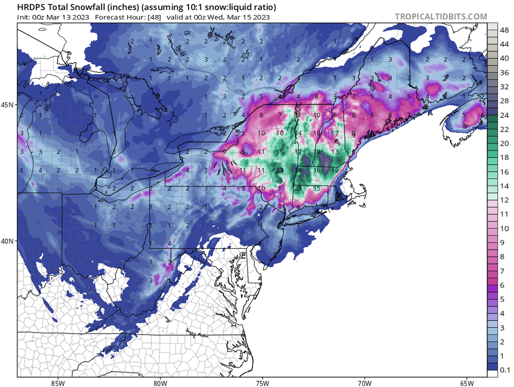
It's in 24 hour increments. They don't have total snowfall maps for HREF, at least not for the price I want to pay ($0). First map is 12z Mon to 12x Tue, the second is 12z Tue to 12Z Wed.
-
You can see why the bust potential in both directions exists. It's warmth vs rates. Probably anywhere in the coastal plain that's close to freezing and gets under a heavy band risks switching over to very heavy wet snow as it brings the cold down to the surface. And at the same time, the warmth could win out and that's just all heavy rain. Challenging forecast!
-
2
-
-
-
-
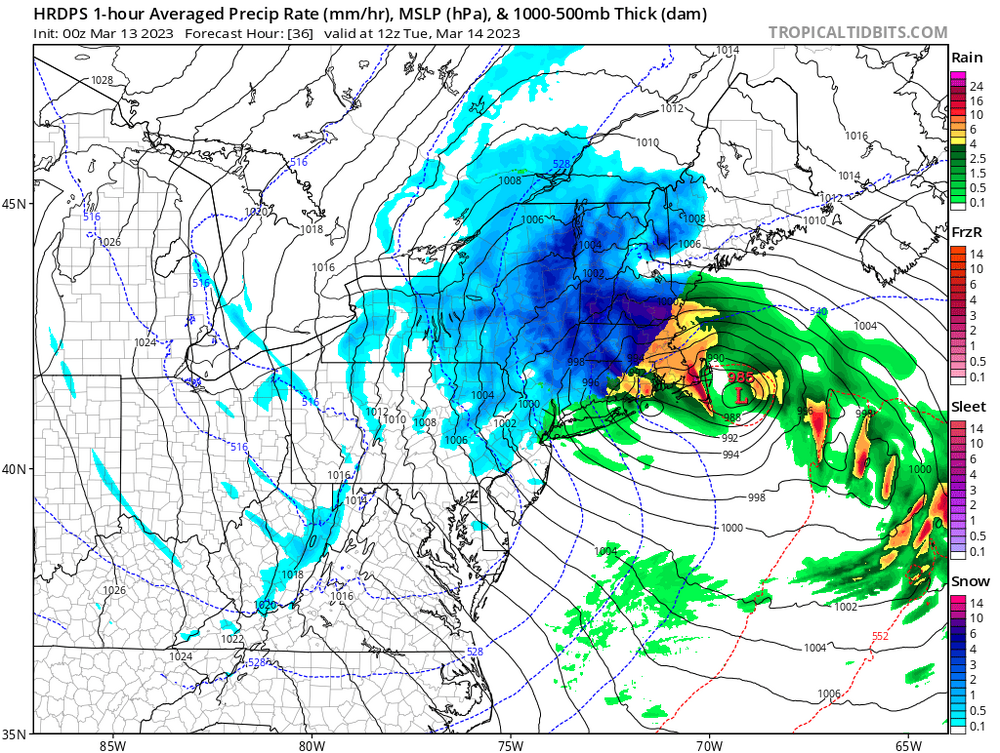
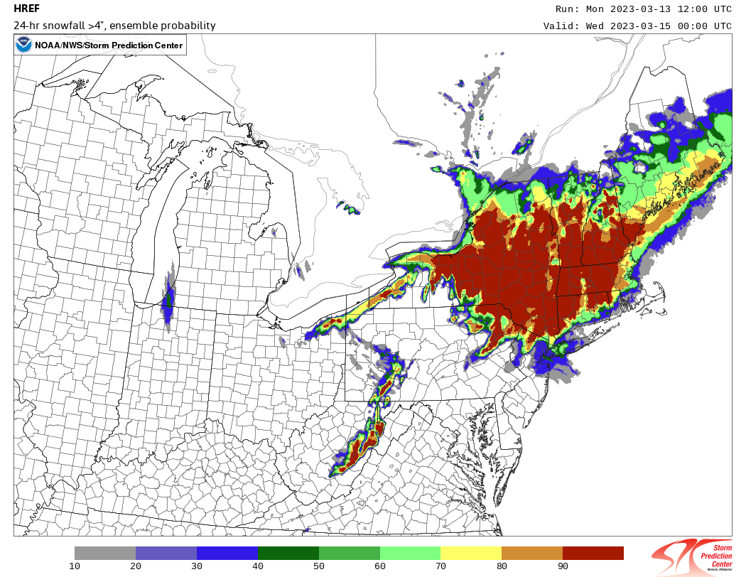
HREF's... don't think we need the final pane...


-
9 minutes ago, dmcginvt said:
exactly
As said many times in this forum, no one lives at 500mb.
-
1
-
-
12 minutes ago, dmcginvt said:
THe irony? The canadian models are good for me up here in VT and have never changed. But you guys slam them left and right. NAM and GFS have improved here as well, after going so far as saying Im getting ZERO. Who really knows they are just models that cant deal with phasing. And they've all done poorly this winter. But if there's a model that gets most dissed it's the canadian both long range and hi res. Sure the icon and ukmet probably top that chart, but it's gfs/euro/gefs/eps/ nam that everyone follows. Until the gem or reggie fits your narrative. then they are ok. I personally feel like they arent ok and are usually wrong. And thus agree with the masses. But until someone does independant verification on all of them how we do we really know
https://www.emc.ncep.noaa.gov/users/verification/headlines/acc_31days/
-
2 minutes ago, weathafella said:
You telling me in the entire 6 state region that's the issue? No it has to be a glitch. ORH 3 inches? Ray 1.9 inches? No snow outside of a dumping in the Berks? 925 crashes by 18Z Monday. Something is wrong.
Could be but if you switch the maps back two days it's been consistently on the low side for snow for most of eastern new england. Had more in western parts a day or two ago but has scaled that back.
-
2 minutes ago, weathafella said:
Right-obviously an issue here...
I think it's the thermal profiles. 2m and 925mb is warm for most of the storm, so its seeing rain.
-
3 minutes ago, weathafella said:
What happened with the pivotal uncle snow maps? No one in New England gets snow......lol
-
 1
1
-
-
7 minutes ago, mannynyc said:
Seems trustworthy

Point taken, but that looks more like an output error on TT because it's on the edge of it's data domain than the model itself. Same frame on NE view:
-
1
-
1
-
-
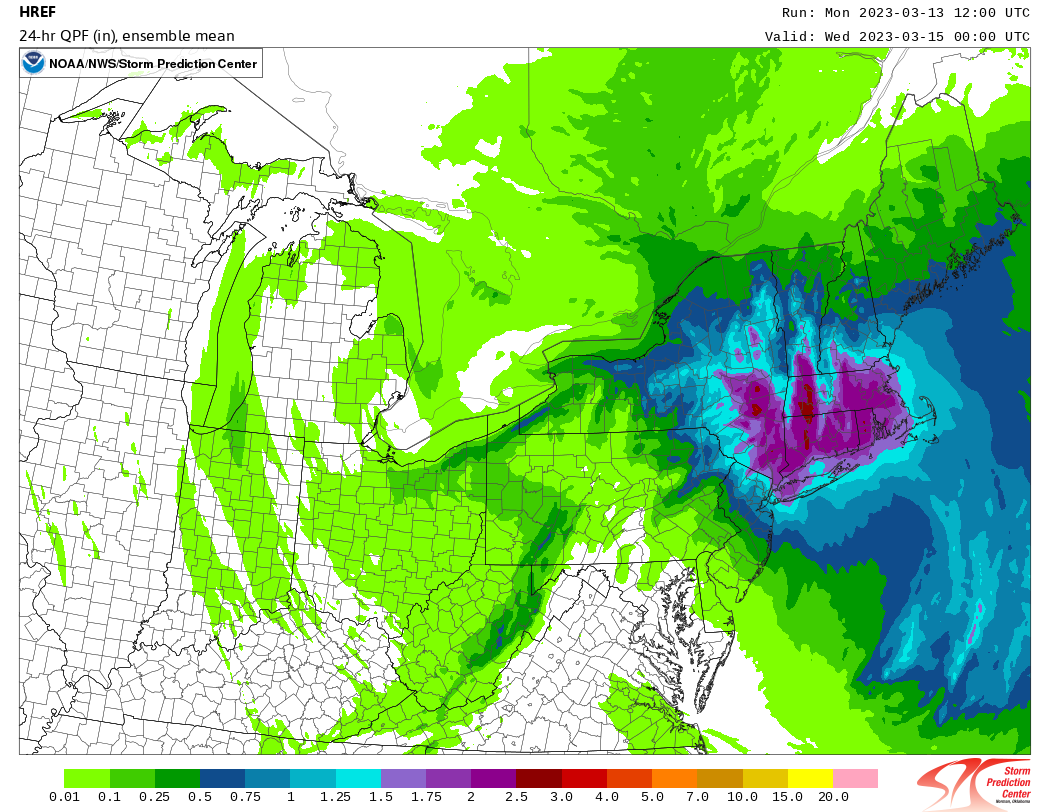
The herp has some big winners and big losers (coastal plain)...
-
3 minutes ago, dmcginvt said:
I dont understand you people that constantly say the gem and reggie suck and then look to them when it favors you? What gives? Also Is there a verification site that compares??
The Canadian models have been consistent. So they need to be weighed this time around a little more than usual. And going back several years, the Canadian models have "hit" on storms in the past. Just not as many as the Euro or the GFS.
-
3 hours ago, bristolri_wx said:
I wouldn't give up on larger numbers south of the pike just yet. Would like to see one or two more outputs of garbage before locking that in. Still lots of atmospheric uncertainty...
And just like that 00z models start rolling in and it's a slightly different story than 18z...
-
1
-
-
I wouldn't give up on larger numbers south of the pike just yet. Would like to see one or two more outputs of garbage before locking that in. Still lots of atmospheric uncertainty...
-
2
-
-
2 hours ago, Typhoon Tip said:
It’s not fact and you’re making shit up to make your point I can get the charts and prove it to you if you want no actually I’m not gonna do that I’m fucking had it with you people
I haven’t checked in for a few days… excited to see the models for early next week… then this…

-
1
-
2
-
-
Heavy pingers mixed with rain here, 33. It’s a loud night between the sleet and the wind gusts…
-
2 hours ago, Torch Tiger said:
let's goooo
3 hours ago, Torch Tiger said:

-
14
-
-
2 hours ago, WinterWolf said:
It can certainly produce in March too…we take. Mother Nature doesn’t care what we want, or when we want it, as we saw all winter up til now. She’s coming for us…just later. That’s some serious cold and a serious set up.
As we know and have been trying to tell folks for yrs…March is greater than December with regard to winter.
I know I know, and I’m grateful we will get some winter weather in March. It was born during a March snowstorm according to my parents. Just wishing it showed up earlier if for anything to show being an optimist for late Jan and parts of Feb wasn’t a total miss!
-
2
-


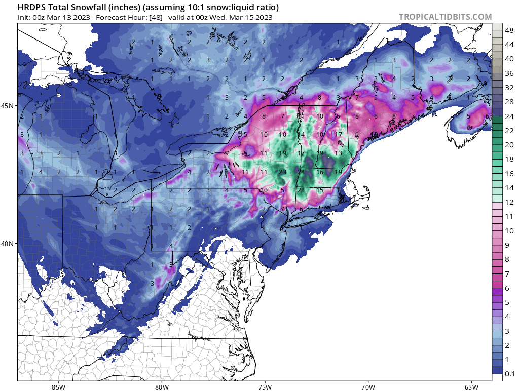


The last hurrah? Putting all the eggs in the Tuesday 3/14 basket
in New England
Posted
The HRRR still makes the finale for this storm interesting for the coastal plain. Pinwheeling the phasing lows south through Mass. Bay and the Cape. Just to the west of that things will be quite "violent" for a few hours... We are in the HRRR wheelhouse now inside of 12 hrs so lets see how well it forecasts this...