

bristolri_wx
-
Posts
1,477 -
Joined
-
Last visited
Content Type
Profiles
Blogs
Forums
American Weather
Media Demo
Store
Gallery
Posts posted by bristolri_wx
-
-
So much for that modeled NW hook/tug. Entirely gone from guidance… due north it is.
-
 2
2
-
-
2 minutes ago, WhiteLawns said:
Anyone gonna talk about how the gfs saw this happening like 15 days ago?
GFS/GEFS did a good job on this one, but if it ever gets a hurricane track 15 days out it’s pure luck. However it has been in the ballpark and not waivered as much as the Euro throughout Lee’s existence. Score 1 for the Americans!!
-
In weather model news, Pivotal has the new RRFS, which is replacing the RAP and HRRR sometime in the next year or so:
https://www.pivotalweather.com/model.php?m=rrfs_a
Doesn't look like it's consistently getting data as of yet...
-
7 minutes ago, STILL N OF PIKE said:
I’m interested to see the coastal flooding for this from the surge , I think it’s a wildcard to a degree , that is where I think any damage may surprise to the upside , literally on the beach .
The circulation Is huge and If that backs in enough to get onshore winds to gale force with the giant wave action on top , that is really and has really been my area of excitement / concern / interest .
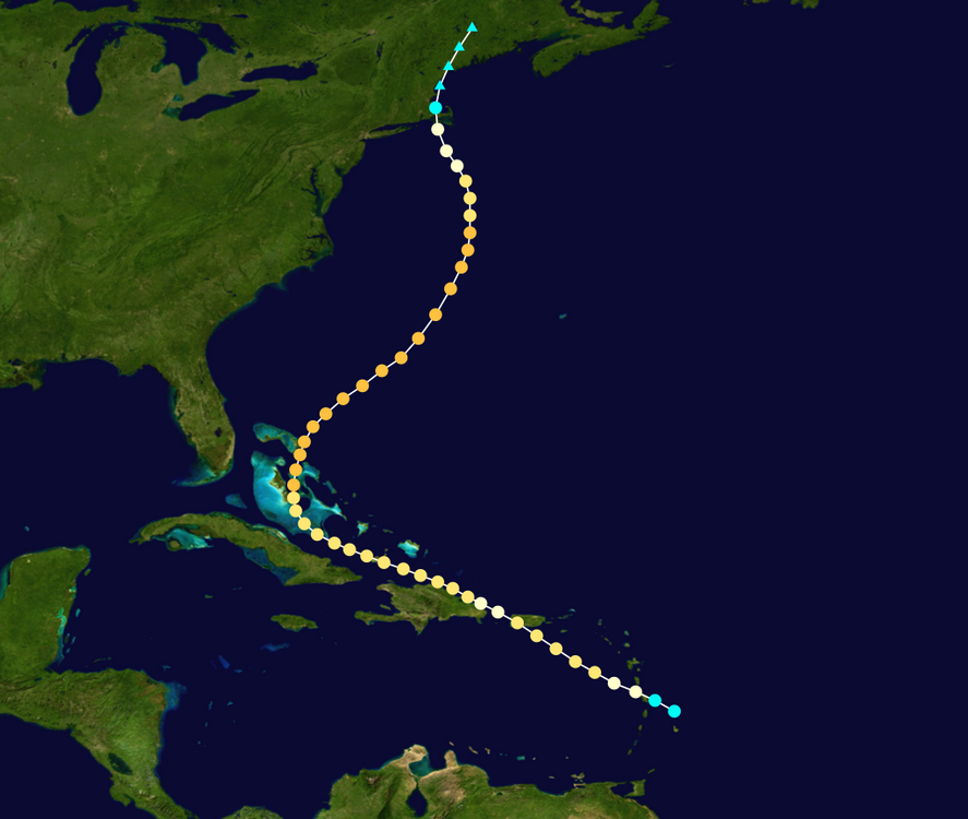
This could be a major concern in eastern facing areas, especially along the coast of Maine. Even though this will be nor'easter strength when it's decaying east of Maine Lee's remnants will probably have more ability to generate coastal flooding because of its strength and size before it begins to wind down. This is probably of more significance than wherever Lee's remnants make landfall.
-
1
-
-
1 hour ago, dendrite said:
Took me 15 minutes to figure out WTF this guy was talking about in relation to Tropical Tidbits. To think in my younger days I would watch the Long Ranger on Accuweather Pro to get his opinions, lol...
-
23 hours ago, tiger_deF said:
If we get both a Lee landfall/close brush and Nigel becomes a threat, would this be the most active tropical period for NE in recent history?
Nigel’s targeted landfall is the west coast of Scotland. Take that for what it’s worth.
-
 1
1
-
-
13 minutes ago, 40/70 Benchmark said:
Meaningful...sure, in the sense of major nor'Easter ...said that all along. But in my world, that is "who caresville".
I agree in principal but we’ve had many strong autumn nor’easters that have caused significant amounts of winds and damage… just not hurricane level stuff.
-
“The environment ahead of Lee is expected to gradually become less
conducive for the hurricane as it moves into a region of higher
wind shear, drier air, and over progressively cooler SSTs.  These
conditions favor weakening, but since the system is so large the
weakening process should be slow.  The NHC intensity forecast is a
little lower than the previous one, in part due to the initial lower
wind speed, and remains near the HCCA and IVCN guidance.
Regardless of the details, there is high confidence that Lee will be
a large hurricane near the coast of New England Friday night and
Saturday.

It should again be noted that the 34- and 50-kt wind speed
probabilities beyond 36 hours in the text and graphical products are
likely underestimating the risk of those winds occurring.  This is
because the forecast wind field of Lee is considerably larger than
average compared to the wind field used to derive the wind speed
probability product.”
Stick a fork in it - though perhaps the Tropical Storm force winds will be farther out than we would normally expect. The fact it’s taking a while to wind down may influence that as well. Looks like the rain risk is fading away as well, 1-2” for ESNE 2-4” for Maine…
-
The narratives around here change about as quickly as the weather.
Early on people were excited about direct hits to New England with Lee being a hurricane, and possibly strong, with this unusual eastern track Lee is taking.
Some are treating this as a strong nor’easter because Lee will be acting more like that than it will be a landfalling New England hurricane. This doesn’t mean we won’t see effects and damage. But it won’t be like anything like a land falling hurricane that take the usual west of the Gulf Stream track that those storms have made. This will be a decaying storm, over cooler waters, not phasing and experiencing much extra tropical transition until it gets farther pas our area. Nor’easters have also produced damage to our area as well, without snow.
There is nothing I see in guidance from models or even the NHC that says otherwise. It’s gonna be a very crummy weekend for a large chunk of New England which falls on the westerns side of Lee.
-
2 minutes ago, WxWatcher007 said:
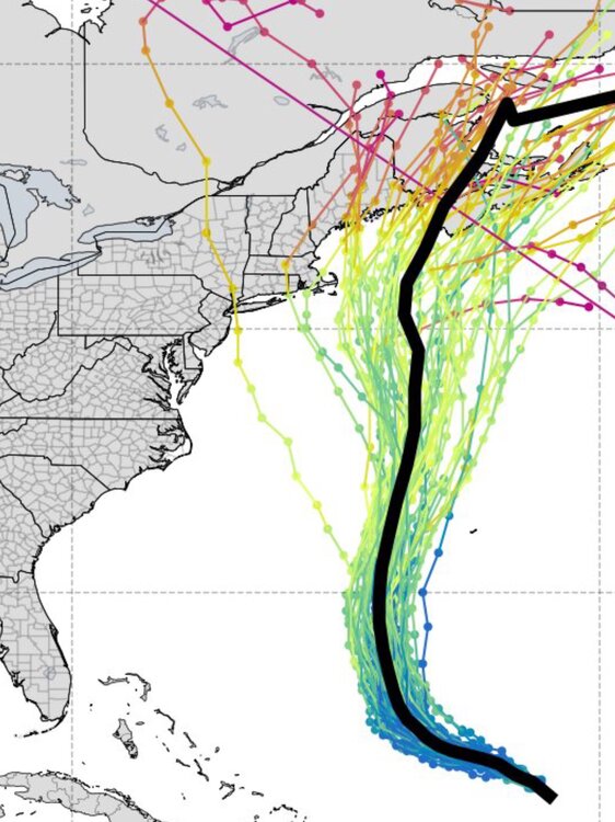
Right. Looking objectively at the ensemble graphics I posted, the jump west yesterday was significant. Nobody could have taken one euro op run that was an outlier and immediately jump on board.
Agree that this morphs into a compromise deal. That’s usually how these go. I’m thinking just west of Bangor when all is said and done, leaving a fairly close approach for the Cape.
Not that it matters that much for anyone who has a tree that falls on their house, but Lee might be barely tropical by the time it gets here.
Biggest risk here is tree damage from higher winds considering all the rain we have gotten before Lee arrives. Should be quite wet and breezy east of the track. I think many will be disappointed by gusts though.
-
2
-
-
30 minutes ago, ineedsnow said:
still 4 days plus days out I wouldnt say that yet
Just because something is possible doesn't mean it's going to happen. There's a very high probability that this will be a nothing-burger for most, if not all, of New England. There is a very low probability of other outcomes. The NHC forecasts have been outlining this for a while now.
-
Lee really wants to interact with that Canadian shortwave and phase with it at 500mb. If that shortwave slows down then Lee will move towards it. Right now it goes right by into SE Canada and Lee follows it N/NNE.
Not certain by any means, but the trend all day on the GFS has been slightly east each run.

-
1 minute ago, STILL N OF PIKE said:
My guess is 0z comes west looking at hr 72
Already turning NE by 75/78...
-
1
-
-
30 minutes ago, WJX231 said:
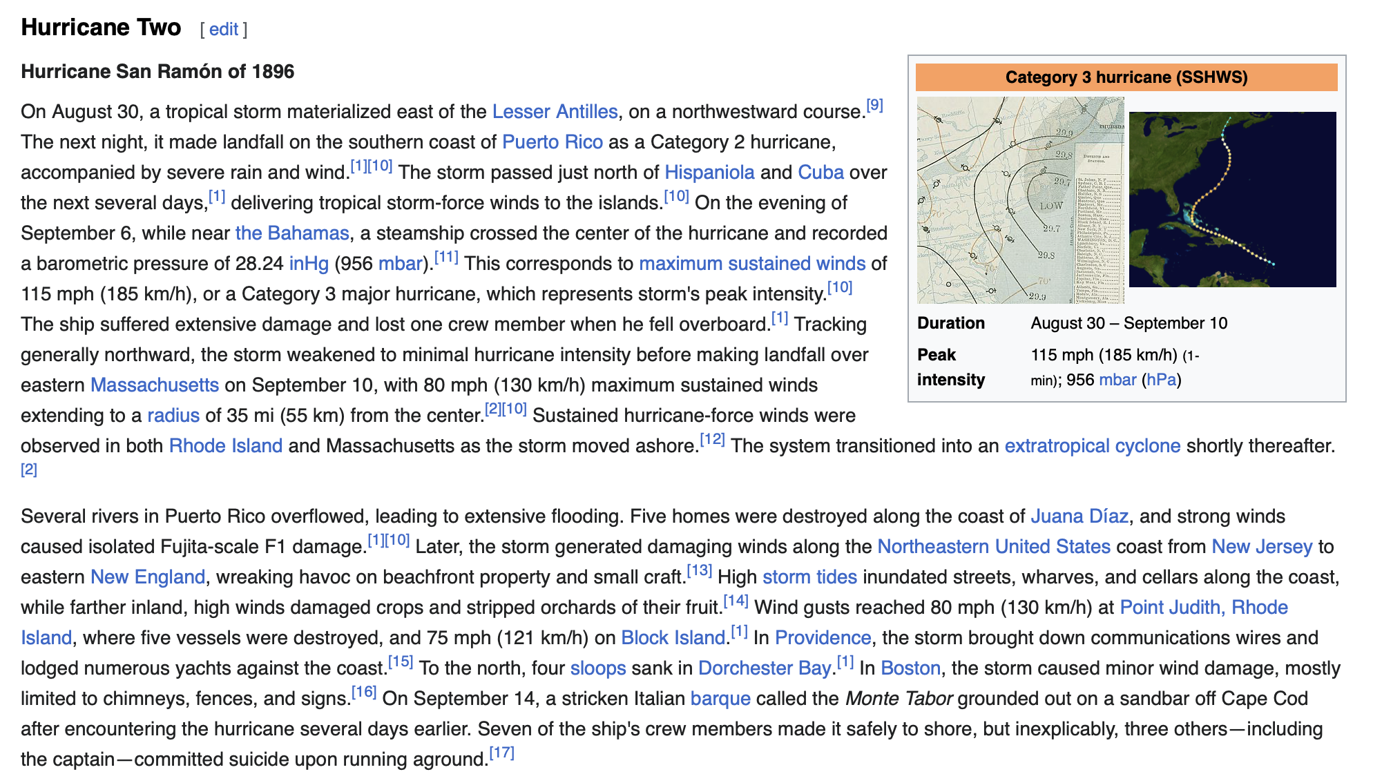
What about the 1896 San Ramon hurricane in August/Sept? Surprised nobody has mentioned that one. Took a Sandy-esq turn into SE Mass. Also interestingly, it was the same year of the last major hurricane in the Big Bend region before Idalia.
Excellent point. Here's more info about that storm. Similar track though it looks like it got much farther west than Lee will.

-
 1
1
-
-
11 minutes ago, Damage In Tolland said:
The most useful thing about this post is a direct link to this site:
http://arctic.som.ou.edu/tburg/products/realtime/tropical/
-
2
-
3
-
-
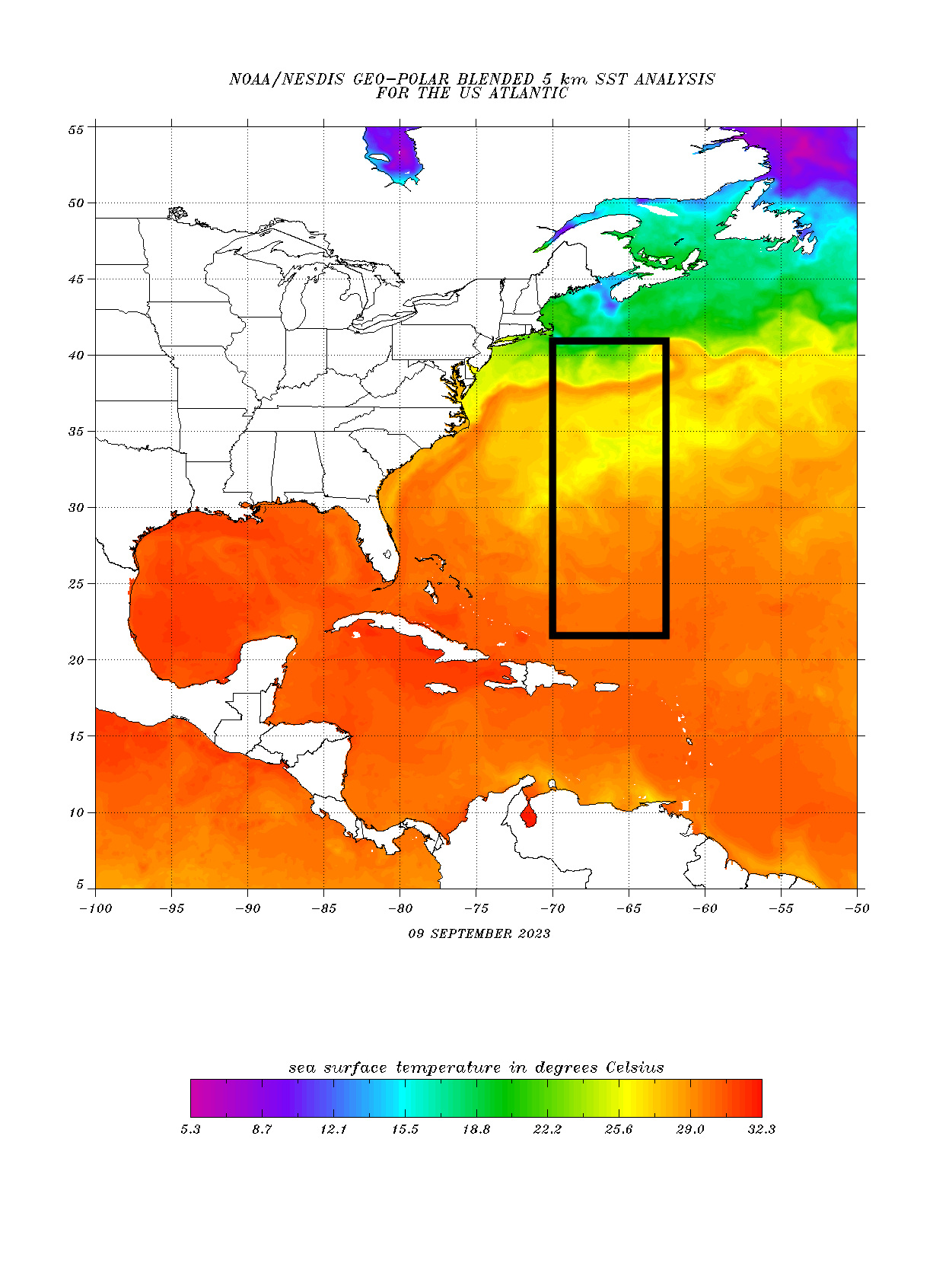
“Lee is likely to move over a cool SST wake left behind
by Hurricanes Idalia and Franklin later this week, and cross over
the north wall of the Gulf Stream by the end of the forecast period.
The combination of cooler SSTs, an increase in shear, and dry air
entrainment should cause a steady decay in strength late this week
and over the weekend.”

-
1
-
9
-
-
3 minutes ago, Twitching Trucks said:
Jesus H Christ. You know what I love? Wading through dozens of bickering fool posts about who wants the end of the world and who doesn’t, just to get the one out of 10 that actually discuss weather and the science behind it. I’m not even knowledgeable enough to be called a neophyte here, but I love the weather…all the weather. It also effects my job, so I come down to these first 3 layers of hell to gain further insight about it…but damn, it’s getting painful to glean the useful bits out. Kick me out of you want, call me all of the name, I don’t really care, but you guys are nearly intolerable.
.You must be new here…
-
2
-
1
-
-
5 minutes ago, Torch Tiger said:
Even a basic 40-50mph gust could uproot or snap a tree at this point
Truth. If we get moderate wind and rain from Lee it still could be a big mess.
-
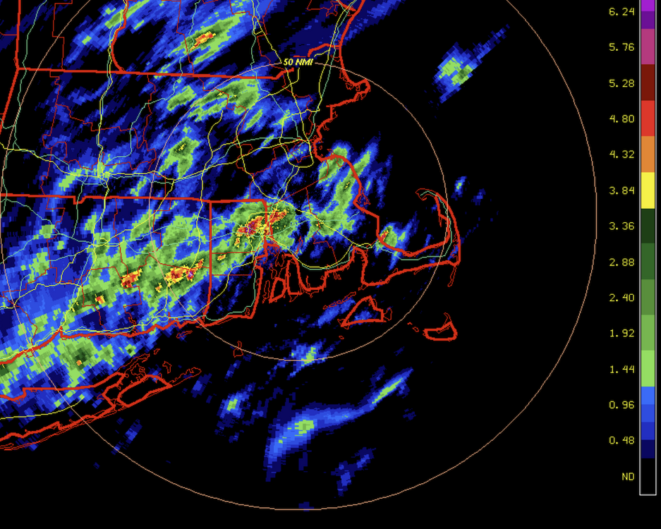
It's been torrentially downpouring here in N. Providence for almost 2 hours now. Radar estimated is at the 4-6" range were we are, and more to come. Some reports of flooding...
-
1
-
-
4 hours ago, weatherwiz said:
Lee would largely miss those warmer waters (assuming anyways). Historically, to get a significant cane to make landfall up here you need it to be hauling as it would have less time to weaken between being off the Carolina coast and a landfall up here.
A slower moving storm traversing these colder waters though will give the storm ample time to undergo internal structural changes and evolution from tropical to ET

Agreed, and you provided a better map...
-
1
-
-
1 hour ago, joey2002 said:
00z eps only has a couple SNE landfalls
I see that one ensemble member was run off @MJO812’s basement computer. So nice of him to donate computing resources to the ECMWF.
-
1
-
-
29 minutes ago, RUNNAWAYICEBERG said:
That’s one way to look at it. The other is to look at all those right of mean tracks.
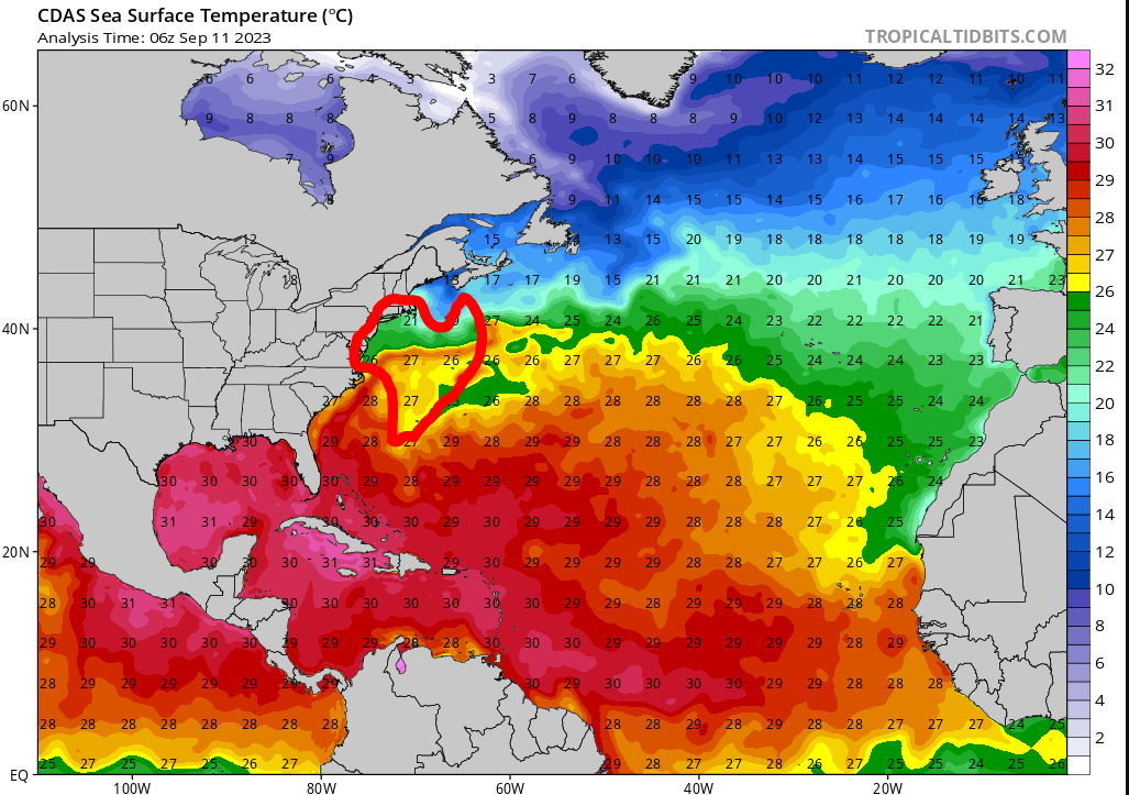
Lots of mediocre water temps for tropical with that EPS track due north at 67 W. Misses out on the nice warm temps of the east coast of the US and the Gulf Stream until it hits 38 N... probably weakens more than modeled as it goes over those cooler temps.

-
1
-
-
13 minutes ago, bristolri_wx said:
LOL I got weenied for this?

BRING IT!

-
1
-
2
-
5
-
-
2 minutes ago, Damage In Tolland said:
That’s how 38 of as. Wet humid summer like this one and heavy rains week prior . If not Lee it’ll be the first ne later following week . One way or another, it’s coming
That second storm has a much more of a track that has New England possibilities for landfall. If that one forms like the GFS is hinting at, we'll need to watch it.
-
1
-
 1
1
-


Hurricane Lee--Glorified Nor'Easter or Legit Tropical? Near Miss or Direct Hit?
in New England
Posted