

bristolri_wx
-
Posts
1,477 -
Joined
-
Last visited
Content Type
Profiles
Blogs
Forums
American Weather
Media Demo
Store
Gallery
Posts posted by bristolri_wx
-
-
5 hours ago, CoastalWx said:
I love how he thinks Tolland is like Cincinnati in the Spring.

“Baby if you ever wondered, wondered whatever happened to Spring.”

-
 1
1
-
-
If you look at the ultra long range 00z GEFS the first week of March is a nice warm up, followed by a cool down. I wouldn’t pull out the shorts and a/c’s just yet.
-
We don’t need El Niño or La Niña, we just need Canada to have relatively normal cold air again. As long as Canada continues to be a furnace our Winter snow chances will continue to be reduced. Our general patterns were favorable several times for snowfall, only for there to be marginal temps making accumulation difficult or impossible. Sometimes you don’t realize how a +10 or +20 500 miles away makes 29 degrees turn into 33 degrees in New England.
-
1 hour ago, CoastalWx said:
Well it has been autumn so…… lol
I promise to not start one ever again!

-
 1
1
-
-
21 hours ago, Cold Miser said:
...and the autumn 2023 thread is still going strong.
Did I start the longest lasting Autumn Banter thread ever?
-
4
-
-
Had about 1” of fluff here. It melted as soon as the sun came out.
-
38 minutes ago, WinterWolf said:
Yes, this is a great point. I think that many envision mild sunny days in the 60’s, and dry stretches when they think of Morch being above normal, and winter being over Lol…that’s almost always never the case. Sure it’ll be above normal, but more likely just as you explained. Which really sucks.
Yes exactly. Some may be envisioning shorts and sandals and while that could happen, I feel like disappointment will continue, but just in the other direction.
-
 1
1
-
-
I feel like this forum might go crazy if the “Morch” ends up being 45 degrees and cloudy for weeks on end with +20 low temps at night.
-
23 minutes ago, Damage In Tolland said:
Morch is going to be an all out furnace . You can see it on all LR guidance
Bring on Morch! Have some grass to seed in the yard, would like to get an early start since I missed my window in the fall.
-
1
-
1
-
 1
1
-
-
Just removed about 3.5” of Hungry Jack from the driveway, thankfully the electric snow blower could handle it. Would love to know the ratios on this stuff considering it was snowing moderately to heavy for most of the storm. Probably 4-1 or 5-1 type stuff. This was probably about 5” of snow at one point.
-
2
-
1
-
-
3 minutes ago, weatherwiz said:
Exactly. This is why I get so bent out of shape with the snow maps. They're just leading to lazy forecasting. Ultimately, forecasting is a science which requires a great deal of time and effort. Now, I get in today's day and age where everyone is so busy and has so many responsibilities that it's difficult to put that effort in, but we're only hurting ourselves that way.
Fundamentals are important. Take sports for example, you can have the most talent team, best players, but if you can't execute the fundamentals, you aren't winning in the end.
When forecasting, the fundamentals should be applied first and always. If one is going to look at snow maps or QPF and see there is a cut-down, the questions needs to be asked as to why that is and whether it makes sense. When looking back at how all guidance was handling the mid-levels, the evolution of the mid-levels, jet enhancement, the QPF cuts should not have made sense.
I guess though hindsight is 20-20...its always easier said than done in the end, but you can't ignore the fundamentals and forget why fundamentals are important.
I agree with everything you said 100%, and I don't have met training so I'm not even in much position to take an alternative angle. That being said, I think even the folks at NCEP and other agencies were probably wondering what was going on with models yesterday afternoon, and by 6PM they had hurricane hunters out doing data readings. It didn't shock me that @Ginx snewx started posting HRRR runs that were "improving" a few hours later. Perhaps those flights would have been done anyway for research purposes but there was definitely a period yesterday where something made the models start show something different after several days of consistency.
-
1
-
-
Made the Bristol to Providence track into work between 8:30 to 9:15. Moderate to heavy snow the entire way. It's sticking pretty good to grassy areas, but roads are just slushy. It's been hovering 32 the entire time. Eyeballing about 4" outside my office. Don't have a yard stick here. It super heavy slop, but looks delightful outside.
-
1
-
-
25 minutes ago, TheSnowman said:
0.5” ON THE GROUND OUTSIDE OF GRASS OR PLASTIC!! 0.5”!? And You people have 6”-10”??
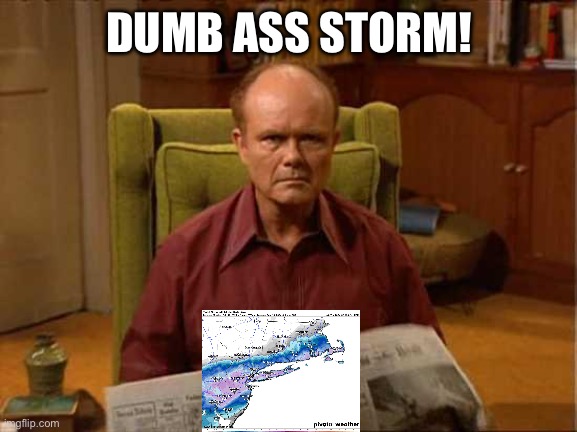
F*** THIS STORM! In the past 9 days I’ve had to deal with the Chiefs Winning, Mahomes winning a Historic Game WITH an OT coup to boot, Narcissistic Swift & Asshat Kelce taking over the God Dang World seeing unprecedented records and power, my industry has gone So Woke at the Grammys you can’t recognize it, Brandon doesn’t know he’s flipping Alive as President, and now ANOTHER Failed storm like the last 7 “big ones” in a Row here the past 2 years??
Here you go man:
https://weedmaps.com/dispensaries/in/united-states/rhode-island/cumberland

-
1
-
2
-
-
46 minutes ago, jbenedet said:
For all the rejoicing from the clowns in CT about a positive bust. That's only happening in Hartford CT area out providence RI to ( their back yard--shocker), so far. The rest are busting low or on par with last night's paltry guidance.

-
16
-
-
I mean let’s be honest when the GFS is out to lunch in the other direction against consensus, we usually toss it. In this case it’s still showing much more than anyone else, it could just be behind, unless we see a jog north on the high res meso models or radar changes, it’s probably not happening as depicted on the GFS.
-
1
-
-
-
19 minutes ago, weatherwiz said:
My guess it's just moreso the initialization of the features and how they're evolving in real time. Just going through quickly but between some guidance and today, the differences between the evolution of the northern/southern streams don't seem too significant but certainly enough to result in larger differences at the surface.
I'm also getting the distinct impression that this preceding airmass being hot garbage provides wide swings when you start looking at snowfall maps with little change in the upper levels. If we had a colder airmass in place, ratios wouldn't be as much of an issue considering the overall placement of the low pressure. It going a little farther south, as mentioned in the discussions, causes the better lift and the mechanics to cool off the atmosphere more quickly and comprehensively go along with it, and no one is sure if back side cold air can balance that out. A week ago we weren't even sure a snowstorm for a large part of the area could materialize considering the confidence in it being +10 to +20 for several days before hand and no cold front coming before it to inject cold air into the region.
-
1
-
-
Out of personal curiosity, I would love to know what data that got ingested in the last 12-18 hours that caused this much of a hiccup. I see the reasons for the change, but man, what a huge swing right before go time. And before you say the Ukie was on this the entire time, the reason why the Ukie didn't like this storm on earlier runs does not seem to match the trends on the other models in the last 12 hours. I guess the models were threading the needle the last few days with a perfect setup of chaos that didn't actually occur?
-
1
-
-
BOX AFD:
QuoteWell, I`ll get right to the point with this update, there`s been a big change to the forecast this afternoon based on a remarkably late but notable trend in the 12z/18z guidance which now keeps the bulk of the snow centered over the south coast of southern New England. This change is due not only to a southern shift in the track of the low but also a notable shift in the 500 mb trough; with a slower and less amplified solution and the northern and southern stream energy failing to phase/strengthen as they pass through the region. This shift has notably moved the zone of mid level frontogenesis to the south, and since we typically see the best forcing/banding to the northwest of the maxima this places southeast MA/Cape Cod and southern RI in the bullseye. BUFKIT soundings do indicate decent omega (forcing for lift) within the dendritic snow growth zone further north into MA, so we should still see some decent snowfall there, but the maxima looks to be south and east. While this is remarkably late in the game for such a relatively big shift, nearly all of the 12Z guidance including the 12Z ECMWF, 18Z NAM, 18Z HRRR and more show it. The new forecast calls for a swath of 6 to 10 inches across southeast MA/RI with a pretty tight gradient to the north down to potentially nothing in far northwest MA. Uncertainty remains high, however, given marginal temperatures at onset (though good dynamics should help cool the column to overcome this) and potential for a shift back north with overnight guidance. This southern shift brings slightly cooler air which may help mitigate snow loading risk a bit, but a wet, and rather heavy snow continues to be expected. Blizzard conditions are possible, especially on the outer Cape where the strongest winds are expected, with gusts has high as 55 mph possible. Elsewhere winds will be gusty, blowing 30- 40 mph over southeast MA and along the immediate coasts of MA and RI. The Winter Storm Warning has been expanded into Cape Cod and the islands while it has been downgraded to a Winter Weather Advisory for western and north central MA.
-
2
-
-
17 minutes ago, NeonPeon said:
That dark grey goes up into the bay for sure. There's no way that the southern part of aquidneck Island is At 5 inches plus. I think the official number for Newport is at 6.6 on the season, but Newport proper has definitely not seen close to that. That's oddly the number at the airport, which is in Middletown, and every half mile you go north makes a difference, incredibly. My very unofficial total is half that. It's definitely nit picky but if my winter is going to shit the bed, I at least want it to make a stain.
The dark gray doesn't go that far up Narragansett Bay. I'm at around 10" here for the season in Bristol.
-
Wow 4-8” down here wouldn’t be terrible. I’ll take it. Better than the last three white rain storms we have had.
-
13 minutes ago, CoastalWx said:
I’m such a Debbie.

-
4
-
-
26 minutes ago, NotSureWeather said:
I think most check the dates, but just in general. It’s cool that you post maps, and I appreciate it, but it seems you will include other events in those maps which skews the totals, obviously. I know I’ve seen other members here, with much more tenure than me, ask you to be a bit more accurate with the maps when you post them. Sorry, hope this isn’t coming across as rude. You seem like a good guy.
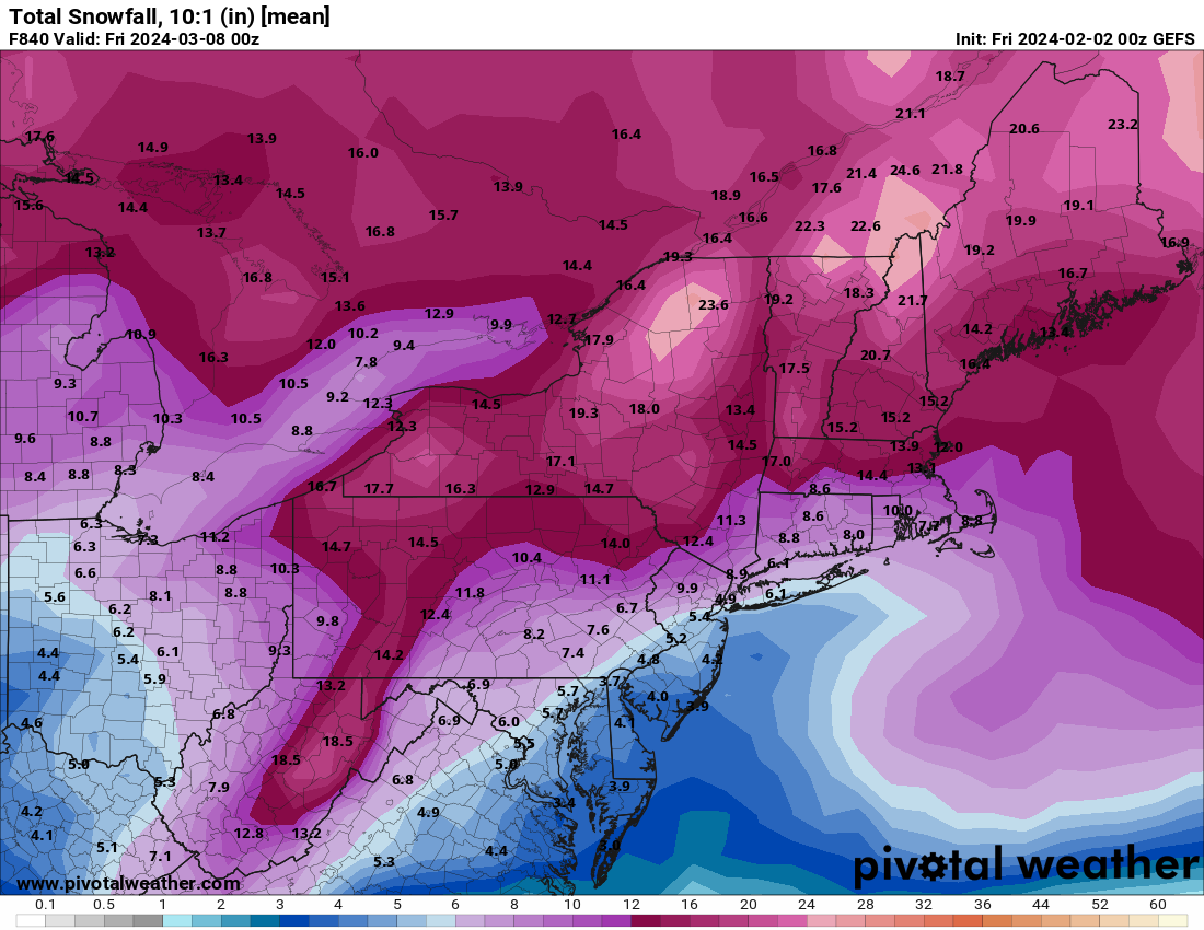
In the spirit of this discussion, here's a long range total snowfall map.


-
2
-
1
-
1
-
 2
2
-
-
1 hour ago, CoastalWx said:
I like how it’s a BM track with mix line getting to the pike.
#Winter2024. Terrible.


March 2024 disco/obs
in New England
Posted