

bristolri_wx
-
Posts
1,477 -
Joined
-
Last visited
Content Type
Profiles
Blogs
Forums
American Weather
Media Demo
Store
Gallery
Posts posted by bristolri_wx
-
-
2 hours ago, CoastalWx said:
 Go years without a double digit storm like I did when I was a kid and see what happens.
You end up a meteorologist? This is why support systems are in place, to keep our world safe from this result.

-
19 minutes ago, mahk_webstah said:
My wunderground suddenly giving me 10” on 22-23
Wowza. Aren’t those wunderground forecasts generated from the Amiga model?

-
1 hour ago, WxWatcher007 said:
I may need to come out of retirement and reopen a Panic Room up here.
Last years Winter Panic thread was started on 12/1/21, so we're two weeks late this year. Time to induce!
-
1 hour ago, 40/70 Benchmark said:
Such a disappointing evolution.
Holy shit, do I need an el nino.
Interesting information... taken with a grain of salt.
https://www.washington.edu/news/2022/10/03/study-suggests-la-nina-winters-could-keep-on-coming/
-
26 minutes ago, TauntonBlizzard2013 said:
Surprise incoming for RI?
so close here
Juicy band overhead. Making up for the snow hole earlier lol…
-
Snow hole… 33… holding steady at 1/2”

-
 1
1
-
-
Pleasantly surprised with the 1/2” on the grass here. Not much sticking to pavement. We’ve had a few more lulls here than others (as usual). Definitely feels festive out there.

-
1 hour ago, George001 said:
 The low in the mid west is turning into a Miller B and looks like it’s somehow pulling the coastal low in to absorb it. I…. have no idea what I’m looking at here and what this would look like if you extrapolate it
We are going to be going through a pattern transition. The operational surface maps are going to be hot garbage outside of five days while this is taking place. I wouldn't take anything verbatim outside of five days at the moment. Stick with ensembles days 6+...
-
2 hours ago, George001 said:
The Pope is very angry today, some shit must have gone down at church. I’d bet he caught a certain Brooklyn cop looking at weather models during a sermon or something.

-
 7
7
-
-
8 hours ago, CoastalWx said:
Is there a modal upgrade today? What's being updated.
https://www.weather.gov/media/notification/pdf2/scn22-104_gfs.v16.3.0.pdf
-
2 hours ago, CoastalWx said:
Saturday May be the last torch for awhile. Could be low 60s.

-
2
-
9
-
-
3 hours ago, CoastalWx said:
Yes it’s a good look and I’d take it a million ways from last December. But when asked how I felt about snow, I think it’s wise to approach it more conservatively for you and I. But as I said….I can see how this would be good for almost all of us too. I just don’t have the information in front of me at this moment to make that call.
This can't be stressed enough! Regardless of the outcome, there's definitely more chances for wintery weather coming up based on the pattern forecasted compared to the December 2021 pattern which was terrible for us.
-
Wow, can't believe that the December thread is 17 pages long already and it's not even 12/1. Even the last 18 hours worth of posts have been kind of crazy.
I'm not sure what the fuss is about. I'm no met, but it's just nice to be in the ballpark of a favorable pattern in December, regardless of the outcome. Go back the last few years, and there wasn't anything like this really modeled or discussed in December model runs. Even if it doesn't turn out exactly as we hope, it should be a volatile pattern with chances for all sorts of weather outcomes. It definitely does not look like last year, so already that's going to be an improvement.
I'm just hoping for seasonable weather around Christmas. Whether there's snow on the ground, that's always tough, especially where I am, but there's been too many grinch storms last few years where I'm driving home on Christmas Eve at 10PM and its 50 degrees and foggy. If this anticipated pattern is delayed a few days, I'm not sweating it, with the hope it lasts through Christmas, even if it ends up dry and cold.
Back to your regularly scheduled early December trolling and bickering.-
3
-
-
4 hours ago, STILL N OF PIKE said:
This forum is like a
realityshit show , it’s great .Fixed that for you.
-
 1
1
-
2
-
-
2 hours ago, Damage In Tolland said:
I’ll rip a boob back occasionally too. But man .. take a risk.. try a few IPA’s. I promise you .. you’ll thank me
George says we can all get along...
-
2
-
1
-
-
Love these fronts that kick through and the wind starts gusting as the CAA moves in. Such a big part of autumn and winter in New England.
-
2 minutes ago, Snowcrazed71 said:
Have you ever seen that guy that does a YouTube videos Direct Weather? I don't think he's a weather guy, he just takes the models and just posts them on there like that's what's going to happen. His latest video he showed the GFS and that there's a big warm bubble that's going to take over in December. I kind of think that's a little premature.
He's very enthusiastic but everything is major, or a monster, or humongous. . I definitely get a chuckle out of his videos. But kudos for his enthusiasm
Terrible… That’s YouTube monetization for you. I could make a good amount of money too posting the NAM for every snow threat. Model maps without context are the CNN/Fox News of weather forecasting.
-
1
-
-
Happy Thanksgiving everyone! Enjoy the turkey, beer, football, and climo weather!

-
4
-
-
1 hour ago, Great Snow 1717 said:
it sure doesn't seem as though the pattern change will be "complete by the 25th"
What are you talking about??? At the time it was predicted temp anomalies were +20 and models (and some posters) were hesitant to break the pattern. The last 10 days we’ve gone from +20 to normal/slightly below. What part of the pattern change did you not see occur.
For those that enjoy winter, seeing things return to climo is a good thing, even if it doesn’t result in violent blizzards before Thanksgiving.
-
1
-
1
-
-
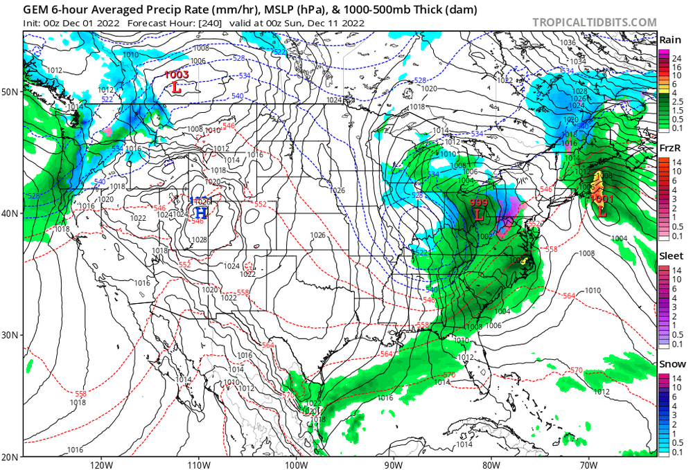
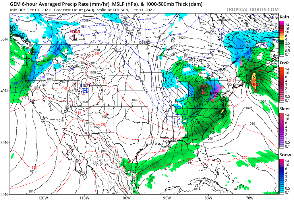
2 hours ago, Torch Tiger said:
Through December 9th, wow. nearly snowless
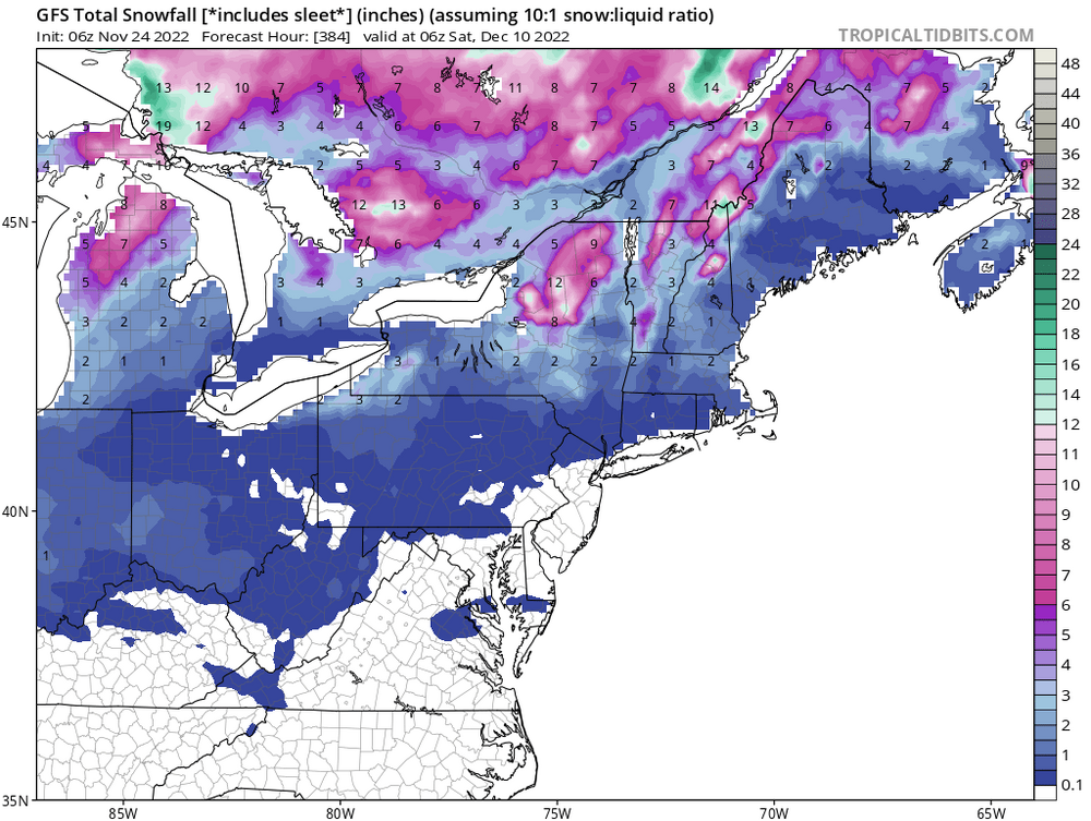
Thanks for posting this!!! Hopefully your post has the same results as Stein posting 384 QPF maps a few months back. Pretty sure it didn’t rain for 6 months on those 384 hr runs. Have a Happy Thanksgiving, be sure not to torch your turkey!
")
-
2
-
-
2 hours ago, Torch Tiger said:
It's nice seeing no meaningful snow in the forecast for the foreseeable future. The heart of winter is over in a couple months, let's keep spinning wheels and we're there!

-
3
-
 1
1
-
-
1 hour ago, ORH_wxman said:
Got up to 73 here. But right now 67F so slowly starting CAA.
As for beyond today, euro pretty close to starting interior as a burst of snow. Mostly N of pike but can’t rule out a few flakes at start south of pike on early Wednesday morning. Euro has a solid advisory event for NNE. Maybe low
Tip is also right about the model guidance still being divergent on what happens beyond next weekend. Some try to relax the flow and go to seasonably mild weather (but not epic torch levels like we saw so far this month)…and others like GGEM keep the cold around.
My non scientific gut feeling is that the below normal cold hangs around a little longer. I think we are seeing the usual model waffling around a major pattern change that is afoot…
-
1
-
-
4 hours ago, Ginx snewx said:
I used to date Cynthia Bush
Did she have nice blooms?
-
1
-
-
Excellent job Ray! Was waiting for the release, and you definitely delivered. This is definitely one of those "read it a few times to take it all in" articles. I await my 27"-36" of snow (I always knock off 10% of whatever is predicted for PVD). Thanks for providing this to us, it was quite educational.
-
1
-


"We're gonna need a bigger plow..." Massive, persistent singal now emerges discretely in the models, 20th-23rd
in New England
Posted
I weenied you for that post only because I can’t weenie myself for being excited about that map lol!